ATL: Ex-INVEST 91L - Models
Moderator: S2k Moderators
-
TomballEd
- Category 5

- Posts: 1317
- Age: 62
- Joined: Wed Aug 16, 2023 4:52 pm
- Location: Spring/Klein area, not Tomball
Re: ATL: Invest 91L - Models
First 91L SHIPS. The medium steering model used before NHC issues a forecast track extrapolated beyond xx time would suggest a very close call for the NE Caribbean. I forgot the name of the improved BAMM model. Just uses GFS forecast wind for track, not super sophisticated but not necessarily wrong.
* GFS version *
* ATLANTIC 2025 SHIPS INTENSITY FORECAST *
* IR SAT DATA AVAILABLE, OHC CLIMO USED *
* INVEST AL912025 09/04/25 12 UTC *
TIME (HR) 0 6 12 18 24 36 48 60 72 84 96 108 120 132 144 156 168
V (KT) NO LAND 20 21 22 23 25 32 43 51 63 70 78 81 82 83 84 87 90
V (KT) LAND 20 21 22 23 25 32 43 51 63 70 78 81 82 83 84 87 90
V (KT) LGEM 20 21 21 23 24 28 32 36 42 48 54 58 58 58 58 60 63
Storm Type TROP TROP TROP TROP TROP TROP TROP TROP TROP TROP TROP TROP TROP TROP TROP TROP TROP
SHEAR (KT) 5 6 3 3 5 3 4 6 6 7 9 8 11 7 9 8 9
SHEAR ADJ (KT) 0 -2 -1 0 0 0 1 2 0 -1 1 3 5 5 0 1 3
SHEAR DIR 57 67 106 188 255 158 214 119 139 166 248 239 258 245 274 286 263
SST (C) 27.7 27.6 27.7 27.8 27.8 27.8 27.8 28.3 28.2 28.4 28.3 28.5 28.3 28.5 28.8 28.7 28.9
POT. INT. (KT) 132 130 131 132 132 133 133 140 139 142 141 145 142 144 149 147 150
200 MB T (C) -53.8 -53.6 -53.7 -54.0 -54.0 -54.1 -54.0 -54.0 -53.9 -54.0 -54.2 -54.0 -54.2 -53.8 -53.9 -53.6 -53.6
200 MB VXT (C) -0.2 -0.2 -0.3 -0.2 -0.2 -0.2 -0.1 -0.1 -0.2 -0.2 -0.2 0.0 0.0 0.0 0.0 0.1 0.2
TH_E DEV (C) 5 5 5 5 5 4 5 6 6 8 7 8 8 9 9 10 9
700-500 MB RH 65 66 68 70 68 73 69 64 60 60 60 61 58 58 58 59 58
MODEL VTX (KT) 9 9 9 9 9 11 14 12 14 14 16 15 15 14 14 13 13
850 MB ENV VOR 37 44 45 42 38 39 48 27 21 16 8 2 -14 -23 -33 -32 -18
200 MB DIV -21 -28 -19 -11 -8 58 56 51 -24 -8 25 5 1 25 20 15 11
700-850 TADV 0 0 -1 -1 -2 -2 -4 -1 0 3 3 2 -2 -2 4 0 -3
LAND (KM) 1751 1787 1768 1734 1716 1706 1642 1515 1383 1263 1132 1073 925 764 654 505 341
LAT (DEG N) 12.1 12.2 12.2 12.1 12.1 12.3 12.6 12.8 13.0 13.2 13.5 14.2 15.2 xx.x xx.x xx.x xx.x
LONG(DEG W) 33.5 34.3 34.8 35.5 36.1 37.5 39.0 40.6 42.4 44.3 46.6 48.8 51.1 xxx.x xxx.x xxx.x xxx.x
STM SPEED (KT) 8 6 6 6 6 7 8 8 9 10 11 12 12 11 10 9 11
HEAT CONTENT 20 20 20 21 21 23 24 23 25 29 35 38 46 50 51 54 55
0 likes

Re: ATL: Invest 91L - Models
TomballEd wrote:First 91L SHIPS. The medium steering model used before NHC issues a forecast track extrapolated beyond xx time would suggest a very close call for the NE Caribbean. I forgot the name of the improved BAMM model. Just uses GFS forecast wind for track, not super sophisticated but not necessarily wrong.* GFS version *
* ATLANTIC 2025 SHIPS INTENSITY FORECAST *
* IR SAT DATA AVAILABLE, OHC CLIMO USED *
* INVEST AL912025 09/04/25 12 UTC *
TIME (HR) 0 6 12 18 24 36 48 60 72 84 96 108 120 132 144 156 168
V (KT) NO LAND 20 21 22 23 25 32 43 51 63 70 78 81 82 83 84 87 90
V (KT) LAND 20 21 22 23 25 32 43 51 63 70 78 81 82 83 84 87 90
V (KT) LGEM 20 21 21 23 24 28 32 36 42 48 54 58 58 58 58 60 63
Storm Type TROP TROP TROP TROP TROP TROP TROP TROP TROP TROP TROP TROP TROP TROP TROP TROP TROP
SHEAR (KT) 5 6 3 3 5 3 4 6 6 7 9 8 11 7 9 8 9
SHEAR ADJ (KT) 0 -2 -1 0 0 0 1 2 0 -1 1 3 5 5 0 1 3
SHEAR DIR 57 67 106 188 255 158 214 119 139 166 248 239 258 245 274 286 263
SST (C) 27.7 27.6 27.7 27.8 27.8 27.8 27.8 28.3 28.2 28.4 28.3 28.5 28.3 28.5 28.8 28.7 28.9
POT. INT. (KT) 132 130 131 132 132 133 133 140 139 142 141 145 142 144 149 147 150
200 MB T (C) -53.8 -53.6 -53.7 -54.0 -54.0 -54.1 -54.0 -54.0 -53.9 -54.0 -54.2 -54.0 -54.2 -53.8 -53.9 -53.6 -53.6
200 MB VXT (C) -0.2 -0.2 -0.3 -0.2 -0.2 -0.2 -0.1 -0.1 -0.2 -0.2 -0.2 0.0 0.0 0.0 0.0 0.1 0.2
TH_E DEV (C) 5 5 5 5 5 4 5 6 6 8 7 8 8 9 9 10 9
700-500 MB RH 65 66 68 70 68 73 69 64 60 60 60 61 58 58 58 59 58
MODEL VTX (KT) 9 9 9 9 9 11 14 12 14 14 16 15 15 14 14 13 13
850 MB ENV VOR 37 44 45 42 38 39 48 27 21 16 8 2 -14 -23 -33 -32 -18
200 MB DIV -21 -28 -19 -11 -8 58 56 51 -24 -8 25 5 1 25 20 15 11
700-850 TADV 0 0 -1 -1 -2 -2 -4 -1 0 3 3 2 -2 -2 4 0 -3
LAND (KM) 1751 1787 1768 1734 1716 1706 1642 1515 1383 1263 1132 1073 925 764 654 505 341
LAT (DEG N) 12.1 12.2 12.2 12.1 12.1 12.3 12.6 12.8 13.0 13.2 13.5 14.2 15.2 xx.x xx.x xx.x xx.x
LONG(DEG W) 33.5 34.3 34.8 35.5 36.1 37.5 39.0 40.6 42.4 44.3 46.6 48.8 51.1 xxx.x xxx.x xxx.x xxx.x
STM SPEED (KT) 8 6 6 6 6 7 8 8 9 10 11 12 12 11 10 9 11
HEAT CONTENT 20 20 20 21 21 23 24 23 25 29 35 38 46 50 51 54 55
Hmm very low shear and even when it picks up a little bit to 6 - 11 kt later in the run it's mostly in the general direction of the movement of 91L. Pretty much as good as you're gonna get in terms of open Atlantic shear.
5 likes

Re: ATL: INVEST 91L - Models
Old info, but with the most recent full runs of the two biggest global models like this... It's gonna be quite a ride if they play out. Fortunately, they're 300+ hours out.
(Both models already had the storm on a northward motion past this time, but still.)
(Both models already had the storm on a northward motion past this time, but still.)
0 likes
TC naming lists: retirements and intensity
Most aggressive Advisory #1's in North Atlantic (cr. kevin for starting the list)
Most aggressive Advisory #1's in North Atlantic (cr. kevin for starting the list)

Re: ATL: INVEST 91L - Models
Think most of the global models are too slow. Two weeks to make it to the Bahamas longitude? The GFS is faster than the Euro though.
0 likes
-
MEANINGLESS_NUMBERS
- Category 2

- Posts: 503
- Joined: Mon Nov 02, 2020 1:43 pm
Re: ATL: INVEST 91L - Models
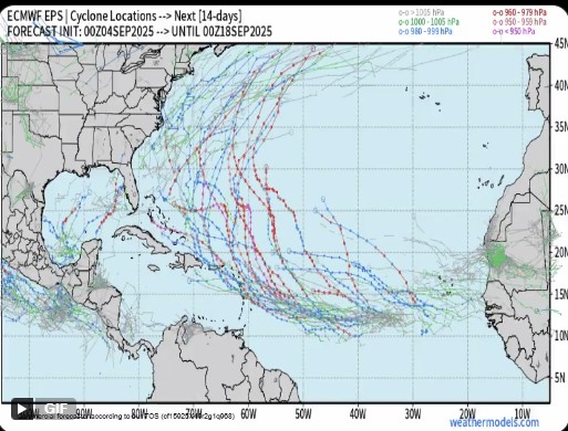
Operationals see E Carib and CONUS but ensembles favor recurve/Bermuda:


0 likes
Emily '87, Felix '95, Gert '99, Fabian '03, Humberto '19, Paulette '20, Teddy '20, Fiona '22, Lee '23, Ernesto '24, Humberto/Imelda '25
-
Hypercane_Kyle

- Category 5
- Posts: 3465
- Joined: Sat Mar 07, 2015 7:58 pm
- Location: Cape Canaveral, FL
Re: ATL: INVEST 91L - Models
The delayed development is definitely throwing the models for a loop. I would not be surprised if this one ends up in the Caribbean.
0 likes
My posts are my own personal opinion, defer to the National Hurricane Center (NHC) and other NOAA products for decision making during hurricane season.
-
TomballEd
- Category 5
- Posts: 1317
- Age: 62
- Joined: Wed Aug 16, 2023 4:52 pm
- Location: Spring/Klein area, not Tomball
Re: ATL: INVEST 91L - Models
Fox Weather apparently develops probs from a consensus of US and Euro ensembles and Google. Highest probs from the Fox consensus model points towards the NE Caribbean.
https://x.com/bryannorcrosstv/status/1963596128080859145
https://x.com/bryannorcrosstv/status/1963596128080859145
0 likes
Re: ATL: INVEST 91L - Models
Most 6z GFS ensembles still recurve it past the islands. However a few don't which is the biggest change on the 6z set. Something to watch, but I'm not overly concerned much yet (despite the operationals) for the US anyway -- Bermuda is different as is the Caribbean (see Euro ensembles). Only a few GFS ensembles show the leewards.
One thing on the euro and especially the google deep mind ensembles, it's a lot weaker. The google ones basically kill it off in the Caribbean.
6z Euro ensembles are much more a threat to the Caribbean

One thing on the euro and especially the google deep mind ensembles, it's a lot weaker. The google ones basically kill it off in the Caribbean.
6z Euro ensembles are much more a threat to the Caribbean
Last edited by BobHarlem on Thu Sep 04, 2025 9:50 am, edited 1 time in total.
2 likes
-
jlauderdal
- S2K Supporter

- Posts: 7240
- Joined: Wed May 19, 2004 5:46 am
- Location: NE Fort Lauderdale
- Contact:
Re: ATL: INVEST 91L - Models
Hypercane_Kyle wrote:The delayed development is definitely throwing the models for a loop. I would not be surprised if this one ends up in the Caribbean.
Google AI wasn't thrown for a loop; it liked that track from the start. Will have to watch the ensembles and see if we start getting members taking the westerly route
0 likes
Re: ATL: INVEST 91L - Models
Using Dvorak to get reasonable wind estimates for the pressure, the 0z Euro run would result in about 30 - 35 ACE from 91L in the next 360 hours. And it's still a MH at +360 hrs.
1 likes
Re: ATL: INVEST 91L - Models
jlauderdal wrote:Hypercane_Kyle wrote:The delayed development is definitely throwing the models for a loop. I would not be surprised if this one ends up in the Caribbean.
Google AI wasn't thrown for a loop; it liked that track from the start. Will have to watch the ensembles and see if we start getting members taking the westerly route
Deep mind also poofs it in the Caribbean.
0 likes
-
TomballEd
- Category 5
- Posts: 1317
- Age: 62
- Joined: Wed Aug 16, 2023 4:52 pm
- Location: Spring/Klein area, not Tomball
Re: ATL: INVEST 91L - Models
I assume the GFS has had improvements since then, but it used to be common for the model to break down the ridging to quickly. Ike was a an interesting example of this. I can't get the animation loaded, but right up to the end, Ike was always W of the NHC forecast, which is heavily influences by the GFS, its ensembles, and hurricane models using GFS initial and boundary conditions. Just one example. As I said, maybe this has been fixed in the 17 years since.

0 likes
-
SFLcane

- S2K Supporter
- Posts: 10281
- Age: 48
- Joined: Sat Jun 05, 2010 1:44 pm
- Location: Lake Worth Florida
Re: ATL: INVEST 91L - Models
BobHarlem wrote:jlauderdal wrote:Hypercane_Kyle wrote:The delayed development is definitely throwing the models for a loop. I would not be surprised if this one ends up in the Caribbean.
Google AI wasn't thrown for a loop; it liked that track from the start. Will have to watch the ensembles and see if we start getting members taking the westerly route
Deep mind also poofs it in the Caribbean.
Just too small for the model to resolve at the moment.
1 likes
-
TomballEd
- Category 5
- Posts: 1317
- Age: 62
- Joined: Wed Aug 16, 2023 4:52 pm
- Location: Spring/Klein area, not Tomball
Re: ATL: INVEST 91L - Models
BobHarlem wrote:jlauderdal wrote:Hypercane_Kyle wrote:The delayed development is definitely throwing the models for a loop. I would not be surprised if this one ends up in the Caribbean.
Google AI wasn't thrown for a loop; it liked that track from the start. Will have to watch the ensembles and see if we start getting members taking the westerly route
Deep mind also poofs it in the Caribbean.
The Graveyard becomes less deadly the deeper into Autumn the season goes, as the low over N. South America slowly weakens. A closed circulation would resist the loss of surface convergence caused by the accelerating trades. 10 days out, when the system would be entering the Caribbean, if it entered the Caribbean, shear peaks below 20 knots. Not favorable for strengthening but not enough to quickly shear apart a closed low especially since ensemble PW is near normal at that time across the Caribbean.

1 likes
-
SFLcane
- S2K Supporter
- Posts: 10281
- Age: 48
- Joined: Sat Jun 05, 2010 1:44 pm
- Location: Lake Worth Florida
Re: ATL: INVEST 91L - Models
Just some specuation on my part but I had not noticed this but the long range eps does have some members bending west a la the gfs. Those westward members might smooth out in time just north of the caribbean
2 likes
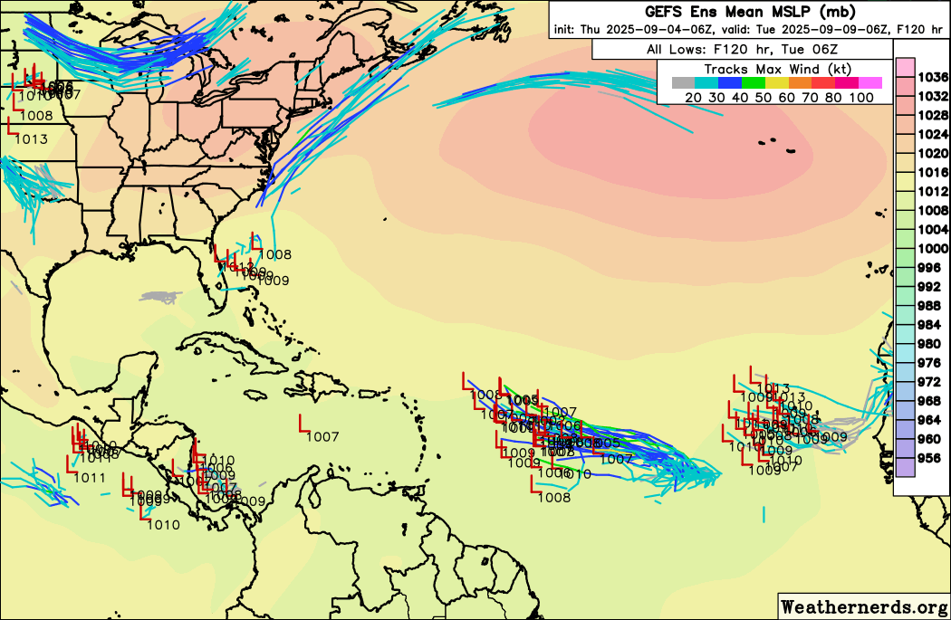
Re: ATL: INVEST 91L - Models
SFLcane wrote:Just some specuation on my part but I had not noticed this but the long range eps does have some members bending west ala gfs. Those westward members might smooth out in time just north of the caribbean
https://i.postimg.cc/4Nh9XntD/nnn.jpg
This EPS and other runs still strongly favor either a safe recurve from Conus or it staying weak or dissipating for those that stay further south and go into or near the Caribbean. So, there’s still a long ways to go before this would possibly be considered a significant threat to the Conus. Also, the threat is currently still higher for the NE Caribbean due to those members that stay further S. I’m assuming you largely agree with all of this. If not, please tell me where you disagree.
But even so, Erin did come in 200 miles/3 degrees of longitude further W than forecasted by the NHC and models 4 days earlier.
Last edited by LarryWx on Thu Sep 04, 2025 10:32 am, edited 3 times in total.
1 likes
Personal Forecast Disclaimer:
The posts in this forum are NOT official forecasts and should not be used as such. They are just the opinion of the poster and may or may not be backed by sound meteorological data. They are NOT endorsed by any professional institution or storm2k.org. For official information, please refer to the NHC and NWS products.
The posts in this forum are NOT official forecasts and should not be used as such. They are just the opinion of the poster and may or may not be backed by sound meteorological data. They are NOT endorsed by any professional institution or storm2k.org. For official information, please refer to the NHC and NWS products.
-
TomballEd
- Category 5
- Posts: 1317
- Age: 62
- Joined: Wed Aug 16, 2023 4:52 pm
- Location: Spring/Klein area, not Tomball
Re: ATL: INVEST 91L - Models
This seems about right. Convection is waning now, we'll see how much it comes back tonight. Enough convection might close the low.
https://x.com/DCAreaWx/status/1963623784885232101
https://x.com/DCAreaWx/status/1963623784885232101
1 likes
Re: ATL: INVEST 91L - Models
12z ICON run. The wind speed has been added and is based on the Dvorak relation of the modelled pressure. Remains an invest or borderline TD for the next 2 - 3 days and then develops into a TS. Further south than 00z ICON by about 2 degrees at the end of the run. About halfway between 06z GFS (which is more north) and 00z Euro (which is more south).
Time (hr) / Pressure (mb) / Wind speed (kt)
Peak intensity = 952 mb / 110 kt (+174hr)
Total ACE = 12.0
00 / 1013 / -
06 / 1010 / -
12 / 1012 / -
18 / 1009 / 30
24 / 1011 / -
30 / 1009 / 30
36 / 1011 / -
42 / 1009 / 30
48 / 1010 / -
54 / 1008 / 30 - TD
60 / 1009 / 30
66 / 1006 / 35 - TS
72 / 1007 / 35
78 / 1002 / 40
84 / 1001 / 45
90 / 995 / 55
96 / 993 / 55
102 / 988 / 65 - C1
108 / 986 / 65
114 / 981 / 75
120 / 986 / 65
126 / 983 / 70
132 / 978 / 80
138 / 977 / 80
144 / 968 / 90 - C2
150 / 963 / 100 - C3
156 / 965 / 95
162 / 953 / 110
168 / 957 / 105
174 / 952 / 110
180 / 960 / 100
2 likes
Re: ATL: INVEST 91L - Models
kevin wrote:12z ICON run. The wind speed has been added and is based on the Dvorak relation of the modelled pressure. Remains an invest or borderline TD for the next 2 - 3 days and then develops into a TS. Further south than 00z ICON by about 2 degrees at the end of the run. About halfway between 06z GFS (which is more north) and 00z Euro (which is more south).
[...]
https://i.imgur.com/wO0jjOt.gif
The trailing TS that 12z ICON shows behind the MH 91L is pure gold (even though, of course, it has happened before). It will most likely be gone in future runs, however.
0 likes
TC naming lists: retirements and intensity
Most aggressive Advisory #1's in North Atlantic (cr. kevin for starting the list)
Most aggressive Advisory #1's in North Atlantic (cr. kevin for starting the list)
Who is online
Users browsing this forum: No registered users and 66 guests