Tropical Wave over the Central Caribbean
Moderator: S2k Moderators
Forum rules

The posts in this forum are NOT official forecasts and should not be used as such. They are just the opinion of the poster and may or may not be backed by sound meteorological data. They are NOT endorsed by any professional institution or STORM2K. For official information, please refer to products from the National Hurricane Center and National Weather Service.


Re: Tropical Wave near 45W
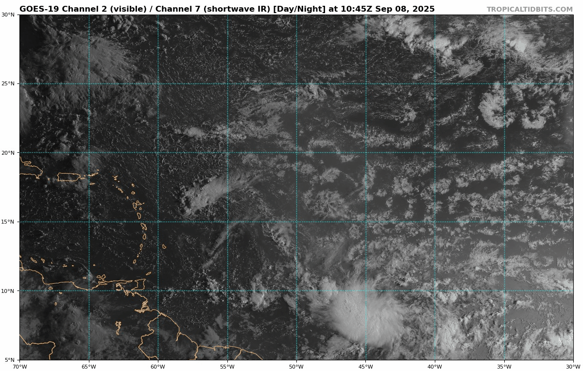
colbroe wrote:There is an area of thunderstorms around 10N 40W.
Yep, I noticed that this evening. How much of it is DMAX related I don't know but water vapor seems to verify the area around it is moisening up. Also evident are west winds at some level. We'll have to wait till tomorrow morning and see whether convection has maintained itself. If I were pressed for an very rough central point, I'd guess around 8N & 43W.
This is the time of year where we've seem tropical cyclones develop insanely fast so one never knows.
0 likes
Andy D
(For official information, please refer to the NHC and NWS products.)
(For official information, please refer to the NHC and NWS products.)
-
AJC3

- Admin

- Posts: 4156
- Age: 62
- Joined: Tue Aug 31, 2004 7:04 pm
- Location: Ballston Spa, New York
- Contact:
Re: Tropical Wave near 45W
Tropical Weather Discussion
NWS National Hurricane Center Miami FL
0015 UTC Mon Sep 8 2025
...TROPICAL WAVES...
<snip>
A central Atlantic tropical wave is near 45W from 17N southward,
and moving west at 5 to 10 kt. Scattered moderate convection is
noted from 03N to 11N between 37W and 45W.
NWS National Hurricane Center Miami FL
0015 UTC Mon Sep 8 2025
...TROPICAL WAVES...
<snip>
A central Atlantic tropical wave is near 45W from 17N southward,
and moving west at 5 to 10 kt. Scattered moderate convection is
noted from 03N to 11N between 37W and 45W.
Multi-channel satellite loop...

Here's something neat I just tried doing for the first time. In the past, the ASCAT METOP B and C pass swaths usually haven't lent themselves to being merged because there was significant coverage overlap. Apparently, someone at NESDIS (or more likely EUMETSAT, since the METOPs are theirs) must have noticed this as well, and it looks like the orbit path of one of the two birds was adjusted so that the swaths now complement each other very well! This is a mesh I put together of the 08/23:44 UTC and 09/00:34 swaths. I thought it was pretty cool...
edit: It's not exactly what I thought. I rec'd this reply from a reliable source when I asked about it in a TC discussion group :
"METOP-B's LTAN (local time ascending node) has been allowed to drift so you are seeing the beneficial effects of that in the tropics. It's LTAN will continue to be allowed to drift until EUMETSAT deorbits METOP-B in late 2027 or 2028.

3 likes

Re: Tropical Wave near 45W
Not sure if this crashes into South America or becomes the storm GFS spins up in the West Carib and moves into the GoM.
0 likes
-
tropicwatch

- Category 5

- Posts: 3427
- Age: 62
- Joined: Sat Jun 02, 2007 10:01 am
- Location: The Villages, Florida
- Contact:
Re: Tropical Wave near 45W
Still seems to be a broad circulation but not seeing much vorticity close to the surface at this time.
0 likes
Tropicwatch
Agnes 72', Eloise 75, Elena 85', Kate 85', Charley 86', Florence 88', Beryl 94', Dean 95', Erin 95', Opal 95', Earl 98', Georges 98', Ivan 2004', Arlene 2005', Dennis 2005', Ida 2009' Debby 2012' Irma 2017' Michael 2018'
Agnes 72', Eloise 75, Elena 85', Kate 85', Charley 86', Florence 88', Beryl 94', Dean 95', Erin 95', Opal 95', Earl 98', Georges 98', Ivan 2004', Arlene 2005', Dennis 2005', Ida 2009' Debby 2012' Irma 2017' Michael 2018'
-
TomballEd
- Category 5
- Posts: 1318
- Age: 62
- Joined: Wed Aug 16, 2023 4:52 pm
- Location: Spring/Klein area, not Tomball
Re: Tropical Wave near 45W
I'm not seeing a lot of model support. It does look good, however.

1 likes
Re: Tropical Wave near 45W
Something is there. Its firing in very low shear.
Low-level vorticity looks broad on CIMSS.
Low-level vorticity looks broad on CIMSS.
0 likes
Re: Tropical Wave near 45W
Alot of convergence is showing up on MIMIC-TPW
https://tropic.ssec.wisc.edu/real-time/ ... anim=html5
https://tropic.ssec.wisc.edu/real-time/ ... anim=html5
0 likes
-
AJC3
- Admin
- Posts: 4156
- Age: 62
- Joined: Tue Aug 31, 2004 7:04 pm
- Location: Ballston Spa, New York
- Contact:
Re: Tropical Wave near 45W
GCANE wrote:This was 91L.
They took it down too quick.
This isn't 91L, and even if it was, saying it was taken down too quick is an overly harsh assessment, given what it looked like the past 48 hours.
This area may have been "sorta-kinda" spawned by convergence near the ITCZ that was enhanced by inflow on the southern flank of 91L, however the badly deformed vortlobe associated with that ex-Invest is NNW of this area by a good 5 degrees. This mess is centered all the way down around 8N. In the first few images of the time lapse I posted, you can see the carcass of what was once 91L.
Here's an annotated still from that loop. Barbados (lat 13.2N) is the small white blip at the far left of the image.
edit: "This wave" was probably a poor choice of notation on may part, since the wave axis extends well north of there. "This area of disturbed weather" would have been better.

3 likes
Re: Tropical Wave near 45W
AJC3 wrote:GCANE wrote:This was 91L.
They took it down too quick.
This isn't 91L, and even if it was, saying it was taken down too quick is an overly harsh assessment, given what it looked like the past 48 hours.
This area may have been "sorta-kinda" spawned by convergence near the ITCZ that was enhanced by inflow on the southern flank of 91L, however the badly deformed vortlobe associated with that ex-Invest is NNW of this area by a good 5 degrees. This mess is centered all the way down around 8N. In the first few images of the time lapse I posted, you can see the carcass of what was once 91L.
Here's an annotated still from that loop. Barbados (lat 13.2N) is the small white blip at the far left of the image.
https://i.imgur.com/eYYLazU.png
Maybe I was wrong, but I was always tracking the LL Vort for 91L which was a few degrees in latitude south of the convection.
But was at the same longitude.
This vort is converging in the ITCZ and gaining convection.
0 likes
Re: Tropical Wave near 45W
ICON basically doesn't move the surface low for the next 100 hours.
1 likes
-
AJC3
- Admin
- Posts: 4156
- Age: 62
- Joined: Tue Aug 31, 2004 7:04 pm
- Location: Ballston Spa, New York
- Contact:
Re: Tropical Wave near 45W
GCANE wrote:AJC3 wrote:GCANE wrote:This was 91L.
They took it down too quick.
This isn't 91L, and even if it was, saying it was taken down too quick is an overly harsh assessment, given what it looked like the past 48 hours.
This area may have been "sorta-kinda" spawned by convergence near the ITCZ that was enhanced by inflow on the southern flank of 91L, however the badly deformed vortlobe associated with that ex-Invest is NNW of this area by a good 5 degrees. This mess is centered all the way down around 8N. In the first few images of the time lapse I posted, you can see the carcass of what was once 91L.
Here's an annotated still from that loop. Barbados (lat 13.2N) is the small white blip at the far left of the image.
https://i.imgur.com/eYYLazU.png
Maybe I was wrong, but I was always tracking the LL Vort for 91L which was a few degrees in latitude south of the convection.
But was at the same longitude.
This vort is converging in the ITCZ and gaining convection.
I went back and looked at the H85 vort init panels, and, as you said, a good chunk of the vorticity from 91L took a SW dive into the ITCZ, while a smaller portion sped westward out to the position I annotated in my post.
It's pretty clear to see in the loop below. I stand corrected...

1 likes
Re: Tropical Wave near 45W
Too spread out, I don't see how this gets together. Same problem as other waves this year (99l for example), one layer looks ok, the others horrible and that's the case here too. Elements are just too close to each other so it behaves like a long axis, preventing circulation forming.

Last edited by BobHarlem on Mon Sep 08, 2025 7:05 am, edited 1 time in total.
1 likes
Re: Tropical Wave near 45W
AJC3 wrote:GCANE wrote:AJC3 wrote:
This isn't 91L, and even if it was, saying it was taken down too quick is an overly harsh assessment, given what it looked like the past 48 hours.
This area may have been "sorta-kinda" spawned by convergence near the ITCZ that was enhanced by inflow on the southern flank of 91L, however the badly deformed vortlobe associated with that ex-Invest is NNW of this area by a good 5 degrees. This mess is centered all the way down around 8N. In the first few images of the time lapse I posted, you can see the carcass of what was once 91L.
Here's an annotated still from that loop. Barbados (lat 13.2N) is the small white blip at the far left of the image.
https://i.imgur.com/eYYLazU.png
Maybe I was wrong, but I was always tracking the LL Vort for 91L which was a few degrees in latitude south of the convection.
But was at the same longitude.
This vort is converging in the ITCZ and gaining convection.
I went back and looked at the H85 vort init panels, and, as you said, a good chunk of the vorticity from 91L took a SW dive into the ITCZ, while a smaller portion sped westward out to the position I annotated in my post.
It's pretty clear to see in the loop below. I stand corrected...
https://i.imgur.com/jLfj7ds.gif
I remember last week when this was tagged an invest, that the convection was driven by a shear gradient.
That is why I never associated 91L with the convection, rather with the low-level vort.
0 likes
Re: Tropical Wave near 45W
Waves don't become stationary.
This is moving due west and approaching 50W.
Amazon looks ready.
https://tropic.ssec.wisc.edu/real-time/ ... anim=html5
This is moving due west and approaching 50W.
Amazon looks ready.
https://tropic.ssec.wisc.edu/real-time/ ... anim=html5
0 likes

Re: Tropical Wave near 45W
With the very low latitude, wouldn't this simply crash into Central America even if it unexpectedly develops?
0 likes
TC naming lists: retirements and intensity
Most aggressive Advisory #1's in North Atlantic (cr. kevin for starting the list)
Most aggressive Advisory #1's in North Atlantic (cr. kevin for starting the list)
-
Category5Kaiju

- Category 5
- Posts: 4345
- Joined: Thu Dec 24, 2020 12:45 pm
- Location: Seattle during the summer, Phoenix during the winter
Re: Tropical Wave near 45W
Teban54 wrote:With the very low latitude, wouldn't this simply crash into Central America even if it unexpectedly develops?
https://i.postimg.cc/BQtNS6yM/goes19-vis-swir-catl.gif
Yup. Remember Bonnie from 2022?
0 likes
Unless explicitly stated, all information in my posts is based on my own opinions and observations. Tropical storms and hurricanes can be extremely dangerous. Refer to an accredited weather research agency or meteorologist if you need to make serious decisions regarding an approaching storm.
Re: Tropical Wave near 45W
Teban54 wrote:With the very low latitude, wouldn't this simply crash into Central America even if it unexpectedly develops?
https://i.postimg.cc/BQtNS6yM/goes19-vis-swir-catl.gif
I could find only 4 TCs that hit N SA from near or just below 10N going back to 1851 and died: 1 in June, 1 in July, and 2 in Aug. So, it’s an exceedingly rare occurrence for a TC to form that far S and then hit/die due to SA. Then again, only 4 did so and survived: 2 in June, 1 in Aug, and 1 in Sep. So, it’s exceedingly rare for any TC to both form that far S and to hit SA: only 8! So, I’m not expecting a TC out of this unless it forms and goes N of SA like Bonnie of 2022.
1 likes
Personal Forecast Disclaimer:
The posts in this forum are NOT official forecasts and should not be used as such. They are just the opinion of the poster and may or may not be backed by sound meteorological data. They are NOT endorsed by any professional institution or storm2k.org. For official information, please refer to the NHC and NWS products.
The posts in this forum are NOT official forecasts and should not be used as such. They are just the opinion of the poster and may or may not be backed by sound meteorological data. They are NOT endorsed by any professional institution or storm2k.org. For official information, please refer to the NHC and NWS products.
-
Stratton23
- Category 5
- Posts: 3574
- Joined: Fri Jul 21, 2023 10:59 pm
- Location: Katy, Tx
Re: Tropical Wave SE of the Windward Islands
12z EPS has a couple members that actually try to develop this in the caribbean lol
0 likes
Who is online
Users browsing this forum: Kingarabian, Ulf and 168 guests