Tropical Wave East of the Windward Islands (Is Invest 98L)
Moderator: S2k Moderators
Forum rules

The posts in this forum are NOT official forecasts and should not be used as such. They are just the opinion of the poster and may or may not be backed by sound meteorological data. They are NOT endorsed by any professional institution or STORM2K. For official information, please refer to products from the National Hurricane Center and National Weather Service.

Tropical Wave East of the Windward Islands (Is Invest 98L)
Models have been going back and forth on this with the GFS in particular bombing this out. The wave itself looks very healthy coming off Africa, this will be a lengthy thread.
3 likes


Re: Tropical Wave in the far Eastern Atlantic
Zonacane wrote:Models have been going back and forth on this with the GFS in particular bombing this out. The wave itself looks very healthy coming off Africa, this will be a lengthy thread.
Model support overall has dropped with the Icon, UK, and Euro dropping it. The CMC and GFS/GEFS though still have it. The EPS still has moderate support but now not til the SW Carib.
0 likes
Personal Forecast Disclaimer:
The posts in this forum are NOT official forecasts and should not be used as such. They are just the opinion of the poster and may or may not be backed by sound meteorological data. They are NOT endorsed by any professional institution or storm2k.org. For official information, please refer to the NHC and NWS products.
The posts in this forum are NOT official forecasts and should not be used as such. They are just the opinion of the poster and may or may not be backed by sound meteorological data. They are NOT endorsed by any professional institution or storm2k.org. For official information, please refer to the NHC and NWS products.
-
WeatherBoy2000
- Category 1

- Posts: 463
- Joined: Mon Apr 10, 2023 9:29 am
Re: Tropical Wave in the far Eastern Atlantic
LarryWx wrote:Zonacane wrote:Models have been going back and forth on this with the GFS in particular bombing this out. The wave itself looks very healthy coming off Africa, this will be a lengthy thread.
Model support overall has dropped with the Icon, UK, and Euro dropping it. The CMC and GFS/GEFS though still have it. The EPS still has moderate support but not til the SW Carib.
I dunno if I'd say that the icon's dropped it, the latest 0z run seemed to be in the process of developing it in the Caribbean before the run ended.
0 likes
Re: Tropical Wave in the far Eastern Atlantic
This year has had so many mixed model runs for MDR systems it's hard to believe anything until a TS develops. Euro op and AI not developing it is another strong signal nothing will probably happen. I'm cool with the low impact season though.
1 likes
Re: Tropical Wave in the far Eastern Atlantic
WeatherBoy2000 wrote:LarryWx wrote:Zonacane wrote:Models have been going back and forth on this with the GFS in particular bombing this out. The wave itself looks very healthy coming off Africa, this will be a lengthy thread.
Model support overall has dropped with the Icon, UK, and Euro dropping it. The CMC and GFS/GEFS though still have it. The EPS still has moderate support but not til the SW Carib.
I dunno if I'd say that the icon's dropped it, the latest 0z run seemed to be in the process of developing it in the Caribbean before the run ended.
Yes, 0Z finally starting to have TCG near end well into Car. I was referring to 6Z, which didn’t have a TCG through 120, when it would have been just E of the Car. For many days through the 6Z of yesterday, it had TCG well before the Car. So, regardless, Icon support has dropped sharply since 6Z of 10/13.
NHC TWO still no mention.
0 likes
Personal Forecast Disclaimer:
The posts in this forum are NOT official forecasts and should not be used as such. They are just the opinion of the poster and may or may not be backed by sound meteorological data. They are NOT endorsed by any professional institution or storm2k.org. For official information, please refer to the NHC and NWS products.
The posts in this forum are NOT official forecasts and should not be used as such. They are just the opinion of the poster and may or may not be backed by sound meteorological data. They are NOT endorsed by any professional institution or storm2k.org. For official information, please refer to the NHC and NWS products.

Re: Tropical Wave in the far Eastern Atlantic
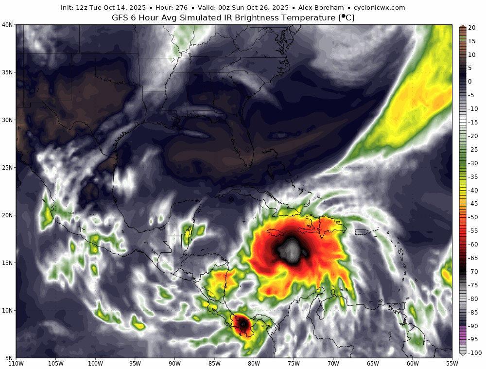
12z GFS another hurricane Mitch. Gets down to 915 mb just south of Cuba and west of JAM. Last frame at 384 hrs has it slowly drifting N-NW impacting south coast of Cuba ready to cross into the FL straits. Yes I know pure entertainment at this range.
0 likes
Re: Tropical Wave in the far Eastern Atlantic
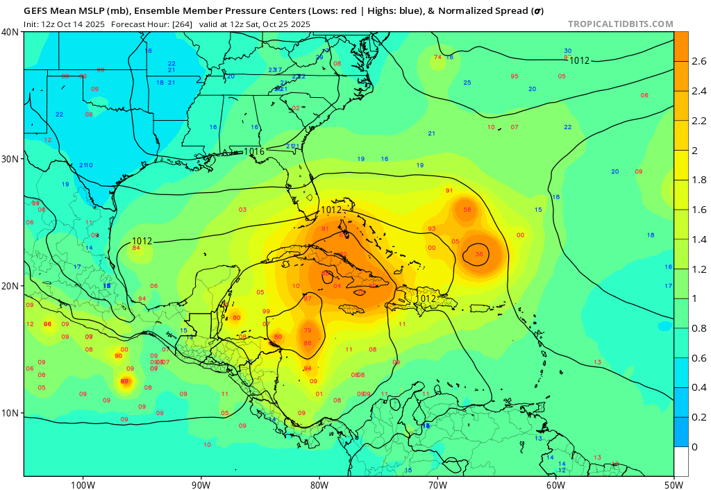
12Z:
-Icon similar to 0Z w/TD forming 168 far S Caribbean. Prior to yesterday’s 12Z, it had TCG well E of Caribbean
-UKMET no TCG thru 168, 2nd in a row; prior to these last 2, 3 runs in a row had TCG E of Car that then went into E Car
-CMC: 6th run in row w/TCG E of Car but weakest with lowest SLP 998/takes Georges-like track and weakens to <TD Cuba
-GFS 6th run in row of S Car TCG (before that was E of Car), which isn’t til 10/23-4. Turns N into C Cuba as MH 10/30
-Euro?
0 likes
Personal Forecast Disclaimer:
The posts in this forum are NOT official forecasts and should not be used as such. They are just the opinion of the poster and may or may not be backed by sound meteorological data. They are NOT endorsed by any professional institution or storm2k.org. For official information, please refer to the NHC and NWS products.
The posts in this forum are NOT official forecasts and should not be used as such. They are just the opinion of the poster and may or may not be backed by sound meteorological data. They are NOT endorsed by any professional institution or storm2k.org. For official information, please refer to the NHC and NWS products.
Re: Tropical Wave in the far Eastern Atlantic
12Z EC AIFS trended much weaker with the trade winds, allowing the wave to gain latitude and enter the Caribbean at ~14.5N. Though it still has it running into king TUTT which tears it apart. This ridging trend is definitely something to watch.
Edit: just noticed EC AIFS also trended weaker with the TUTT, likely a result of a stronger system.
Edit: just noticed EC AIFS also trended weaker with the TUTT, likely a result of a stronger system.
0 likes
Re: Tropical Wave in the far Eastern Atlantic
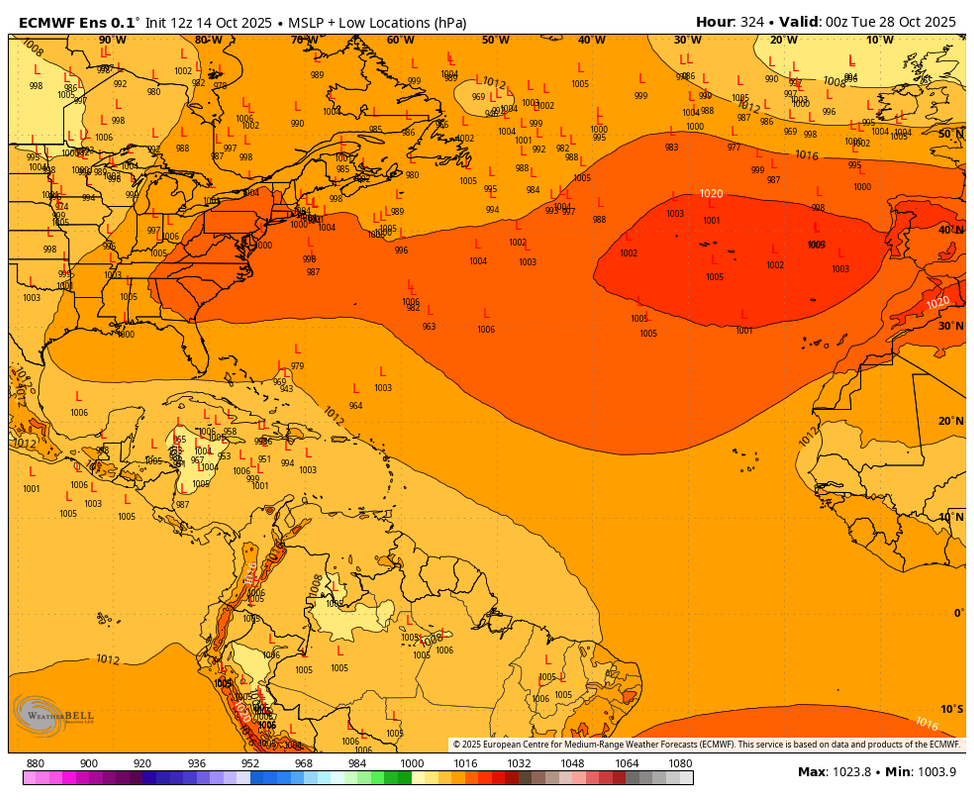
12Z Euro: back with Car TCG 10/22 like 12Z 10/13 had; Mitch-like track into C Amer as TS; weakens to TD and emerges in B of C 10/29
0 likes
Personal Forecast Disclaimer:
The posts in this forum are NOT official forecasts and should not be used as such. They are just the opinion of the poster and may or may not be backed by sound meteorological data. They are NOT endorsed by any professional institution or storm2k.org. For official information, please refer to the NHC and NWS products.
The posts in this forum are NOT official forecasts and should not be used as such. They are just the opinion of the poster and may or may not be backed by sound meteorological data. They are NOT endorsed by any professional institution or storm2k.org. For official information, please refer to the NHC and NWS products.

Re: Tropical Wave in the far Eastern Atlantic
Euro trending stronger this run.

1 likes
The following post is NOT an official forecast and should not be used as such. It is just the opinion of the poster and may or may not be backed by sound meteorological data. It is NOT endorsed by any professional institution including storm2k.org For Official Information please refer to the NHC and NWS products.
Re: Tropical Wave in the far Eastern Atlantic
blp wrote:Euro trending stronger this run.
https://i.ibb.co/KR77LZp/4446fad1-80e3-4dd5-bb05-eedaf5e465e9.gif
But Euro strongest is TS vs 70 mb lower MH GFS
0 likes
Personal Forecast Disclaimer:
The posts in this forum are NOT official forecasts and should not be used as such. They are just the opinion of the poster and may or may not be backed by sound meteorological data. They are NOT endorsed by any professional institution or storm2k.org. For official information, please refer to the NHC and NWS products.
The posts in this forum are NOT official forecasts and should not be used as such. They are just the opinion of the poster and may or may not be backed by sound meteorological data. They are NOT endorsed by any professional institution or storm2k.org. For official information, please refer to the NHC and NWS products.
Re: Tropical Wave in the far Eastern Atlantic
Here is another view.

0 likes
The following post is NOT an official forecast and should not be used as such. It is just the opinion of the poster and may or may not be backed by sound meteorological data. It is NOT endorsed by any professional institution including storm2k.org For Official Information please refer to the NHC and NWS products.
Re: Tropical Wave in the far Eastern Atlantic
LarryWx wrote:blp wrote:Euro trending stronger this run.
https://i.ibb.co/KR77LZp/4446fad1-80e3-4dd5-bb05-eedaf5e465e9.gif
But Euro strongest is TS vs 70 mb lower MH GFS
Yes I edited my post. Land interaction otherwise would have ramped up to MH.
1 likes
The following post is NOT an official forecast and should not be used as such. It is just the opinion of the poster and may or may not be backed by sound meteorological data. It is NOT endorsed by any professional institution including storm2k.org For Official Information please refer to the NHC and NWS products.
-
cycloneye

- Admin

- Posts: 149638
- Age: 69
- Joined: Thu Oct 10, 2002 10:54 am
- Location: San Juan, Puerto Rico
Re: Tropical Wave in the far Eastern Atlantic
Ends the run at BOC.

1 likes
Visit the Caribbean-Central America Weather Thread where you can find at first post web cams,radars
and observations from Caribbean basin members Click Here
and observations from Caribbean basin members Click Here
Re: Tropical Wave in the far Eastern Atlantic
2 likes
-
SFLcane

- S2K Supporter

- Posts: 10281
- Age: 48
- Joined: Sat Jun 05, 2010 1:44 pm
- Location: Lake Worth Florida
Re: Tropical Wave in the far Eastern Atlantic
Just gotta keep watching well see later this wk.
4 likes
Re: Tropical Wave in the far Eastern Atlantic
blp wrote:LarryWx wrote:blp wrote:Euro trending stronger this run.
https://i.ibb.co/KR77LZp/4446fad1-80e3-4dd5-bb05-eedaf5e465e9.gif
But Euro strongest is TS vs 70 mb lower MH GFS
Yes I edited my post. Land interaction otherwise would have ramped up to MH.
So far out, any lifting North or avoiding the Yuc could still mean hurricane
0 likes
Re: Tropical Wave in the far Eastern Atlantic
A developing storm entered the bay of Campeche in the first half of October. I know it’s highly unlikely but I’m getting flashbacks as a Floridian.
1 likes
Who is online
Users browsing this forum: JRD, TeamPlayersBlue, Ulf and 325 guests