 The posts in this forum are NOT official forecast and should not be used as such. They are just the opinion of the poster and may or may not be backed by sound meteorological data. They are NOT endorsed by any professional institution or


EURO Day 5 ...
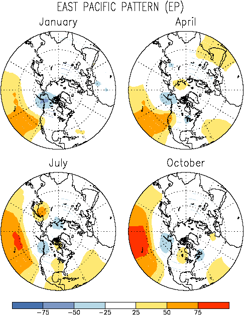
On this map, the EURO's Day 5 500mb heights output resembled a classic October East Pacific Pattern and usually is associated with a very stormy pattern ... and also would generally denote a stronger and further east displaced subtropical jet, which would tend to keep the US in a very stormy regime ... and such looks to be the case for the next week to 10 days.
Right now, as it stands, the ETA is showing a decent CAD signature at the end of the 18z run on 12/10 ... and quite strong overrunning. The precip shield looks way too weak from 500mb to surface with the amount of SW flow progged by the model aloft over damming NE winds ... The 18z GFS has absolutely no respect for the building CP high over the NE and shoves it out like an unwanted ex-girlfriend (sorry for the melodramatics, but that's occurring now) but also picks up on not one, but TWO s/w dumb-belling around each other ... which the first one shears out and is pushed northward (almost like a Fujiwhara effect as the second more potent s/w drops SE'ward). As energy from the s/w is ejected, the GFS wants to phase the two energies, but it's SFC placement doesn't exactly match what I would expect from that 500mb output ... some kind of transferrence should occur and still ride a coastal low, and what's not so clear is the amount of wedging will actually take place, but the CP HIGH has been progged much weaker than the previous runs a few days ago.
The 00z CMC run still makes the most sense to me, IMHO, with a redevelopment off the Carolina Coast as the run respects the wedging ... something that the other globals are at least, hinting at ...
Even afterwards, BOTH the CMC and GFS ensembles are hinting strongly at a very strong Eastern Trough between Dec 17th-20th ...
SF


