El Niño -- sooner or later???

Winter Weather Discussion

Moderator: S2k Moderators

Forum rules

The posts in this forum are NOT official forecast and should not be used as such. They are just the opinion of the poster and may or may not be backed by sound meteorological data. They are NOT endorsed by any professional institution or STORM2K.

Help Support Storm2K
Message
Author
User avatar
Stormsfury
Category 5
Category 5
Posts: 10549
Age: 53
Joined: Wed Feb 05, 2003 6:27 pm
Location: Summerville, SC

El Niño -- sooner or later???

#1 Postby Stormsfury » Fri Jan 02, 2004 7:27 pm

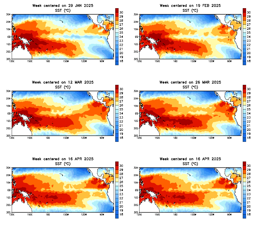
Based on this modeling from EMC ... it erodes the current SST anomalies in ENSO Regions 3 and 4 and builds it back from South America and respreading across the EQ PAC in time.

Furthermore, with the RAGING PAC JET and fast flow in the temperate zones, likewise, strong trade winds continue (along with an E QBO) across the region and decent upwelling continues to occur ...

Image

Image

Also, the equatorial PAC warm anomalies deeper down have also cooled in the past 2 months ...

ftp://ftpprd.ncep.noaa.gov/pub/cpc/wd52 ... kxzteq.gif

SF
0 likes   

Anonymous

#2 Postby Anonymous » Fri Jan 02, 2004 7:30 pm

Uh-Oh......................does this mean we will have a mild winter?

Oh noooooooooooooooooooo!!


JEB
0 likes   

User avatar
Stormsfury
Category 5
Category 5
Posts: 10549
Age: 53
Joined: Wed Feb 05, 2003 6:27 pm
Location: Summerville, SC

#3 Postby Stormsfury » Fri Jan 02, 2004 7:31 pm

Jeb wrote:Uh-Oh......................does this mean we will have a mild winter?

Oh noooooooooooooooooooo!!

JEB


Basically put, El Niño will NOT be a factor this winter.

SF
0 likes   

Anonymous

#4 Postby Anonymous » Fri Jan 02, 2004 7:33 pm

IMMENSE RELIEF floods all over JEB!!!!!

The raging Pac Jet is enough!! El Nino..........now THAT'S something NO ONE needs!!


-JEB
0 likes   

User avatar
Stormsfury
Category 5
Category 5
Posts: 10549
Age: 53
Joined: Wed Feb 05, 2003 6:27 pm
Location: Summerville, SC

#5 Postby Stormsfury » Fri Jan 02, 2004 7:36 pm

Jeb wrote:IMMENSE RELIEF floods all over JEB!!!!!

The raging Pac Jet is enough!! El Nino..........now THAT'S something NO ONE needs!!


-JEB


Well, actually 2002-2003 wasn't too bad with a WEAK EL Niño?
0 likes   

Anonymous

#6 Postby Anonymous » Fri Jan 02, 2004 7:39 pm

Stormsfury wrote:
Jeb wrote:IMMENSE RELIEF floods all over JEB!!!!!

The raging Pac Jet is enough!! El Nino..........now THAT'S something NO ONE needs!!


-JEB


Well, actually 2002-2003 wasn't too bad with a WEAK EL Niño?


Please SF, now don't start wishing for an El Nino......that's something the East does not need!!! We'd be living in Boats for crying out loud! lol


-JEB
0 likes   

User avatar
Stormsfury
Category 5
Category 5
Posts: 10549
Age: 53
Joined: Wed Feb 05, 2003 6:27 pm
Location: Summerville, SC

#7 Postby Stormsfury » Fri Jan 02, 2004 7:40 pm

Jeb wrote:
Stormsfury wrote:
Jeb wrote:IMMENSE RELIEF floods all over JEB!!!!!

The raging Pac Jet is enough!! El Nino..........now THAT'S something NO ONE needs!!


-JEB


Well, actually 2002-2003 wasn't too bad with a WEAK EL Niño?


Please SF, now don't start wishing for an El Nino......that's something the East does not need!!! We'd be living in Boats for crying out loud! lol

-JEB


However, last year's overall setup was completely different in regards to the QBO for one, no two years are EXACTLY the same.

SF
0 likes   

User avatar
FLguy
Professional-Met
Professional-Met
Posts: 799
Joined: Mon Dec 29, 2003 5:36 pm
Location: Daytona Beach FL
Contact:

#8 Postby FLguy » Fri Jan 02, 2004 8:06 pm

Yes this is very true and indeed has some support from the AGCM climate model.

Image

Notice how the warm pool shifts eastward overtime and the warm plume becomes re-established in the eastern equatorial pacific.

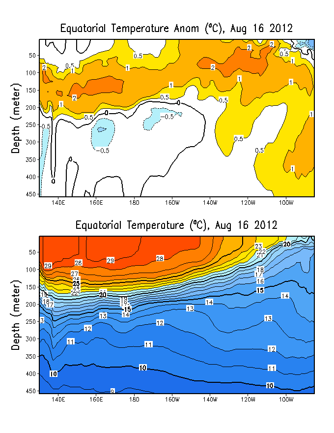
The following figure shows current sub-surface water temperature means and anomalies:
Image

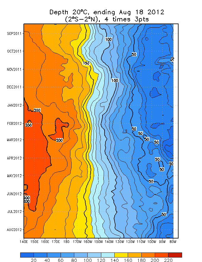
The strongest sub-surface warm anomalies continue to be located in the western tropical pacific...Notice also the relatively shallow depth of the +20C isotherm across the eastern pacific Nino regions which is NOT favorable for the eastward expansion of the warm pool in the western equatorial regions.

heres another look at the 20C isotherm depth in a time-longitude section of the equatorial pacific:
Image

Typically weak El Nino events in the long-term cold cycle of the PDO are centered further west in the Equatorial pacific as a function of the large scale SSTA set up in the paciifc during the cold phase of the PDO.

the following figures shows the PDO phases in relation to El Nino and La Nina events:

http://tao.atmos.washington.edu/pdo/img ... m_cool.jpg

http://tao.atmos.washington.edu/pdo/img ... _cool2.jpg

Notice who the SSTA configuration particular to El Nino events corresponds well to the PDO long term warm phase. the same as the SSTA configuration particular to La Nina is most consistent with the PDO long term cold phase.

One must also understand the PDO displays quite a bit of interseasonal variability --- thus much like now...one can have a positive (warm) phase PDO for a short period of tie within the long-term...decadal and multi-decadal scale cold cycles.

Currently the PDO is in a short term warm cycle within the longer term cold cycle (entered in 1998). as a result --- this is much of the reason why last winters moderate El Nino was located further WEST in the Nino 3.0... 3.4 and 4.0 regions as compared to a classic El Nino in the long-term warm phase which is normally centered closest to the South American Coast (in the Nino 1+2 region).

For this reason im NOT convined that an El Nino the likes of wha the EMC model has been indicating can develop this spring given the PDO phase. Time will tell what IF any effect it will have on the atlantic tropical season.

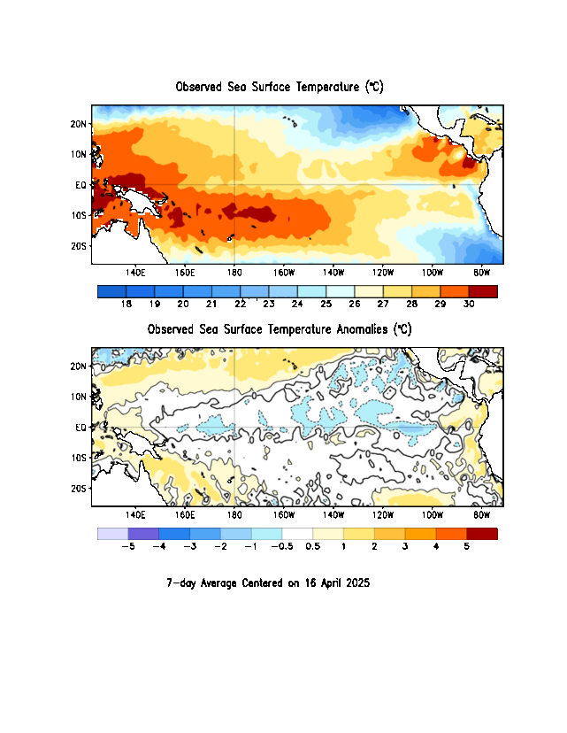
At the present time...we are dealing with slightly warm ENSO neutral conditions. the ONLY area in the tropical paciifc where El Nino critera (+0.5C) has been acheived for any sustainable amouint of time is in the NINO 4.0 region near the dateline:
Image

the eastern PAC NINO regions remain near normal.

IF the warm plume should begin to develop near the south american coast this spring...one may be able to expect MJO activity to decrease...and be LESS of a moderating factor on the 2004 tropical season.

as for the present with the current SSTA set-up the fluctuations in the MJO will continue to make for much variability in the PAC jet the remainder of the winter. At this point given this and the QBO...I doubt we will see the PAC jet relax anytime soon.

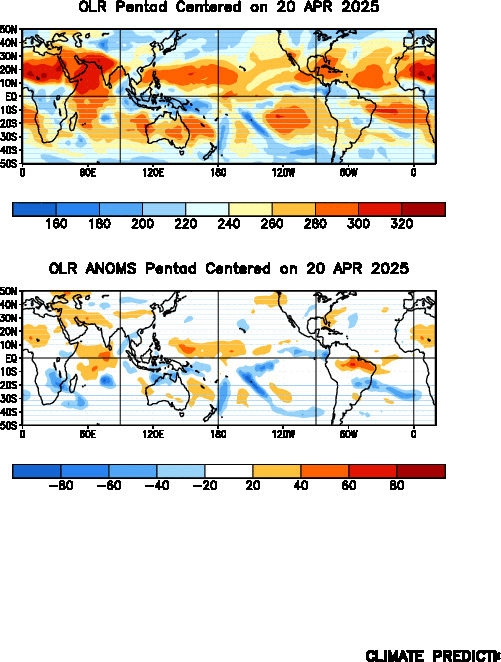
the final figure shows Global OLR anomalies:
Image

Notice the very low OLR values across the western tropical pacific which correspond well to increased convection and above normal precipitation.
Last edited by FLguy on Fri Jan 02, 2004 8:49 pm, edited 1 time in total.
0 likes   

Anonymous

#9 Postby Anonymous » Fri Jan 02, 2004 8:13 pm

If the pac jet doesn't relax anytime soon, then that means the cold outbreak can't happen, or that it will be a mildly cold outbreak. As long as that blasted pac jet keeps on blasting, we'll never see any major cold outbreaks and thus little or no snow. Oh well.

I really Hate that d@mned blasted pac jet.

-Jeb
0 likes   

User avatar
FLguy
Professional-Met
Professional-Met
Posts: 799
Joined: Mon Dec 29, 2003 5:36 pm
Location: Daytona Beach FL
Contact:

#10 Postby FLguy » Fri Jan 02, 2004 8:20 pm

Jeb wrote:If the pac jet doesn't relax anytime soon, then that means the cold outbreak can't happen, or that it will be a mildly cold outbreak. As long as that blasted pac jet keeps on blasting, we'll never see any major cold outbreaks and thus little or no snow. Oh well.

I really Hate that d@mned blasted pac jet.

-Jeb


NO....dont you get it --- the fluctuations in the MJO will control the short term tendencies of the PAC jet. A Positive MJO (dry phase) would cause the PAC jet to relax and allow for amplification.

OVERALL the PAC jet will remain active through sping with a more active MJO and as long as the QBO remains above +10. BUT that DOES NOT mean that we cannot or will not have MAJOR cold outbreaks into the CONUS.
0 likes   

Anonymous

#11 Postby Anonymous » Fri Jan 02, 2004 8:28 pm

Okay, just as long as I get my bone-chilling cold and crippling snows here in northern Virginia. Just so I get to dig snow for hours on end. Just so I get to go enjoy a beautiful jebwalk, with HUGE plowed snow piles 35 feet tall that absolutely DOMINATE the landscape!!

I want a really brutal cold frigid outbreak here in N VA. I would like to see daytime maxima struggle into the upper single digits with overnight lows in the low negative teens and dewpoints near -20 degrees. I want to go slide on sheets of ice created by water main breaks. I want to spend days and days shoveling wind-blown snow.

-JEB
0 likes   

User avatar
FLguy
Professional-Met
Professional-Met
Posts: 799
Joined: Mon Dec 29, 2003 5:36 pm
Location: Daytona Beach FL
Contact:

#12 Postby FLguy » Fri Jan 02, 2004 8:41 pm

Jeb wrote:Okay, just as long as I get my bone-chilling cold and crippling snows here in northern Virginia. Just so I get to dig snow for hours on end. Just so I get to go enjoy a beautiful jebwalk, with HUGE plowed snow piles 35 feet tall that absolutely DOMINATE the landscape!!

I want a really brutal cold frigid outbreak here in N VA. I would like to see daytime maxima struggle into the upper single digits with overnight lows in the low negative teens and dewpoints near -20 degrees. I want to go slide on sheets of ice created by water main breaks. I want to spend days and days shoveling wind-blown snow.

-JEB


alright but just one question ----- what the hell is a jebwalk
0 likes   

Anonymous

#13 Postby Anonymous » Fri Jan 02, 2004 8:53 pm

FLguy wrote:
Jeb wrote:Okay, just as long as I get my bone-chilling cold and crippling snows here in northern Virginia. Just so I get to dig snow for hours on end. Just so I get to go enjoy a beautiful jebwalk, with HUGE plowed snow piles 35 feet tall that absolutely DOMINATE the landscape!!

I want a really brutal cold frigid outbreak here in N VA. I would like to see daytime maxima struggle into the upper single digits with overnight lows in the low negative teens and dewpoints near -20 degrees. I want to go slide on sheets of ice created by water main breaks. I want to spend days and days shoveling wind-blown snow.

-JEB


alright but just one question ----- what the hell is a jebwalk


When me and all my Christian friends went to Nags Head this past October, I went on walks along the beach. I like aesthetic features like the surf, the sand, the beach cottages' architecture, and I walk for miles, blasting Christian worship songs over my CD headphones. My friends there at the beach started calling my long beach walks "jebwalks" and the name stuck. Now I term all my walking "jebwalks". There are beach jebwalks and snow-related jebwalks. When we were at Nags Head, that was when I first began correlating the Temperature/Dewpoint spreads to my jebwalks. In Nags Head in October I enjoyed 77/64 T/D spreads. This winter, I have enjoyed 31/7 T/D spread jebwalks.

One of the biggest reasons I want such horrific Siberian Outbreaks is because I want to experience a brutal -5/-32 T/D spread jebwalk. I want to walk in such ultra-frigid conditions as that and slide on all the fresh ice sheets from all the water-main breaks. We get water main breaks here in N VA in unseasonably cold weather. The water mains bust, water runs all over the place, and ice forms. Then I slide on it during one of my cold-outbreak jebwalks.


JEB
0 likes   

User avatar
FLguy
Professional-Met
Professional-Met
Posts: 799
Joined: Mon Dec 29, 2003 5:36 pm
Location: Daytona Beach FL
Contact:

#14 Postby FLguy » Fri Jan 02, 2004 8:58 pm

Jeb wrote:
FLguy wrote:
Jeb wrote:Okay, just as long as I get my bone-chilling cold and crippling snows here in northern Virginia. Just so I get to dig snow for hours on end. Just so I get to go enjoy a beautiful jebwalk, with HUGE plowed snow piles 35 feet tall that absolutely DOMINATE the landscape!!

I want a really brutal cold frigid outbreak here in N VA. I would like to see daytime maxima struggle into the upper single digits with overnight lows in the low negative teens and dewpoints near -20 degrees. I want to go slide on sheets of ice created by water main breaks. I want to spend days and days shoveling wind-blown snow.

-JEB


alright but just one question ----- what the hell is a jebwalk


When me and all my Christian friends went to Nags Head this past October, I went on walks along the beach. I like aesthetic features like the surf, the sand, the beach cottages' architecture, and I walk for miles, blasting Christian worship songs over my CD headphones. My friends there at the beach started calling my long beach walks "jebwalks" and the name stuck. Now I term all my walking "jebwalks". There are beach jebwalks and snow-related jebwalks. When we were at Nags Head, that was when I first began correlating the Temperature/Dewpoint spreads to my jebwalks. In Nags Head in October I enjoyed 77/64 T/D spreads. This winter, I have enjoyed 31/7 T/D spread jebwalks.

One of the biggest reasons I want such horrific Siberian Outbreaks is because I want to experience a brutal -5/-32 T/D spread jebwalk. I want to walk in such ultra-frigid conditions as that and slide on all the fresh ice sheets from all the water-main breaks. We get water main breaks here in N VA in unseasonably cold weather. The water mains bust, water runs all over the place, and ice forms. Then I slide on it during one of my cold-outbreak jebwalks.


JEB


Oh...ok thats pretty interesting .... im not sure if you will be enjoying a -5/-32 jebwalk .... but im sure ytou will be enjoying a VERY cold one pretty soon.
0 likes   

User avatar
FLguy
Professional-Met
Professional-Met
Posts: 799
Joined: Mon Dec 29, 2003 5:36 pm
Location: Daytona Beach FL
Contact:

#15 Postby FLguy » Fri Jan 02, 2004 9:25 pm

BTW --- for those that are unaware of what they are...here is a graphical representation of the 4 ENSO regions:

http://www.cpc.ncep.noaa.gov/products/a ... gions.html
0 likes   

User avatar
FLguy
Professional-Met
Professional-Met
Posts: 799
Joined: Mon Dec 29, 2003 5:36 pm
Location: Daytona Beach FL
Contact:

#16 Postby FLguy » Fri Jan 02, 2004 10:03 pm

and not to mention...the GFS ensembels would imply the development of a negative Western pacific oscillation (WPO) throughout the period as INTENSE blocking forms over the bering sea between alaska and eastern siberia.

Image

Which is consistent with the re-establishment of the vortex along the southwest shore of hudsons bay and much below normal heights in central canada.

the following figure shows what is normal for a +WPO ... for the negative phase of the factor...picture the inverse of what you see:

Image

as we head through the period the block will continue to retrograde eastward a low pressure takes shape in the gulf of AK

http://www.cdc.noaa.gov/map/images/ens/ ... 8_nhbg.gif
0 likes   

User avatar
FLguy
Professional-Met
Professional-Met
Posts: 799
Joined: Mon Dec 29, 2003 5:36 pm
Location: Daytona Beach FL
Contact:

#17 Postby FLguy » Fri Jan 02, 2004 10:17 pm

and this was also supported STRONGLY by the past few runs of the european
0 likes   

User avatar
Stormsfury
Category 5
Category 5
Posts: 10549
Age: 53
Joined: Wed Feb 05, 2003 6:27 pm
Location: Summerville, SC

#18 Postby Stormsfury » Fri Jan 02, 2004 11:37 pm

Which my idea of the retrogression of the blocking is strongly supported (which I discussed about several days ago as a vort lobe broke away from Western Canada and the lowering heights retrograded westward ... as demonstrated by this old loop from a couple of nights ago.

http://www.stormsfury1.com/Weather/Mode ... Loop2.html
0 likes   

User avatar
FLguy
Professional-Met
Professional-Met
Posts: 799
Joined: Mon Dec 29, 2003 5:36 pm
Location: Daytona Beach FL
Contact:

#19 Postby FLguy » Fri Jan 02, 2004 11:44 pm

Stormsfury wrote:Which my idea of the retrogression of the blocking is strongly supported (which I discussed about several days ago as a vort lobe broke away from Western Canada and the lowering heights retrograded westward ... as demonstrated by this old loop from a couple of nights ago.

http://www.stormsfury1.com/Weather/Mode ... Loop2.html


and IF the low in the gulf of alaska following the block responsible for the -WPO retrogrades westward toward the aleutian islands as the EC implies then we might be able to expect a +PNA pattern to become established later in the period.
0 likes   

rainstorm

#20 Postby rainstorm » Sat Jan 03, 2004 9:02 am

0 likes   


Return to “Winter Weather”

Who is online

Users browsing this forum: No registered users and 7 guests