As bad as they might have been...

This is the general tropical discussion area. Anyone can take their shot at predicting a storms path.

Moderator: S2k Moderators

Forum rules

The posts in this forum are NOT official forecasts and should not be used as such. They are just the opinion of the poster and may or may not be backed by sound meteorological data. They are NOT endorsed by any professional institution or STORM2K. For official information, please refer to products from the National Hurricane Center and National Weather Service.

Help Support Storm2K
Message
Author
Anonymous

As bad as they might have been...

#1 Postby Anonymous » Sun Jul 11, 2004 4:12 am

People in the United States have been extremely lucky from monster storms the past few years. Since 2000, here is what might have happened....

Hurricane Debby

As Debby looked good on late August 22, 2000 she soon fell to shear. This image shows Debby at her best:
Image

Debby continues just north of the D.R and gains strength to 105 mph, she then slams into the Turks and Cacios. It does not weaken, and as it then hits Great Inagua at 125 mph. It then, still doing a WNW track like stairs, heads into Andros Island as a 135 mph storm. Then it stikes Miami at 140 mph causing massive damage.

MORE TO COME.....
0 likes   

User avatar
Aquawind
Category 5
Category 5
Posts: 6714
Age: 62
Joined: Mon Jun 16, 2003 10:41 pm
Location: Salisbury, NC
Contact:

#2 Postby Aquawind » Sun Jul 11, 2004 6:44 am

Floydbuster you have got to find a way to use this imagination of yours to make some money!! You should be writing movie scripts for TWC and hollywood..no kidding.. :wink:

Ahh yes I can see it now..A massive cat 5 continues to grow and grow and GROW...no doubt you would be adding a few catigories above 5.. :eek: :eek:

Nothing wrong with dreaming... :)
0 likes   

User avatar
Weatherboy1
Category 5
Category 5
Posts: 1190
Age: 50
Joined: Mon Jul 05, 2004 1:50 pm
Location: Jupiter/Sarasota, FL

Debby debacle

#3 Postby Weatherboy1 » Sun Jul 11, 2004 7:29 am

Actually, with Debby, it wasn't so much shear that killed the storm. Its LLC got way too close to Hispanola (it actually was hugging the coast at one point -- I remember a recon report mentioning that fact). The 10,000-foot high mountains disrupted the high-level convection and inflow, leaving nothing but a "bald" LLC to move west toward Cuba and dissipate in the Caribbean. I remember here, the storm was big news on TV because it was forecast to be at least a Cat 2 or so heading toward Miami the morning before it got to Hispanola. But by the end of that day, I knew it was toast because I had been watching all day and saw it getting chewed up. Another problem the storm had all along -- the subtropcial ridge was so strong, Debby chugged along at something like 25 mph to the WNW so it could never get its act totally together even before Hispanola.
0 likes   

Anonymous

#4 Postby Anonymous » Sun Jul 11, 2004 4:19 pm

GFDL once took Debby down to 926 MB.
0 likes   

Josephine96

#5 Postby Josephine96 » Sun Jul 11, 2004 4:24 pm

Nice to remember the last time we had a healthy storm approaching the US lol..

Of course Isabel was potent too..
0 likes   

User avatar
HURAKAN
Professional-Met
Professional-Met
Posts: 46086
Age: 38
Joined: Thu May 20, 2004 4:34 pm
Location: Key West, FL
Contact:

#6 Postby HURAKAN » Sun Jul 11, 2004 4:56 pm

Hurricane Debby proved to be a "Mythbuster".
0 likes   

Anonymous

#7 Postby Anonymous » Sun Jul 11, 2004 5:50 pm

Hurricane Gordon showed a lot of potential. Many thought Gordon was about to explode from a weak depression into a damaging hurricane. It did explode, but stopped at 80 mph. It then made landfall at 65 mph near Cedar Key, FL. It did not look too good on satellite imagery though:

Image

Gordon MIGHT have continued to gain strength up until landfall hitting as a damaging category 2 of 100 mph.

Hurricane Joyce was a storm that everyone knew after Keith was done, would come along. Small at it's peak of 90 mph, Joyce had the potential to become a Georges like storm. But the 2000 season was the season of shear. Joyce died due to it. While it is unknown what Joyce may have done, I think that it would have come to affect the caribbean with devestating effects.
0 likes   

Anonymous

#8 Postby Anonymous » Sun Jul 11, 2004 6:12 pm

HURAKAN wrote:Hurricane Debby proved to be a "Mythbuster".


Agree...Debby was amazingly disappointing!! I hadn't heard of s2k yet then but was a member over at GOPBI and remember hearing of the govt telling all non residents of the keys to leave cuz they were anticipating having to evacuate... and local mets were covering it as it was supposed to come up and give my area some fun--but it went POOF :eek:

Code: Select all

HURRICANE DEBBY DISCUSSION NUMBER  15
NATIONAL WEATHER SERVICE MIAMI FL
5 AM EDT WED AUG 23 2000
 
DEBBY HAS AGAIN SHOWN LITTLE CHANGE IN STRENGTH OVER THE PAST 6 HR.
AN AIR FORCE RESERVE HURRICANE HUNTER AIRCRAFT FOUND A MINIMUM
PRESSURE OF 995 MB AND 74 KT FLIGHT LEVEL WINDS NORTHEAST OF THE
CENTER.  ON THIS BASIS...THE INITIAL INTENSITY REMAINS 65 KT.
WSR-88D DATA FROM SAN JUAN INDICATE A SERIES OF EYEWALL MESOVORTICES
HAVE FORMED AND THEN DISSIPATED DURING THE NIGHT...AS THE EYEWALL
CONVECTION HAS HAD TROUBLE WRAPPING MORE THAN HALFWAY AROUND THE
CENTER.  ONE NOTABLE ASPECT IS THAT A DROPSONDE IN THE EYE INDICATES
THE SURFACE CENTER MAY BE WEST OF THE 700 MB CENTER.

THE INITIAL MOTION IS 285/14.  A TWO-AIRCRAFT SYNOPTIC FLOW MISSION
TONIGHT RELEASED NUMEROUS DROPSONDES OVER THE CARIBBEAN AND WESTERN
ATLANTIC.  THESE SHOWED THAT DEBBY IS SOUTH OF A DEEP LAYER RIDGE...
AND IS ALREADY PASSING WEST OF THE WEAKNESS CAUSED BY A SHORTWAVE
TROUGH SEEN IN WATER VAPOR IMAGERY NEAR BERMUDA.  THE RIDGE SHOULD
KEEP DEBBY ON A GENERAL WEST-NORTHWEST TRACK THROUGH 48 HR.  THE
DROPSONDES HAVE CAUSED INTERESTING CHANGES IN THE MODELS.  ALL
LARGE-SCALE MODELS NOW CALL FOR A MORE WESTERLY MOTION ALONG THE
NORTH COASTS OF HISPANIOLA AND CUBA INTO THE GULF OF MEXICO.  THIS
INCLUDES THE UKMET...WHICH 12 HR AGO WAS MOVING DEBBY NORTHWARD EAST
OF FLORIDA.  IT DOES APPEAR THAT THE EASTERN U.S. TROUGH WILL
AMPLIFY SOUTHWARD BY 48 TO 72 HR.  THE QUESTION IS WILL DEBBY BE
CLOSE ENOUGH TO RESPOND TO IT?  THREE MODELS THAT SAY YES ARE LBAR
AND VICBAR...WHICH KEEP DEBBY EAST OF FLORIDA...AND THE GFDL...WHICH
TAKES IT TO NEAR THE FLORIDA KEYS.  IN VIEW OF THE SIZE OF THE
CHANGES...THERE WILL BE ONLY A SLIGHT SOUTHWARD ADJUSTMENT OF THE
FORECAST TRACK AT THIS TIME.  A MORE SUBSTANTIAL ADJUSTMENT CAN WAIT
UNTIL THERE IS MORE EVIDENCE OF WESTWARD MOTION AND MORE CONSISTENCY
IN THE MODEL RUNS.

THE DROPSONDE DATA INDICATES 10-20 KT SOUTHERLY FLOW AT 200-300 MB
UNDERCUTTING THE OUTFLOW OF DEBBY.  THIS HAS HELPED INHIBIT
INTENSIFICATION.  A COMBINATION OF SHEAR AND PROXIMITY TO HISPANIOLA
SHOULD PREVENT SIGNIFICANT STRENGTHENING FOR THE 24 HR OR SO.  AFTER
THAT...THE SHEAR MAY DECREASE AND ALLOW INTENSIFICATION.  THE SHIPS
MODEL...WHICH HAS PERFORMED WELL SO FAR...NOW TAKES DEBBY TO 81 KT
BY 72 HR.  AN EXTREME OUTLIER IS THE GFDL...WHICH HAS A 926 MB
PRESSURE AS DEBBY REACHES THE FLORIDA KEYS.  THIS LOOKS SUSPECT...AS
IT IS ALREADY STRONGER THAN REALITY AND A LOT OF DEEPENING OCCURS AS
THE MODEL STORM MOVES ALONG THE COASTS OF HISPANIOLA AND CUBA.
NEVERTHELESS...DEBBY COULD BE A DANGEROUS MAJOR HURRICANE AS IT
APPROACHES SOUTH FLORIDA.
 
FORECASTER BEVEN
 
 
FORECAST POSITIONS AND MAX WINDS
 
INITIAL     23/0900Z 19.7N  68.7W    65 KTS
12HR VT     23/1800Z 20.3N  70.7W    65 KTS
24HR VT     24/0600Z 21.0N  72.9W    65 KTS
36HR VT     24/1800Z 22.0N  75.1W    75 KTS
48HR VT     25/0600Z 23.0N  77.0W    80 KTS
72HR VT     26/0600Z 25.5N  80.0W    90 KTS


24Hours later.... What A difference a day makes :eek:

Code: Select all

TROPICAL STORM DEBBY DISCUSSION NUMBER  19
NATIONAL WEATHER SERVICE MIAMI FL
5 AM EDT THU AUG 24 2000
 
DEBBY IS AT BEST A MINIMAL TROPICAL STORM.  A NOAA HURRICANE HUNTER
AIRCRAFT FOUND A VERY POORLY DEFINED 1011 MB CENTER SOUTH OF EASTERN
CUBA WITH 35-40 KT WINDS AT 1500 FT WELL TO THE NORTHEAST.  SPORADIC
CONVECTION IS FIRING IN THIS AREA...AND THIS MAY VERY WELL MIX THOSE
WINDS DOWN TO THE SURFACE.  THE MAXIMUM WINDS WILL BE 35 KT FOR THIS
ADVISORY.

ALTHOUGH DEBBY SLIPPED A LITTLE SOUTH DURING THE NIGHT...THE INITIAL
MOTION IS NOW 270/16.  A STRONG LOW/MID LEVEL RIDGE NORTH OF THE
STORM IS PUSHING IT WESTWARD...AND THIS GENERAL MOTION SHOULD
CONTINUE FOR 24 HR.  AFTER THAT...THE STRONG UPPER LEVEL TROUGH
DEVELOPING OVER THE EASTERN U.S. SHOULD WEAKEN THE RIDGE AND
POSSIBLY ALLOW A SLOWER AND MORE NORTHWARD MOTION.  HOW FAR NORTH
WILL LIKELY DEPEND ON HOW WELL DEVELOPED DEBBY IS. THE OFFICIAL
FORECAST WILL BE SHIFTED WESTWARD FROM THE PREVIOUS PACKAGE BASED ON
THE CURRENT POSITION AND MOTION.  HOWEVER...SINCE THE GFDL...
UKMET...NOGAPS...AND AVN ARE ALL TO THE LEFT OF THE NEW FORECAST...
IT WOULD NOT BE SURPRISING IF DEBBY MOVED FURTHER WEST THAN
CURRENTLY FORECAST.
 
THE UPPER LEVEL CYCLONE/CYCLONIC SHEAR AXIS OVER THE NORTHWESTERN
CARIBBEAN IS RATHER STRONGER THAN FORECAST LAST NIGHT...AND IS
CREATING STRONG VERTICAL SHEAR OVER DEBBY.  THIS FEATURE SHOULD
PERSIST FOR 24-36 HR...THUS FURTHER WEAKENING IS LIKELY.  DEBBY
COULD WEAKEN INTO A TROPICAL WAVE DURING THIS TIME. AFTER THAT
TIME...THERE IS A CHANCE THE SHEAR WILL DECREASE DEPENDING ON
EXACTLY WHERE DEBBY IS.  A MORE NORTHWARD MOTION WOULD GET DEBBY
TANGLED IN THE WESTERLY TROUGH...WHERE WESTERLY SHEAR WOULD AT LEAST
SLOW ANY RE-DEVELOPMENT.  A MORE SOUTHERLY TRACK WOULD HAVE A BETTER
CHANCE FOR RE-DEVELOPMENT.  THE INTENSIFY FORECAST WILL CALL FOR
SLIGHT STRENGTHENING AT 48 AND 72 HR TO REFLECT THIS POSSIBILITY.
 
FORECASTER BEVEN
 
FORECAST POSITIONS AND MAX WINDS
 
INITIAL     24/0900Z 19.6N  75.9W    35 KTS
12HR VT     24/1800Z 19.7N  78.2W    30 KTS
24HR VT     25/0600Z 20.8N  80.7W    30 KTS
36HR VT     25/1800Z 22.1N  82.5W    30 KTS
48HR VT     26/0600Z 23.5N  84.0W    35 KTS
72HR VT     27/0600Z 25.5N  85.5W    40 KTS
0 likes   

Anonymous

#9 Postby Anonymous » Thu Jul 15, 2004 2:44 am

Tropical Storm Chantal fell apart due to her EXTREMELY RAPID movement. This is Chantal in the Caribbean:

Image

One forecast took Chantal to 100 mph in the NW Caribbean. Here is what might have happened...

Chantal slows down south of Hispanola, and strengthens rapidly to 80 mph. It then moves at around 15 mph to the northwest hitting Kingston, Jamacia with 100 mph winds. It then steams back up from 80 to 110 mph and enters the Gulf of Mexico. It explodes into a 125 mph hurricane, then 135 mph. It then hits Mississippi at 140 mph. (THERE WERE ALWAYS RUMORS OF CHANTAL BECOMING THE NEXT CAMILLE)

2002 brought the worse worst case situation possibility ever......

Hurricane Isidore hit the Yucatan as a 125 mph storm. It had been forecast to pull north towards Louisiana as a category4/5 hurricane after doing a small cyclonic loop over water. It was on it's way to becoming a 180 mph Gulf hurricane:
Image

Instead it did it over land causing Isidore to change unlike anything ever seen in history.
Image

Isidore might have done the loop over water, then moved north. As a TS it did hit near New Orleans, LA. It might have hit as a 160-180 mph category 5 hurricane. Thousands could have died and damage could have been well into the billions.

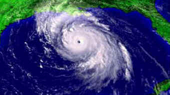
Hurricane Lili which (WE ALL KNOW HER STORY) could have then hit louisiana as a category 4 storm a week after Isidore. Billions of dollars and tons of deaths with Lili may have occured had she hit at this strength:
Image

2002 may have brought the only two major hurricanes that year out of four hurricanes inland in Louisiana a week apart killing many and doing billions in damge.
0 likes   

Anonymous

#10 Postby Anonymous » Thu Jul 15, 2004 2:28 pm

Any thoughts??
0 likes   

User avatar
Hurricanehink
S2K Supporter
S2K Supporter
Posts: 2044
Joined: Sun Nov 16, 2003 2:05 pm
Location: New Jersey

#11 Postby Hurricanehink » Thu Jul 15, 2004 6:22 pm

I have one thought. How can you even think of that?! Billions.... I'm just glad something like that hasn't happened.
0 likes   

User avatar
LAwxrgal
S2K Supporter
S2K Supporter
Posts: 1763
Joined: Tue Jul 06, 2004 1:05 pm
Location: Reserve, LA (30 mi west of NOLA)

#12 Postby LAwxrgal » Thu Jul 15, 2004 7:20 pm

Don't scare me like that! :oops:

I was in the path of both Isidore AND Lili! To think what one of those monsters would've done had they remained as strong as they were, let alone both of them. We'd still be trying to recover.

I have tremendous respect for the awesome power and ferocity of these storms.
0 likes   

Anonymous

#13 Postby Anonymous » Thu Jul 15, 2004 10:52 pm

Yes. Now what will 2004 bring???
0 likes   

User avatar
bahamaswx
Category 5
Category 5
Posts: 1545
Joined: Sat Sep 13, 2003 1:11 am
Location: Georgetown, Bahamas

#14 Postby bahamaswx » Fri Jul 16, 2004 1:58 am

Probably just another 'cane for us to all wonder "what could have been."
0 likes   


Return to “Talkin' Tropics”

Who is online

Users browsing this forum: No registered users and 115 guests