Population:
19,956 (July 2004 est.)
Geographic coordinates:
21 45 N, 71 35 W
Area:
total: 430 sq km
water: 0 sq km
land: 430 sq km
Area - comparative:
2.5 times the size of Washington, DC
Land boundaries:
0 km
Coastline:
389 km
Maritime claims - as described in UNCLOS 1982 (see Notes and Definitions):
territorial sea: 12 NM
exclusive fishing zone: 200 NM
Climate:
tropical; marine; moderated by trade winds; sunny and relatively dry
Terrain:
low, flat limestone; extensive marshes and mangrove swamps
Elevation extremes:
lowest point: Caribbean Sea 0 m
highest point: Blue Hills 49 m
Natural resources:
spiny lobster, conch
Land use:
arable land: 2.3%
permanent crops: 0%
other: 97.7% (1998 est.)
Natural hazards:
frequent hurricanes
Environment - current issues:
limited natural fresh water resources, private cisterns collect rainwater
Geography - note:
about 40 islands (eight inhabited)
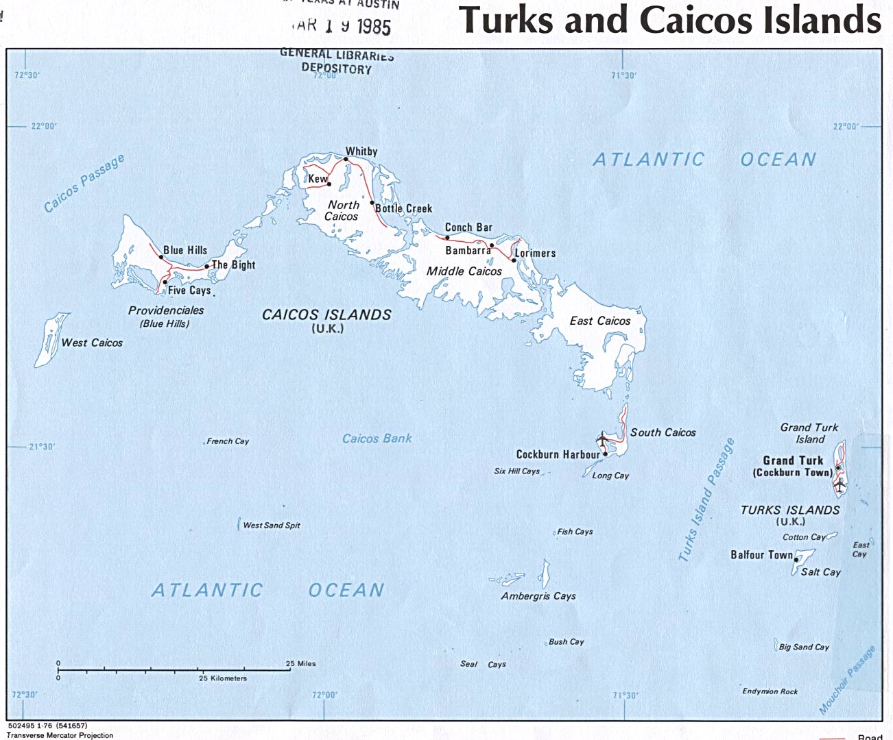
TURKS AND CAICOS INFORMATION
Grand Turk
Grand Turk is a treeless, brush-covered, bean-shaped dot of an isle, just 6.5 miles (10.5km) long and 1.5 miles (2.4km) wide. Grand Turks is dominated in the middle by several salinas, or salt ponds, often odoriferous reminders that `white gold' was the island's most important industry until its collapse in 1962. There are nice beaches on Grand Turk at Cockburn Town, Waterloo and White Sands Beach.
Cockburn Town, the sole settlement on Grand Turk, has been the administrative and political capital of the archipelago for more than 400 years. Today it also claims to be the business and financial center, yet it remains as sleepy a Caribbean capital as they come. There are only two main streets, smothered in sand, trod by an occasional donkey and lined with pastel-painted colonial buildings. Downtown Grand Turk has many Bermuda-style wooden houses erected by the wealthy Bermudian expatriate society that once dominated the salt trade.
The waterfront on Grand Turk has the best sights in Cockburn Town, including historic Turks and Caicos Islands government buildings surrounding a small plaza where a Columbus Monument claims cheekily that the explorer landed here in 1492. Nearby, four large cannons point to sea, where a nearby coral reef is protected within the Columbus Landfall National Park. It's worth nipping into the General Post Office to admire the Turks and Caicos Islands Philatelic Bureau's beautiful stamps, for which the Turks & Caicos are justly famous. The Turks and Caicos Islands National Museum displays eclectic miscellany such as exhumed shell tools, beads, stamps, locks, and greenstone celts. The museum's central exhibit is the remains of the Molasses Reef, the oldest authenticated shipwreck in the Americas.
Salt Cay
Sun-baked Salt Cay, 9 miles (15km) south of Grand Turk, is a mere speck of land, but steeped in character. It's something of a museum of 19th-century industry, with its decrepit windmills, salt sheds and smelly salinas. The modern history of the Turks and Caicos Islands begins in Salt Cay in the mid-1600s, when Bermudian salt traders settled. They created ponds linked to the sea by canals and sluice gates, with windmills controlling water flow. At one time, Salt Cay was the world's largest producer of salt: in its heyday, over 100 vessels a year left the island for the US with their cargo of `white gold'. Today things are less hectic and Salt Cay still awaits its first asphalt - though it has barely a dozen cars. Donkeys, wild cattle and iguanas far outnumber the 125 human inhabitants.
Historic Balfour Town on Salt Cay boasts several old two-story homes with wide verandas and jalousied windows. The most noteworthy attraction in town is the splendidly preserved White House, a stately salt-merchant's manor built in 1835 with ballast stone. Next door is the old wooden Treasury Building, where salt-workers once collected their pay; and, nearby, St John's Anglican Church and the District Commissioner's Office, housing the old jail. If this sounds too modest, the local beaches are superb.
Providenciales
As recently as 1964, Providenciales (usually called Provo) did not have a single wheeled vehicle. Following in the footsteps of Club Med, the island's first large hotel and casino complex opened in 1990 and touched off a development boom. Provo is now the most tourist-oriented and developed of the Turks and Caicos Islands, boasting many resort hotels and an 18-hole golf course. The island has recently become popular with retirees from around the world, kindling a boom of residential development. Given its recent evolution, the atmosphere is more reminiscent of the Florida Keys than Nassau, with little of the character of other Caribbean isles.
The resorts on Providenciales are centered on five mile-long (8km) Grace Bay, with its brilliant white sand and shimmering turquoise waters. Apart from the beaches, Provo's charm lies in its rugged hills and ridges, which are carpeted with prickly pear cactus and scrub. The trump card, however, remains the diving: miles and miles of coral reefs are temptingly close to shore. Provo is also surrounded by uninhabited cays that are easily reached by chartered boat or excursion.
The only town, sprawling, soulless namesake Providenciales, sits in the middle of the island. Most of the island's services are here, including snazzy shopping malls. There are also pockets of makeshift shacks - the homes of Haitians - interspersed among the more upscale residences. Opportunities for sightseeing are slim, though history buffs might check out the ruins of Cheshire Hall, a 1790s plantation house constructed by British loyalists.
The western half of Provo is mostly barren wilderness, home to the island's best natural attraction, Chalk Sound National Park. The park is a three-mile-long (5km) bay a few miles southwest of downtown Providenciales. The color of the water is a uniform turquoise and studded with countless mushroom-like tiny islets. Also on the western part of the island is Northwest Point Marine National Park, which extends to nearby reefs and several saline lakes that attract breeding and migrant waterfowl. You'll have to hike to get there.
South Caicos
The easternmost and smallest Caicos island, South Caicos, 22 miles (35km) west of Grand Turk, is an arid wasteland of scrub and sand-blasted streets roamed by wild horses and donkeys. The big attraction is scuba diving: a reef with a plummeting wall runs the length of the eastern coast. Cockburn Harbour, the only town, is a rough-edged place with a somewhat sullen population and a rakishly appealing down-in-the-dumps shantytown feel. Corrugated-tin-and-driftwood shacks are interspersed amid modern bungalows and handsome, albeit weathered, colonial-era wooden structures left from the salt-trade era. Most historic buildings are at the southeastern end of town, centered on the old Wesleyan Church. The harbor is the perfect spot to launch across the 40-mile-wide (64km) Caicos bank in search of bonefish. Birders should check out the flamingos which inhabit the vast salinas on the northeastern edge of town.
Much of the island is within the Admiral Cockburn Land & Sea Park, north and east of Cockburn Harbour. It encompasses the Sail Rock Hills, a ridge extending along the panhandle and rising to a giddy 178 feet (54m). The hills offer spectacular views east over the Turks Island Passage and west over Belle Sound, a vast turquoise bay opening to the flats of the Caicos Bank. The reserve extends west for about 4 miles (6.5km) , protecting the mangroves, bonefish flats and coral reefs.