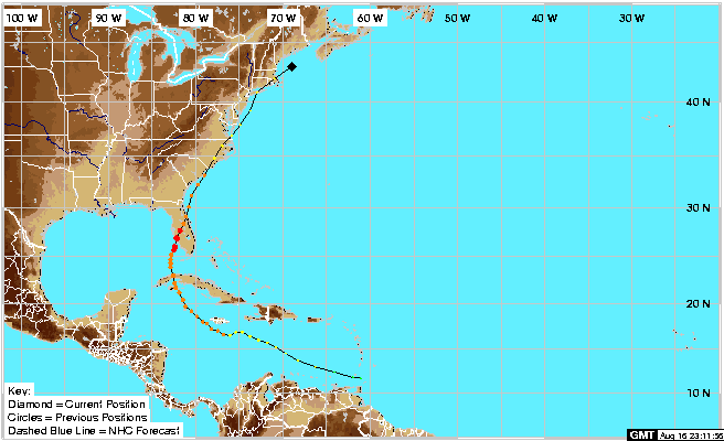
http://www.moreweather.com/tropics/2004 ... HARLEY.gif
Very eerie. Does anyone know what the difference may be??
Eerie similarities here.
Moderator: S2k Moderators
Forum rules

The posts in this forum are NOT official forecasts and should not be used as such. They are just the opinion of the poster and may or may not be backed by sound meteorological data. They are NOT endorsed by any professional institution or STORM2K. For official information, please refer to products from the National Hurricane Center and National Weather Service.

-
latemodel25

- Category 1

- Posts: 454
- Joined: Sat Sep 04, 2004 4:15 am
- Location: parrish fl
- Contact:
-
Stormsfury

- Category 5

- Posts: 10549
- Age: 53
- Joined: Wed Feb 05, 2003 6:27 pm
- Location: Summerville, SC
Charley and Ivan BOTH did a WEST and SOUTHWEST jog around Jamaica, possibly caused by the drag on the northern side of each respective storm due to the high mountains and the bucking of winds off of those ...
However, the BIGGEST difference is the synoptic scale setup ...
First of all, Charley's recurvature to the NORTH and NNE was a no-brainer, induced by an exceptional strong trough in late August which basically guaranteed Charley's capture and turn ...
Ivan has no such unprecedented or even a strong trough in the short term to be hooked around ...
SF
0 likes

CubbyNole
I think the big difference is the intensity/strength of the trough coming down into the gulf. In mid-August there was a remarkable string of record low temperatures in the northern gulf coast area, I believe on Friday, August 13th, the day Charley made landfall, Pensacola had a record low of 63 degrees. 63 degrees anywhere in Florida in Mid-August is a huge anomoly. While there is a trough expected to venture south, I don't believe it will go as for, nor be as strong as the one that came through to shove Charley so sharply east.
But of course that's just my opinion, I could be wrong
But of course that's just my opinion, I could be wrong
0 likes
-
bwstg
Stormsfury wrote:Charley and Ivan BOTH did a WEST and SOUTHWEST jog around Jamaica, possibly caused by the drag on the northern side of each respective storm due to the high mountains and the bucking of winds off of those ...
However, the BIGGEST difference is the synoptic scale setup ...
First of all, Charley's recurvature to the NORTH and NNE was a no-brainer, induced by an exceptional strong trough in late August which basically guaranteed Charley's capture and turn ...
Ivan has no such unprecedented or even a strong trough in the short term to be hooked around ...
SF
StormsFury, you got it. At least you were able to determine the difference unlike the posts above. Thanks...
0 likes
The key is this... Charley passed the isle of youth to the east... Ivan will most likely pass to the west, unless he heads north now.
It is very hard for storms that pass to the west of the isle of youth to hit the peninsula, and generally does not occur.
This storm itself is an anomally though so all bes are of.
It is very hard for storms that pass to the west of the isle of youth to hit the peninsula, and generally does not occur.
This storm itself is an anomally though so all bes are of.
0 likes
-
LAwxrgal

- S2K Supporter

- Posts: 1763
- Joined: Tue Jul 06, 2004 1:05 pm
- Location: Reserve, LA (30 mi west of NOLA)
Eric, don't historical-level hurricanes (such as Ivan) create their own environment to an extent?
0 likes
Andrew 92/Isidore & Lili 02/Bill 03/Katrina & Rita 05/Gustav & Ike 08/Isaac 12 (flooded my house)/Harvey 17/Barry 19/Cristobal 20/Claudette 21/Ida 21 (In the Eye)/Francine 24
Wake me up when November ends
Wake me up when November ends
-
SouthFLTropics

- Category 5
- Posts: 4258
- Age: 50
- Joined: Thu Aug 14, 2003 8:04 am
- Location: Port St. Lucie, Florida
Who is online
Users browsing this forum: No registered users and 159 guests