Personal Disclaimer: All official products are located at http://www.nhc.noaa.gov/ . For warning and evacuation information, please turn to your local NWS office website via a link at http://www.srh.noaa.gov/ or tune in to your local television station.
Graphic Disclaimer: The Graphic provided in this forecast is not official in any way and not endorsed by S2K, NWS, or NOAA.
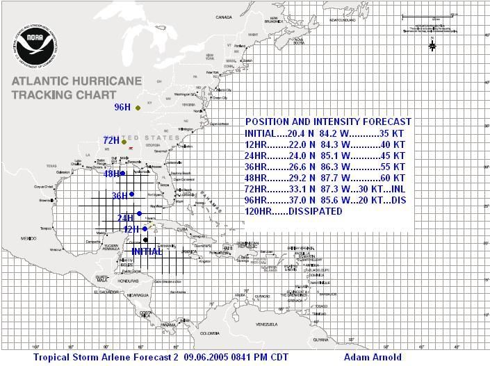
Today has been interesting in the life of newly-formed Tropical Storm Arlene (01L). Arlene has moved north fairly slowly towards the western tip of Cuba and has become better organized throughout the day. It looks like as of right now, it is possible that we may be seeing a reformation of the center under the convection. This needs to be watched throughout the night and into tomorrow. If this does indeed occur, strengthening will be a bit quicker as shear does lessen. One concern that several people have noted is the dry air to the west hampering the system's ability to strengthen. While this is possible, right now I see the dry air having minimal effects as the trough that is causing it weakens and retreats away from Arlene. This will also reduce the shear over Arlene, furthermore allowing her to strengthen.
My forecast is fairly straightforward with one minor exception. I have adjusted slightly just in case the center does reform to under the convection, so the projected path on here is actually a midway compromise of the location of the current center, vs. the possible relocation of the center under the thunderstorm complex (with the exception of the initial plot). Therefore, my forecast has in fact shifted a tad east of the previous one. I also increase the strength slightly just before landfall to 60 KT. While I think it is a 50% chance between 55 and 60 KT, I decided to be optimistic with the wind speed forecast because of higher strengthening probabilities if the storm relocates its center under the deep convection. Right now, I give the storm a 30% chance of becoming a minimal category 1 hurricane before landfall. There is an outside chance that it becomes anything but that, but I expect Arlene to be only a strong tropical storm at landfall for now.
If you have any further questions, please feel free to ask!
Graphic for 01L Arlene, 09.06.2005: