2/4-6 Ohio Valley/Southern Ontario Snow Threat

Winter Weather Discussion

Moderator: S2k Moderators

Forum rules

The posts in this forum are NOT official forecast and should not be used as such. They are just the opinion of the poster and may or may not be backed by sound meteorological data. They are NOT endorsed by any professional institution or
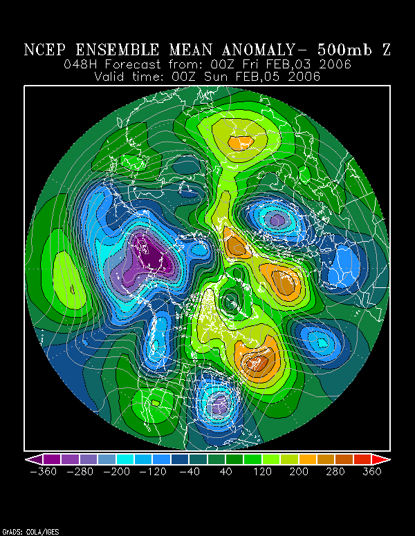
 STORM2K.

Help Support Storm2K
Message
Author
donsutherland1
S2K Analyst
S2K Analyst
Posts: 2718
Joined: Mon Sep 15, 2003 8:49 pm
Location: New York

2/4-6 Ohio Valley/Southern Ontario Snow Threat

#1 Postby donsutherland1 » Fri Feb 03, 2006 2:09 pm

There remain some fairly significant disagreements between the 12z NAM and GFS in terms of qpf and especially soundings concerning the transition from rain to snow. The NCEP ensemble mean 500 mb height anomalies suggest a somewhat more amplified situation than was noted last night.

Latest for 2/5 0z:
Image

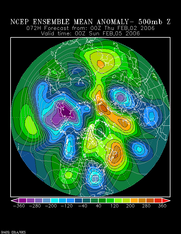
Previous for 2/5 0z:
Image

Overall, across the modeling there is some good agreement on a number of issues:

∙ Rain will likely transition to snow across the Ohio Valley and southern Ontario.
∙ A small difference in the track could make a large difference in terms of accumulations.
∙ Lake effect snow could enhance accumulations in the Cleveland and Buffalo areas.

Given the uncertainties still involved, a compromise of the 2/3 0z ECMWF and 2/3 12z GFS and NAM appears reasonable to me. Estimates in central Ohio e.g., Columbus, are on the conservative side for now.

Initial Estimates (2/4-6):
Buffalo: 2"-5"
Cleveland: 3"-7"
Columbus: 1"-3"
London: 3"-6"
Pittsburgh: 1"-3"
Toronto: 3"-6"
0 likes   

donsutherland1
S2K Analyst
S2K Analyst
Posts: 2718
Joined: Mon Sep 15, 2003 8:49 pm
Location: New York

Re: 2/4-6 Ohio Valley/Southern Ontario Snow Threat

#2 Postby donsutherland1 » Sat Feb 04, 2006 12:27 am

Through the day, the models have trended somewhat more to the west. As a result, snowfall prospects at Toronto have diminished somewhat. Nonetheless, I'm still not inclined to make drastic reductions in snowfall there. Estimates for the other locations still appear to be in good shape after reviewing the soundings for the 2/4 0z NAM and GFS.

Estimates (2/4-6):
Buffalo: 2"-5"
Cleveland: 3"-7"
Columbus: 1"-3"
Detroit: 4"-8"
Pittsburgh: 1"-3"
Toronto: 2"-4"
0 likes   

donsutherland1
S2K Analyst
S2K Analyst
Posts: 2718
Joined: Mon Sep 15, 2003 8:49 pm
Location: New York

Re: 2/4-6 Ohio Valley/Southern Ontario Snow Threat

#3 Postby donsutherland1 » Sat Feb 04, 2006 12:04 pm

Per a combination of the radar trends, current soundings, and modeled soundings/qpf for tomorrow into Monday, I have made some slight adjustments in my estimates. I am concerned that Buffalo could get into at least some lake effect snow, so I've bumped up totals there by 1"-2".

Final Estimates (2/4-6):
Buffalo: 3"-7"
Cleveland: 3"-7"
Columbus: 1"-3"
Detroit: 4"-8"
Pittsburgh: 2"-4"
Toronto: 2"-5"
0 likes   

User avatar
ohiostorm
Category 5
Category 5
Posts: 1582
Age: 40
Joined: Sat Oct 12, 2002 2:51 pm
Location: Orlando, FL
Contact:

#4 Postby ohiostorm » Sat Feb 04, 2006 1:25 pm

PIT NWS has us now getting 2 to 5" by Sunday. Seems like you are almost dead on!
0 likes   

conestogo_flood
Category 5
Category 5
Posts: 1268
Joined: Wed Sep 28, 2005 5:49 pm

#5 Postby conestogo_flood » Sat Feb 04, 2006 5:20 pm

Last night the local forecast had 45-55cm of snow for the next 24 hours. About 3 inches has fallen from a swatch of 1pm-430pm. Nothing really at the moment, just some rain. I am 100 kms southwest of Toronto in the Kitchener/Waterloo region.

The Weather Network said up to 30cm tonight for southern Ontario.

SEVERE WEATHER BULLETIN
ISSUED BY ENVIRONMENT CANADA
AT 3:53 PM EST SATURDAY 4 FEBRUARY 2006.
---------------------------------------------------------------------
WATCHES/WARNINGS IN EFFECT FOR SOUTHERN ONTARIO...

WIND WARNING FOR:
=NEW= SIMCOE - DELHI - NORFOLK
=NEW= DUNNVILLE - CALEDONIA - HALDIMAND
=NEW= NIAGARA FALLS - WELLAND - SOUTHERN NIAGARA REGION
=NEW= PICTON - SANDBANKS PARK.

STRONG WINDS EXPECTED ON SUNDAY..

THIS IS A WARNING THAT DAMAGING WINDS ARE IMMINENT OR
OCCURRING IN THESE REGIONS. MONITOR WEATHER
CONDITIONS..LISTEN FOR UPDATED STATEMENTS.

WINTER STORM WARNING FOR:
WINDSOR - ESSEX - CHATHAM-KENT
SARNIA - LAMBTON
ELGIN
LONDON - MIDDLESEX
WOODSTOCK - TILLSONBURG - OXFORD COUNTY
CALEDON
NEWMARKET - GEORGINA - NORTHERN YORK REGION
UXBRIDGE - BEAVERTON - NORTHERN DURHAM REGION
HURON - PERTH
WATERLOO - WELLINGTON
DUFFERIN - INNISFIL
GREY - BRUCE
BARRIE - ORILLIA - MIDLAND
LINDSAY - SOUTHERN KAWARTHA LAKES
FENELON FALLS - BALSAM LAKE PARK - NORTHERN KAWARTHA LAKES
APSLEY - WOODVIEW - NORTHERN PETERBOROUGH COUNTY
BANCROFT - BON ECHO PARK
PARRY SOUND - MUSKOKA - HUNTSVILLE
HALIBURTON
RENFREW - PEMBROKE - BARRY'S BAY
ALGONQUIN
BURK'S FALLS - BAYFIELD INLET.

A WINTER STORM AFFECTING SOUTHERN ONTARIO TONIGHT AND SUNDAY.

THIS IS A WARNING THAT DANGEROUS WINTER WEATHER CONDITIONS ARE
IMMINENT OR OCCURRING IN THESE REGIONS. MONITOR WEATHER
CONDITIONS..LISTEN FOR UPDATED STATEMENTS.

RAINFALL WARNING FOR:
CITY OF TORONTO
BRANTFORD - COUNTY OF BRANT
ST. CATHARINES - GRIMSBY - NORTHERN NIAGARA REGION
SIMCOE - DELHI - NORFOLK
DUNNVILLE - CALEDONIA - HALDIMAND
NIAGARA FALLS - WELLAND - SOUTHERN NIAGARA REGION
CITY OF HAMILTON
BURLINGTON - OAKVILLE
HALTON HILLS - MILTON
MISSISSAUGA - BRAMPTON
VAUGHAN - RICHMOND HILL - MARKHAM
PICKERING - OSHAWA - SOUTHERN DURHAM REGION.

A WINTER STORM WILL DELIVER SNOW FOLLOWED BY SIGNIFICANT RAIN
TO THE ABOVE REGIONS.

---------------------------------------------------------------------
==DISCUSSION==
A DISTURBANCE OVER EASTERN OHIO IS RAPIDLY DEEPENING INTO AN INTENSE
WINTER STORM. THE CENTRE OF THE STORM IS FORECAST TO REACH LAKE ERIE
BY THIS EVENING THEN PETAWAWA BY LATE SUNDAY.

SNOW..HEAVY AT TIMES..HAS DEVELOPED ACROSS MUCH OF SOUTHWESTERN
ONTARIO NORTH INTO SKI COUNTRY THIS AFTERNOON. RAIN IS OCCURRING
OVER THE NIAGARA PENINSULA. WET SNOW IS OCCURRING IN TORONTO WITH
THE MERCURY HOVERING JUST ABOVE THE FREEZING MARK. A FEW CENTIMETRES
OF SNOW ARE EXPECTED THIS EVENING IN AND AROUND THE GTA WHILE MUCH
HEAVIER SNOW AMOUNTS ARE EXPECTED TO THE NORTHWEST OF TORONTO SUCH
AS THE HIGHER TERRAIN OF THE DUNDALK HIGHLANDS AND ABOVE THE NIAGARA
ESCARPMENT. SIGNIFICANT RAINFALL AMOUNTS UP TO 25 MM ARE LIKELY IN
PARTS OF THE GOLDEN HORSESHOE WHILE LESSER AMOUNTS ARE FORECAST FOR
EASTERN ONTARIO WHERE THE RAINFALL WARNING HAS BEEN ENDED.

LATER THIS EVENING MILDER AIR WILL PUSH INTO THE GOLDEN HORSESHOE
CHANGING THE SNOW TO RAIN WHILE SNOW WILL CONTINUE IN THE WINTER
STORM WARNING AREAS FROM SOUTHWESTERN ONTARIO THROUGH SKI COUNTRY.
STRONG NORTHEAST WINDS OF 40 GUSTING TO 60 KM/H HAVE ALSO DEVELOPED
CREATING EXTENSIVE LOW VISIBILITY LESS THAN 500 METRES IN FALLING..
DRIFTING AND BLOWING SNOW. SNOWFALL AMOUNTS OF 20 TO 30 CM MAY BE
EXPECTED IN THE HEAVY SNOW SWATH BY MORNING.

ON SUNDAY THE BACK END OF THE STORM WILL DELIVER A NASTY WINTERY
PUNCH TO ALL OF SOUTHERN ONTARIO. STRONG WEST TO NORTHWEST WINDS TO
60 KM/H OR MORE WILL BE ACCOMPANIED BY THE SNOW WITH FURTHER
APPRECIABLE ACCUMULATIONS OF 5 TO LOCALLY 10 CM WITH BLOWING SNOW
AS WELL. THE STRONGEST WINDS WILL BE ALONG THE NORTH SHORE OF LAKES
ONTARIO AND ERIE WHERE SOUTHWEST WINDS OF 60 GUSTING TO 90 KM/H WILL
DEVELOP. TOTAL SNOWFALL AMOUNTS MAY VERY WELL REACH IN EXCESS OF 30
CENTIMETRES BY SUNDAY NIGHT IN THE HARDEST HIT AREAS.

THIS IS A SERIOUS STORM WITH A SIGNIFICANT IMPACT OVER A LARGE
PORTION OF THE PROVINCE. ENVIRONMENT CANADA WILL CONTINUE TO MONITOR
ITS DEVELOPMENT. PLEASE REFER TO THE LATEST PUBLIC FORECASTS FOR
FURTHER DETAILS.
0 likes   

User avatar
ohiostorm
Category 5
Category 5
Posts: 1582
Age: 40
Joined: Sat Oct 12, 2002 2:51 pm
Location: Orlando, FL
Contact:

#6 Postby ohiostorm » Sun Feb 05, 2006 1:57 am

I would say we will end up with around an inch here by tomorrow night. Nothing real impressive on radar.
0 likes   

Miss Mary

#7 Postby Miss Mary » Sun Feb 05, 2006 11:44 am

Same here, wet snow that accumulated on trees, grass but pavement remained wet yesterday. Overnight, blowing and drifting covered roadways but salt took care of it promptly (trucks at the ready).

Pretty to look at but all total, probably an inch at our house too.

Mary
0 likes   

User avatar
Tri-State_1925
Category 1
Category 1
Posts: 341
Joined: Fri Aug 13, 2004 11:16 am
Location: Worcester Hills, MA

#8 Postby Tri-State_1925 » Sun Feb 05, 2006 2:34 pm

Wow, looks like that was a bust for a lot of non-lake effect areas...
0 likes   

donsutherland1
S2K Analyst
S2K Analyst
Posts: 2718
Joined: Mon Sep 15, 2003 8:49 pm
Location: New York

Re: 2/4-6 Ohio Valley/Southern Ontario Snow Threat

#9 Postby donsutherland1 » Tue Feb 07, 2006 9:09 am

Verification:
February 4-6, 2006 Snowfall Amounts

With the exception of Toronto, my amounts proved too high. The worst busts occurred in Buffalo and Detroit, as significant snows occurred just to Detroit's north and lake effect snows set up just to the south of Buffalo. Overall, less snow than I had expected fell as it took a little longer for the storm to deepen.

From 2/3/2006 12:30 pm:
Buffalo: 2"-5"; Actual: 0.5"; Error: 1.5"
Cleveland: 3"-7"; Actual: 2.5"; Error: 0.5"
Columbus: 1"-3"; Actual: 0.6"; Error: 0.4"
Pittsburgh: 1"-3"; Actual: 1.6"; Within range
Toronto: 3"-6"; Actual: 2.6"; Error: 0.4"

From 2/4/2006 12:30 am:
Buffalo: 2"-5"; Actual: 0.5"; Error: 1.5"
Cleveland: 3"-7"; Actual: 2.5"; Error: 0.5"
Columbus: 1"-3"; Actual: 0.6"; Error: 0.4"
Detroit: 4"-8"; Actual: 1.9"; Error: 2.1"
Pittsburgh: 2"-4"; Actual: 1.6"; Error: 0.4"
Toronto: 2"-4"; Actual: 2.6"; Within range

From 2/4/2006 12:00 pm:
Buffalo: 3"-7"; Actual: 0.5"; Error: 2.5"
Cleveland: 3"-7"; Actual: 2.5"; Error: 0.5"
Columbus: 1"-3"; Actual: 0.6"; Error: 0.4"
Detroit: 4"-8"; Actual: 1.9"; Error: 2.1"
Pittsburgh: 2"-4"; Actual: 1.6"; Error: 0.4"
Toronto: 2"-5"; Actual: 2.6"; Within range
0 likes   

User avatar
WaitingForSiren
Category 1
Category 1
Posts: 383
Joined: Sun Jan 08, 2006 12:58 pm
Location: Minneapolis,Minnesota
Contact:

#10 Postby WaitingForSiren » Tue Feb 07, 2006 3:26 pm

I dont see how a forecast of 4-8 inches could have an error of only 2.1 when only 1.9 inches fell. To me, that's like like a 4 inch error.

I forecasted 1-3 inches for Detroit, so it looks like my forecast went pretty good.
0 likes   

Tyler

#11 Postby Tyler » Tue Feb 07, 2006 3:27 pm

WaitingForSiren wrote:I dont see how a forecast of 4-8 inches could have an error of only 2.1 when only 1.9 inches fell. To me, that's like like a 4 inch error.

I forecasted 1-3 inches for Detroit, so it looks like my forecast went pretty good.


How is it a 4 inch error? He had a range of 4-8, 1.9 fell, and thats 2.1 in away from his margin...
0 likes   


Return to “Winter Weather”

Who is online

Users browsing this forum: No registered users and 14 guests