
http://www.nhc.noaa.gov/pns1_2006.shtml?
The NHC will discontinue some products and add other ones.Read what will be discontinued and which will be added to the forecasts during the 2006 hurricane season.
NHC=Changes in Tropical Cyclone Probabilistic Products
Moderator: S2k Moderators
Forum rules

The posts in this forum are NOT official forecasts and should not be used as such. They are just the opinion of the poster and may or may not be backed by sound meteorological data. They are NOT endorsed by any professional institution or STORM2K. For official information, please refer to products from the National Hurricane Center and National Weather Service.

I was hopeful I'd see a new product for predicting/forecasting surge potential for a given coastline. While it's certainly necessary to be aware of the wind and track, as these products provide, it is much more necessary - I believe - to forewarn the public of the expected surge. In other words, the surge potential should receive as much, if not more than, attention as the wind potential.
Surely, had the MS coast received only wind from Katrina, the damage, death count, and on-going recovery would have been SIGNIFICANTLY less than what it turned out to be. And N.O. may or may not have had the same result - hard to say because their situation is so different than ours with the levees and being below sea level...
Luis, do you know of any newer products coming from the NHC that might bring the surge issues more pointedly to the public's knowledge??
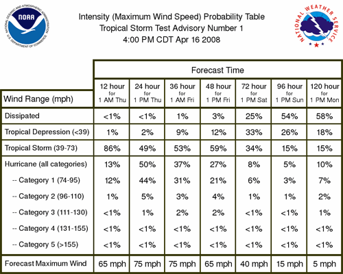
I wonder, also, why CAT 4 & 5 were not separated into their own column and percentages in this graphic:
Surely, had the MS coast received only wind from Katrina, the damage, death count, and on-going recovery would have been SIGNIFICANTLY less than what it turned out to be. And N.O. may or may not have had the same result - hard to say because their situation is so different than ours with the levees and being below sea level...
Luis, do you know of any newer products coming from the NHC that might bring the surge issues more pointedly to the public's knowledge??
I wonder, also, why CAT 4 & 5 were not separated into their own column and percentages in this graphic:
0 likes
-
Margie
There is already such a product, but it is not NHC's responsibility to use it...it is the Hurricane Evac Study (HES) maps (USACE) and tool (CSC), which already shows surge potential down to a street address. These studies have been done for a number of basins in the GOM (go to the USACE site to learn more).
It available for everyone with web access to use, if they want to know the flooding potential for their home address or surrounding real estate. The maps can be downloaded and printed by local govt.
And, you don't even need to check it with every hurricane that comes along -- you can check it just once to see the flood zone you are in (although you might at that time also want to check for the lowest flood zone that crosses any place you would normally use as an evacuation route; for instance, if you must cross a road that floods where it goes over a stream fed by a bayou, go by that lower flood zone, not the one your home is located in).
Or you can print it out and refer to it every time a hurricane threatens.
Given the nature of surge along shallow coastlines such as the northern GOM and FL's east coast, and the nature of hurricanes to weaken as they approach the northern GOM coast, the best way for an individual on the northern GOM to use this product is to go by the Cat rating the hurricane has the day before hitting the coast, and use that rating as the surge potential.
NHC does not use SSHS for surge. The surge warnings given by NHC for Katrina were accurate.
In Jackson County, the Sheriff's Dept was told on Sunday to expect a surge between 15 and 20 feet. That is very close to the actual surge received in that county: at the far east, Pascagoula received between 16-18 ft of surge, 15 ft was experienced to the east of Pascagoula. At the far western edge of the county, only small portions of coastal areas facing SE GOM or Biloxi Bay received a little higher...21-22 feet. But if you add on the 1-2 foot high tide on top of the surge, then the numbers do fall into line exactly. But even given the warning, apparently the HES maps weren't used to gain an understanding of what areas of the county would be underwater (as it turned out, a considerable amount).
Also, remember that most people did not have an accurate idea of their elevation. There are numerous newspaper accounts after the storm where this can be observed, in many cases leading to the idea that the surge was some extremely large number of feet. My own mother was mistaken about the height of her home (her source?...her insurance agent). Many believed their elevation to be much higher than it actually was. Recall the Jim Cantore faux pas...The Weather Channel believed what they were told by someone local, that the Armed Forces Retirement Home was at 27 ft elevation, when 30 seconds online using Topozone or another web site could have easily confirmed it was at 15 ft elevation. So they sent a TV crew to a place that was 10 feet below a location they believed would receive a 25-ft surge (here, surge used in the context of storm tide), and they had to go to the 2nd or 3rd floor because the building received 10 feet of water. To compound the error, they then mistakenly broadcast that there was 37 feet of surge at that location .
To give a more recent example, yesterday WLOX published a story, backed up by their head meteorologist, that the Beau Rivage blocked the surge from businesses and residences north of it, and kept them high and dry. The story ends with a quote:
"When a hurricane comes, with that being there, it's definitely going to save us," said Randy Barras.
Now I watched the video, and Mr. Barras seems like an awfully nice fellow. As we can use more nice people in the world, I hope he doesn't get swept or blown away by the next hurricane, thinking that a tall building will protect him, when it was simply that his business was at a higher elevation than the height of the storm tide, and was not "protected" at all (in fact, buildings directly in front of the Beau, that were in the surge area and were reduced to a pile of rubble, might have even been subjected to a higher current from Bernoulli effect caused by the surge incoming between the Beau and the next building over to the east).
Surge is the most serious threat from a hurricane. The surge numbers were out there and if they did not receive enough attention it is due to local agencies not getting the word out, or emphasizing it enough.
The great advantage of using the HES maps (which are derived from worst case scenarios using many SLOSH runs) is that you don't have to know your elevation; all you have to do is go look up your street address and see what flood zone you are in: Cat 1 through Cat 5. These maps proved to be extraordinarily accurate in hindcasts for Katrina (even more accurate on an address-by-address level than the actual Katrina SLOSH run).
For some reason, the HES maps were not displayed on local TV, were not used by emergency management, even though they are not new, and they do show the potential for flooding (which, along the MS Gulf Coast, is greatest in Hancock and Jackson Counties...most of Harrison is on higher ground). Clearly, not even in use by TWC.
Last edited by Margie on Wed Feb 08, 2006 11:53 pm, edited 3 times in total.
0 likes
-
JonathanBelles
- Professional-Met

- Posts: 11430
- Age: 35
- Joined: Sat Dec 24, 2005 9:00 pm
- Location: School: Florida State University (Tallahassee, FL) Home: St. Petersburg, Florida
- Contact:
-
Extremeweatherguy

- Category 5

- Posts: 11095
- Joined: Mon Oct 10, 2005 8:13 pm
- Location: Florida

Margie wrote:There is already such a product, but it is not NHC's responsibility to use it...
If the maps already exist in reliable format - that's great. The problem remains in that the NHC concentrates so highly on the wind aspects that the public tends to concentrate on that to the same degree. Consequently, many coastal residents do not realize or recognize the surge potential because it does not (or at least did not) get reported with the same emphasis as the wind potential.
My point with the NHC products is that, because they are considered by the general public to be the sole and central experts on tropical systems, THEY should provide models, guidance, and graphics on surge to the SAME degree that they provide them on the wind.
Without a doubt, John Q. Public has no idea that the Hurricane Evac Study (HES) maps exist and that USACE, CSC, SSHS, or SLOSH have any connection whatsoever to a tropical event. From a layman's perspecitve, we look to the NHC to provide us with forecasts, guidance, and graphics on the potential damage of a landfalling hurricane. Unfortunately, it seems to me that the NHC is interested mainly in the less significant aspects of the wind...
0 likes
-
Margie
Ixolib wrote:If the maps already exist in reliable format - that's great.
No...I just made it up. What do you think?
Ixolib wrote:The problem remains in that the NHC concentrates so highly on the wind aspects that the public tends to concentrate on that to the same degree. My point with the NHC products is that, because they are considered by the general public to be the sole and central experts on tropical systems, THEY should provide models, guidance, and graphics on surge to the SAME degree that they provide them on the wind.
NHC always provides warnings for wind, surge, rain, etc as needed in the public advisories, which are a product with written guidelines and are required to contain specific information in a standard format. Let's just leave it at...you're very confused about what the NHC provides.
Ixolib wrote:Without a doubt, John Q. Public has no idea that the Hurricane Evac Study (HES) maps exist and that USACE, CSC, SSHS, or SLOSH have any connection whatsoever to a tropical event.
I think it's pretty safe to say the public has an idea that the SSHS has a connection to tropical cyclones. If you say, "Cat 5" to someone, I don't think they're going to ask where the first four cats are. Which begs the question...do you have any idea what any of those abbreviations are? Do you ever consider using, say, Google, to expand your horizons?
Since you're saying you are so concerned with finding information on surge, now that you are aware that there is a map showing worst case surge zones, do you have any burning desire to go find it and look up your address to see what zone you are in?
Ixolib wrote:From a layman's perspecitve, we look to the NHC to provide us with forecasts, guidance, and graphics on the potential damage of a landfalling hurricane..
You should be looking at your local weather information, not relying on NHC products, which do not contain local forecasts. I think if your area is in the cone, your local weather forecasts will manage to let you know, and if you should be evacuating, I'm sure you'll hear about it from local news sources.
0 likes
Margie wrote:Ixolib wrote:If the maps already exist in reliable format - that's great.
No...I just made it up. What do you think?Ixolib wrote:The problem remains in that the NHC concentrates so highly on the wind aspects that the public tends to concentrate on that to the same degree. My point with the NHC products is that, because they are considered by the general public to be the sole and central experts on tropical systems, THEY should provide models, guidance, and graphics on surge to the SAME degree that they provide them on the wind.
NHC always provides warnings for wind, surge, rain, etc as needed in the public advisories, which are a product with written guidelines and are required to contain specific information in a standard format. Let's just leave it at...you're very confused about what the NHC provides.Ixolib wrote:Without a doubt, John Q. Public has no idea that the Hurricane Evac Study (HES) maps exist and that USACE, CSC, SSHS, or SLOSH have any connection whatsoever to a tropical event.
I think it's pretty safe to say the public has an idea that the SSHS has a connection to tropical cyclones. If you say, "Cat 5" to someone, I don't think they're going to ask where the first four cats are. Which begs the question...do you have any idea what any of those abbreviations are? Do you ever consider using, say, Google, to expand your horizons?
Since you're saying you are so concerned with finding information on surge, now that you are aware that there is a map showing worst case surge zones, do you have any burning desire to go find it and look up your address to see what zone you are in?Ixolib wrote:From a layman's perspecitve, we look to the NHC to provide us with forecasts, guidance, and graphics on the potential damage of a landfalling hurricane..
You should be looking at your local weather information, not relying on NHC products, which do not contain local forecasts. I think if your area is in the cone, your local weather forecasts will manage to let you know, and if you should be evacuating, I'm sure you'll hear about it from local news sources.
Margie why the temperment?I thought the point was valid in respect to the said general publc persay.The other 99% of the public does not seek the internet as there source on hurricane warnings.I thought that this thread might stay away from any emotional debate please.
0 likes
-
vbhoutex

- Storm2k Executive

- Posts: 29140
- Age: 74
- Joined: Wed Oct 09, 2002 11:31 pm
- Location: Cypress, TX
- Contact:
Javlin wrote:Margie wrote:Ixolib wrote:If the maps already exist in reliable format - that's great.
No...I just made it up. What do you think?Ixolib wrote:The problem remains in that the NHC concentrates so highly on the wind aspects that the public tends to concentrate on that to the same degree. My point with the NHC products is that, because they are considered by the general public to be the sole and central experts on tropical systems, THEY should provide models, guidance, and graphics on surge to the SAME degree that they provide them on the wind.
NHC always provides warnings for wind, surge, rain, etc as needed in the public advisories, which are a product with written guidelines and are required to contain specific information in a standard format. Let's just leave it at...you're very confused about what the NHC provides.Ixolib wrote:Without a doubt, John Q. Public has no idea that the Hurricane Evac Study (HES) maps exist and that USACE, CSC, SSHS, or SLOSH have any connection whatsoever to a tropical event.
I think it's pretty safe to say the public has an idea that the SSHS has a connection to tropical cyclones. If you say, "Cat 5" to someone, I don't think they're going to ask where the first four cats are. Which begs the question...do you have any idea what any of those abbreviations are? Do you ever consider using, say, Google, to expand your horizons?
Since you're saying you are so concerned with finding information on surge, now that you are aware that there is a map showing worst case surge zones, do you have any burning desire to go find it and look up your address to see what zone you are in?Ixolib wrote:From a layman's perspecitve, we look to the NHC to provide us with forecasts, guidance, and graphics on the potential damage of a landfalling hurricane..
You should be looking at your local weather information, not relying on NHC products, which do not contain local forecasts. I think if your area is in the cone, your local weather forecasts will manage to let you know, and if you should be evacuating, I'm sure you'll hear about it from local news sources.
Margie why the temperment?I thought the point was valid in respect to the said general publc persay.The other 99% of the public does not seek the internet as there source on hurricane warnings.I thought that this thread might stay away from any emotional debate please.
This thread better stay away from an emotional perspective. That is coming from me as a staff member. Some very useful information is being provided here(thanks Margie) and it needs to stay that way. Fair Warning!!!
I must agree with Javlin on this. The general public is woefully unaware of Hurricanes and what they can do(yes even after Katrina)and even more woefully unaware of the different products available, especially on the internet, and especially about the weather in general, much less about tropical cyclones. I would imagine if I walked out the door of my office and found 100 random people to ask about the different models etc. available for forecasting weather, much less Hurricane surge, that maybe 1 out of those 100 would understand what I was asking if I asked what model was best to use for predicting a hurricane.
0 likes
Javlin wrote:Margie why the temperment?I thought the point was valid in respect to the said general publc persay.The other 99% of the public does not seek the internet as there source on hurricane warnings.I thought that this thread might stay away from any emotional debate please.
Thanks, Javlin... In fact, I would imagine that your 99% statement is quite valid, say, from Reynoir Street eastward to The Point, which encompasses quite a lot of area and quite a lot of people. However, those folks DO have T.V.s and they DO understand and recognize that the NHC is the authority and their primary source of information.
Therefore, and back to my original point, had they heard or seen a surge graphic that was reported with the "SAME" emphasis - and from the recognized authority - as they heard and saw the wind graphics, I believe the end result may have been different in that part of town, and in other areas of a similar nature.
As for the poster who choose to flame my point, it is becoming increasingly obvious that her (or his??) chosen method of participating in this board is contrary to type of input provided by the vast majority of its members. Consequently, I will continue to take those types of replies with the appropriate amount of censure necessary to maintain the integrity of this forum.
All things contrary will correct themselves in due time. Board history has proven that...
0 likes
-
terstorm1012

- S2K Supporter

- Posts: 1314
- Age: 44
- Joined: Fri Sep 10, 2004 5:36 pm
- Location: Millersburg, PA

Margie wrote:Ixolib wrote:If the maps already exist in reliable format - that's great.
No...I just made it up. What do you think?Ixolib wrote:The problem remains in that the NHC concentrates so highly on the wind aspects that the public tends to concentrate on that to the same degree. My point with the NHC products is that, because they are considered by the general public to be the sole and central experts on tropical systems, THEY should provide models, guidance, and graphics on surge to the SAME degree that they provide them on the wind.
NHC always provides warnings for wind, surge, rain, etc as needed in the public advisories, which are a product with written guidelines and are required to contain specific information in a standard format. Let's just leave it at...you're very confused about what the NHC provides.Ixolib wrote:Without a doubt, John Q. Public has no idea that the Hurricane Evac Study (HES) maps exist and that USACE, CSC, SSHS, or SLOSH have any connection whatsoever to a tropical event.
I think it's pretty safe to say the public has an idea that the SSHS has a connection to tropical cyclones. If you say, "Cat 5" to someone, I don't think they're going to ask where the first four cats are. Which begs the question...do you have any idea what any of those abbreviations are? Do you ever consider using, say, Google, to expand your horizons?
Since you're saying you are so concerned with finding information on surge, now that you are aware that there is a map showing worst case surge zones, do you have any burning desire to go find it and look up your address to see what zone you are in?Ixolib wrote:From a layman's perspecitve, we look to the NHC to provide us with forecasts, guidance, and graphics on the potential damage of a landfalling hurricane..
You should be looking at your local weather information, not relying on NHC products, which do not contain local forecasts. I think if your area is in the cone, your local weather forecasts will manage to let you know, and if you should be evacuating, I'm sure you'll hear about it from local news sources.
The sarcasm isn't necessary.
Most of us here had or have family/freinds that lost everything due to the surge from Katrina.
No map would have made a difference here. If category 5 Camille didn't
flood some areas, then certainly no other storm could - that's what most thought.
0 likes
Who is online
Users browsing this forum: cycloneye and 73 guests