EPAC to an Early Start Maybe with Possible Invest - 8N 125W?

This is the general tropical discussion area. Anyone can take their shot at predicting a storms path.

Moderator: S2k Moderators

Forum rules

The posts in this forum are NOT official forecasts and should not be used as such. They are just the opinion of the poster and may or may not be backed by sound meteorological data. They are NOT endorsed by any professional institution or STORM2K. For official information, please refer to products from the National Hurricane Center and National Weather Service.

Help Support Storm2K
Message
Author
User avatar
gatorcane
S2K Supporter
S2K Supporter
Posts: 23694
Age: 47
Joined: Sun Mar 13, 2005 3:54 pm
Location: Boca Raton, FL

EPAC to an Early Start Maybe with Possible Invest - 8N 125W?

#1 Postby gatorcane » Mon Apr 10, 2006 3:02 pm

Looks like there is some nice sustained convection at 8N 125W. If you loop it, it seems to be getting better organized. There are some other blobs east of this blob also. Keep in mind the EPAC season starts May 15th, two weeks earlier than the Atlantic Hurricane season.

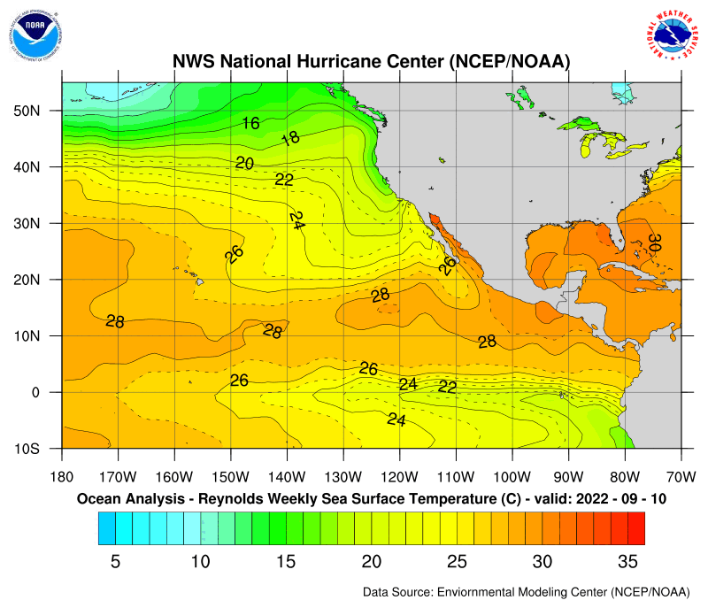
Wind shear is around 20K also which isn't that bad. SSTs are also favorable running around the SSTs in the Caribbean at around 27C

Loop:http://www.ssd.noaa.gov/PS/TROP/DATA/RT/cpac-ir4-loop.html

Image

Image

Image
Last edited by gatorcane on Mon Apr 10, 2006 3:20 pm, edited 4 times in total.
0 likes   

MiamiensisWx

#2 Postby MiamiensisWx » Mon Apr 10, 2006 3:12 pm

Maybe... let's see, though.
0 likes   

User avatar
gatorcane
S2K Supporter
S2K Supporter
Posts: 23694
Age: 47
Joined: Sun Mar 13, 2005 3:54 pm
Location: Boca Raton, FL

#3 Postby gatorcane » Mon Apr 10, 2006 3:13 pm

it would be a little over 4 weeks since the start of the EPAC season...not that far off.

You really need to loop the image to see that it does seem like the best blob we have seen in both the Atlantic and Pacific Basins in many months.
0 likes   

MiamiensisWx

#4 Postby MiamiensisWx » Mon Apr 10, 2006 3:19 pm

It looks quite tropical; that I agree on. It may have a chance at an early-season storm (the east-central Pacific blob). It actually has a spin to it; may have some possibility for slight development...

http://www.ssd.noaa.gov/PS/TROP/DATA/RT/cpac-wv-loop.html

Looks like it may have a developing LLC!
0 likes   

User avatar
gatorcane
S2K Supporter
S2K Supporter
Posts: 23694
Age: 47
Joined: Sun Mar 13, 2005 3:54 pm
Location: Boca Raton, FL

#5 Postby gatorcane » Mon Apr 10, 2006 3:22 pm

Does anybody have some info on the the earliest storm that formed in the EPAC, e.g., when and how strong it was?
0 likes   

MiamiensisWx

#6 Postby MiamiensisWx » Mon Apr 10, 2006 3:23 pm

Don't you think it has an impressive spin with it? Outflow may be developing...

http://www.ssd.noaa.gov/PS/TROP/DATA/RT/cpac-wv-loop.html
0 likes   

User avatar
HURAKAN
Professional-Met
Professional-Met
Posts: 46086
Age: 38
Joined: Thu May 20, 2004 4:34 pm
Location: Key West, FL
Contact:

#7 Postby HURAKAN » Mon Apr 10, 2006 3:25 pm

Since records began in the EPAC, there has never been a tropical cyclone forming in April.
0 likes   

User avatar
gatorcane
S2K Supporter
S2K Supporter
Posts: 23694
Age: 47
Joined: Sun Mar 13, 2005 3:54 pm
Location: Boca Raton, FL

#8 Postby gatorcane » Mon Apr 10, 2006 3:25 pm

I think it looks better than some depressions that we classify in the Atlantic. Of course, it is no threat to anybody but I think it sure looks promising.

I'm surprised there is not already a topic on this. Convection has sustained itself for a couple of days now and conditions seem somewhat favorable, although, for how long I don't know.
Since records began in the EPAC, there has never been a tropical cyclone forming in April.


Really, how about the first two weeks of May prior to the season starting May 15th?
0 likes   

MiamiensisWx

#9 Postby MiamiensisWx » Mon Apr 10, 2006 3:29 pm

Could it be close to a depression already? Any QUICKSCAT for that area?
0 likes   

User avatar
HURAKAN
Professional-Met
Professional-Met
Posts: 46086
Age: 38
Joined: Thu May 20, 2004 4:34 pm
Location: Key West, FL
Contact:

#10 Postby HURAKAN » Mon Apr 10, 2006 3:32 pm

Since records began in the EPAC, there has never been a tropical cyclone forming in April.


boca_chris wrote:Really, how about the first two weeks of May prior to the season starting May 15th?


Only two storms, Alma in 1990 that formed around the 12th and an unnamed tropical tropical storm in 1996 that formed around the 13th.

Image

Image

The EPAC follows almost to the exact point the rule that their hurricane season starts on May 15 and ends on November 30th. Only one storm, Hurricane Winnie, in 1992, has formed after the season ended.
0 likes   

MiamiensisWx

#11 Postby MiamiensisWx » Mon Apr 10, 2006 3:34 pm

Could it become a depression, though?
0 likes   

User avatar
gatorcane
S2K Supporter
S2K Supporter
Posts: 23694
Age: 47
Joined: Sun Mar 13, 2005 3:54 pm
Location: Boca Raton, FL

#12 Postby gatorcane » Mon Apr 10, 2006 3:34 pm

The EPAC follows almost to the exact point the rule that their hurricane season starts on May 15 and ends on November 30th. Only one storm, Hurricane Winnie, in 1992, has formed after the season ended.


Thanks Hurakan, great information :D

Here is the latest from the NHC EPAC Tropical Discussion about this area:

AN UPPER ANTICYCLONE IS ESTIMATED NEAR 8N122W AND ANOTHER NEAR
14N105W. A COMBINED UPPER RIDGE EXTENDS NNE ALONG 23N112W TO
BEYOND 38N103W WITH THIS SHORTWAVE RIDGE AMPLIFYING NE AND
MERGING WITH A LONGWAVE RIDGE THAT DOMINATES N AMERICA ROUGHLY
ALONG 90W. UPPER DIFFLUENCE UNDER THE RIDGE IS ENHANCING
CONVECTION ALONG AN INVERTED LOW LEVEL TROUGH THAT EXTENDS FROM
2N127W TO 10N120W. THE UPPER DEBRIS MOISTURE FROM THIS
CONVECTION SPREADS N ALONG THE RIDGE AXIS MERGING WITH A 630 NM
WIDE MOISTURE PLUME AXIS THAT ENTERS THE DISCUSSION AREA NEAR
9N140W...AND CONTINUES NE AND NARROWS THROUGH 22N120W...THEN
TURNS ANTICYCLONICALLY E CROSSING THE UPPER RIDGE OVER NORTHERN
OLD MEXICO AND THE DESERT SW OF CONUS...THEN SPILLING SE TO
ALONG 98W WHERE IT EVAPORATES IN DRIER UPPER AIR.
0 likes   

User avatar
HURAKAN
Professional-Met
Professional-Met
Posts: 46086
Age: 38
Joined: Thu May 20, 2004 4:34 pm
Location: Key West, FL
Contact:

#13 Postby HURAKAN » Mon Apr 10, 2006 3:40 pm

http://www.ssd.noaa.gov/PS/TROP/DATA/RT ... -loop.html

If you see this loop, the system looks just like a trough of low pressure or maybe a tropical wave. There is no circulation, nor banding features to say this system is a tropical depression or anything higher.
0 likes   

MiamiensisWx

#14 Postby MiamiensisWx » Mon Apr 10, 2006 3:42 pm

Oh... yeah, it dosn't look like it. Thanks, Sandy!

:D :D :D :D
0 likes   

User avatar
HURAKAN
Professional-Met
Professional-Met
Posts: 46086
Age: 38
Joined: Thu May 20, 2004 4:34 pm
Location: Key West, FL
Contact:

#15 Postby HURAKAN » Mon Apr 10, 2006 3:43 pm

http://cimss.ssec.wisc.edu/tropic/real- ... wg9shr.GIF

Furthermore, just north of the system the shear is so high that the word hope doesn't appear in this disturbance dictionary. Moreover, you can see the ondulations in the isobars that make this system appear more like a trought or wave than anything else.
0 likes   

MiamiensisWx

#16 Postby MiamiensisWx » Mon Apr 10, 2006 3:44 pm

Oh, I see that. It is more of a trough signature. You're right!
0 likes   

User avatar
gatorcane
S2K Supporter
S2K Supporter
Posts: 23694
Age: 47
Joined: Sun Mar 13, 2005 3:54 pm
Location: Boca Raton, FL

#17 Postby gatorcane » Mon Apr 10, 2006 3:45 pm

Based on maps I am looking at the shear is only around 20K, marginal, but somewhat favorable for development.
0 likes   

User avatar
HURAKAN
Professional-Met
Professional-Met
Posts: 46086
Age: 38
Joined: Thu May 20, 2004 4:34 pm
Location: Key West, FL
Contact:

#18 Postby HURAKAN » Mon Apr 10, 2006 3:45 pm

http://manati.orbit.nesdis.noaa.gov/img ... ap?359,236

Down in the right-side of this QuikSCAT image you clearly can see the wave-like structure.
0 likes   

MiamiensisWx

#19 Postby MiamiensisWx » Mon Apr 10, 2006 3:46 pm

Thanks for the QUICKSCAT. I see it better now.
0 likes   

User avatar
gatorcane
S2K Supporter
S2K Supporter
Posts: 23694
Age: 47
Joined: Sun Mar 13, 2005 3:54 pm
Location: Boca Raton, FL

#20 Postby gatorcane » Mon Apr 10, 2006 3:47 pm

http://manati.orbit.nesdis.noaa.gov/img ... ap?359,236

Down in the right-side of this QuikSCAT image you clearly can see the wave-like structure.


So if it is wave, there is at least some chance for development, given the conditions. Obviously the chances aren't great but it looks pretty nice for being 4 weeks before the EPAC season begins - AND nothing is going on in the Atlantic.
0 likes   


Return to “Talkin' Tropics”

Who is online

Users browsing this forum: Cpv17, LarryWx, quaqualita and 75 guests