
LOOK OUT PHILLY!
Moderator: S2k Moderators
Forum rules

The posts in this forum are NOT official forecast and should not be used as such. They are just the opinion of the poster and may or may not be backed by sound meteorological data. They are NOT endorsed by any professional institution or STORM2K.
-
Jim Cantore


-
Jim Cantore

-
angelwing

- S2K Supporter

- Posts: 4462
- Age: 64
- Joined: Tue Jan 18, 2005 3:06 pm
- Location: Kulpsville, PA
Couldn't sleep last night, around 12:30AM there was a HUGE flash of lightening and a heck of a loud boom of thunder, and that was it! No rain, nothing. (live about a half-mile from the Delaware River) On the way to work weather radio went off (7:15AM) with a flash flood watch effective at noon today till tomorrow, so we might yet get something.
The hubby told me that yesterday morning it rained like gangbusters, but here in NJ it was muggy, humid, icky and there was nothing at work. It's cloudy now, but will see what happens.
The hubby told me that yesterday morning it rained like gangbusters, but here in NJ it was muggy, humid, icky and there was nothing at work. It's cloudy now, but will see what happens.
0 likes
-
Jim Cantore
-
Jim Cantore

-
itglobalsecure
DC and MD Eastern Shore
DC is bad. Lots of flooding here in downtown, particularly in the basements of all these brownstones.
We've also got a place out in Caroline county,near Dover, on the Easstern Shore. That area has been in the news. Major major flooding. A Walmart south of us had several feet of water in their parking lot. We're OK, but the county has been very hard hit. We bought quite a bit away from the Choptank River. We'll need some minor roof work -- we just got this property, and this huge downpour located some problems for us. At least it happened before we put in new flooring and our shop equipment!
Cheryl
0 likes
-
Stephanie

- S2K Supporter
- Posts: 23843
- Age: 63
- Joined: Thu Feb 06, 2003 9:53 am
- Location: Glassboro, NJ
I was in there severe thunderstorm that popped up in Gloucester County, NJ. I haven't seen/heard hail in a while and it was coming down pretty hard. Alot of lightning and rain, not that much wind, though I probably couldn't tell the difference in sounds from inside my house between the hail, rain and probably wind. It was just NOISY!! No damage though. It was right around 10:25 when it started up good.
0 likes
-
WindRunner

- Category 5

- Posts: 5803
- Age: 35
- Joined: Fri Jul 29, 2005 8:07 pm
- Location: Warrenton, VA, but Albany, NY for school
- Contact:
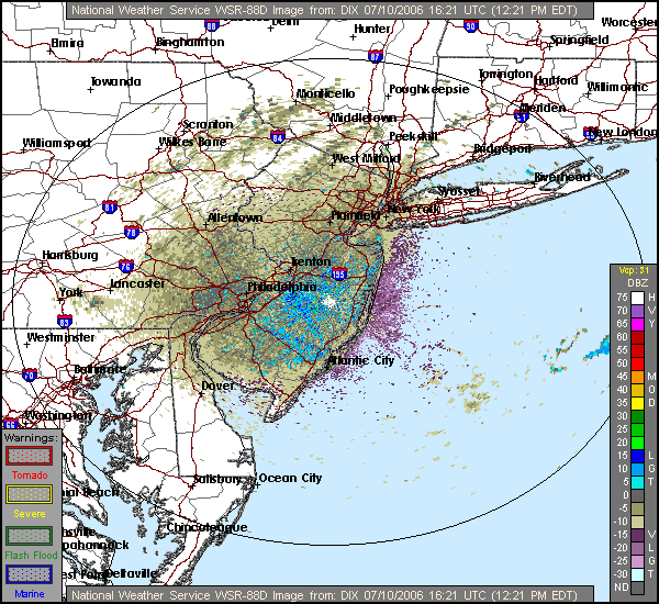
It's clutter that the radar picks up on, especially when it is in clear-air mode (as you can tell by the VCP: 31 above the key (VCP 32 is another clear-air mode)). If you look at that key, you will also see that the brown and purple stuff is negative returns, which is definately indication of no precipitation, as precipitation will always show as a positive return.
Basically, think of it as static on the radio. It, like a radio's static, is greatly amplified at night. In fact, when the radar goes into this mode, you can see some radars pick up on 65dBZ storms that "sit" over an area for hours on end and just grow in size. It's actually kind of entertaining to watch, especially knowing that there aren't even clouds within range of the radar.
Basically, think of it as static on the radio. It, like a radio's static, is greatly amplified at night. In fact, when the radar goes into this mode, you can see some radars pick up on 65dBZ storms that "sit" over an area for hours on end and just grow in size. It's actually kind of entertaining to watch, especially knowing that there aren't even clouds within range of the radar.
0 likes
-
angelwing
- S2K Supporter
- Posts: 4462
- Age: 64
- Joined: Tue Jan 18, 2005 3:06 pm
- Location: Kulpsville, PA
DEZ001-NJZ015-017>019-027-PAZ067>071-141715-
/O.COR.KPHI.EH.A.0001.060716T1200Z-060718T0000Z/
NEW CASTLE-MERCER-GLOUCESTER-CAMDEN-NORTHWESTERN BURLINGTON- SOUTHEASTERN BURLINGTON-CHESTER-MONTGOMERY-BUCKS-DE-
PHILADELPHIA-
INCLUDING THE CITIES OF.WILMINGTON.TRENTON.GLASSBORO.
CAMDEN.CHERRY HILL.MOORESTOWN.MOUNT HOLLY.
WHARTON STATE FOREST.WEST CHESTER.NORRISTOWN.DOYLESTOWN.
MEDIA
508 AM EDT FRI JUL 14 2006
.EXCESSIVE HEAT WATCH IN EFFECT FROM SUN MORNING THROUGH MONDAY EVENING.
THE NATL WEATHER SVC IN MOUNT HOLLY HAS ISSUED AN EXCESSIVE HEAT WATCH.WHICH IS IN EFFECT FROM SUN MORNING THROUGH MON EVENING.
A SPELL OF HOT & HUMID WEATHER IS EXPECTED THIS WEEKEND THROUGH AT LEAST EARLY NEXT WEEK. A LARGE AREA OF HIGH PRESSURE IN THE UPPER ATMOSPHERE OVER THE DESERT SW WILL BUILD SLOWLY EASTWARD OVER THE WEEKEND. BY TUESDAY, THIS HIGH WILL BE CENTERED OVER THE MIDWEST & OH VALLEY. WITH A GOOD DEAL OF MIDSUMMER SUNSHINE, & A FLOW OF SURFACE AIR FROM THE SOUTHWEST, AN IDEAL SITUATION FOR A SUMMER HEAT WAVE IS DEVELOPING FOR OUR NORTHERN MID ATLANTIC REGION. THE AIRMASS IN PLACE WILL ALSO OFFER A GOOD DEAL OF HUMIDITY.
THE COMBINATION OF EXPECTED HEAT & HUMIDITY MAY PRODUCE DANGEROUS HEAT INDICES LATER THIS WEEKEND & ESPECIALLY EARLY NEXT WEEK.
THE LATEST FORECAST INDICATES THAT HEAT INDICES WILL TOP OUT IN THE LWR TO MID 90S SAT AFTERNOON. DURING THE AFTERNOONS OF SUNDAY, MONDAY, & PERHAPS EVEN TUESDAY, HEAT INDICES ARE EXPECTED TO TOP OUT BETWEEN 105 & 110 DEGREES IN THE HIGHLY URBANIZED AREAS, INCLUDING THE CITY OF PHILADELPHIA AND SURROUNDING COUNTIES. ADDING TO THE DISCOMFORT IS THE FACT THAT NIGHTTIME LOW TEMPS MAY NOT FALL MUCH OVER URBAN LOCATIONS.
AN EXCESSIVE HEAT WATCH MEANS THAT A PROLONGED PERIOD OF HOT TEMPS IS EXPECTED. THE EXPECTED COMBINATION OF HOT TEMPS & HIGH HUMIDITIES, IF THEY ACTUALLY OCCUR, WILL COMBINE TO CREATE A DANGEROUS SITUATION IN WHICH HEAT ILLNESSES ARE POSSIBLE, ESPECIALLY SINCE THIS WILL BE THE FIRST MEANINGFUL HEAT WAVE THIS SUMMER.
BE PREPARED TO DEAL WITH THIS POSSIBLY EXTENDED PERIOD OF EXCESSIVE HEAT BY REVIEWING COMMON SENSE SAFETY TIPS. WEAR LOOSE FITTING & LIGHT COLORED CLOTHING. DRINK PLENTY OF NON-ALCOHOLIC BEVERAGES TO AVOID DEHYDRATION. AVOID STRENUOUS ACTIVITIES DURING THE HOTTEST PART OF THE DAY, WHICH IS MID & LATE AFTERNOON. MAKE SURE YOUR DWELLING IS VENTILATED; USE A FAN, OR GET ONE IF YOU DO NOT HAVE ONE. SPEND TIME IN AN AIR CONDITIONED BUILDING, IF POSSIBLE, TO KEEP COOL DURING THE HOT & SULTRY WEATHER. CHECK ON THE ELDERLY, INFIRM, & VERY YOUNG, AS THEY ARE MOST VULNERABLE TO THE HEAT. MAKE PROVISIONS FOR PETS & ANIMALS BY INSURING THEY HAVE PLENTY OF COOL WATER TO DRINK & SHADE IN WHICH TO REST.
STAY TUNED TO NOAA WEATHER RADIO ALL HAZARDS, OR YOUR LOCAL MEDIA OUTLET, FOR UPDATES ON THIS DEVELOPING EXTENDED PERIOD OF EXCESSIVE HEAT, INCLUDING THE POSSIBLE ISSUANCE OF AN EXCESSIVE HEAT WARNING OR HEAT ADVISORY.
0 likes
-
angelwing
- S2K Supporter
- Posts: 4462
- Age: 64
- Joined: Tue Jan 18, 2005 3:06 pm
- Location: Kulpsville, PA
Updated..... 
EZ001-NJZ015-017>019-027-PAZ067>071-151000-
/O.EXT.KPHI.EH.A.0001.060716T1700Z-060719T0100Z/
NEW CASTLE-MERCER-GLOUCESTER-CAMDEN-NORTHWESTERN BURLINGTON- SOUTHEASTERN BURLINGTON-CHESTER-MONTGOMERY-BUCKS-DE-
PHILADELPHIA-
INCLUDING THE CITIES OF.WILMINGTON.TRENTON.GLASSBORO.
CAMDEN.CHERRY HILL.MOORESTOWN.MOUNT HOLLY.
WHARTON STATE FOREST.WEST CHESTER.NORRISTOWN.DOYLESTOWN.
MEDIA
358 PM EDT FRI JUL 14 2006
.EXCESSIVE HEAT WATCH NOW IN EFFECT FROM SUN AFTERNOON THROUGH TUES EVENING.
THE EXCESSIVE HEAT WATCH IS NOW IN EFFECT FROM SUN AFTERNOON THROUGH TUES EVENING.
A SPELL OF HOT & HUMID WEATHER IS EXPECTED THIS WEEKEND THROUGH AT LEAST EARLY NEXT WEEK. A LARGE AREA OF HIGH PRESSURE IN THE UPPER ATMOSPHERE OVER THE DESERT SW INTO THE CNTL PLAINS WILL EXPAND SLOWLY EASTWARD OVER THE WEEKEND. BY TUES AFTERNOON, THIS HIGH WILL BE CENTERED OVER THE OH VALLEY. THIS WILL USHER IN A HOTTER AIRMASS AS WE GO THROUGH THE WEEKEND, & ESPECIALLY DURING THE FIRST PART OF NEXT WEEK. THERE IS THE POTENTIAL THIS PERIOD OF EXCESSIVE HEAT LINGERS THROUGH MUCH OF NEXT WEEK.
THE COMBINATION OF THE EXPECTED HEAT & HUMIDITY MAY PRODUCE DANGEROUS HEAT INDICES LATE THIS WEEKEND, & ESPECIALLY DURING EARLY NEXT WEEK.
THE LATEST FORECAST INDICATES THAT HEAT INDICES WILL TOP OUT AROUND 90 DEGREES SAT AFTERNOON. DURING SUN AFTERNOON, HEAT INDICES ARE EXPECTED TO BE AROUND 100 DEGREES, & FOR MON & TUES AFTERNOONS, THE HEAT INDICES ARE EXPECTED TO TOP OUT AROUND 105 DEGREES IN THE HIGHLY URBANIZED AREAS, INCLUDING THE CITY OF PHILADELPHIA & SURROUNDING COUNTIES. ADDING TO THE DISCOMFORT IS THE FACT THAT NIGHTTIME LOW TEMPS MAY NOT FALL MUCH OVER THE URBAN LOCATIONS.
AN EXCESSIVE HEAT WATCH MEANS THAT A PROLONGED PERIOD OF HOT TEMPS IS EXPECTED. THE EXPECTED COMBINATION OF HOT TEMPS & HIGH HUMIDITY LEVELS, WILL COMBINE TO CREATE A DANGEROUS SITUATION, IN WHICH HEAT ILLNESSES ARE POSSIBLE.
BE PREPARED TO DEAL WITH THIS ANTICIPATED EXTENDED PERIOD OF EXCESSIVE HEAT BY REVIEWING SAFETY TIPS. WEAR LOOSE FITTING & LIGHT COLORED CLOTHING, & DRINK PLENTY OF NON-ALCOHOLIC BEVERAGES TO AVOID DEHYDRATION. AVOID STRENUOUS ACTIVITIES DURING THE HOTTEST PART OF THE DAY, WHICH IS TYPICALLY BETWEEN 2 PM & 5 PM. MAKE SURE YOUR BUILDING IS VENTILATED BY USING A FAN, OR GET ONE IF YOU DO NOT HAVE ONE. SPEND TIME IN AN AIR CONDITIONED BUILDING, IF POSSIBLE, TO KEEP COOL DURING THE HOT WEATHER.
CHECK ON THE ELDERLY, THE INFIRM, & THE VERY YOUNG, AS THEY ARE MOST VULNERABLE TO THE HEAT. MAKE PROVISIONS FOR PETS & ANIMALS BY INSURING THEY HAVE PLENTY OF COOL WATER TO DRINK & SHADE IN WHICH TO REST. IF POSSIBLE, THE BEST THING TO DO IS TO BRING THEM INDOORS INTO AN AIR CONDITIONED ENVIRONMENT.
PLEASE DO NOT LEAVE ANY CHILD OR ANIMAL UNATTENDED IN A VEHICLE FOR ANY LENGTH OF TIME. VEHICLES, EVEN VEHICLES WITH THEIR WINDOWS OPEN SLIGHTLY, CAN BECOME EXTREMELY HOT, DEATH TRAPS VERY QUICKLY.
STAY TUNED TO NOAA WEATHER RADIO ALL HAZARDS, OR YOUR LOCAL MEDIA OUTLET FOR UPDATES ON THIS DEVELOPING EXTENDED PERIOD OF EXCESSIVE HEAT, INCLUDING THE POSSIBLE ISSUANCE OF AN EXCESSIVE HEAT WARNING OR HEAT ADVISORY.
$$
GORSE/OHARA
0 likes
Return to “USA & Caribbean Weather”
Who is online
Users browsing this forum: No registered users and 116 guests