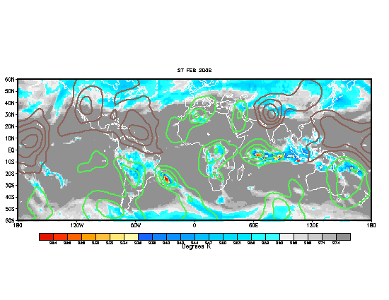
Mets or anyone else help me what this is?
Moderator: S2k Moderators
Forum rules
The posts in this forum are NOT official forecasts and should not be used as such. They are just the opinion of the poster and may or may not be backed by sound meteorological data. They are NOT endorsed by any professional institution or STORM2K. For official information, please refer to products from the National Hurricane Center and National Weather Service.
Mets or anyone else help me what this is?
Help explaining what this is? Does have any effect on tropical activity. It looks like green its more favorable for cyclones and brown its the opposite. When Chris first emerge it was in green and then as soon the brown moved east slowed down chris. Looks like the green lines are moving back west towards the Atlantic.


Last edited by Trugunzn on Sat Aug 05, 2006 2:11 pm, edited 1 time in total.
0 likes
- vacanechaser
- Category 5

- Posts: 1461
- Joined: Wed Dec 03, 2003 9:34 pm
- Location: Portsmouth, Va
- Contact:
it is a map that depicts the MJO, or Madden julien oscilation.... the green shows positive areas for development... in other words, upward motion... the brown is negative for developemnt, or downward motion.... right now, just the eastern atlantic is in positive or upward motion..
Jesse V. Bass III
http://www.vastormphoto.com
hurricane Intercept Research Team
Jesse V. Bass III
http://www.vastormphoto.com
hurricane Intercept Research Team
0 likes
-
willjnewton
- vacanechaser
- Category 5

- Posts: 1461
- Joined: Wed Dec 03, 2003 9:34 pm
- Location: Portsmouth, Va
- Contact:
Trugunzn wrote:U think this is part of the reason for Chris weaking
i dont think so... if i remember correctly, once something develops, it should maintain...
chris likely weakened due to upper level shear... it is caught between to upper lows and they pulled it apart
Jesse V. Bass III
http://www.vastormphoto.com
Hurricane Intercept Research Team
0 likes
- KFDM Meteorologist
- Professional-Met

- Posts: 1314
- Joined: Tue May 16, 2006 9:52 pm
- Location: Upper Texas Coast/Orange County
Re: Mets or anyone else help me what this is?
Trugunzn wrote:Help explaining what this is? Does have any effect on tropical activity. It looks like green its more favorable for cyclones and brown its the opposite. When Chris first emerge it was in green and then as soon the brown moved east slowed down chris. Looks like the green lines are moving back west towards the Atlantic.
This is analysis of the amount of outgoing longwave radiation (OLR)...which is a fancy way of saying this is a satellite estimate of how much heat is getting radiated back into the atmosphere.
Clouds insulate the earth, as we know. Cloudless winter nights let heat radiate out into space all night. Cloudy nights retain heat, keeping the lower atmosphere warmer for example.
So, if there are more clouds present in the tropical atmosphere, the less longwave radiation is making it into space.
More clouds means more convection...so measuring the difference between the normal amount of OLR and the actual OLR...the areas where there are more thinderstorms present are thought to be convectively enhanced by the "MJO"...and the relatively less coudy areas are convectively less active.
These anoms typically move left to right across the map with a cycle of 20 to 30 days...but it doesn't always work that way.
x-y-no wrote:Also, keep in mind that the effect of the MJO on tropical cyclones is not well established, particularly in the Atlantic basin.
It's more of an hypothesis right now, rather than a theory.
I completely agree with Jan here on this...sometimes it's hard to tell if the convection is the chicken or the egg...
MW
0 likes
Updating on the twitter now: http://www.twitter.com/@watkinstrack
Who is online
Users browsing this forum: Google [Bot] and 58 guests


