Derek Ortt wrote:Who has responsibility for this area, or is the Medeterranean considered part of the Atlantic?
Greece cover this area, although Meteo-France prepare the western half of the Mediterranean (Still within MetArea III).
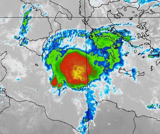
http://weather.gmdss.org/image/metarea3.jpg It can't really be part of the North Atlantic as that would be MetArea I, II, IV, or V. Met Office analysis chart is
here, which has it as a 1006hPa low as of 1200 GMT. Nearer to that quickscat image is the 0000 GMT analysis at
http://www.wetterzentrale.de/archive/2006/brack/bracka20061016.gif.
WWME22 LGAT 161930
NATIONAL METEOROLOGICAL SERVICE
ATHENS MARINE METEOROLOGICAL CENTRE
TTT GALE WARNING 16-10-06 / 1930 UTC
VALID FROM 162200 UTC UP TO 171000 UTC
HIGH PRESSURES 1025 OVER NORTH BALKANS ARE COMBINED WITH BAROMETRIC
LOW 1012 OVER BLACK SEA WHILE ANOTHER BAROMETRIC LOW 1007 OVER SIDRA
IS DEPENING MOVING SLOWLY EASTWARDS AFFECTING :
BOOT WITH NORTH NORTHEAST NEAR GALE 7 LOCALLY GALE 8
SIDRA WITH CYCLONIC NEAR GALE 7 LOCALLY GALE 8 AND FROM 170000 UTC
NORTH OF 34.00 WITH NORTH NORTHEAST GALE 8 LOCALLY STRONG GALE 9 AND
SOUTH OF 34.00 WITH NORTHWEST GALE 8
SOUTH IONIO SOUTH OF 37.00 WITH EAST NORTHEAST NEAR GALE 7 LOCALLY
GALE 8 AND FROM 170400 UTC NORTHEAST GALE 8 LOCALLY STRONG GALE 9
FROM 170400 UTC SOUTH IONIO NORTH OF 37.00 WITH NORTHEAST NEAR GALE
7 UP TO GALE 8
KITHIRA SEA WITH EAST NORTHEAST NEAR GALE 7 LOCALLY GALE 8 AND FROM
170400 UTC WITH NORTHEAST STRONG GALE 9
SOUTHWEST KRITIKO WITH CYCLONIC WEST OF 23.30 GALE 8 LOCALLY STRONG
GALE 9 AND FROM 170400 UTC WEST OF 23.30 STRONG GALE 9 AND EAST OF
23.30 NEAR GALE 7 LOCALLY GALE 8
FROM 170400 UTC WEST KRITIKO SOUTHWEST AEGEAN AND SOUTHEAST AEGEAN
IKARIO WEST OF 24.30 WITH NORTHEAST NEAR GALE 7 LOCALLY GALE 8
WEST BLACK SEA WEST OF 32.00 WITH NORTH NEAR GALE 7 LOCALLY GALE 8=


