The February 4-8, 2007 Arctic Outbreak: Some Thoughts

Winter Weather Discussion

Moderator: S2k Moderators

Forum rules

The posts in this forum are NOT official forecast and should not be used as such. They are just the opinion of the poster and may or may not be backed by sound meteorological data. They are NOT endorsed by any professional institution or STORM2K.

Help Support Storm2K
Message
Author
donsutherland1
S2K Analyst
S2K Analyst
Posts: 2718
Joined: Mon Sep 15, 2003 8:49 pm
Location: New York

The February 4-8, 2007 Arctic Outbreak: Some Thoughts

#1 Postby donsutherland1 » Sat Jan 27, 2007 6:40 pm

The NCEP ensemble 500 mb anomalies forecast for 240 hours (2/6 0z) strongly resemble those that were present in North America during several outbreaks of severe cold that occurred in the January 25-February 15 timeframe. Based on historic precedent, I believe this Arctic outbreak will prove to be the worst of Winter 2006-07.

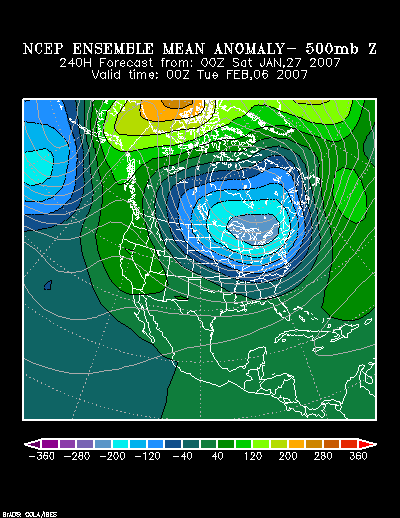
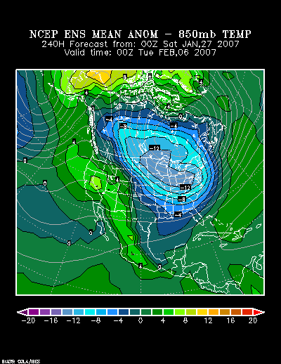
NCEP Ensemble 500 mb Anomalies at 240 hours:
Image

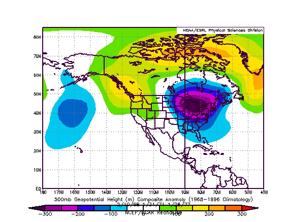
Composite Analog 500 mb Anomalies:
Image

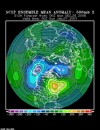
What a difference a month makes!

The following were the NCEP Ensemble 500 mb Anomalies forecast for 312 hours from December 25, 2006:

Image

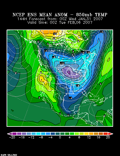
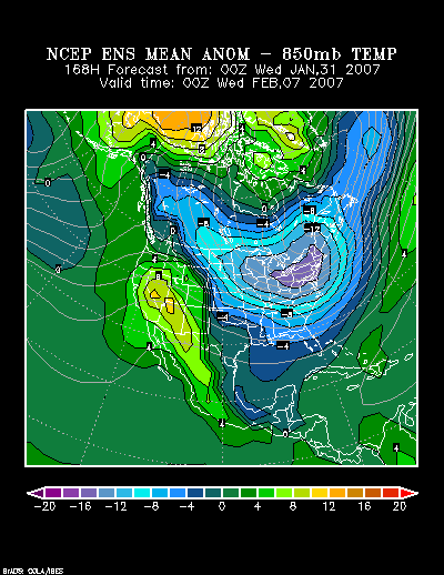
The NCEP Ensemble mean 850 mb temperature forecast for 240 hours shows a large area of 8°C-12°C (14.4F-21.6F) below normal temperatures.

Image

In terms of standard deviations, there is a large area of cold that is 1.5 or more standard deviations below normal. The Canadian Ensemble 10-day forecast posted on January 27 also shows a large area of cold that is in the range of 1.5 to 1.75 standard deviations below normal:

Image

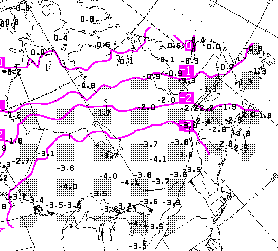
Note: Each contour on the above map is the equivalent of 0.43 standard deviations e.g., “3” = 1.29 standard deviations (0.43*3).

During the three analog periods from which the 500 mb composite analog was constructed, the lowest temperature reached in select cities was:

February 10-14, 1968:
Atlanta: 15°
Boston: 9°
Burlington: -13°
Detroit: 5°
Indianapolis: 4°
New York City: 8°
Philadelphia: 10°
Raleigh: 8°
Richmond: 8°
Washington, DC (DCA): 12°

January 31-February 3, 1971:
Atlanta: 16°
Boston: 5°
Burlington: -25°
Detroit: -9°
Indianapolis: -5°
New York City: 6°
Philadelphia: 6°
Raleigh: 5°
Richmond: 3°
Washington, DC (DCA): 11°

January 28-February 2, 1977:
Atlanta: 8°
Boston: 7°
Burlington: -8°
Detroit: -8°
Indianapolis: -11°
New York City: 1°
Philadelphia: 1°
Raleigh: 7°
Richmond: 11°
Washington, DC (DCA): 8°

At this time, with some modification for the smaller area of severe cold over the past 30 days relative to what existed before these outbreaks, readings just a little above those noted above should be seen as offering some insight into the potential magnitude of the 2/4-8 cold period at its coldest: -12° or below in Burlington, 2° or below in Detroit, and 5° or below in Indianapolis. Both Detroit and Indianapolis could have one or more subzero lows. Boston, New York City, and Philadelphia should see one or more low temperatures in the single digits. Of those three cities, Boston might have a chance to achieve a subzero low based on climatology and not the above historic Arctic outbreaks. In New York City, such a low is very unlikely. In Washington, DC and Richmond the lowest temperature should come to 14° or lower. Raleigh should see a minimum temperature in the teens or lower and a single-digit low is possible. Atlanta should see a minimum temperature in the teens.

In short, a number of the above cities will likely see their coldest readings of the winter. For purposes of comparison, the coldest temperatures for Winter 2006-07 for the above cities are:

Atlanta: 19°
Boston: 3°
Burlington: -15°
Detroit: 8°
Indianapolis: 7°
New York City: 9°
Philadelphia: 10°
Raleigh: 16°
Richmond: 17°
Washington, DC (DCA): 15°
0 likes   

User avatar
angelwing
S2K Supporter
S2K Supporter
Posts: 4462
Age: 63
Joined: Tue Jan 18, 2005 3:06 pm
Location: Kulpsville, PA

#2 Postby angelwing » Sat Jan 27, 2007 8:38 pm

Thank you Don, very informative as always!
0 likes   

User avatar
tbstorm
Tropical Storm
Tropical Storm
Posts: 135
Joined: Sun Oct 09, 2005 7:33 pm
Location: St. Petersburg, FL

#3 Postby tbstorm » Sat Jan 27, 2007 9:12 pm

Your analyses have been on the money for January...
care to comment on this cold blast in terms of what you expect for Florida (Tampa)?
0 likes   

User avatar
TeeBird
Tropical Low
Tropical Low
Posts: 15
Joined: Sat Jan 22, 2005 3:51 pm
Location: Warrenton, VA

Winter cold . . . .

#4 Postby TeeBird » Sat Jan 27, 2007 9:19 pm

Thanks for your analysis Don - as always right on the money!

It's been pretty cold here in NoVa - my poor tulips popped up in January and are probably wondering what is going on!

But.... whom do I have to pay to get some snow in here?! My black lab is missing frolicking in the banks.
0 likes   

donsutherland1
S2K Analyst
S2K Analyst
Posts: 2718
Joined: Mon Sep 15, 2003 8:49 pm
Location: New York

#5 Postby donsutherland1 » Sat Jan 27, 2007 9:23 pm

Thanks Tbstorm.

Florida is a tough call. I'm not yet certain Florida receives a direct shot of the Arctic air. If I had to venture a guess, I'd speculate that Tampa will likely see a low in the 38°-43° range at its coldest.
0 likes   

donsutherland1
S2K Analyst
S2K Analyst
Posts: 2718
Joined: Mon Sep 15, 2003 8:49 pm
Location: New York

#6 Postby donsutherland1 » Sat Jan 27, 2007 9:24 pm

Thanks Angelwing.
0 likes   

donsutherland1
S2K Analyst
S2K Analyst
Posts: 2718
Joined: Mon Sep 15, 2003 8:49 pm
Location: New York

Re: Winter cold . . . .

#7 Postby donsutherland1 » Sat Jan 27, 2007 9:29 pm

TeeBird,

A lot of the flowers that popped up prematurely in the New York Tri-State area (daffodils, some cherry trees, etc.) have been decimated by the cold. Some cherry trees had burst into bloom as far north as Boston:

Image

Hopefully, as the subtropical jet grows more active down the road, the threat of snow will return. Certainly, I believe there will be opportunities.
0 likes   

Air Force Met
Military Met
Military Met
Posts: 4372
Age: 56
Joined: Tue Jul 08, 2003 9:30 am
Location: Roan Mountain, TN

#8 Postby Air Force Met » Sat Jan 27, 2007 9:32 pm

donsutherland1 wrote:Scatboy,

It will be verified when all is said and done. Also, the sun is not materially higher than the earlier timeframes chosen and it is lower than the 1968 one.


Your so nice...and I'm so mean. :lol:
0 likes   

User avatar
Aquawind
Category 5
Category 5
Posts: 6714
Age: 61
Joined: Mon Jun 16, 2003 10:41 pm
Location: Salisbury, NC
Contact:

#9 Postby Aquawind » Sat Jan 27, 2007 9:36 pm

Your both right on.. as usual.. 8-)
0 likes   

cpdaman
Category 5
Category 5
Posts: 3131
Joined: Sat Jun 10, 2006 11:44 am
Location: SPB county (gulf stream)

#10 Postby cpdaman » Sat Jan 27, 2007 11:56 pm

DON a certain pro weather site is calling for lows tue morning of 29 in orlando in the current cold shot, and 36 for tampa so i would think that 38-43 is on the conservative side considering this forecast was for the following week with a cooler system
0 likes   

User avatar
TampaFl
S2K Supporter
S2K Supporter
Posts: 1904
Age: 67
Joined: Thu Sep 04, 2003 11:23 am
Location: Tampa, FL

#11 Postby TampaFl » Sun Jan 28, 2007 6:29 am

cpdaman wrote:DON a certain pro weather site is calling for lows tue morning of 29 in orlando in the current cold shot, and 36 for tampa so i would think that 38-43 is on the conservative side considering this forecast was for the following week with a cooler system


Cpdaman, I would go with what Don says. He has a real good handle on this. Does look rather "chilly" especially Tuesday morning. I have noted that this winter all the computer models have been bisaed cold on the low temps for our area this winter. Case in point the low for Tampa Friday morning (1/26) was 42 when the NWS forcasted a low of 39! & Tallahassee was forcasted @ 24 & they only got down to 28! , and that was without cloud cover. Plus most computer models have at least 3 - 5 degrees bias cold this winter on Central Fl min. temps. One good thing though, is we are finally getting some rain, more typical of an EL NINO winter. Here is the latest run of the GFSX MOS forcasted temps for Orlando & Tampa. Compare what it has for Orlando, then see NWS forcast for Orlando.

GFSX MOS FORECASTS


--------------------------------------------------------------------------------

KMCO GFSX MOS GUIDANCE 1/28/2007 0000 UTC
FHR 24| 36 48| 60 72| 84 96|108 120|132 144|156 168|180 192
SUN 28| MON 29| TUE 30| WED 31| THU 01| FRI 02| SAT 03| SUN 04 CLIMO
X/N 68| 39 55| 32 59| 38 61| 48 74| 61 84| 63 72| 52 72 49 72
TMP 58| 39 45| 35 50| 40 53| 50 66| 63 74| 65 64| 53 63
DPT 45| 26 21| 26 26| 32 40| 49 59| 63 66| 63 57| 50 53
CLD OV| CL CL| CL CL| CL OV| OV OV| OV OV| OV OV| OV OV
WND 19| 14 12| 5 6| 9 9| 6 8| 11 19| 15 16| 14 14
P12 13| 8 6| 10 16| 12 24| 31 33| 16 29| 35 31| 27 17 13 18
P24 | 8| 16| 29| 43| 29| 53| 40 24
Q12 0| 0 0| 0 0| 0 0| 1 1| 0 0| 2 |
Q24 | 0| 0| 0| 1| 0| |
T12 2| 0 0| 1 0| 2 3| 5 5| 4 12| 17 12| 4 4
T24 | 2 | 1 | 2 | 6 | 7 | 27 | 16


--------------------------------------------------------------------------------

KTPA
GFSX MOS GUIDANCE 1/28/2007 0000 UTC
FHR 24| 36 48| 60 72| 84 96|108 120|132 144|156 168|180 192
SUN 28| MON 29| TUE 30| WED 31| THU 01| FRI 02| SAT 03| SUN 04 CLIMO
X/N 67| 39 54| 34 62| 44 62| 51 75| 63 80| 66 73| 52 71 50 70
TMP 57| 40 43| 37 52| 45 55| 53 68| 65 72| 67 64| 54 63
DPT 48| 27 26| 27 35| 39 43| 51 60| 64 67| 64 59| 49 52
CLD OV| CL CL| CL CL| OV OV| OV OV| OV OV| OV OV| OV OV
WND 17| 12 9| 5 7| 6 7| 7 7| 12 14| 14 14| 10 8
P12 10| 7 5| 9 16| 17 27| 29 26| 12 29| 32 31| 25 16 14 15
P24 | 7| 16| 33| 37| 29| 54| 39 23
Q12 0| 0 0| 0 0| 0 0| 1 0| 0 0| 1 |
Q24 | 0| 0| 0| 1| 0| |
T12 1| 0 0| 0 0| 2 3| 5 4| 5 12| 17 13| 4 3
T24 | 1 | 0 | 2 | 7 | 6 | 29 | 16

NWS MLB Orlando Forcast:


http://www.srh.noaa.gov/forecast/MapClick.php?site=tbw&map.x=222&map.y=94
0 likes   

Fodie77
Tropical Storm
Tropical Storm
Posts: 210
Joined: Tue Aug 31, 2004 4:21 pm

#12 Postby Fodie77 » Sun Jan 28, 2007 6:38 pm

Any possibility of snow for us here in the New River Valley during that time frame? SW Virginia has been itching for some snow for a while now.
0 likes   

User avatar
Extremeweatherguy
Category 5
Category 5
Posts: 11095
Joined: Mon Oct 10, 2005 8:13 pm
Location: Florida

#13 Postby Extremeweatherguy » Sun Jan 28, 2007 10:32 pm

TampaFl wrote:
cpdaman wrote:DON a certain pro weather site is calling for lows tue morning of 29 in orlando in the current cold shot, and 36 for tampa so i would think that 38-43 is on the conservative side considering this forecast was for the following week with a cooler system


Cpdaman, I would go with what Don says. He has a real good handle on this. Does look rather "chilly" especially Tuesday morning. I have noted that this winter all the computer models have been bisaed cold on the low temps for our area this winter. Case in point the low for Tampa Friday morning (1/26) was 42 when the NWS forcasted a low of 39! & Tallahassee was forcasted @ 24 & they only got down to 28! , and that was without cloud cover. Plus most computer models have at least 3 - 5 degrees bias cold this winter on Central Fl min. temps. One good thing though, is we are finally getting some rain, more typical of an EL NINO winter. Here is the latest run of the GFSX MOS forcasted temps for Orlando & Tampa. Compare what it has for Orlando, then see NWS forcast for Orlando.

GFSX MOS FORECASTS


--------------------------------------------------------------------------------

KMCO GFSX MOS GUIDANCE 1/28/2007 0000 UTC
FHR 24| 36 48| 60 72| 84 96|108 120|132 144|156 168|180 192
SUN 28| MON 29| TUE 30| WED 31| THU 01| FRI 02| SAT 03| SUN 04 CLIMO
X/N 68| 39 55| 32 59| 38 61| 48 74| 61 84| 63 72| 52 72 49 72
TMP 58| 39 45| 35 50| 40 53| 50 66| 63 74| 65 64| 53 63
DPT 45| 26 21| 26 26| 32 40| 49 59| 63 66| 63 57| 50 53
CLD OV| CL CL| CL CL| CL OV| OV OV| OV OV| OV OV| OV OV
WND 19| 14 12| 5 6| 9 9| 6 8| 11 19| 15 16| 14 14
P12 13| 8 6| 10 16| 12 24| 31 33| 16 29| 35 31| 27 17 13 18
P24 | 8| 16| 29| 43| 29| 53| 40 24
Q12 0| 0 0| 0 0| 0 0| 1 1| 0 0| 2 |
Q24 | 0| 0| 0| 1| 0| |
T12 2| 0 0| 1 0| 2 3| 5 5| 4 12| 17 12| 4 4
T24 | 2 | 1 | 2 | 6 | 7 | 27 | 16


--------------------------------------------------------------------------------

KTPA
GFSX MOS GUIDANCE 1/28/2007 0000 UTC
FHR 24| 36 48| 60 72| 84 96|108 120|132 144|156 168|180 192
SUN 28| MON 29| TUE 30| WED 31| THU 01| FRI 02| SAT 03| SUN 04 CLIMO
X/N 67| 39 54| 34 62| 44 62| 51 75| 63 80| 66 73| 52 71 50 70
TMP 57| 40 43| 37 52| 45 55| 53 68| 65 72| 67 64| 54 63
DPT 48| 27 26| 27 35| 39 43| 51 60| 64 67| 64 59| 49 52
CLD OV| CL CL| CL CL| OV OV| OV OV| OV OV| OV OV| OV OV
WND 17| 12 9| 5 7| 6 7| 7 7| 12 14| 14 14| 10 8
P12 10| 7 5| 9 16| 17 27| 29 26| 12 29| 32 31| 25 16 14 15
P24 | 7| 16| 33| 37| 29| 54| 39 23
Q12 0| 0 0| 0 0| 0 0| 1 0| 0 0| 1 |
Q24 | 0| 0| 0| 1| 0| |
T12 1| 0 0| 0 0| 2 3| 5 4| 5 12| 17 13| 4 3
T24 | 1 | 0 | 2 | 7 | 6 | 29 | 16

NWS MLB Orlando Forcast:


http://www.srh.noaa.gov/forecast/MapClick.php?site=tbw&map.x=222&map.y=94


Just so you know, for low temperatures you should actually be looking above the TMP coloumn and to the X/N coloumn (X = Max, N = Min). The 00z MOS forecast low for Orlando was actually 32 and in Tampa it is 34.

Since then, the 12z MOS is now showing a low of 31 for Orlando and 36 for Tampa.

Overall, it still looks like central Florida will see it's coldest morning of the year (so far at least) on Tuesday. Tampa may be spared a freeze, but Orlando will be a much closer call.
Last edited by Extremeweatherguy on Sun Jan 28, 2007 10:37 pm, edited 1 time in total.
0 likes   

User avatar
ohiostorm
Category 5
Category 5
Posts: 1582
Age: 40
Joined: Sat Oct 12, 2002 2:51 pm
Location: Orlando, FL
Contact:

#14 Postby ohiostorm » Sun Jan 28, 2007 10:35 pm

What would be the lowest for Pittsburgh?
0 likes   

donsutherland1
S2K Analyst
S2K Analyst
Posts: 2718
Joined: Mon Sep 15, 2003 8:49 pm
Location: New York

#15 Postby donsutherland1 » Mon Jan 29, 2007 11:55 am

Ohiostorm,

I believe Pittsburgh will likely see one or two subzero nights with lows in the -6° to -1° range.
0 likes   

Stormcenter
S2K Supporter
S2K Supporter
Posts: 6677
Joined: Wed Sep 03, 2003 11:27 am
Location: Houston, TX

#16 Postby Stormcenter » Mon Jan 29, 2007 12:51 pm

What about the temperatures for the Houston and New Orleans areas during that time period? Thanks.
0 likes   

donsutherland1
S2K Analyst
S2K Analyst
Posts: 2718
Joined: Mon Sep 15, 2003 8:49 pm
Location: New York

#17 Postby donsutherland1 » Mon Jan 29, 2007 6:54 pm

Stormcenter,

The worst of the cold will likely pass to the north and east of Houston and New Orleans. I believe Houston will see its coldest reading in the 35°-40° range. At New Orleans, the coldest temperature will probably come to 30°-35°.
0 likes   

donsutherland1
S2K Analyst
S2K Analyst
Posts: 2718
Joined: Mon Sep 15, 2003 8:49 pm
Location: New York

#18 Postby donsutherland1 » Wed Jan 31, 2007 9:00 am

So far, even as the models show substantial volatility in trying to resolve the details of the February 1-2 storm, the cold shot for February 4-8 remains on track. The following are the ensemble mean 850 mb anomalies. In some locations, the anomalies are forecast to be 12°C-14°C (21.6°F-25.2°F) below normal. On February 6, 0z, there is a small area of 16°C (28.8°F) below normal 850 mb temperatures.

NCEP Ensemble mean 850 mb anomalies for February 6, 2007 0z:
Image

NCEP Ensemble mean 850 mb anomalies for February 6, 2007 0z:
Image

All said, I have a high degree of confidence in my initial thinking from the beginning of this thread, which follows:

At this time, with some modification for the smaller area of severe cold over the past 30 days relative to what existed before these outbreaks, readings just a little above those noted above should be seen as offering some insight into the potential magnitude of the 2/4-8 cold period at its coldest: -12° or below in Burlington, 2° or below in Detroit, and 5° or below in Indianapolis. Both Detroit and Indianapolis could have one or more subzero lows. Boston, New York City, and Philadelphia should see one or more low temperatures in the single digits. Of those three cities, Boston might have a chance to achieve a subzero low based on climatology and not the above historic Arctic outbreaks. In New York City, such a low is very unlikely. In Washington, DC and Richmond the lowest temperature should come to 14° or lower. Raleigh should see a minimum temperature in the teens or lower and a single-digit low is possible. Atlanta should see a minimum temperature in the teens.
0 likes   

donsutherland1
S2K Analyst
S2K Analyst
Posts: 2718
Joined: Mon Sep 15, 2003 8:49 pm
Location: New York

#19 Postby donsutherland1 » Thu Feb 08, 2007 9:30 am

Verification:

At this time, with some modification for the smaller area of severe cold over the past 30 days relative to what existed before these outbreaks, readings just a little above those noted above should be seen as offering some insight into the potential magnitude of the 2/4-8 cold period at its coldest: -12° or below in Burlington, 2° or below in Detroit, and 5° or below in Indianapolis. Both Detroit and Indianapolis could have one or more subzero lows. Boston, New York City, and Philadelphia should see one or more low temperatures in the single digits. Of those three cities, Boston might have a chance to achieve a subzero low based on climatology and not the above historic Arctic outbreaks. In New York City, such a low is very unlikely. In Washington, DC and Richmond the lowest temperature should come to 14° or lower. Raleigh should see a minimum temperature in the teens or lower and a single-digit low is possible. Atlanta should see a minimum temperature in the teens.

The Northeast proved warmer than I had anticipated, particularly in northern New England. The cold also did not penetrate quite as far south as I had expected. Nonetheless, Detroit, Indianapolis, New York City, Raleigh, Richmond, and Washington, DC saw their coldest readings of the winter. Philadelphia tied its coldest mark on two occasions during the February 4-8 timeframe. Detroit and Indianapolis each saw 3 subzero lows.

The coldest readings were:

Atlanta: 23°
Boston: 10°
Burlington: 0°
Detroit: -4°
Indianapolis: -5°
New York City: 8°
Philadelphia: 10°
Raleigh: 15°
Richmond: 12°
Washington, DC (DCA): 10°
0 likes   

User avatar
Stephanie
S2K Supporter
S2K Supporter
Posts: 23843
Age: 62
Joined: Thu Feb 06, 2003 9:53 am
Location: Glassboro, NJ

#20 Postby Stephanie » Thu Feb 08, 2007 8:25 pm

Factor in those wind chills and it was around zero or just below around here.

UNCLE!!! :eek:
0 likes   


Return to “Winter Weather”

Who is online

Users browsing this forum: No registered users and 83 guests