Florida-Deadly Tornado Outbreak Sumter,The Villages,N.Smyrna

U.S. & Caribbean Weather Discussions and Severe Weather Events

Moderator: S2k Moderators

Forum rules

The posts in this forum are NOT official forecast and should not be used as such. They are just the opinion of the poster and may or may not be backed by sound meteorological data. They are NOT endorsed by any professional institution or STORM2K.

Help Support Storm2K
Message
Author
User avatar
tbstorm
Tropical Storm
Tropical Storm
Posts: 135
Joined: Sun Oct 09, 2005 7:33 pm
Location: St. Petersburg, FL

Florida-Deadly Tornado Outbreak Sumter,The Villages,N.Smyrna

#1 Postby tbstorm » Thu Feb 01, 2007 5:49 pm

Well well just got in from work and we have a nice little severe weather event shaping up for Florida.

Good area of convergence on the front
Image

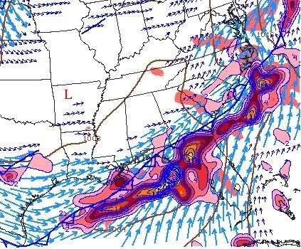
That's firing up a developing squall line over the north gulf
Image

Right now we have some strong storms south of Tallahassee, and also there is an interesting blow up in the gulf offshore Hernado/Citrus county.

Actually just checked the doppler.. there's a real NASTY looking storm offshore Citrus County

Image

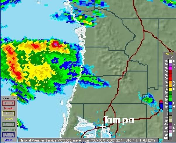
70db on that one... (purple). that's about the highest I have seen in Florida. It should be an exciting night!
Last edited by tbstorm on Fri Feb 02, 2007 8:41 am, edited 4 times in total.
0 likes   

jaxfladude
Category 5
Category 5
Posts: 1249
Joined: Wed Aug 24, 2005 9:36 pm
Location: Jacksonville, Fla

#2 Postby jaxfladude » Thu Feb 01, 2007 6:42 pm

Will Jax get any nasty weather tonight?
0 likes   

User avatar
ncupsscweather
Category 1
Category 1
Posts: 321
Age: 38
Joined: Tue Jan 02, 2007 8:05 pm
Location: Hickory,North Carolina

#3 Postby ncupsscweather » Thu Feb 01, 2007 6:46 pm

Tornado Watch
TORNADO WATCH OUTLINE UPDATE FOR WT 14
NWS STORM PREDICTION CENTER NORMAN OK
420 PM EST THU FEB 1 2007

TORNADO WATCH 14 IS IN EFFECT UNTIL 100 AM EST FOR THE
FOLLOWING LOCATIONS

GAC003-025-039-049-065-101-127-229-299-305-020600-
/O.NEW.KWNS.TO.A.0014.070201T2120Z-070202T0600Z/

GA
. GEORGIA COUNTIES INCLUDED ARE

ATKINSON BRANTLEY CAMDEN
CHARLTON CLINCH ECHOLS
GLYNN PIERCE WARE
WAYNE
$$

0 likes   

User avatar
tbstorm
Tropical Storm
Tropical Storm
Posts: 135
Joined: Sun Oct 09, 2005 7:33 pm
Location: St. Petersburg, FL

#4 Postby tbstorm » Thu Feb 01, 2007 7:00 pm

jaxfladude wrote:Will Jax get any nasty weather tonight?


I would say its definately a good possibility. JAX could get storms coming in off the gulf from the big bend area, and hold their intensity across N FL. The storm I was referring to above made it all the way past Ocala; though I did see a *decrease* in intensity as they moved inland off the gulf.

There's a line up there from Lake City to Waycross. Nothing severe yet, but I would think you could get some strong winds.
0 likes   

User avatar
tbstorm
Tropical Storm
Tropical Storm
Posts: 135
Joined: Sun Oct 09, 2005 7:33 pm
Location: St. Petersburg, FL

#5 Postby tbstorm » Thu Feb 01, 2007 7:01 pm

This was from that nasty looking storm I referred to up top....

NATIONAL WEATHER SERVICE TAMPA BAY AREA - RUSKIN FL
628 PM EST THU FEB 01 2007

0605 PM HAIL CRYSTAL RIVER

02/01/2007 E1.00 INCH CITRUS FL PUBLIC
QUARTER SIZE HAIL REPORTED ALONG HIGHWAY 19 IN CRYSTAL
RIVER.
0 likes   

User avatar
ncupsscweather
Category 1
Category 1
Posts: 321
Age: 38
Joined: Tue Jan 02, 2007 8:05 pm
Location: Hickory,North Carolina

#6 Postby ncupsscweather » Thu Feb 01, 2007 7:29 pm

What a way to start of the 1st day of February. Snow & Ice in the Mid-Atlantic States and Severe Weather in Southern Georgia and Florida.
0 likes   

jaxfladude
Category 5
Category 5
Posts: 1249
Joined: Wed Aug 24, 2005 9:36 pm
Location: Jacksonville, Fla

#7 Postby jaxfladude » Thu Feb 01, 2007 8:57 pm

http://en.wikipedia.org/wiki/Florida_El ... o_Outbreak

any chance of a repeat this year via El Niño??

Hope not.......
0 likes   

User avatar
tbstorm
Tropical Storm
Tropical Storm
Posts: 135
Joined: Sun Oct 09, 2005 7:33 pm
Location: St. Petersburg, FL

#8 Postby tbstorm » Thu Feb 01, 2007 10:10 pm

jaxfladude wrote:http://en.wikipedia.org/wiki/Florida_El_Ni%C3%B1o_Outbreak

any chance of a repeat this year via El Niño??

Hope not.......


Although I am not an expert in this, I dont think there is as much energy with this current line to produce a tornado like that.

Funny you mention that 1998 storm, I chased that storm down I-4 (it was always ahead of me). I have some video of the lightning from it, if I can dig it up. It was an awesome supercell. From what I remember the winds preceeding the storm (at least when it was here in Tampa) were much stronger than they are tonight. though it is quite breezy (~20mph) here

The El Nino of 98 is what really got me into severe storms, although I had been interested in weather for quite a while before that.
0 likes   

HurricaneBill
Category 5
Category 5
Posts: 3420
Joined: Sun Apr 11, 2004 5:51 pm
Location: East Longmeadow, MA, USA

#9 Postby HurricaneBill » Thu Feb 01, 2007 10:36 pm

0 likes   

User avatar
jdray
Category 3
Category 3
Posts: 853
Joined: Tue Aug 31, 2004 10:07 pm
Location: NE Florida

#10 Postby jdray » Thu Feb 01, 2007 10:36 pm

Duval
Clay
St Johns

all under a tornado watch till 1AM

pretty much Tampa to Jax just north of Orlando is under a watch.
0 likes   

User avatar
NDG
S2K Supporter
S2K Supporter
Posts: 15446
Joined: Sun Jul 09, 2006 10:14 pm
Location: Orlando, FL

#11 Postby NDG » Thu Feb 01, 2007 11:03 pm

Areas around Ocala are getting the rainfall that they have missed on so far this winter, I hope they don't get any major flooding out of this.
0 likes   

Rainband

#12 Postby Rainband » Thu Feb 01, 2007 11:26 pm

Tornado warning till 1145 for levy.
0 likes   

User avatar
ncupsscweather
Category 1
Category 1
Posts: 321
Age: 38
Joined: Tue Jan 02, 2007 8:05 pm
Location: Hickory,North Carolina

#13 Postby ncupsscweather » Thu Feb 01, 2007 11:34 pm

HurricaneBill that is an amazing video.
0 likes   

User avatar
ncupsscweather
Category 1
Category 1
Posts: 321
Age: 38
Joined: Tue Jan 02, 2007 8:05 pm
Location: Hickory,North Carolina

#14 Postby ncupsscweather » Thu Feb 01, 2007 11:36 pm

Tornado Warning
TORNADO WARNING
FLC083-020515-
/O.NEW.KJAX.TO.W.0002.070202T0426Z-070202T0515Z/

BULLETIN - EAS ACTIVATION REQUESTED
TORNADO WARNING
NATIONAL WEATHER SERVICE JACKSONVILLE FL
1126 PM EST THU FEB 1 2007

THE NATIONAL WEATHER SERVICE IN JACKSONVILLE HAS ISSUED A

* TORNADO WARNING FOR...
MARION COUNTY IN NORTHERN FLORIDA

* UNTIL 1215 AM EST

* AT 1122 PM EST...NATIONAL WEATHER SERVICE DOPPLER RADAR INDICATED A
SEVERE THUNDERSTORM CAPABLE OF PRODUCING A TORNADO 13 MILES
SOUTHWEST OF RAINBOW LAKES ESTATES...OR ABOUT 6 MILES NORTH OF
CRYSTAL RIVER...MOVING NORTHEAST AT 65 MPH.

* THE TORNADO IS WILL BE NEAR...
DUNNELLON BY 1135 PM EST...
OCALA AIRPORT BY 1140 PM EST...
OCALA AND SANTOS BY 1145 PM EST...
SILVER SPRINGS SHORES... LAKE WEIR AND WEIRSDALE BY 1150 PM
EST...
LYNNE... MOSS BLUFF AND OCKLAWAHA BY 1155 PM EST...

WHEN A TORNADO WARNING IS ISSUED BASED ON DOPPLER RADAR...IT MEANS
THAT STRONG ROTATION HAS BEEN DETECTED IN THE STORM. A TORNADO MAY
ALREADY BE ON THE GROUND...OR IS EXPECTED TO DEVELOP SHORTLY. IF YOU
ARE IN THE PATH OF THIS DANGEROUS STORM...MOVE INDOORS AND TO THE
LOWEST LEVEL OF THE BUILDING. STAY AWAY FROM WINDOWS. IF DRIVING...DO
NOT SEEK SHELTER UNDER A HIGHWAY OVERPASS.

SEEK SHELTER ON THE LOWEST FLOOR OF THE BUILDING IN AN INTERIOR
HALLWAY OR ROOM SUCH AS A CLOSET. USE BLANKETS OR PILLOWS TO COVER
YOUR BODY AND ALWAYS STAY AWAY FROM WINDOWS.

IF IN MOBILE HOMES OR VEHICLES...EVACUATE THEM AND GET INSIDE A
SUBSTANTIAL SHELTER. IF NO SHELTER IS AVAILABLE...LIE FLAT IN THE
NEAREST DITCH OR OTHER LOW SPOT AND COVER YOUR HEAD WITH YOUR HANDS.

REPORT SEVERE WEATHER OR DAMAGE TO THE NEAREST LAW ENFORCEMENT AGENCY
OR YOUR COUNTY EMERGENCY MANAGEMENT...OR YOU CAN CALL THE NATIONAL
WEATHER SERVICE IN JACKSONVILLE DIRECTLY AT 800-499-1594 TO REPORT
SEVERE WEATHER.

A TORNADO WATCH REMAINS IN EFFECT UNTIL 100 AM EST FRIDAY MORNING FOR
NORTHEASTERN FLORIDA AND SOUTHEAST GEORGIA.
0 likes   

User avatar
ncupsscweather
Category 1
Category 1
Posts: 321
Age: 38
Joined: Tue Jan 02, 2007 8:05 pm
Location: Hickory,North Carolina

#15 Postby ncupsscweather » Thu Feb 01, 2007 11:39 pm

02/01/2007 0530 PM

Lanark Village, Franklin County.

Thunderstorm wind damage, reported by law enforcement.


Numerous powerlines down in Lanark Village.


02/01/2007 0330 PM

7 miles NNW of Perry, Taylor County.

Thunderstorm wind damage, reported by law enforcement.


Numerous trees and powerlines down across northern half
of County between Perry and Shady Grove. Hail of unknown
size was also reported.


02/01/2007 0430 PM

8 miles S of Argyle, Clinch County.

Thunderstorm wind damage, reported by trained spotter.


6 Oak trees down. Time estimated by radar.
0 likes   

User avatar
ncupsscweather
Category 1
Category 1
Posts: 321
Age: 38
Joined: Tue Jan 02, 2007 8:05 pm
Location: Hickory,North Carolina

Severe Weather Over Florida

#16 Postby ncupsscweather » Fri Feb 02, 2007 12:16 am

Image
0 likes   

User avatar
tropicana
Category 5
Category 5
Posts: 8056
Joined: Sat Sep 27, 2003 6:48 pm
Location: Niagara Falls, Ontario, Canada
Contact:

#17 Postby tropicana » Fri Feb 02, 2007 8:40 am

Chad Myers (CNN)..his mom just was on the phone with him live on tv...and she lives in The Villages... and just amazingly..THERE ARE NO TORNADO SIRENS in this area.

Just absolutely incredible that in this day and age..they are no tornado sirens for an area where so many people live.

Luckily she made it alive... but you have to wonder .
0 likes   

User avatar
tbstorm
Tropical Storm
Tropical Storm
Posts: 135
Joined: Sun Oct 09, 2005 7:33 pm
Location: St. Petersburg, FL

#18 Postby tbstorm » Fri Feb 02, 2007 8:40 am

Got a quick post before I head out to work...

Wow those thunderstorms rocked my world about 5AM. Looks like there's been some large tornadoes in Volusia County, Sumter County

NATIONAL WEATHER SERVICE TAMPA BAY RUSKIN FL
830 AM EST FRI FEB 2 2007

...NWS SURVEY TEAM EN ROUTE TO NORTHERN SUMTER COUNTY...

TWO STAFF MEMBERS OF THE NWS OFFICE IN RUSKIN ARE HEADING TO
BUSHNELL FLORIDA...IN SUMTER COUNTY...TO MEET UP WITH EMERGENCY
MANAGEMENT STAFF AROUND 10 AM OR SO TO CONDUCT A SURVEY OF DAMAGE
BETWEEN WILDWOOD...OXFORD...AND THE VILLAGES IN NORTHERN SUMTER
COUNTY FROM THE LIKELY TORNADO EARLIER THIS MORNING.


0530 AM TSTM WND DMG ORLANDO 28.50N 81.37W
02/02/2007 ORANGE FL AMATEUR RADIO
1500 FOOT TOWER DOWN IN ORLANDO AREA SERVING WCFB RADIO.

0400 AM TSTM WND DMG NEW SMYRNA BEACH 29.03N 80.92W
02/02/2007 VOLUSIA FL TRAINED SPOTTER

REPORTS TREES AND POWER LINES DOWN AT NSB AIRPORT.

I heard on WFLA that there was a semi truck flipped over on I4 in Volusia.

I'll have more later... although severe weather can be exciting, I hate it when it comes in in the middle of the night. Especially tornadoes. I feel for those people.
0 likes   

User avatar
TexWx
Category 1
Category 1
Posts: 370
Joined: Tue Aug 22, 2006 11:00 pm
Location: Pearland, Texas
Contact:

#19 Postby TexWx » Fri Feb 02, 2007 9:07 am

It looks, as of now that they're saying 7 confirmed dead.

horrible.
0 likes   

User avatar
TexWx
Category 1
Category 1
Posts: 370
Joined: Tue Aug 22, 2006 11:00 pm
Location: Pearland, Texas
Contact:

#20 Postby TexWx » Fri Feb 02, 2007 10:00 am

Apparently, 14 now.
0 likes   


Return to “USA & Caribbean Weather”

Who is online

Users browsing this forum: No registered users and 26 guests