

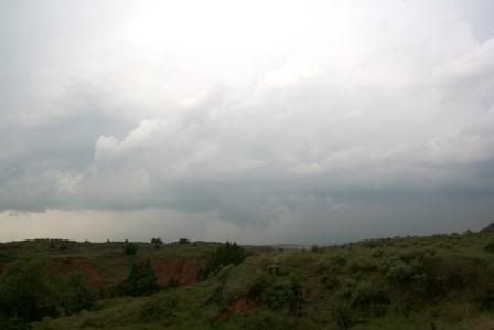
It was apparent that these "storms" weren't cutting it and we decided to go five miles north and 15 miles west to the town of Shattuck, and closer the surface boundary (now a northward-moving warm front). Once in Shattuck we could see a rapidly developing storm to our north. A quick call to our friend Phil Warren, who was nowcasting for us that day, confirmed that this cell was favorably isolated and we took off north on US283 out of town. After about six or seven miles, we stopped briefly to capture the exploding storm (this may be my favorite pic of the day), now located near the Catesby area.

Continuing north, we passed the new SMART-R radar trucks (saw them a few times) stopped along the highway scanning the storm (sweet!). A few miles later we found a nice spot to sit and watch the storm start to crank up and a wall cloud began to form; at this point a severe thunderstorm warning was in effect for Harper County, and we knew it was only a matter of time before it earned a TOR.

Stair-stepping north and east along dirt county roads, we had a hard time seeing the base of the storm from more than a few miles away due to the very thick and soupy haze that draped the whole area. As we approached HWY412/270, a very impressive (but low-contrast at this point) wall cloud had formed and a tornado warning was issued at 428PM, a mere 1/2 hour after the significant weather advisory was issued. Pics from this segment are forthcoming.
After watching a few brief funnels try unsuccessfully, we went five miles east and turned north onto SR46 in the town of May. As we drove north along this road, we had a very impressive wall cloud a couple of miles straight out the windshield. A bit north of the intersection with SR149, we stopped again to grab some pictures.
As the wall cloud was weakening rather rapidly, we could see a new storm (which reminded us both of the 4/24/06 El Reno supercell) get organized less than ten miles to our west. From rising scud, to a classic rain foot, this storm had all of the earmarks of a developing supercell, and within a few minutes a tornado warning was issued. We hopped back in the car and drove another three or four miles north, where the storm that would hold the "best-storm-I've-ever-seen record" for two whole hours, took shape right in front of us. It is worth noting that at the location of the next few pictures, there was walnut-sized hail from the first storm melting on the ground. It wasn't until later that we found out that it was the size of softballs when it had first fallen. Yikes. With a wide-angle lens it appears farther away than the mile and a half or two miles that it actually was; check out that structure!

Wall cloud, zoomed in a bit.

Notably, as this storm was producing that incredible wall cloud, a news chopper from one of the local OKC stations was hovering overhead, which was a cool first for us. In the 'wide-angle' shot above, it is visible only as a black pixel roughly above the "2" in the watermark, but below is a cropped image showing quite clearly what it is.

This storm really tried hard to drop a tornado, but it never quite got there. Oh well.
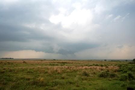
After following this storm northward for another few miles, it weakened dramatically near the KS border. The time was now approximately 6pm, and we decided to head south to gas up in Buffalo. Getting word from our nowcaster that there were tornado-warned storms within-reach in the TX panhandle, we headed in that direction using HWY15. An hour later as we approached the storm intense cloud-to-ground lightning became visible and we turned south from 15 onto paved CR1454 for six miles. Just a quick note to anyone ever chasing in Lipscomb County, TX (far NErn panhandle), please be aware that the paved road network is extremely limited. Had there been any significant precip prior to our arrival we would have had pretty serious problems with the mud. Anyway, we turned onto CR N (thankfully driveably-dry at this point) and headed west to CR 305 where we were met with the most breath-taking storm I've ever seen.
Tornadic HP Supercell north of Lipscomb, TX.


As the sun continued to set the storm gusted out, with temperatures in the frigid outflow a good twenty degrees colder than in the surrounding environment, this storm weakened. A new supercell was taking shape to the southwest, but after an amazing day with three gorgeous, tornado-warned supercells, practically no rain, and no desire to mess with nighttime tornadoes, we decided to call it a day. More photos will likely be added in the next week. Wow this is way longer than I expected to be
Sam


