Olga's next shot: Becoming Better Organized

This is the general tropical discussion area. Anyone can take their shot at predicting a storms path.

Moderator: S2k Moderators

Forum rules

The posts in this forum are NOT official forecasts and should not be used as such. They are just the opinion of the poster and may or may not be backed by sound meteorological data. They are NOT endorsed by any professional institution or STORM2K. For official information, please refer to products from the National Hurricane Center and National Weather Service.

Help Support Storm2K
Message
Author
User avatar
HURAKAN
Professional-Met
Professional-Met
Posts: 46086
Age: 38
Joined: Thu May 20, 2004 4:34 pm
Location: Key West, FL
Contact:

Olga's next shot: Becoming Better Organized

#1 Postby HURAKAN » Sun Nov 04, 2007 6:12 pm

Image

All the images:

Image

Image

Image

Image

Image

Image

Image

GFS 24 hrs:
Image

GFS 48 hrs:
Image

GFS 72 hrs:
Image

GFS 96 hrs:
Image

Windshear:
Image

Windshear tendency:
Image
0 likes   

CrazyC83
Professional-Met
Professional-Met
Posts: 34005
Joined: Tue Mar 07, 2006 11:57 pm
Location: Deep South, for the first time!

#2 Postby CrazyC83 » Sun Nov 04, 2007 6:14 pm

I agree with you in thinking any Olga will come from a previously extratropical system in the subtropical Atlantic - that seems to be the norm at the end of the season.
0 likes   

Cyclone1
Category 5
Category 5
Posts: 2739
Age: 33
Joined: Tue Jun 12, 2007 12:03 pm
Location: Florida

#3 Postby Cyclone1 » Sun Nov 04, 2007 6:26 pm

GAH, Hurakan. You beat me to the thread!

I was going to start a thread on the storm (rare for me to ever start a thread) and you beat me.

Whatever, it's moving Southwest, which means it should lose any fronts it may have soon.
0 likes   

RL3AO
Moderator-Pro Met
Moderator-Pro Met
Posts: 16308
Joined: Thu Jun 14, 2007 10:03 pm
Location: NC

#4 Postby RL3AO » Sun Nov 04, 2007 6:33 pm

I just don't know how many of these high latitude ET transitions you can have in a year.
0 likes   

Matt-hurricanewatcher

Re: Olga's next shot

#5 Postby Matt-hurricanewatcher » Sun Nov 04, 2007 7:37 pm

I give this 60 percent chance of pulling it off. Will our friends pull the switch is the question.
0 likes   

Squarethecircle
Category 5
Category 5
Posts: 2165
Joined: Fri Oct 19, 2007 4:00 pm
Location: Fairfax, VA

Re: Olga's next shot

#6 Postby Squarethecircle » Sun Nov 04, 2007 8:03 pm

Less for me; although these November storms do this quite a bit, and we did have Jerry and 15. The convection, however, is impressively high. Shear is fairly heavy, but most storms forming at these latitudes (and there are quite a few) have to deal with that. And the big question is... Does the NHC care? Like, at all?
0 likes   

User avatar
Typhoon_Willie
Category 5
Category 5
Posts: 1042
Joined: Mon Jun 09, 2003 3:19 pm
Location: Greenacres City, Florida

Re: Olga's next shot

#7 Postby Typhoon_Willie » Sun Nov 04, 2007 10:14 pm

I would think so since shipping interests do listen to the Hurricane Centers forecasts on tropical activity along with the high seas forecast.
0 likes   

User avatar
Evil Jeremy
S2K Supporter
S2K Supporter
Posts: 5463
Age: 32
Joined: Mon Apr 10, 2006 2:10 pm
Location: Los Angeles, CA

Re: Olga's next shot

#8 Postby Evil Jeremy » Mon Nov 05, 2007 7:50 am

about a week ago during Noel, almost every model was showing devlopment in this area, heading south and west for a while before disapating.
0 likes   

Squarethecircle
Category 5
Category 5
Posts: 2165
Joined: Fri Oct 19, 2007 4:00 pm
Location: Fairfax, VA

Re: Olga's next shot

#9 Postby Squarethecircle » Mon Nov 05, 2007 8:42 am

I remember that, but the models didn't seem to suggest a tight enough low to become tropical (or subtropical, for that matter). Anyway, if you look at the most recent satellite pictures, however, it seems that there is some sort of sub-tropical nature to it, though I doubt anything will come of this. The convection is surprising high, though. Reminds me of that other storm we had similar to this one, with convection close to the center, that didn't make it.
0 likes   

User avatar
HURAKAN
Professional-Met
Professional-Met
Posts: 46086
Age: 38
Joined: Thu May 20, 2004 4:34 pm
Location: Key West, FL
Contact:

#10 Postby HURAKAN » Mon Nov 05, 2007 10:34 am

Looks like Olga is not far from present:

Image
0 likes   

User avatar
wxman57
Moderator-Pro Met
Moderator-Pro Met
Posts: 22989
Age: 67
Joined: Sat Jun 21, 2003 8:06 pm
Location: Houston, TX (southwest)

Re: Olga's next shot: System becoming better organized

#11 Postby wxman57 » Mon Nov 05, 2007 10:46 am

Here's a McIdas shot. Not bad looking. NHC won't upgrade/classify it as subtropical unless convection increases more and persists. GFS forecasts a slow southward movement the next 2-3 days down to 30N. NHC appears to be ignoring it for now, indicating they won't consider an upgrade unless it develops an eye in a few days.

Image
0 likes   

User avatar
cycloneye
Admin
Admin
Posts: 145848
Age: 69
Joined: Thu Oct 10, 2002 10:54 am
Location: San Juan, Puerto Rico

Re: Olga's next shot: System becoming better organized

#12 Postby cycloneye » Mon Nov 05, 2007 10:57 am

But NHC is not talking about this yet.

ABNT20 KNHC 051555
TWOAT
TROPICAL WEATHER OUTLOOK
NWS TPC/NATIONAL HURRICANE CENTER MIAMI FL
1130 AM EST MON NOV 5 2007

FOR THE NORTH ATLANTIC...CARIBBEAN SEA AND THE GULF OF MEXICO...

TROPICAL CYCLONE FORMATION IS NOT EXPECTED DURING THE NEXT 48 HOURS.

$$

FORECASTER FRANKLIN
0 likes   

User avatar
HURAKAN
Professional-Met
Professional-Met
Posts: 46086
Age: 38
Joined: Thu May 20, 2004 4:34 pm
Location: Key West, FL
Contact:

#13 Postby HURAKAN » Mon Nov 05, 2007 11:51 am

Image
0 likes   

User avatar
wxman57
Moderator-Pro Met
Moderator-Pro Met
Posts: 22989
Age: 67
Joined: Sat Jun 21, 2003 8:06 pm
Location: Houston, TX (southwest)

Re: Olga's next shot: System becoming better organized

#14 Postby wxman57 » Mon Nov 05, 2007 12:01 pm

Very similar setup to Epsilon (Nov. 28, 2005). Front to west, blocked by high pressure to north. NHC didn't talk much about Epsilon until the convection wrapped all the way around the center forming an eye-like feature. Could happen with this low. The only potential impact will be on our hurricane pool.
0 likes   

User avatar
HURAKAN
Professional-Met
Professional-Met
Posts: 46086
Age: 38
Joined: Thu May 20, 2004 4:34 pm
Location: Key West, FL
Contact:

#15 Postby HURAKAN » Mon Nov 05, 2007 12:10 pm

wxman57, do you think this has a good chance at becoming OLGA?
0 likes   

User avatar
wxman57
Moderator-Pro Met
Moderator-Pro Met
Posts: 22989
Age: 67
Joined: Sat Jun 21, 2003 8:06 pm
Location: Houston, TX (southwest)

Re:

#16 Postby wxman57 » Mon Nov 05, 2007 12:22 pm

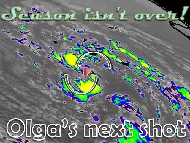
HURAKAN wrote:wxman57, do you think this has a good chance at becoming OLGA?


A better question might be if the NHC will bother with it. Unless the convection wraps all around the center, forming a pseudo-eye, then I doubt the NHC will talk much about it. Chances of that happening may be in the 30-40% range, though. Maybe even a little higher.
0 likes   

Derek Ortt

#17 Postby Derek Ortt » Mon Nov 05, 2007 12:56 pm

they also might initiate advisories on the system if a ship is sunk like they did with the previous Olga
0 likes   

CrazyC83
Professional-Met
Professional-Met
Posts: 34005
Joined: Tue Mar 07, 2006 11:57 pm
Location: Deep South, for the first time!

#18 Postby CrazyC83 » Mon Nov 05, 2007 1:04 pm

The good thing is that only some poor fishies and stray ships will have to worry about this...
0 likes   

User avatar
cycloneye
Admin
Admin
Posts: 145848
Age: 69
Joined: Thu Oct 10, 2002 10:54 am
Location: San Juan, Puerto Rico

Re: Olga's next shot: System becoming better organized

#19 Postby cycloneye » Mon Nov 05, 2007 1:36 pm

Image

Is getting dark in that part of the world,but you can still see in the visble image the impressive circulation.
0 likes   

Squarethecircle
Category 5
Category 5
Posts: 2165
Joined: Fri Oct 19, 2007 4:00 pm
Location: Fairfax, VA

Re: Olga's next shot: System becoming better organized

#20 Postby Squarethecircle » Mon Nov 05, 2007 1:46 pm

This is a lot better looking than it was even this morning. If the NHC notice this, it could be not too far away from an upgrade to STD.
0 likes   


Return to “Talkin' Tropics”

Who is online

Users browsing this forum: jgh and 29 guests