
EPAC: BLANCA - Post-Tropical
Moderator: S2k Moderators
-
Hypercane_Kyle

- Tropical Low

- Posts: 32
- Joined: Sat Mar 07, 2015 7:58 pm
-
TheAustinMan

- Category 1

- Posts: 445
- Joined: Mon Jul 08, 2013 4:26 pm
- Location: Oak Hill/Sunset Valley, TX
- Contact:
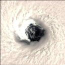
Blanca has continued to strengthen rapidly overnight and doesn't appear to be hitting any intensification hiccups so far. The storm storms expanding in areal coverage and the CDO is mighty impressive (a solid ring of -80C cloud tops!). I think that Blanca at this point is a category 4 hurricane, but that's for the NHC to decide.
Personal Forecast Disclaimer:
The posts in this forum are NOT official forecast and should not be used as such. They are just the opinion of the poster and may or may not be backed by sound meteorological data. They are NOT endorsed by any professional institution or storm2k.org. For official information, please refer to the NHC and NWS products.
-
cycloneye

- Storm2k Moderator

- Posts: 109415
- Joined: Thu Oct 10, 2002 10:54 am
- Location: San Juan, Puerto Rico
Re: EPAC: BLANCA - Hurricane
Oh boy,it would be great if recon goes today but they are not.I don't know why they didn't planned for one knowing it was going to do RI.
Visit the Caribbean-Central America Weather Thread where you can find at first post web cams,radars
and observations from Caribbean basin members Click Here
and observations from Caribbean basin members Click Here
-
tolakram
- Storm2k Moderator
- Posts: 8799
- Joined: Sun Aug 27, 2006 8:23 pm
- Location: Florence, KY (name is Mark)
Re: EPAC: BLANCA - Hurricane
Saved un-enhanced IR loop. Very impressive.

M a r k
- - - - -
The posts in this forum are NOT official forecasts and should not be used as such. Posts are the opinion of the poster and may or may not be backed by sound meteorological data. Posts are NOT endorsed by any professional institution or STORM2K.org. For official information and forecasts, please refer to NHC and NWS products.
-
Yellow Evan

- Category 5

- Posts: 8352
- Joined: Fri Jul 15, 2011 12:48 pm
- Location: S Nevada
----- Current Analysis -----
Date : 03 JUN 2015 Time : 111500 UTC
Lat : 12:25:21 N Lon : 104:38:42 W
CI# /Pressure/ Vmax
5.5 / 960.9mb/102.0kt
Final T# Adj T# Raw T#
5.5 6.1 7.0
Estimated radius of max. wind based on IR :N/A km
Center Temp : -55.1C Cloud Region Temp : -78.0C
Scene Type : EYE
Date : 03 JUN 2015 Time : 111500 UTC
Lat : 12:25:21 N Lon : 104:38:42 W
CI# /Pressure/ Vmax
5.5 / 960.9mb/102.0kt
Final T# Adj T# Raw T#
5.5 6.1 7.0
Estimated radius of max. wind based on IR :N/A km
Center Temp : -55.1C Cloud Region Temp : -78.0C
Scene Type : EYE
The posts in this forum are not official forecasts and should not be used as such. They are solely the opinions of the poster and may or may not be backed by sound meteorological data. For official information, please refer to your local weather service's products.
EPAC spreadsheet, Twitter
EPAC spreadsheet, Twitter
-
Yellow Evan
- Category 5
- Posts: 8352
- Joined: Fri Jul 15, 2011 12:48 pm
- Location: S Nevada
03/1145 UTC 12.5N 104.6W T6.0/6.0 BLANCA -- East Pacific
Expect 115.
Expect 115.
The posts in this forum are not official forecasts and should not be used as such. They are solely the opinions of the poster and may or may not be backed by sound meteorological data. For official information, please refer to your local weather service's products.
EPAC spreadsheet, Twitter
EPAC spreadsheet, Twitter
-
SouthDadeFish

- Professional-Met

- Posts: 2099
- Joined: Thu Sep 23, 2010 2:54 pm
- Location: Miami, FL /Albany, NY
As Blanca gets stronger, but remains stationary, one has to wonder if upwelling may lead to a limit on intensification. Perhaps I'm reading too much into this, but cloud tops are already beginning to warm. Don't get me wrong, this will still be a very powerful hurricane, but any potential upwelling may limit Cat 5/140 kt+.
-
Yellow Evan
- Category 5
- Posts: 8352
- Joined: Fri Jul 15, 2011 12:48 pm
- Location: S Nevada
Re:
SouthDadeFish wrote:As Blanca gets stronger, but remains stationary, one has to wonder if upwelling may lead to a limit on intensification. Perhaps I'm reading too much into this, but cloud tops are already beginning to warm. Don't get me wrong, this will still be a very powerful hurricane, but any potential upwelling may limit Cat 5/140 kt+.
OHC is high and SSTS are around 31C. Shouldn't be too much of an issue.
The posts in this forum are not official forecasts and should not be used as such. They are solely the opinions of the poster and may or may not be backed by sound meteorological data. For official information, please refer to your local weather service's products.
EPAC spreadsheet, Twitter
EPAC spreadsheet, Twitter
-
Yellow Evan
- Category 5
- Posts: 8352
- Joined: Fri Jul 15, 2011 12:48 pm
- Location: S Nevada
EP, 02, 2015060312, , BEST, 0, 125N, 1047W, 115, 948, HU, 34, NEQ, 30, 30, 30, 30, 1008, 150, 15, 105, 0, E, 0, , 0, 0, BLANCA, D, 12, NEQ, 120, 120, 120, 90,
EP, 02, 2015060312, , BEST, 0, 125N, 1047W, 115, 948, HU, 34, NEQ, 80, 80, 70, 80, 1008, 150, 15, 0, 0, E, 0, , 0, 0, BLANCA, D, 0, , 0, 0, 0, 0,
EP, 02, 2015060312, , BEST, 0, 125N, 1047W, 115, 948, HU, 50, NEQ, 30, 30, 30, 30, 1008, 150, 15, 0, 0, E, 0, , 0, 0, BLANCA,
115.
EP, 02, 2015060312, , BEST, 0, 125N, 1047W, 115, 948, HU, 34, NEQ, 80, 80, 70, 80, 1008, 150, 15, 0, 0, E, 0, , 0, 0, BLANCA, D, 0, , 0, 0, 0, 0,
EP, 02, 2015060312, , BEST, 0, 125N, 1047W, 115, 948, HU, 50, NEQ, 30, 30, 30, 30, 1008, 150, 15, 0, 0, E, 0, , 0, 0, BLANCA,
115.
The posts in this forum are not official forecasts and should not be used as such. They are solely the opinions of the poster and may or may not be backed by sound meteorological data. For official information, please refer to your local weather service's products.
EPAC spreadsheet, Twitter
EPAC spreadsheet, Twitter
-
SouthDadeFish
- Professional-Met
- Posts: 2099
- Joined: Thu Sep 23, 2010 2:54 pm
- Location: Miami, FL /Albany, NY
Re: Re:
Yellow Evan wrote:SouthDadeFish wrote:As Blanca gets stronger, but remains stationary, one has to wonder if upwelling may lead to a limit on intensification. Perhaps I'm reading too much into this, but cloud tops are already beginning to warm. Don't get me wrong, this will still be a very powerful hurricane, but any potential upwelling may limit Cat 5/140 kt+.
OHC is high and SSTS are around 31C. Shouldn't be too much of an issue.
SSTs are not too valuable when dealing with major hurricanes as a great deal of mixing is occurring. And I'm aware that there is a deep layer of warm water, I'm just questioning if it is deep enough. My guess is that Blanca gets moving just in time before upwelling starts to become an issue. The 26 C isotherm appears to be ~100 m, which is likely sufficient for intensification over the next day:

I was simply playing devil's advocate. For now, we get to watch quite a show.
-
Yellow Evan
- Category 5
- Posts: 8352
- Joined: Fri Jul 15, 2011 12:48 pm
- Location: S Nevada
Re: Re:
SouthDadeFish wrote:Yellow Evan wrote:SouthDadeFish wrote:As Blanca gets stronger, but remains stationary, one has to wonder if upwelling may lead to a limit on intensification. Perhaps I'm reading too much into this, but cloud tops are already beginning to warm. Don't get me wrong, this will still be a very powerful hurricane, but any potential upwelling may limit Cat 5/140 kt+.
OHC is high and SSTS are around 31C. Shouldn't be too much of an issue.
SSTs are not too valuable when dealing with major hurricanes as a great deal of mixing is occurring. And I'm aware that there is a deep layer of warm water, I'm just questioning if it is deep enough. My guess is that Blanca gets moving just in time before upwelling starts to become an issue. The 26 C isotherm appears to be ~100 m, which is likely sufficient for intensification over the next day:
I was simply playing devil's advocate. For now, we get to watch quite a show.
By that time, it's expected to start moving out of the area it is in.
The posts in this forum are not official forecasts and should not be used as such. They are solely the opinions of the poster and may or may not be backed by sound meteorological data. For official information, please refer to your local weather service's products.
EPAC spreadsheet, Twitter
EPAC spreadsheet, Twitter
-
SouthDadeFish
- Professional-Met
- Posts: 2099
- Joined: Thu Sep 23, 2010 2:54 pm
- Location: Miami, FL /Albany, NY

-
Yellow Evan
- Category 5
- Posts: 8352
- Joined: Fri Jul 15, 2011 12:48 pm
- Location: S Nevada
Probs nearing 120 knots.
----- Current Analysis -----
Date : 03 JUN 2015 Time : 121500 UTC
Lat : 12:24:28 N Lon : 104:38:36 W
CI# /Pressure/ Vmax
6.1 / 948.0mb/117.4kt
Final T# Adj T# Raw T#
6.1 6.1 6.9
Estimated radius of max. wind based on IR :N/A km
Center Temp : -42.5C Cloud Region Temp : -76.7C
Scene Type : EYE
----- Current Analysis -----
Date : 03 JUN 2015 Time : 121500 UTC
Lat : 12:24:28 N Lon : 104:38:36 W
CI# /Pressure/ Vmax
6.1 / 948.0mb/117.4kt
Final T# Adj T# Raw T#
6.1 6.1 6.9
Estimated radius of max. wind based on IR :N/A km
Center Temp : -42.5C Cloud Region Temp : -76.7C
Scene Type : EYE
The posts in this forum are not official forecasts and should not be used as such. They are solely the opinions of the poster and may or may not be backed by sound meteorological data. For official information, please refer to your local weather service's products.
EPAC spreadsheet, Twitter
EPAC spreadsheet, Twitter
-
Krit-tonkla

- Tropical Storm

- Posts: 137
- Joined: Tue Aug 12, 2014 7:28 am
SHIPS run has this peaking at 151 knots.
* EAST PACIFIC SHIPS INTENSITY FORECAST *
* IR SAT DATA AVAILABLE, OHC AVAILABLE *
* BLANCA EP022015 06/03/15 12 UTC *
TIME (HR) 0 6 12 18 24 36 48 60 72 84 96 108 120
V (KT) NO LAND 115 129 139 146 151 148 138 121 103 83 62 39 19
V (KT) LAND 115 129 139 146 151 148 138 121 103 83 62 39 31
V (KT) LGE mod 115 129 135 138 139 140 137 123 102 81 63 48 36
Storm Type TROP TROP TROP TROP TROP TROP TROP TROP TROP TROP TROP TROP TROP
SHEAR (KT) 1 4 5 2 5 6 11 11 11 13 18 17 15
SHEAR ADJ (KT) -4 -5 -3 -4 -1 10 9 7 7 9 0 9 6
SHEAR DIR 270 194 170 111 81 98 139 112 135 125 132 163 200
SST (C) 30.3 30.3 30.3 30.3 30.2 30.1 29.5 28.5 27.3 26.0 24.7 23.8 23.3
POT. INT. (KT) 163 163 164 165 165 166 160 149 136 123 109 99 94
200 MB T (C) -52.2 -51.7 -51.3 -51.7 -51.5 -50.6 -50.9 -50.6 -51.2 -50.4 -51.0 -50.9 -51.1
TH_E DEV (C) 7 7 8 8 8 9 7 7 6 7 4 4 2
700-500 MB RH 83 81 79 77 75 71 68 64 61 57 56 55 53
MODEL VTX (KT) 29 31 34 34 37 38 40 39 37 32 27 19 13
850 MB ENV VOR 41 54 63 70 71 100 98 91 61 54 47 62 44
200 MB DIV 153 159 131 102 107 109 77 56 3 6 -39 -36 -10
700-850 TADV 0 0 0 -1 -2 0 0 0 2 -3 -4 -2 0
LAND (KM) 644 635 626 601 577 522 434 398 388 291 100 5 -14
LAT (DEG N) 12.5 12.6 12.7 13.0 13.3 14.3 16.0 17.5 18.8 20.3 22.0 23.4 24.6
LONG(DEG W) 104.7 104.8 104.8 105.0 105.1 105.9 107.1 108.2 109.0 109.6 110.0 110.4 111.0
STM SPEED (KT) 0 1 2 3 5 9 10 8 8 8 8 7 7
HEAT CONTENT 99 98 97 95 93 79 36 8 4 0 0 0 0
FORECAST TRACK FROM OFCI INITIAL HEADING/SPEED (DEG/KT):205/ 1 CX,CY: 0/ 0
T-12 MAX WIND: 75 PRESSURE OF STEERING LEVEL (MB): 563 (MEAN=581)
GOES IR BRIGHTNESS TEMP. STD DEV. 50-200 KM RAD: 3.9 (MEAN=14.5)
% GOES IR PIXELS WITH T < -20 C 50-200 KM RAD: 100.0 (MEAN=65.0)
INDIVIDUAL CONTRIBUTIONS TO INTENSITY CHANGE
6 12 18 24 36 48 60 72 84 96 108 120
----------------------------------------------------------
SAMPLE MEAN CHANGE 0. 0. 0. 1. 1. 1. 0. 0. -1. -1. -2. -2.
SST POTENTIAL -1. -1. -1. -1. -5. -11. -18. -25. -33. -41. -47. -52.
VERTICAL SHEAR MAG 0. 1. 2. 2. 3. 4. 4. 5. 6. 4. 2. 0.
VERTICAL SHEAR ADJ 0. 1. 1. 1. 0. -1. -1. -1. -2. -2. -3. -4.
VERTICAL SHEAR DIR -1. -1. -1. -1. 1. 1. 1. 1. 1. 0. -1. -1.
PERSISTENCE 11. 16. 17. 15. 8. 3. 0. -2. -2. -2. -2. -3.
200/250 MB TEMP. 0. -1. -2. -3. -5. -7. -9. -11. -13. -13. -14. -14.
THETA_E EXCESS 0. 0. 0. 0. 0. -1. -1. -2. -2. -3. -4. -5.
700-500 MB RH 0. 1. 1. 1. 2. 3. 3. 3. 3. 3. 3. 3.
MODEL VTX TENDENCY 0. 3. 4. 9. 12. 16. 14. 11. 4. -3. -13. -21.
850 MB ENV VORTICITY 0. 0. 0. 0. 1. 2. 3. 3. 4. 5. 5. 6.
200 MB DIVERGENCE 1. 2. 3. 3. 4. 4. 3. 2. 1. 0. -1. -1.
850-700 T ADVEC 0. 0. 0. 0. 0. 0. 0. 0. 0. 0. 0. 0.
ZONAL STORM MOTION 0. -1. -1. -2. -3. -4. -5. -5. -5. -5. -4. -4.
STEERING LEVEL PRES 0. 0. 0. 0. 0. 0. 0. 0. 0. 0. 0. 0.
DAYS FROM CLIM. PEAK 0. 0. 0. 0. 0. 0. 0. -1. -1. -1. -1. -1.
GOES PREDICTORS 2. 3. 4. 4. 5. 5. 5. 4. 4. 3. 3. 3.
OCEAN HEAT CONTENT 1. 2. 4. 6. 8. 9. 7. 5. 4. 4. 3. 1.
----------------------------------------------------------
TOTAL CHANGE 14. 24. 31. 36. 33. 23. 6. -12. -32. -53. -76. -96.
** 2013 E. Pacific RI INDEX EP022015 BLANCA 06/03/15 12 UTC **
( 30 KT OR MORE MAX WIND INCREASE IN NEXT 24 HR)
12 HR PERSISTENCE (KT): 40.0 Range:-22.0 to 38.5 Scaled/Wgted Val: 1.0/ 2.2
850-200 MB SHEAR (KT) : 3.4 Range: 18.7 to 1.4 Scaled/Wgted Val: 0.9/ 1.3
POT = MPI-VMAX (KT) : 49.1 Range: 40.3 to 141.7 Scaled/Wgted Val: 0.1/ 0.1
STD DEV OF IR BR TEMP : 3.9 Range: 38.9 to 2.4 Scaled/Wgted Val: 1.0/ 1.0
Heat content (KJ/cm2) : 96.4 Range: 3.6 to 75.9 Scaled/Wgted Val: 1.0/ 0.9
D200 (10**7s-1) : 130.4 Range:-11.0 to 135.3 Scaled/Wgted Val: 1.0/ 0.7
% area w/pixels <-30 C: 100.0 Range: 41.4 to 100.0 Scaled/Wgted Val: 1.0/ 0.5
850-700 MB REL HUM (%): 75.2 Range: 57.6 to 96.8 Scaled/Wgted Val: 0.4/ -0.1
Prob of RI for 25 kt RI threshold= 95% is 7.6 times the sample mean(13.1%)
Prob of RI for 30 kt RI threshold= 95% is 11.5 times the sample mean( 8.7%)
Prob of RI for 35 kt RI threshold= 95% is 16.7 times the sample mean( 6.0%)
Prob of RI for 40 kt RI threshold= 95% is 23.3 times the sample mean( 4.3%)
## ANNULAR HURRICANE INDEX (AHI) EP022015 BLANCA 06/03/15 12 UTC ##
## STORM NOT ANNULAR, SCREENING STEP FAILED, NPASS=3 NFAIL=4 ##
## AHI= 0 (AHI OF 100 IS BEST FIT TO ANN. STRUC., 1 IS MARGINAL, 0 IS NOT ANNULAR) ##
DISCLAIMER: I am not a meteorologist. Any posts I made, unless copied from some official agency, are only my opinion and is unofficial and often exaggerated. Please refer to your official RSMC for official products and warnings.
Re: EPAC: BLANCA - Hurricane
Its already doing that typical "cloud tops warm around the center as the eye clears out" routine. It started as a (close to) pinhole, lets see where the eye size ends up. It did the steady clearing rate, pretty much as thought.
Hasn't anyone else noticed this blatant pattern of the CDO around the eye warming as the eye clears out? I see it almost every time in RI/EI except for the most insane tropical cyclone deepening and the ones that bottom out at record intensity. So about 90% of the time.
SouthDadeFish wrote:Perhaps I'm reading too much into this, but cloud tops are already beginning to warm.
Hasn't anyone else noticed this blatant pattern of the CDO around the eye warming as the eye clears out? I see it almost every time in RI/EI except for the most insane tropical cyclone deepening and the ones that bottom out at record intensity. So about 90% of the time.
-
Yellow Evan
- Category 5
- Posts: 8352
- Joined: Fri Jul 15, 2011 12:48 pm
- Location: S Nevada
Re:
Krit-tonkla wrote:SHIPS run has this peaking at 151 knots.
* EAST PACIFIC SHIPS INTENSITY FORECAST *
* IR SAT DATA AVAILABLE, OHC AVAILABLE *
* BLANCA EP022015 06/03/15 12 UTC *
TIME (HR) 0 6 12 18 24 36 48 60 72 84 96 108 120
V (KT) NO LAND 115 129 139 146 151 148 138 121 103 83 62 39 19
V (KT) LAND 115 129 139 146 151 148 138 121 103 83 62 39 31
V (KT) LGE mod 115 129 135 138 139 140 137 123 102 81 63 48 36
Storm Type TROP TROP TROP TROP TROP TROP TROP TROP TROP TROP TROP TROP TROP
SHEAR (KT) 1 4 5 2 5 6 11 11 11 13 18 17 15
SHEAR ADJ (KT) -4 -5 -3 -4 -1 10 9 7 7 9 0 9 6
SHEAR DIR 270 194 170 111 81 98 139 112 135 125 132 163 200
SST (C) 30.3 30.3 30.3 30.3 30.2 30.1 29.5 28.5 27.3 26.0 24.7 23.8 23.3
POT. INT. (KT) 163 163 164 165 165 166 160 149 136 123 109 99 94
200 MB T (C) -52.2 -51.7 -51.3 -51.7 -51.5 -50.6 -50.9 -50.6 -51.2 -50.4 -51.0 -50.9 -51.1
TH_E DEV (C) 7 7 8 8 8 9 7 7 6 7 4 4 2
700-500 MB RH 83 81 79 77 75 71 68 64 61 57 56 55 53
MODEL VTX (KT) 29 31 34 34 37 38 40 39 37 32 27 19 13
850 MB ENV VOR 41 54 63 70 71 100 98 91 61 54 47 62 44
200 MB DIV 153 159 131 102 107 109 77 56 3 6 -39 -36 -10
700-850 TADV 0 0 0 -1 -2 0 0 0 2 -3 -4 -2 0
LAND (KM) 644 635 626 601 577 522 434 398 388 291 100 5 -14
LAT (DEG N) 12.5 12.6 12.7 13.0 13.3 14.3 16.0 17.5 18.8 20.3 22.0 23.4 24.6
LONG(DEG W) 104.7 104.8 104.8 105.0 105.1 105.9 107.1 108.2 109.0 109.6 110.0 110.4 111.0
STM SPEED (KT) 0 1 2 3 5 9 10 8 8 8 8 7 7
HEAT CONTENT 99 98 97 95 93 79 36 8 4 0 0 0 0
FORECAST TRACK FROM OFCI INITIAL HEADING/SPEED (DEG/KT):205/ 1 CX,CY: 0/ 0
T-12 MAX WIND: 75 PRESSURE OF STEERING LEVEL (MB): 563 (MEAN=581)
GOES IR BRIGHTNESS TEMP. STD DEV. 50-200 KM RAD: 3.9 (MEAN=14.5)
% GOES IR PIXELS WITH T < -20 C 50-200 KM RAD: 100.0 (MEAN=65.0)
INDIVIDUAL CONTRIBUTIONS TO INTENSITY CHANGE
6 12 18 24 36 48 60 72 84 96 108 120
----------------------------------------------------------
SAMPLE MEAN CHANGE 0. 0. 0. 1. 1. 1. 0. 0. -1. -1. -2. -2.
SST POTENTIAL -1. -1. -1. -1. -5. -11. -18. -25. -33. -41. -47. -52.
VERTICAL SHEAR MAG 0. 1. 2. 2. 3. 4. 4. 5. 6. 4. 2. 0.
VERTICAL SHEAR ADJ 0. 1. 1. 1. 0. -1. -1. -1. -2. -2. -3. -4.
VERTICAL SHEAR DIR -1. -1. -1. -1. 1. 1. 1. 1. 1. 0. -1. -1.
PERSISTENCE 11. 16. 17. 15. 8. 3. 0. -2. -2. -2. -2. -3.
200/250 MB TEMP. 0. -1. -2. -3. -5. -7. -9. -11. -13. -13. -14. -14.
THETA_E EXCESS 0. 0. 0. 0. 0. -1. -1. -2. -2. -3. -4. -5.
700-500 MB RH 0. 1. 1. 1. 2. 3. 3. 3. 3. 3. 3. 3.
MODEL VTX TENDENCY 0. 3. 4. 9. 12. 16. 14. 11. 4. -3. -13. -21.
850 MB ENV VORTICITY 0. 0. 0. 0. 1. 2. 3. 3. 4. 5. 5. 6.
200 MB DIVERGENCE 1. 2. 3. 3. 4. 4. 3. 2. 1. 0. -1. -1.
850-700 T ADVEC 0. 0. 0. 0. 0. 0. 0. 0. 0. 0. 0. 0.
ZONAL STORM MOTION 0. -1. -1. -2. -3. -4. -5. -5. -5. -5. -4. -4.
STEERING LEVEL PRES 0. 0. 0. 0. 0. 0. 0. 0. 0. 0. 0. 0.
DAYS FROM CLIM. PEAK 0. 0. 0. 0. 0. 0. 0. -1. -1. -1. -1. -1.
GOES PREDICTORS 2. 3. 4. 4. 5. 5. 5. 4. 4. 3. 3. 3.
OCEAN HEAT CONTENT 1. 2. 4. 6. 8. 9. 7. 5. 4. 4. 3. 1.
----------------------------------------------------------
TOTAL CHANGE 14. 24. 31. 36. 33. 23. 6. -12. -32. -53. -76. -96.
** 2013 E. Pacific RI INDEX EP022015 BLANCA 06/03/15 12 UTC **
( 30 KT OR MORE MAX WIND INCREASE IN NEXT 24 HR)
12 HR PERSISTENCE (KT): 40.0 Range:-22.0 to 38.5 Scaled/Wgted Val: 1.0/ 2.2
850-200 MB SHEAR (KT) : 3.4 Range: 18.7 to 1.4 Scaled/Wgted Val: 0.9/ 1.3
POT = MPI-VMAX (KT) : 49.1 Range: 40.3 to 141.7 Scaled/Wgted Val: 0.1/ 0.1
STD DEV OF IR BR TEMP : 3.9 Range: 38.9 to 2.4 Scaled/Wgted Val: 1.0/ 1.0
Heat content (KJ/cm2) : 96.4 Range: 3.6 to 75.9 Scaled/Wgted Val: 1.0/ 0.9
D200 (10**7s-1) : 130.4 Range:-11.0 to 135.3 Scaled/Wgted Val: 1.0/ 0.7
% area w/pixels <-30 C: 100.0 Range: 41.4 to 100.0 Scaled/Wgted Val: 1.0/ 0.5
850-700 MB REL HUM (%): 75.2 Range: 57.6 to 96.8 Scaled/Wgted Val: 0.4/ -0.1
Prob of RI for 25 kt RI threshold= 95% is 7.6 times the sample mean(13.1%)
Prob of RI for 30 kt RI threshold= 95% is 11.5 times the sample mean( 8.7%)
Prob of RI for 35 kt RI threshold= 95% is 16.7 times the sample mean( 6.0%)
Prob of RI for 40 kt RI threshold= 95% is 23.3 times the sample mean( 4.3%)
## ANNULAR HURRICANE INDEX (AHI) EP022015 BLANCA 06/03/15 12 UTC ##
## STORM NOT ANNULAR, SCREENING STEP FAILED, NPASS=3 NFAIL=4 ##
## AHI= 0 (AHI OF 100 IS BEST FIT TO ANN. STRUC., 1 IS MARGINAL, 0 IS NOT ANNULAR) ##
I won't be surprised if it ended up reaching 151.
SHIPS RI still maxed out. 95% chance of 155 knots. Wow.
The posts in this forum are not official forecasts and should not be used as such. They are solely the opinions of the poster and may or may not be backed by sound meteorological data. For official information, please refer to your local weather service's products.
EPAC spreadsheet, Twitter
EPAC spreadsheet, Twitter
-
Yellow Evan
- Category 5
- Posts: 8352
- Joined: Fri Jul 15, 2011 12:48 pm
- Location: S Nevada
Also another question is when the NHC forecast 140 for this storm?
The posts in this forum are not official forecasts and should not be used as such. They are solely the opinions of the poster and may or may not be backed by sound meteorological data. For official information, please refer to your local weather service's products.
EPAC spreadsheet, Twitter
EPAC spreadsheet, Twitter
-
cycloneye
- Storm2k Moderator
- Posts: 109415
- Joined: Thu Oct 10, 2002 10:54 am
- Location: San Juan, Puerto Rico
Re: EPAC: BLANCA - Hurricane
Recon will go!!! but not today or on Thursday.  It would be great to have it go today but that is what it is.
PACIFIC REQUIREMENTS
1. NEGATIVE RECONNAISSANCE REQUIREMENTS.
2. OUTLOOK FOR SUCCEEDING DAY: FIX HURRICANE BLANCA
AT 05/1800Z NEAR 16.5N 112.8W
3. ADDITIONAL DAY OUTLOOK: WE ANTICIPATE TASKING FOR
06/18OOZ AND 07/1800Z.
PACIFIC REQUIREMENTS
1. NEGATIVE RECONNAISSANCE REQUIREMENTS.
2. OUTLOOK FOR SUCCEEDING DAY: FIX HURRICANE BLANCA
AT 05/1800Z NEAR 16.5N 112.8W
3. ADDITIONAL DAY OUTLOOK: WE ANTICIPATE TASKING FOR
06/18OOZ AND 07/1800Z.
Visit the Caribbean-Central America Weather Thread where you can find at first post web cams,radars
and observations from Caribbean basin members Click Here
and observations from Caribbean basin members Click Here
-
cycloneye
- Storm2k Moderator
- Posts: 109415
- Joined: Thu Oct 10, 2002 10:54 am
- Location: San Juan, Puerto Rico
Re: EPAC: BLANCA - Hurricane
HURRICANE BLANCA DISCUSSION NUMBER 12
NWS NATIONAL HURRICANE CENTER MIAMI FL EP022015
1000 AM CDT WED JUN 03 2015
Blanca has rapidly intensified since yesterday and the initial
intensity has been set at 115 kt. This is an increase in
the winds of 60 kt since yesterday at 1200 UTC. The initial
intensity is based on objective and subjective T-numbers which have
reached T6.0 on the Dvorak scale. The hurricane has developed a
distinct pinhole eye in both IR and visible images surrounded by
very deep convection. There is an opportunity for Blanca to
intensify further since the hurricane is located within an ideal
environment of low shear and high ocean heat content as indicated by
statistical-dynamical models. In addition, the Rapid Intensification
Index remains extremely high, and this has been the case during the
past 24 to 36 hours. Beyond 48 hours, the hurricane will encounter
lower SSTs and a gradual weakening should begin.
Blanca is currently trapped within weak steering currents and the
cyclone has barely moved since yesterday and little motion is
anticipated today. During the next 24 hours, the hurricane should
begin a northwestward track with some increase in forward speed as a
high pressure system amplifies over the southwestern Unites States
and Mexico, and a mid-level trough approaches from the northwest.
The NHC forecast is very similar to the previous one and follows
very closely the consensus of the GFS and the ECMWF models.
Since Blanca is a potential threat to Baja California in a few
days, a reconnaissance aircraft will likely investigate the
cyclone on Friday.
Blanca is the earliest second major hurricane to form in the
eastern North Pacific since reliable records began in 1971.
FORECAST POSITIONS AND MAX WINDS
INIT 03/1500Z 12.4N 104.7W 115 KT 130 MPH
12H 04/0000Z 12.5N 104.7W 125 KT 145 MPH
24H 04/1200Z 13.1N 105.0W 140 KT 160 MPH
36H 05/0000Z 14.2N 105.9W 135 KT 155 MPH
48H 05/1200Z 15.7N 107.1W 130 KT 150 MPH
72H 06/1200Z 18.8N 109.2W 110 KT 125 MPH
96H 07/1200Z 21.5N 110.2W 75 KT 85 MPH
120H 08/1200Z 24.3N 111.2W 45 KT 50 MPH...INLAND
$$
Forecaster Avila
Visit the Caribbean-Central America Weather Thread where you can find at first post web cams,radars
and observations from Caribbean basin members Click Here
and observations from Caribbean basin members Click Here

Re: EPAC: BLANCA - Hurricane
cycloneye wrote:Recon will go!!! but not today or on Thursday.
PACIFIC REQUIREMENTS
1. NEGATIVE RECONNAISSANCE REQUIREMENTS.
2. OUTLOOK FOR SUCCEEDING DAY: FIX HURRICANE BLANCA
AT 05/1800Z NEAR 16.5N 112.8W
3. ADDITIONAL DAY OUTLOOK: WE ANTICIPATE TASKING FOR
06/18OOZ AND 07/1800Z.
That's unfortunate, I have little doubt we would've seen much lower pressures than what it is showing had recon gone today and tomorrow.
The above post and any post by Ntxw is NOT an official forecast and should not be used as such. It is just the opinion of the poster and may or may not be backed by sound meteorological data. It is NOT endorsed by any professional institution including storm2k.org. For official information, please refer to NWS products.
Who is online
Users browsing this forum: No registered users and 23 guests