Hmm.. SREF now for the first time showing snow for DFW. With ensembles showing up to 4 inches for mineral wells and an average 1" for DFW, with some ensembles showing up to 3". Is it gonna happen? Probably not. Trend is your friend though. Looks like your Classic rain- to snow event.
I feel like what could happen is the snow aloft is going to cool/moisten the column and lower temps(which we've all seen before), but how low, how fast? Tricky one for sure.
Even if we get rapid cooling before the event ends though, the sfc temps never look close to supporting significant accumulations.
Texas Winter 2014-2015
Moderator: S2k Moderators
Forum rules
 The posts in this forum are NOT official forecast and should not be used as such. They are just the opinion of the poster and may or may not be backed by sound meteorological data. They are NOT endorsed by any professional institution or STORM2K.

The posts in this forum are NOT official forecast and should not be used as such. They are just the opinion of the poster and may or may not be backed by sound meteorological data. They are NOT endorsed by any professional institution or STORM2K.
-
SouthernMet

- Category 3

- Posts: 857
- Joined: Sun Aug 29, 2010 8:23 pm
- Location: fort worth, tx
Re: Texas Winter 2014-2015
Last edited by SouthernMet on Mon Dec 22, 2014 10:13 am, edited 1 time in total.
0 likes
Nothing that SouthernMet posts, is an official forecast,nor does it reflect views of STORM2K.. SouthernMet is just adding to the great discussions on STORM2K.. Refer to NWS for official forecasts.
-
TeamPlayersBlue

- Category 5

- Posts: 3530
- Joined: Tue Feb 02, 2010 1:44 am
- Location: Denver/Applewood, CO
Def likes to play games with us, it happens everytime. (Vanishes about 8 days out.) Whats the key here so i can still be confident that cold is coming? The fact that there is blocking in the high latitudes at all? It still shows blocking except it brings the air over the Pacific.
0 likes
Personal Forecast Disclaimer:
The posts in this forum are NOT official forecast and should not be used as such. They are just the opinion of the poster and may or may not be backed by sound meteorological data. They are NOT endorsed by any professional institution or storm2k.org. For official information, please refer to the NHC and NWS products.
The posts in this forum are NOT official forecast and should not be used as such. They are just the opinion of the poster and may or may not be backed by sound meteorological data. They are NOT endorsed by any professional institution or storm2k.org. For official information, please refer to the NHC and NWS products.
-
GRAYSONCO.WX
- Category 1

- Posts: 450
- Joined: Thu Jan 06, 2011 4:29 pm
- Location: Denison, Texas
Re: Texas Winter 2014-2015
Not saying it will happen, but the 12Z NAM (on WeatherBELL) is showing rain/snow mix for north Texas with highest "accumulations" east of I-35 for northeastern Texas.
0 likes
-
Ralph's Weather
- S2K Supporter

- Posts: 3371
- Age: 38
- Joined: Fri Dec 13, 2013 11:55 am
- Location: Lindale, TX
- Contact:
Re: Texas Winter 2014-2015
SouthernMet wrote:Hmm.. SREF now for the first time showing snow for DFW. With ensembles showing up to 4 inches for mineral wells and an average 1" for DFW, with some ensembles showing up to 3". Is it gonna happen? Probably not. Trend is your friend though. Looks like your Classic rain- to snow event.
I feel like what could happen is the snow aloft is going to cool/moisten the column and lower temps(which we've all seen before), but how low, how fast? Tricky one for sure.
That SREF run sure is interesting, there could sure be a lot of very surprised people tomorrow. It is even showing 10+% chance for a foot SE of Wichita Falls and a widespread area of 1" chances west of I-35 where on the previous run it showed only a small chance in West Texas. If this trend continues it will get real interesting. It all hinges on how much warm, dry air is near the surface because it will definitely be falling at 5,000 feet.
0 likes
Follow on Facebook at Ralph's Weather.
-
gatorcane

- S2K Supporter
- Posts: 23708
- Age: 48
- Joined: Sun Mar 13, 2005 3:54 pm
- Location: Boca Raton, FL
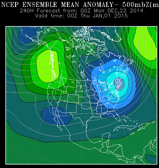
Look like the globals have backed off some on the severity of the cold for Texas, but there still looks to be cold on the way. One round comes in around 48-72 hours around Christmas with the JMA and GEM, and even the ECMWF to a lesser extent quite bullish on the cold. Then the other round comes in towards the end of the month. GEM and JMA very bullish, and GFS and ECMWF ensembles still showing colder anomalies. The end-of-the-month cold is still out a ways, and will need to get closer to that timeframe to see where the Arctic air ends up going and how cold it is. There are some indications from the globals the end-of-month artic air nose-dives south down the eastern spine of the Rockies and will need to watch for this possibility in future model runs.
Last edited by gatorcane on Mon Dec 22, 2014 10:33 am, edited 1 time in total.
0 likes
-
wxman57

- Moderator-Pro Met

- Posts: 23174
- Age: 68
- Joined: Sat Jun 21, 2003 8:06 pm
- Location: Houston, TX (southwest)
Re:
TeamPlayersBlue wrote:So nat gas futures are down almost 8% today, i think alot of people saw the models drop the cold air yesterday, i hope that the models catch onto them again
It appears that my plan to block all Arctic air intrusions is working! Now, if I can just keep the Canadian air out of here...
0 likes
-
SouthernMet
- Category 3
- Posts: 857
- Joined: Sun Aug 29, 2010 8:23 pm
- Location: fort worth, tx
Re: Texas Winter 2014-2015
Ralph's Weather wrote:SouthernMet wrote:Hmm.. SREF now for the first time showing snow for DFW. With ensembles showing up to 4 inches for mineral wells and an average 1" for DFW, with some ensembles showing up to 3". Is it gonna happen? Probably not. Trend is your friend though. Looks like your Classic rain- to snow event.
I feel like what could happen is the snow aloft is going to cool/moisten the column and lower temps(which we've all seen before), but how low, how fast? Tricky one for sure.
That SREF run sure is interesting, there could sure be a lot of very surprised people tomorrow. It is even showing 10+% chance for a foot SE of Wichita Falls and a widespread area of 1" chances west of I-35 where on the previous run it showed only a small chance in West Texas. If this trend continues it will get real interesting. It all hinges on how much warm, dry air is near the surface because it will definitely be falling at 5,000 feet.
Check out the sref plume for Graham, that's insanity. http://www.spc.noaa.gov/exper/sref/fplu ... YP=roadmap
0 likes
Nothing that SouthernMet posts, is an official forecast,nor does it reflect views of STORM2K.. SouthernMet is just adding to the great discussions on STORM2K.. Refer to NWS for official forecasts.
-
SouthernMet
- Category 3
- Posts: 857
- Joined: Sun Aug 29, 2010 8:23 pm
- Location: fort worth, tx
Re: Texas Winter 2014-2015
One of these models is going to bust big time lol.
0 likes
Nothing that SouthernMet posts, is an official forecast,nor does it reflect views of STORM2K.. SouthernMet is just adding to the great discussions on STORM2K.. Refer to NWS for official forecasts.
-
SouthernMet
- Category 3
- Posts: 857
- Joined: Sun Aug 29, 2010 8:23 pm
- Location: fort worth, tx
Re: Texas Winter 2014-2015
looks like the 12z gfs is coming to it's senses..
spoke too soon.
it does move the system in a little faster, which is not good if you want snow.
spoke too soon.
it does move the system in a little faster, which is not good if you want snow.
Last edited by SouthernMet on Mon Dec 22, 2014 11:08 am, edited 1 time in total.
0 likes
Nothing that SouthernMet posts, is an official forecast,nor does it reflect views of STORM2K.. SouthernMet is just adding to the great discussions on STORM2K.. Refer to NWS for official forecasts.
-
GRAYSONCO.WX
- Category 1
- Posts: 450
- Joined: Thu Jan 06, 2011 4:29 pm
- Location: Denison, Texas
Re: Texas Winter 2014-2015
SouthernMet wrote:looks like the 12z gfs is coming to it's senses..
spoke too soon.
Yeah, it's showing 1-2" just west of the Metro, maybe 1" for Metro, and 2-4" in northeast Texas.
0 likes
-
GRAYSONCO.WX
- Category 1
- Posts: 450
- Joined: Thu Jan 06, 2011 4:29 pm
- Location: Denison, Texas
-
SouthernMet
- Category 3
- Posts: 857
- Joined: Sun Aug 29, 2010 8:23 pm
- Location: fort worth, tx
Re: Texas Winter 2014-2015
GRAYSONCO.WX wrote:12Z NAM, GFS, and PGFS are coming in wetter with this event.
it's the sampling.. the models now have a better chance too sample the system as it gets closer.
0 likes
Nothing that SouthernMet posts, is an official forecast,nor does it reflect views of STORM2K.. SouthernMet is just adding to the great discussions on STORM2K.. Refer to NWS for official forecasts.
-
Ralph's Weather
- S2K Supporter
- Posts: 3371
- Age: 38
- Joined: Fri Dec 13, 2013 11:55 am
- Location: Lindale, TX
- Contact:
Wow, this is a tough call. I would say the DFW area has a decent chance for snow to mix in with the heavier showers if there are any. For Northeast Texas, heavier showers are more likely, but temps are even more marginal though with some convection it is possible to get snow as the NAM seems to be showing right over my house in northern Smith County.
0 likes
Follow on Facebook at Ralph's Weather.
-
SouthernMet
- Category 3
- Posts: 857
- Joined: Sun Aug 29, 2010 8:23 pm
- Location: fort worth, tx
Re: Texas Winter 2014-2015
GRAYSONCO.WX wrote:12Z NAM, GFS, and PGFS are coming in wetter with this event.
Gfs didn't come is as cold as last run, & came in a little faster.
0 likes
Nothing that SouthernMet posts, is an official forecast,nor does it reflect views of STORM2K.. SouthernMet is just adding to the great discussions on STORM2K.. Refer to NWS for official forecasts.
-
GRAYSONCO.WX
- Category 1
- Posts: 450
- Joined: Thu Jan 06, 2011 4:29 pm
- Location: Denison, Texas
Re: Texas Winter 2014-2015
SouthernMet wrote:GRAYSONCO.WX wrote:12Z NAM, GFS, and PGFS are coming in wetter with this event.
Gfs didn't come is as cold as last run, & came in a little faster.
SouthernMet wrote:GRAYSONCO.WX wrote:12Z NAM, GFS, and PGFS are coming in wetter with this event.
Gfs didn't come is as cold as last run, & came in a little faster.
SouthernMet wrote:GRAYSONCO.WX wrote:12Z NAM, GFS, and PGFS are coming in wetter with this event.
Gfs didn't come is as cold as last run, & came in a little faster.
SouthernMet wrote:GRAYSONCO.WX wrote:12Z NAM, GFS, and PGFS are coming in wetter with this event.
Gfs didn't come is as cold as last run, & came in a little faster.
It's colder for northeastern texas (due to heavier precip) but warmer for DFW metro.
0 likes

Re: Texas Winter 2014-2015
Let us go old school meteorologic for a minute, as I learned from Austin's ColdAirologist Mark Murray? Cold, heavy artic air has a will more powerful than what models can see out too far. The air will come, it's just a matter of the pattern getting established like the discussions spoke on earlier pages. I admit my cold snowy snow bias, but I know deep, cold air coming down the Lee of the Rockies means business for us in Central Texas! Bring on the cold!
0 likes
-
aggiecutter
- Category 5
- Posts: 1755
- Joined: Thu Oct 14, 2004 9:22 pm
- Location: Texarkana
Re: Texas Winter 2014-2015
GRAYSONCO.WX wrote:SouthernMet wrote:looks like the 12z gfs is coming to it's senses..
spoke too soon.
Yeah, it's showing 1-2" just west of the Metro, maybe 1" for Metro, and 2-4" in northeast Texas.
This is probably the run that will verify. Unlike SW Austin, it just loves to snow in NE Texas.
0 likes
-
Ralph's Weather
- S2K Supporter
- Posts: 3371
- Age: 38
- Joined: Fri Dec 13, 2013 11:55 am
- Location: Lindale, TX
- Contact:
Looking at the 12Z PGFS, I see no way it does not get very cold next week. It does not show the surface cold yet, but 560+ 500mb heights in AK by early next week has to mean cold. And very cold at that.
0 likes
Follow on Facebook at Ralph's Weather.
-
aggiecutter
- Category 5
- Posts: 1755
- Joined: Thu Oct 14, 2004 9:22 pm
- Location: Texarkana
Re: Texas Winter 2014-2015
I just love it when the models are in good agreement in the long range 


0 likes
Who is online
Users browsing this forum: No registered users and 44 guests