Texas winter wx thread (2009-2010)
Moderator: S2k Moderators
Forum rules
 The posts in this forum are NOT official forecast and should not be used as such. They are just the opinion of the poster and may or may not be backed by sound meteorological data. They are NOT endorsed by any professional institution or STORM2K.

The posts in this forum are NOT official forecast and should not be used as such. They are just the opinion of the poster and may or may not be backed by sound meteorological data. They are NOT endorsed by any professional institution or STORM2K.

Re: Texas winter wx thread (2009-2010)
I wouldn't put much stock in the current GFS solutions just yet. It has shown something different in the 22-25th time frame for the past 3 runs. Imo it's way too early to say what the weather will be leading up to Christmas. The GFS will likely show a multitude of solutions before it finally latches on to something next week.
0 likes
-
srainhoutx

- S2K Supporter

- Posts: 6919
- Age: 68
- Joined: Sun Jan 14, 2007 11:34 am
- Location: Haywood County, NC
- Contact:
Re: Texas winter wx thread (2009-2010)
double D wrote:I wouldn't put much stock in the current GFS solutions just yet. It has shown something different in the 22-25th time frame for the past 3 runs. Imo it's way too early to say what the weather will be leading up to Christmas. The GFS will likely show a multitude of solutions before it finally latches on to something next week.
Agree Strongly! Look at the Upper Air flow (200mb/300mb as well as 500mb) in both GFS models. We need not get concerned about the 850mb temps right now as it will change from run to run. The Upper Air charts are far more important to observe when looking at the pattern ahead at this range.
PRELIMINARY EXTENDED FORECAST DISCUSSION
NWS HYDROMETEOROLOGICAL PREDICTION CENTER CAMP SPRINGS MD
837 AM EST SUN DEC 13 2009
VALID 12Z THU DEC 17 2009 - 12Z SUN DEC 20 2009
OVER THE CENTRAL AND ERN US/ATLANTIC...
A DEEP CLOSED LOW IS EXPECTED TO DEVELOP OVER THE CANADIAN
MARITIMES MID-LATE WEEK... UNDERCUTTING A STRONG BLOCKING RIDGE
BUILDING FROM GREENLAND. LARGE MODEL DIFFERENCES BECOME EVIDENT
THU ONWARD REGARD TO THE SLOW MOVING CLOSED CIRCULATION LOCATION
AND THE RESULTING PATTERN UPSTREAM OVER THE EASTERN HALF OF THE
NATION. THE ECMWF/CMC ARE MORE PROGRESSIVE IN THIS PATTERN THAN
THE GFS/UKMET WITH THE CLOSED LOW...ALLOWING A SURFACE HIGH TO
BUILD MORE INTO THE GREAT LAKES AND NORTHEAST NEXT WEEKEND. MODELS
HAVE TRENDED TOWARD A DEVELOPING SYSTEM FROM THE CENTRAL/SRN
PLAINS TO THE MID-MS VALLEY AREA FRI/SAT THAT PROGRESSES EWD SUN.
THE ECMWF/CMC ALSO SHOW MORE ORGANIZED FORMATION OF A GULF LOW
THAT PUSHES TOWARD THE SE US COAST LATE PERIOD. A QUICK RESPECTIVE
COMPARISON OF THE 00/06 UTC GFS OR PAST FEW ECMWF RUNS SHOW POOR
RUN TO RUN MODEL CONSISTENCY WITH THESE FEATURES...LENDING VERY
LOW FORECAST CONFIDENCE. PREFER TO ACCORDINGLY BLEND HIGHLY
SMOOTHED GFS/ECMWF ENSEMBLE MEAN GUIDANCE THAT ESPECIALLY BY LATE
WEEK MINIMIZES DEPICTION OF ANY LOWLY PREDICTABLE ORGANIZED
SYSTEMS. HOWEVER...HPC PROGS DO LEAN MORE ON THE ECMWF ENSEMBLE
THAT OFFERS SOMEWHAT LOWER MEAN PRESSURES ACROSS THE E-CENTRAL US
IN THE REGION WHERE DETERMINISTIC MODELS FAVOR POSSIBLE SYSTEM
DEVELOPMENTS.
OVER THE PAC/WRN US...
AN ONSHORE JET WITH EMBEDDED ENERGY IS PROGGED TO REACH INTO THE
NWRN U.S. AND SWRN CANADA WED/THU...WITH AN AMPLIFYING RIDGE
DEVELOPING THEREAFTER OVER WRN NOAM DOWNSTREAM OF A PERSISTENT
GULF OF AK/AK MEAN POLAR VORTEX. WHILE GUIDANCE SEEMS IN
REASONABLE LARGER SCALE AGREEMENT FROM THE ERN PAC ACROSS THE WRN
STATES...00 UTC SOLUTION SPREAD IS DECREASED SIGNIFICANTLY BY
INCLUDING THE 06 UTC GFS TO THAT GUIDANCE MIX INSTEAD THE 00 UTC
GFS THAT SEEMS TO CRASH THE WRN CAN/NW US MID-UPPER LEVEL RIDGE
MUCH TOO ROBUSTLY FRI-SUN GIVEN UPSTREAM LONGWAVE FLOW. UPDATED
HPC PROGS HAVE BEEN DERIVED FROM A BLEND OF ECMWF AND GFS ENSEMBLE
MEANS DAYS 4-7 IN AN EFFORT TO MITIGATE SMALLER SCALE ERROR.
HEDGE/SCHICHTEL
Last edited by srainhoutx on Sun Dec 13, 2009 1:16 pm, edited 3 times in total.
0 likes
Carla/Alicia/Jerry(In The Eye)/Michelle/Charley/Ivan/Dennis/Katrina/Rita/Wilma/Ike/Harvey
Member: National Weather Association
Wx Infinity Forums
http://wxinfinity.com/index.php
Facebook.com/WeatherInfinity
Twitter @WeatherInfinity
Member: National Weather Association
Wx Infinity Forums
http://wxinfinity.com/index.php
Facebook.com/WeatherInfinity
Twitter @WeatherInfinity
-
wxgirl69

- Tropical Storm

- Posts: 120
- Age: 56
- Joined: Wed Nov 18, 2009 9:32 pm
- Location: Deer Park, Texas
Re: Texas winter wx thread (2009-2010)
Ntxw wrote:wxgirl69 wrote:I read that the models are no longer showing snow for Christmas. Are we still going to get some cold air with no precip?
The Ec advertises arctic air around Christmas time frame. The gfs still show the same cold air. You can't really get into the details and expect this far out that changes won't happen. Anything beyond 7 days really is only an educated guess. The trends still gives a chance if you're hoping for a white Christmas
At this point I would be happy with a nice cold and cozy Christmas..I would love a white Christmas, but we all know how hard it is to get snow this far down South.. If it happens great!!!
0 likes
-
attallaman
Re: Texas winter wx thread (2009-2010)
Check your mail.wxgirl69 wrote:I read that the models are no longer showing snow for Christmas. Are we still going to get some cold air with no precip?
0 likes
-
srainhoutx
- S2K Supporter
- Posts: 6919
- Age: 68
- Joined: Sun Jan 14, 2007 11:34 am
- Location: Haywood County, NC
- Contact:
Re: Texas winter wx thread (2009-2010)
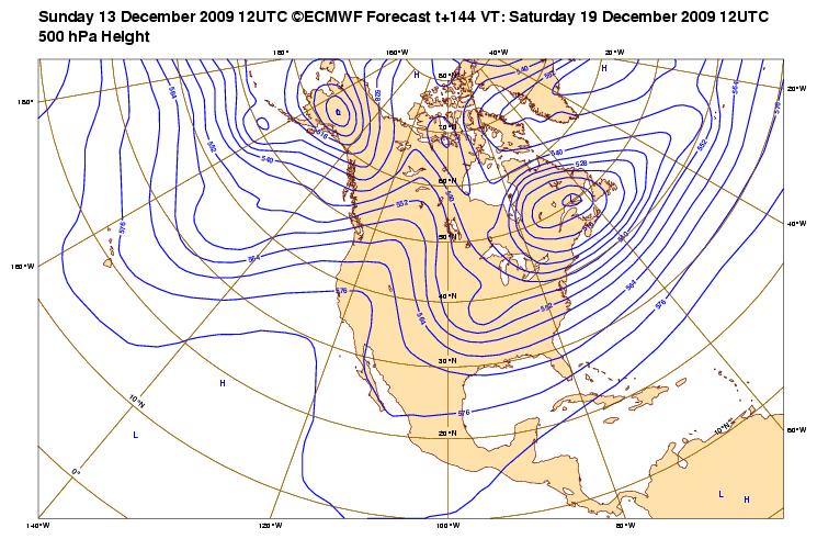
12Z ECMWF looks interesting. 
144 Hour
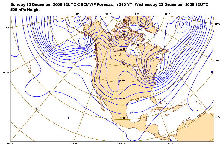
240 Hour
Take a peek at the Cold Air in Canada...Hmmm...
144 Hour
240 Hour
EXTENDED FORECAST DISCUSSION
NWS HYDROMETEOROLOGICAL PREDICTION CENTER CAMP SPRINGS MD
1254 PM EST SUN DEC 13 2009
VALID 12Z WED DEC 16 2009 - 12Z SUN DEC 20 2009
OVER THE CENTRAL AND ERN US/ATLANTIC...
A DEEP CLOSED LOW IS EXPECTED TO DEVELOP OVER THE CANADIAN
MARITIMES MID-LATE WEEK... UNDERCUTTING A STRONG BLOCKING RIDGE
BUILDING FROM GREENLAND. LARGE MODEL DIFFERENCES BECOME EVIDENT
THU ONWARD REGARD TO THE SLOW MOVING CLOSED CIRCULATION LOCATION
AND THE RESULTING PATTERN UPSTREAM OVER THE EASTERN HALF OF THE
NATION. THE ECMWF/CMC ARE MORE PROGRESSIVE IN THIS PATTERN THAN
THE GFS/UKMET WITH THE CLOSED LOW...ALLOWING A SURFACE HIGH TO
BUILD MORE INTO THE GREAT LAKES AND NORTHEAST NEXT WEEKEND. MODELS
HAVE TRENDED TOWARD A DEVELOPING SYSTEM FROM THE CENTRAL/SRN
PLAINS TO THE MID-MS VALLEY AREA FRI/SAT THAT PROGRESSES EWD SUN.
THE ECMWF/CMC ALSO SHOW MORE ORGANIZED FORMATION OF A GULF LOW
THAT PUSHES TOWARD THE SE US COAST LATE PERIOD. A QUICK RESPECTIVE
COMPARISON OF THE 00/06/12 UTC GFS OR PAST FEW ECMWF RUNS SHOW
POOR RUN TO RUN MODEL CONSISTENCY WITH THESE FEATURES...LENDING
VERY LOW FORECAST CONFIDENCE. PREFER TO ACCORDINGLY BLEND HIGHLY
SMOOTHED GFS/ECMWF ENSEMBLE MEAN GUIDANCE THAT ESPECIALLY BY LATE
WEEK MINIMIZES DEPICTION OF ANY LOWLY PREDICTABLE ORGANIZED
SYSTEMS. HOWEVER...FINAL HPC PROGS CONTINUE TO LEAN MORE ON THE
ECMWF ENSEMBLE THAT OFFERS SOMEWHAT LOWER MEAN PRESSURES ACROSS
THE E-CENTRAL US IN THE REGION WHERE DETERMINISTIC MODELS FAVOR
POSSIBLE SYSTEM DEVELOPMENTS.
OVER THE PAC/WRN US...
AN ONSHORE JET WITH EMBEDDED ENERGY IS PROGGED TO REACH INTO THE
NWRN U.S. AND SWRN CANADA WED/THU...WITH AN AMPLIFYING RIDGE
DEVELOPING THEREAFTER OVER WRN NOAM DOWNSTREAM OF A PERSISTENT
GULF OF AK/AK MEAN POLAR VORTEX. WHILE GUIDANCE SEEMS IN
REASONABLE LARGER SCALE AGREEMENT FROM THE ERN PAC ACROSS THE WRN
STATES...00 UTC SOLUTION SPREAD IS DECREASED SIGNIFICANTLY BY
INCLUDING THE 06 OR 12 UTC GFS RUNS TO THAT GUIDANCE MIX INSTEAD
THE 00 UTC GFS THAT SEEMS TO CRASH THE WRN CAN/NW US MID-UPPER
LEVEL RIDGE MUCH TOO ROBUSTLY FRI-SUN GIVEN UPSTREAM LONGWAVE
FLOW. FINAL HPC PROGS REMAIN PRIMARILY DERIVED FROM A BLEND OF
ECMWF AND GFS ENSEMBLE MEANS DAYS 4-7 IN AN EFFORT TO MITIGATE
SMALLER SCALE ERROR.
HEDGE/SCHICHTEL
Take a peek at the Cold Air in Canada...Hmmm...
0 likes
Carla/Alicia/Jerry(In The Eye)/Michelle/Charley/Ivan/Dennis/Katrina/Rita/Wilma/Ike/Harvey
Member: National Weather Association
Wx Infinity Forums
http://wxinfinity.com/index.php
Facebook.com/WeatherInfinity
Twitter @WeatherInfinity
Member: National Weather Association
Wx Infinity Forums
http://wxinfinity.com/index.php
Facebook.com/WeatherInfinity
Twitter @WeatherInfinity

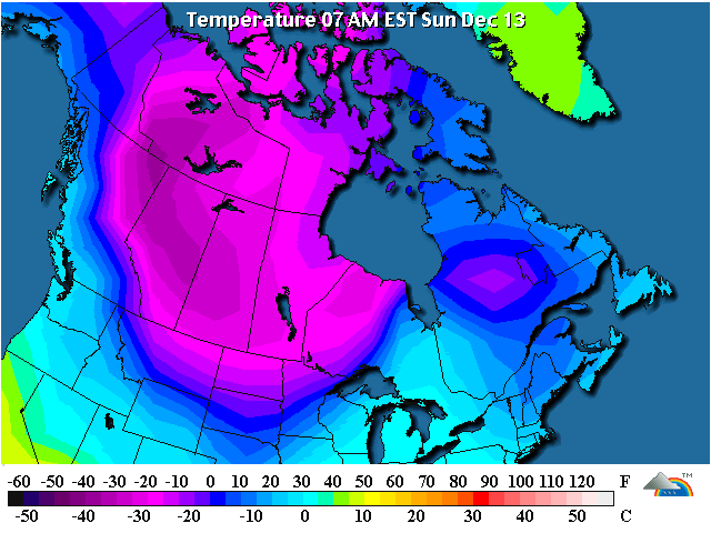
That is a mighty large area of below zero temps. Sometimes I think we forget how big the mass of cold air can be up in Canada.
0 likes
The above post and any post by Ntxw is NOT an official forecast and should not be used as such. It is just the opinion of the poster and may or may not be backed by sound meteorological data. It is NOT endorsed by any professional institution including Storm2k. For official information, please refer to NWS products.
Help support Storm2K!


Re:
Ntxw wrote:That is a mighty large area of below zero temps. Sometimes I think we forget how big the mass of cold air can be up in Canada.
Very true. Quite a massive reservoir of very cold air up there. Question is will there be a triggering mechanism to dislodge that air and when it gets dislodged what direction will it head? Due south or more of a south/southeast direction?
Will we only get glancing blows here in Texas or will it head towards the southeast part of the country?
0 likes
-
srainhoutx
- S2K Supporter
- Posts: 6919
- Age: 68
- Joined: Sun Jan 14, 2007 11:34 am
- Location: Haywood County, NC
- Contact:
Re: Texas winter wx thread (2009-2010)
A nugget from San Angelo this afternoon in AFD regarding next weekend...
Welcome to El Nino Winters and poor model continuity.
UNCERTAINTY IN THE FORECAST INCREASES LATE IN THE WEEK. THE MODELS
GENERALLY AGREE THAT THERE WILL BE SIGNIFICANT AMPLIFICATION OF
THE LONGWAVE PATTERN ACROSS THE CONUS DURING THIS PERIOD TO WHAT
IS CALLED A POSITIVE PNA PATTERN (WESTERN RIDGE-EASTERN TROUGH).
NORTH TO NORTHWEST FLOW ALOFT WILL DEVELOP OVER THE PLAINS WHICH
WILL LEAD TO ANOTHER COLD FRONT ON FRIDAY OR SATURDAY. THE GFS
TODAY HAS SPED UP THE FRONT TO FRIDAY...WHILE THE ECMWF STILL
SUGGESTS SATURDAY WILL BE THE DAY. NEVERTHELESS...IN THIS TYPE OF
PATTERN THE COLDEST AIR USUALLY STAYS TO OUR NORTH AND EAST AND
DOWNSLOPE MODERATES THE AIR MASS OVER OUR REGION SOME. SO
TEMPERATURES WILL NOT BE AS COLD AS WE`VE SEEN WITH THE RECENT
ARCTIC INTRUSIONS AS IT APPEARS NOW. ANOTHER ISSUE WILL BE HOW FAR
WEST THE INITIAL SHORTWAVE TROUGH DIGS INTO THE SOUTH CENTRAL US.
THE CURRENT GFS/ECMWF BRING IT FAR ENOUGH EAST TO KEEP MY FCST
AREA DRY. SOME OF THE GFS ENSEMBLE MEMBERS AND THE UKMET...HOWEVER...DIG
THE SYSTEM FARTHER WEST AND BRING SOME PRECIP TO OUR AREA. FOR
RIGHT NOW...I WILL KEEP THE DRY STATUS QUO UNTIL MORE CONFIDENCE
CAN BE OBTAINED IN HOW THIS PATTERN WILL EVOLVE.
LACY
Welcome to El Nino Winters and poor model continuity.
0 likes
Carla/Alicia/Jerry(In The Eye)/Michelle/Charley/Ivan/Dennis/Katrina/Rita/Wilma/Ike/Harvey
Member: National Weather Association
Wx Infinity Forums
http://wxinfinity.com/index.php
Facebook.com/WeatherInfinity
Twitter @WeatherInfinity
Member: National Weather Association
Wx Infinity Forums
http://wxinfinity.com/index.php
Facebook.com/WeatherInfinity
Twitter @WeatherInfinity
Re: Texas winter wx thread (2009-2010)
It's a little comical to read their flip flopping opinions. Pretty tough to get a handle on things.
This passage doesn't fill me with much confidence, though.
This passage doesn't fill me with much confidence, though.
IN THIS TYPE OF PATTERN THE COLDEST AIR USUALLY STAYS TO OUR NORTH AND EAST AND
DOWNSLOPE MODERATES THE AIR MASS OVER OUR REGION SOME. SO
TEMPERATURES WILL NOT BE AS COLD AS WE`VE SEEN WITH THE RECENT
ARCTIC INTRUSIONS AS IT APPEARS NOW.
0 likes
-
srainhoutx
- S2K Supporter
- Posts: 6919
- Age: 68
- Joined: Sun Jan 14, 2007 11:34 am
- Location: Haywood County, NC
- Contact:
Re: Texas winter wx thread (2009-2010)
Well if that doesn't give you any confidence, look what Lubbock just issued...
The forecasting nightmare will likely continue for the rest of the month IMHO.
.LONG TERM...
THE PERIPHERAL INFLUENCE OF AN ARCTIC AIR INTRUSION MONDAY NIGHT/TUESDAY
CONTINUES TO COMPLICATE THE FORECAST.
AS MENTIONED ABOVE...AN INITIAL FROPA IS EXPECTED TO BACKDOOR ACROSS
THE SOUTH PLAINS LATE MONDAY. THE POST FRONTAL AIRMASS IS CURRENTLY
CHARACTERIZED BY ZERO/SUB ZERO TEMPERATURES ON SNOWPACK OVER THE
CENTRAL/NORTHERN PLAINS...AND THE CORE OF THIS AIRMASS CONTAINS
-30 DEGREE TEMPS OVER PARTS OF BC/NWT ATTM. COLD SURFACE RIDGING
WILL GRADUALLY BUILD OVER THE SOUTH PLAINS MONDAY NIGHT/TUESDAY
UPON UPSLOPE SURFACE WINDS. MEANWHILE A NOTABLY SHARP SHORTWAVE
TROUGH WILL TRANSLATE OVER THE SOUTHERN ROCKIES. MODELS CONTINUE
TO DEPICT LIGHT QPF WITHIN A ZONE OF SHALLOW ISENTROPIC ASCENT IN
ADVANCE OF THIS FEATURE OVER THE SOUTHWESTERN FA BY SUNRISE TUESDAY.
GIVEN THE COLD/SHALLOW NATURE OF THE POST FRONTAL AIR...WE /IN
COORDINATION WITH SURROUNDING OFFICES/ HAVE TRENDED TEMPERATURES
SOME 10 DEGREES BELOW MOS. THIS LEADS TO SOME CONCERN THAT MODEL
DERIVED TEMPS/PROFILES WHICH CURRENTLY DEPICT LOW LEVEL WET BULB
TEMPS AROUND +5 DEGREES C MAY BE TOO WARM...AND THAT AT LEAST SOME
MENTION OF MIXED PRECIP IS WARRANTED. NO INDICATIONS OF SIGNIFICANT
WINTER WEATHER ARE PRESENT ATTM...AND ANY PRECIP THAT MATERIALIZES
SHOULD BE ENDING BY 12-18Z TUESDAY.
RETURN SOUTHERLY WINDS ARE PROGGED WEDNESDAY AS THE FLOW ALOFT
BECOMES NEAR ZONAL IN THE WAKE OF THE DEPARTING WAVE. MODELS STILL
LINGER A BROAD NOSE OF REMNANT SURFACE RIDGING AS THE MODIFIED
ARCTIC HIGH TRANSLATES EASTWARD OVER THE MID MISSISSIPPI/OHIO
VALLEYS. THUS MODERATION MAY INITIALLY BE GRADUAL...BUT NEAR
SEASONAL TEMPERATURES SEEM REASONABLE BY LATE WEDNESDAY/THURSDAY.
MEDIUM RANGE SOLUTIONS SUGGEST THE UA PATTERN WILL AMPLIFY AGAIN
BY LATE THURSDAY/FRIDAY...PROMOTING A RENEWED PUSH OF COLD AIR FROM
THE SAME WESTERN CANADA SOURCE REGION. THUS FORECAST HIGHS HAVE
BEEN LOWERED FRIDAY AND INTO SATURDAY...STILL PRECIP CHANCES SEEM
NEGLIGIBLE.
The forecasting nightmare will likely continue for the rest of the month IMHO.
0 likes
Carla/Alicia/Jerry(In The Eye)/Michelle/Charley/Ivan/Dennis/Katrina/Rita/Wilma/Ike/Harvey
Member: National Weather Association
Wx Infinity Forums
http://wxinfinity.com/index.php
Facebook.com/WeatherInfinity
Twitter @WeatherInfinity
Member: National Weather Association
Wx Infinity Forums
http://wxinfinity.com/index.php
Facebook.com/WeatherInfinity
Twitter @WeatherInfinity
-
srainhoutx
- S2K Supporter
- Posts: 6919
- Age: 68
- Joined: Sun Jan 14, 2007 11:34 am
- Location: Haywood County, NC
- Contact:
Re: Texas winter wx thread (2009-2010)
Portastorm wrote:OK srainhoutx asks to take a peek at the winter of 1972-73 so I have done that. The temperature and precip profiles are below for the December through February months of that winter. I believe this winter featured a strong El Nino (like this winter) and a month of December which was below normal temperature-wise for much of the nation east of the Rockies (somewhat like this winter).
Of interest, there was a South Texas snow event that winter on February 8, 1973, when 2 1/2 inches of snow fell in Del Rio, 2 inches in San Antonio, and Austin got a half inch (sounds like an upper level system scooting across South Texas to me!). I haven't been able to locate ice/sleet events historically or I would mention any of those as well.
TEMPERATURES 1972-73
PRECIP 1972-73


Good work Portastorm. SE TX saw 3 snow events. A impressive one in January, followed by 2 others in February. I might add the we saw a very dreary December with cloud cover/fog, drizzle and rather chilly temps IIRC. Sound familiar?
0 likes
Carla/Alicia/Jerry(In The Eye)/Michelle/Charley/Ivan/Dennis/Katrina/Rita/Wilma/Ike/Harvey
Member: National Weather Association
Wx Infinity Forums
http://wxinfinity.com/index.php
Facebook.com/WeatherInfinity
Twitter @WeatherInfinity
Member: National Weather Association
Wx Infinity Forums
http://wxinfinity.com/index.php
Facebook.com/WeatherInfinity
Twitter @WeatherInfinity
-
cycloneye

- Admin

- Posts: 148772
- Age: 69
- Joined: Thu Oct 10, 2002 10:54 am
- Location: San Juan, Puerto Rico
Re: Texas winter wx thread (2009-2010)
Portastorm,El Nino is right now in a moderate status not strong. 
http://www.cpc.ncep.noaa.gov/products/a ... ears.shtml

http://www.cpc.ncep.noaa.gov/products/a ... ears.shtml
0 likes
Visit the Caribbean-Central America Weather Thread where you can find at first post web cams,radars
and observations from Caribbean basin members Click Here
and observations from Caribbean basin members Click Here
-
Portastorm

- Storm2k Moderator

- Posts: 9918
- Age: 63
- Joined: Fri Jul 11, 2003 9:16 am
- Location: Round Rock, TX
- Contact:
Re: Texas winter wx thread (2009-2010)
cycloneye wrote:Portastorm,El Nino is right now in a moderate status not strong.
http://www.cpc.ncep.noaa.gov/products/a ... ears.shtml
Details, details ... cycloneye!
Point well taken. I have been so hung up on the latest trends in Nino Region 3.4 and 4 and the projections of it GOING strong that I didn't take into account the actual current readings of "moderate."
At least in terms of the Southern Plains and Texas, what is intriguing me is how the operational runs of the GFS and Euro in the last 24 hours have trended colder for this coming weekend. We have been talking a lot about the "step down" pattern and I believe that starts this week with the first shallow Polar airmass impacting us. After that, I believe we will see a series of increasingly colder airmasses plunging down into the US.
I would like to believe the southern jet will remain active so somebody in Southtown USA is bound to see some snow or ice. Whether it is us in Texas or elsewhere ... one of the big questions!
0 likes
-
cycloneye
- Admin
- Posts: 148772
- Age: 69
- Joined: Thu Oct 10, 2002 10:54 am
- Location: San Juan, Puerto Rico
Re: Texas winter wx thread (2009-2010)
Portastorm wrote:cycloneye wrote:Portastorm,El Nino is right now in a moderate status not strong.
http://www.cpc.ncep.noaa.gov/products/a ... ears.shtml
Details, details ... cycloneye!
Point well taken. I have been so hung up on the latest trends in Nino Region 3.4 and 4 and the projections of it GOING strong that I didn't take into account the actual current readings of "moderate."
At least in terms of the Southern Plains and Texas, what is intriguing me is how the operational runs of the GFS and Euro in the last 24 hours have trended colder for this coming weekend. We have been talking a lot about the "step down" pattern and I believe that starts this week with the first shallow Polar airmass impacting us. After that, I believe we will see a series of increasingly colder airmasses plunging down into the US.
I would like to believe the southern jet will remain active so somebody in Southtown USA is bound to see some snow or ice. Whether it is us in Texas or elsewhere ... one of the big questions!
Thats ok my friend.
0 likes
Visit the Caribbean-Central America Weather Thread where you can find at first post web cams,radars
and observations from Caribbean basin members Click Here
and observations from Caribbean basin members Click Here
-
aerology
- Tropical Depression

- Posts: 56
- Age: 78
- Joined: Sun Oct 18, 2009 2:38 am
- Location: Concordia, Kansas
- Contact:
Re: Texas winter wx thread (2009-2010)
weatherguy425 wrote:Not that it will actually come to fruition but models are notorious for losing sch events only to have them reappear a few days ahead of the event...
That is one of the problems with the current models the reference time frame is very narrow for initial conditions, and the past three days, a lot of times this will introduce presistance of inertia, to the medial flows, for several days, consistent with the actual flows, as the Lunar declinational atmospheric tides, make their runs across the equator from one poleward culmination to another.
Then as the tide turns and we have the severe weather bursts at declinational culmination, they get confused, or surprised, as the initial inertial effects reverse for about four days before the sweep to the other pole, that brings back the smooth flows, the models understand.
So that when the Lunar declination went to Maximum North on December 3rd, turbulence and shear introduced into the atmosphere, from the turning tide, (the models do not know about), surprised them with the usual couple of tornadoes. Now (12-13-09) that we are ~20 degrees South Lunar declination, the models have a full buffer, of five days of linear inertial, from the Moon's trip South across the equator (12-09-09) and is slowing it's movement.
Coming up on the Southern extent culmination, producing a secondary tidal bulge in the Northern Hemisphere, bringing us to the mid point of a 27.32 day declinational cycle (one of the four routine patterns that cycle on an 109.3 day period). This particular one (#1) that started back on Dec 3rd, has incursions of polar air masses that come down from Western Canada, through Montana and the Dakotas, to make up the Northern part of the atmospheric tidal bulge.
So I would expect to see a large invasion of cold dry air sweep almost all the way to the Gulf coast again, then the produced frontal boundary with the interesting weather, that includes change state intense precipitation. Freezing rain, where the warm over runs cold, and snow where the cold undercuts the more sluggish warm air, still moving North East by inertia alone, severe weather to form in that trailing edge of the warm moist mass, that gets swept from behind from the polar air mass that tries to follow the tidal bulge back to the equator, powering the cyclonic patterns generated by carolis forces, alone as the tide turns, and finishes out as the Moon approaches the equator again.
Expect the same type of interaction again for a primary bulge production by the passage back North, culminating on 12-30-09, pumping in a solid polar air mass very consistent with the pattern we had on 12-03-09, (the North lunar declination culmination), then (#2) the next Rossby wave / jet stream regime pattern, comes back into play with much more zonal flow, and air masses invading from the Pacific, (of the two sub types of) phase with lesser amounts of Gulf moisture entrainment in this one, more in the other #4.
The (#3) third 27.32 day pattern with polar air masses invading in from the Minnesota / Great Lakes area and sweeping out through the Eastern sea board, and mostly zonal flow out west, from 01-27-10 till 02-23-10, comes next.
The fourth 27.32 day cycle, that looks very similar to #2 but with much more moisture from the Gulf of Mexico.
usually has more hail and tornadoes associated with it than Pattern #4, and typically flows up Eastern side of tornado alley. Will be in effect from 02-23-10 through 03-22-10, and should produce the first big surge of severe tornado production, from about March 20th 2010, until about March 26 or later as the Next polar air mass cycle is coming out of western Canada, and should make for steep temperature gradients, and ion content differences.
Richard Holle
(I would love to point you to the Beta maps of all the Days in question, but Admin permission for that is still pending)
0 likes
-
cctxhurricanewatcher

- Category 5

- Posts: 1206
- Joined: Sun Sep 12, 2004 8:53 pm
- Location: Corpus Christi, Texas
Re: Texas winter wx thread (2009-2010)
Major bust in Corpus with the temps. Even with the morning updates ,the predicted a high in the mid to upper 60's. We didn't get out of the mid 50's.
I think the next two or three weeks are going to be very interesting with our local NWS offices. Sort of almost like the curve balls they get thrown during the heart of hurricane season. Larry Costgrove's weekend update was very telling.
http://www.examiner.com/x-3775-Houston- ... -600-PM-CT
And JB is on board too.
0 likes
I understand the bust of these local forecasts, however the eastern\southeastern parts of Texas the clouds and fog never truly burned off (Yes they should have adjusted the highs accordingly) but as we all know even locally a few miles away clearing and sunshine dramatically warms things up. So you can't fully blame the weather forecasters for such busts. For example today here in the metroplex Dallas' high barely got up to 60 while over in Fort Worth, within 30 miles of each other, it was a good 10 degrees warmer where the clouds broke up.
0 likes
The above post and any post by Ntxw is NOT an official forecast and should not be used as such. It is just the opinion of the poster and may or may not be backed by sound meteorological data. It is NOT endorsed by any professional institution including Storm2k. For official information, please refer to NWS products.
Help support Storm2K!
Help support Storm2K!
-
srainhoutx
- S2K Supporter
- Posts: 6919
- Age: 68
- Joined: Sun Jan 14, 2007 11:34 am
- Location: Haywood County, NC
- Contact:
Re: Texas winter wx thread (2009-2010)
cctxhurricanewatcher wrote:I think the next two or three weeks are going to be very interesting with our local NWS offices. Sort of almost like the curve balls they get thrown during the heart of hurricane season. Larry Costgrove's weekend update was very telling.
http://www.examiner.com/x-3775-Houston- ... -600-PM-CT
And JB is on board too.
Great catch cctxhurricanewatcher. There are many folks, both "pros" and enthusiasts that have been watching this pattern earnestly since early November. I have enjoyed the great discussions in this thread and hope those that have not watched long range Winter Weather Patterns have learned some things along the way. The trends continue to look very interesting and look forward to the surprises ahead in the coming days and weeks.
Last edited by srainhoutx on Sun Dec 13, 2009 9:05 pm, edited 1 time in total.
0 likes
Carla/Alicia/Jerry(In The Eye)/Michelle/Charley/Ivan/Dennis/Katrina/Rita/Wilma/Ike/Harvey
Member: National Weather Association
Wx Infinity Forums
http://wxinfinity.com/index.php
Facebook.com/WeatherInfinity
Twitter @WeatherInfinity
Member: National Weather Association
Wx Infinity Forums
http://wxinfinity.com/index.php
Facebook.com/WeatherInfinity
Twitter @WeatherInfinity
Re: Texas winter wx thread (2009-2010)
This was very interesting from Larry's long range forecast.
A sharp drop in temperature appears likely after December 18, when the aforementioned southern branch churns out a significant winter storm. If that disturbance phases with the cAk gyre entering the Northeast (which appears likely at this point), then pretty much everyone living to the right of the Continental Divide (including much of Mexico and Cuba!) can expect a period of near-record cold that could last into New Years' Eve.
0 likes
-
wxgirl69
- Tropical Storm
- Posts: 120
- Age: 56
- Joined: Wed Nov 18, 2009 9:32 pm
- Location: Deer Park, Texas
Re: Texas winter wx thread (2009-2010)
severe wrote:This was very interesting from Larry's long range forecast.A sharp drop in temperature appears likely after December 18, when the aforementioned southern branch churns out a significant winter storm. If that disturbance phases with the cAk gyre entering the Northeast (which appears likely at this point), then pretty much everyone living to the right of the Continental Divide (including much of Mexico and Cuba!) can expect a period of near-record cold that could last into New Years' Eve.
WOW!!! That would be amazing.. I can't wait to see how this will play out. I seen many long term colds bust.. Something tells me this winter will be different..Call it womans tuition.. (spelling)?? and you know we are always right. LOL
0 likes
Who is online
Users browsing this forum: Brent, bubba hotep, cajungal, gboudx, hurricane2025, Ntxw, rwfromkansas, South Texas Storms, ThunderSleetDreams, txtwister78, Will_TX, Wthrfan and 204 guests