
Texas Winter 2014-2015
Moderator: S2k Moderators
Forum rules
 The posts in this forum are NOT official forecast and should not be used as such. They are just the opinion of the poster and may or may not be backed by sound meteorological data. They are NOT endorsed by any professional institution or STORM2K.

The posts in this forum are NOT official forecast and should not be used as such. They are just the opinion of the poster and may or may not be backed by sound meteorological data. They are NOT endorsed by any professional institution or STORM2K.
-
Rgv20

- S2K Supporter

- Posts: 2466
- Age: 39
- Joined: Wed Jan 05, 2011 5:42 pm
- Location: Edinburg/McAllen Tx
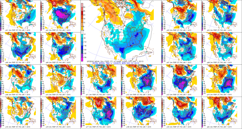
12zGFS Ensemble 2Meter Temperature Means for the first day of 2015...16-20 degrees fahrenheit below normal for South Texas.
0 likes
The following post is NOT an official forecast and should not be used as such. It is just the opinion of the poster and may or may not be backed by sound meteorological data. It is NOT endorsed by any professional institution including storm2k.org For Official Information please refer to the NHC and NWS products.
-
CYCLONE MIKE
- Category 5

- Posts: 2183
- Joined: Tue Aug 31, 2004 6:04 pm
- Location: Gonzales, LA
Re: Texas Winter 2014-2015
Liking what I'm seeing for south LA, cold and a gulf low spinning up. Sure it will probably be freezing rain but at least its some kind of winter precip 
But on the other hand I'm sure by tomorrow or Wednesday it will be showing dry and warm for next week.
But on the other hand I'm sure by tomorrow or Wednesday it will be showing dry and warm for next week.
0 likes

I'm far from convinced we are going to see a major cold outbreak in Texas. All we can do is hurry up and wait.
0 likes
The above post and any post by dhweather is NOT an official forecast and should not be used as such. It is just the opinion of the poster and may or may not be backed by sound meteorological data. It is NOT endorsed by any professional institution including storm2k.org. For official information, please refer to NWS products.


Lets see how much this is worth in 24 hours.

0 likes
The above post and any post by Ntxw is NOT an official forecast and should not be used as such. It is just the opinion of the poster and may or may not be backed by sound meteorological data. It is NOT endorsed by any professional institution including Storm2k. For official information, please refer to NWS products.
Help support Storm2K!
-
orangeblood
- S2K Supporter
- Posts: 3895
- Joined: Tue Dec 15, 2009 6:14 pm
- Location: Fort Worth, TX
Re: Texas Winter 2014-2015
GFS continues to trend stronger with the Arctic HP early next week/500 mb textbook setup for a variety of winter weather across Texas...1054 HP entering Montana a week from today.

0 likes

Read McFarland's paper and you can learn all about that backwards S!
http://www.srh.noaa.gov/srh/ssd/techmemo/tm88.htm
And it's not like the GFS is alone.

0 likes
The above post and any post by Ntxw is NOT an official forecast and should not be used as such. It is just the opinion of the poster and may or may not be backed by sound meteorological data. It is NOT endorsed by any professional institution including Storm2k. For official information, please refer to NWS products.
Help support Storm2K!
Help support Storm2K!
Re: Texas Winter 2014-2015
Parallel GFS has a massive 1060mb HP in Montana @ 174 hrs then drops it into the central plains as 1056mb. 
Need to watch that Canadian source region to see how much colder it gets in the coming week.
Need to watch that Canadian source region to see how much colder it gets in the coming week.
0 likes
-
Rgv20
- S2K Supporter
- Posts: 2466
- Age: 39
- Joined: Wed Jan 05, 2011 5:42 pm
- Location: Edinburg/McAllen Tx
0zGFS Parallel came a bit on the chilly side...... 

New Years Morning..
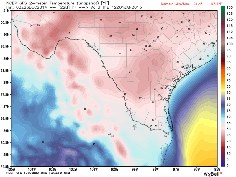
Most of the Snowfall occurs early morning thru out New Years day..

New Years Morning..

Most of the Snowfall occurs early morning thru out New Years day..

0 likes
The following post is NOT an official forecast and should not be used as such. It is just the opinion of the poster and may or may not be backed by sound meteorological data. It is NOT endorsed by any professional institution including storm2k.org For Official Information please refer to the NHC and NWS products.
-
orangeblood
- S2K Supporter
- Posts: 3895
- Joined: Tue Dec 15, 2009 6:14 pm
- Location: Fort Worth, TX
Re: Texas Winter 2014-2015
0 likes
-
orangeblood
- S2K Supporter
- Posts: 3895
- Joined: Tue Dec 15, 2009 6:14 pm
- Location: Fort Worth, TX
Re: Texas Winter 2014-2015
Rgv20 - hate to throw this out there but the famous Christmas Eve 2004 analog came up when comparing 500 mb charts for next week....more of a full latitude trough in 2004 than the backwards S/Rex Block the models are showing but there are some similarities!!
0 likes
-
Rgv20
- S2K Supporter
- Posts: 2466
- Age: 39
- Joined: Wed Jan 05, 2011 5:42 pm
- Location: Edinburg/McAllen Tx
Re: Texas Winter 2014-2015
orangeblood wrote:Rgv20 - hate to throw this out there but the famous Christmas Eve 2004 analog came up when comparing 500 mb charts for next week....more of a full latitude trough in 2004 than the backwards S/Rex Block the models are showing but there are some similarities!!
You made my heart skip! Christmas 2004?!?!
0zCMC has a 1055 High and Navgem has a 1044 high coming down the spine of the Rockies Tuesday Morning....Euro up next!
EDIT: 0zCMC loves Texas!


Last edited by Rgv20 on Tue Dec 23, 2014 12:47 am, edited 1 time in total.
0 likes
The following post is NOT an official forecast and should not be used as such. It is just the opinion of the poster and may or may not be backed by sound meteorological data. It is NOT endorsed by any professional institution including storm2k.org For Official Information please refer to the NHC and NWS products.
-
TeamPlayersBlue

- Category 5
- Posts: 3530
- Joined: Tue Feb 02, 2010 1:44 am
- Location: Denver/Applewood, CO
Re: Texas Winter 2014-2015
orangeblood wrote:Rgv20 - hate to throw this out there but the famous Christmas Eve 2004 analog came up when comparing 500 mb charts for next week....more of a full latitude trough in 2004 than the backwards S/Rex Block the models are showing but there are some similarities!!
Oh rearry..... My first Christmas in Houston even though growing up here, one of the most memorable nights of my life! Not sure how the upper air is similar for this pattern though. That was a really really cold system though.
My .02... If only the HP's didnt go so far west, but i think that has to do with the Blocking being so strong in Alaska, the upper air pulls the HP a bit more SW then normal. GFS is putting well over an inch of precip in the Houston area. Lets hope the models have a bit of an issue with the cold air and it will bleed further down then expected.
Staying up for the Euro to see what it predicts.
0 likes
Personal Forecast Disclaimer:
The posts in this forum are NOT official forecast and should not be used as such. They are just the opinion of the poster and may or may not be backed by sound meteorological data. They are NOT endorsed by any professional institution or storm2k.org. For official information, please refer to the NHC and NWS products.
The posts in this forum are NOT official forecast and should not be used as such. They are just the opinion of the poster and may or may not be backed by sound meteorological data. They are NOT endorsed by any professional institution or storm2k.org. For official information, please refer to the NHC and NWS products.
-
orangeblood
- S2K Supporter
- Posts: 3895
- Joined: Tue Dec 15, 2009 6:14 pm
- Location: Fort Worth, TX
Re: Texas Winter 2014-2015
Well ironically, the GEM served it up for me....here you go
Latest GEM Run

Christmas Eve 2004

The current upper air pattern might even be colder than back in 2004 due to a much bigger ridge all the way up into the Arctic Circle
Latest GEM Run
Christmas Eve 2004
The current upper air pattern might even be colder than back in 2004 due to a much bigger ridge all the way up into the Arctic Circle
0 likes


Re: Texas Winter 2014-2015
orangeblood wrote:GFS continues to trend stronger with the Arctic HP early next week/500 mb textbook setup for a variety of winter weather across Texas...1054 HP entering Montana a week from today.
What kind of temps in SE Texas would we be looking at if that happened?
0 likes
-
Rgv20
- S2K Supporter
- Posts: 2466
- Age: 39
- Joined: Wed Jan 05, 2011 5:42 pm
- Location: Edinburg/McAllen Tx
0zGFS Ensemble Means have a 1050mb High entering Montana late Monday Night...Pretty impressive for being an Ensemble Mean 7 days out!


0 likes
The following post is NOT an official forecast and should not be used as such. It is just the opinion of the poster and may or may not be backed by sound meteorological data. It is NOT endorsed by any professional institution including storm2k.org For Official Information please refer to the NHC and NWS products.

Re: Texas Winter 2014-2015
So, according to this, does that show a major ice storm for SW Louisiana?
0 likes
-
TeamPlayersBlue
- Category 5
- Posts: 3530
- Joined: Tue Feb 02, 2010 1:44 am
- Location: Denver/Applewood, CO
Re: Texas Winter 2014-2015
Yeah thats nearly identical. Woah. I could see it before i even scrolled down to the 2004 chart. Beauty.
0 likes
Personal Forecast Disclaimer:
The posts in this forum are NOT official forecast and should not be used as such. They are just the opinion of the poster and may or may not be backed by sound meteorological data. They are NOT endorsed by any professional institution or storm2k.org. For official information, please refer to the NHC and NWS products.
The posts in this forum are NOT official forecast and should not be used as such. They are just the opinion of the poster and may or may not be backed by sound meteorological data. They are NOT endorsed by any professional institution or storm2k.org. For official information, please refer to the NHC and NWS products.
-
TeamPlayersBlue
- Category 5
- Posts: 3530
- Joined: Tue Feb 02, 2010 1:44 am
- Location: Denver/Applewood, CO
The Canadian looks very similar to 2004 as well
0 likes
Personal Forecast Disclaimer:
The posts in this forum are NOT official forecast and should not be used as such. They are just the opinion of the poster and may or may not be backed by sound meteorological data. They are NOT endorsed by any professional institution or storm2k.org. For official information, please refer to the NHC and NWS products.
The posts in this forum are NOT official forecast and should not be used as such. They are just the opinion of the poster and may or may not be backed by sound meteorological data. They are NOT endorsed by any professional institution or storm2k.org. For official information, please refer to the NHC and NWS products.
-
TheProfessor

- Professional-Met

- Posts: 3506
- Age: 29
- Joined: Tue Dec 03, 2013 10:56 am
- Location: Wichita, Kansas
-
TheProfessor
- Professional-Met
- Posts: 3506
- Age: 29
- Joined: Tue Dec 03, 2013 10:56 am
- Location: Wichita, Kansas
Btw has anyone been looking at Saturday night? I don't have my computer so I can't look at the models, but NWS has my area in North Texas having a low of 31 with a 20% chance of precipitation. Of course it would depend on when precipitation would fall, but maybe it could be sorta interesting?
0 likes
An alumnus of The Ohio State University.
Your local National Weather Service office is your best source for weather information.
Your local National Weather Service office is your best source for weather information.
Who is online
Users browsing this forum: No registered users and 32 guests