Texas winter wx thread (2009-2010)

Winter Weather Discussion

Moderator: S2k Moderators

Forum rules

The posts in this forum are NOT official forecast and should not be used as such. They are just the opinion of the poster and may or may not be backed by sound meteorological data. They are NOT endorsed by any professional institution or STORM2K.

Help Support Storm2K
Message
Author
snow and ice
Tropical Depression
Tropical Depression
Posts: 92
Joined: Sun Oct 04, 2009 9:56 pm

Re: Texas winter wx thread (2009-2010)

#1141 Postby snow and ice » Mon Dec 14, 2009 1:20 pm

Portastorm wrote:First of all, ok ... c'mon now ... the GGEM?! The Canadian model scores the lowest in terms of reliability or so I have read. I also looked at it through 144 hours and saw nothing of "interest" at least for the Southern Plains and Texas. Wxman22, I agree with you!

Secondly, I did look at those 6z ensemble runs per snow and ice's note. Only two of the 12 ensembles showed an ice/snow event for parts of the central and southern parts of the state. However, about half did show pretty cold conditions for the northern part of Texas along with a threat for snow or ice.


You enjoy the weather...because it's the only weather you've got. I've heard that somewhere before.
0 likes   

User avatar
Portastorm
Storm2k Moderator
Storm2k Moderator
Posts: 9914
Age: 63
Joined: Fri Jul 11, 2003 9:16 am
Location: Round Rock, TX
Contact:

Re: Texas winter wx thread (2009-2010)

#1142 Postby Portastorm » Mon Dec 14, 2009 1:23 pm

snow and ice wrote:
Portastorm wrote:First of all, ok ... c'mon now ... the GGEM?! The Canadian model scores the lowest in terms of reliability or so I have read. I also looked at it through 144 hours and saw nothing of "interest" at least for the Southern Plains and Texas. Wxman22, I agree with you!

Secondly, I did look at those 6z ensemble runs per snow and ice's note. Only two of the 12 ensembles showed an ice/snow event for parts of the central and southern parts of the state. However, about half did show pretty cold conditions for the northern part of Texas along with a threat for snow or ice.


You enjoy the weather...because it's the only weather you've got. I've heard that somewhere before.


snow and ice ... you're really JB!!! Haaaa .... I love it. :lol:
0 likes   

User avatar
Portastorm
Storm2k Moderator
Storm2k Moderator
Posts: 9914
Age: 63
Joined: Fri Jul 11, 2003 9:16 am
Location: Round Rock, TX
Contact:

Re: Texas winter wx thread (2009-2010)

#1143 Postby Portastorm » Mon Dec 14, 2009 1:25 pm

srainhoutx wrote:Remember you have to use all the tools in the tool box in this type of setup. ALL guidance is struggling as we have seen for the past two or three weeks. As for the GGEM, it does show some "hints" in the Upper Air Pattern. Details and all the tools folks. We shall see, but that's my 0.02 cents worth.


Well, after another review ... the only thing that catches me eye from the Canadian 12z run is that it appears to retrograde a very strong vortex east to west across the Canadian/US border and drop the vortex into the western Great Lakes. Is that it? If that verifies, then yeah ... that could bring some real cold air down about 6-7 days out.
0 likes   

User avatar
srainhoutx
S2K Supporter
S2K Supporter
Posts: 6919
Age: 67
Joined: Sun Jan 14, 2007 11:34 am
Location: Haywood County, NC
Contact:

Re: Texas winter wx thread (2009-2010)

#1144 Postby srainhoutx » Mon Dec 14, 2009 1:27 pm

Portastorm wrote:
srainhoutx wrote:Remember you have to use all the tools in the tool box in this type of setup. ALL guidance is struggling as we have seen for the past two or three weeks. As for the GGEM, it does show some "hints" in the Upper Air Pattern. Details and all the tools folks. We shall see, but that's my 0.02 cents worth.


Well, after another review ... the only thing that catches me eye from the Canadian 12z run is that it appears to retrograde a very strong vortex east to west across the Canadian/US border and drop the vortex into the western Great Lakes. Is that it? If that verifies, then yeah ... that could bring some real cold air down about 6-7 days out.


Ding ding ding. Give that man a cigar! :cheesy:
0 likes   
Carla/Alicia/Jerry(In The Eye)/Michelle/Charley/Ivan/Dennis/Katrina/Rita/Wilma/Ike/Harvey

Member: National Weather Association
Wx Infinity Forums
http://wxinfinity.com/index.php

Facebook.com/WeatherInfinity
Twitter @WeatherInfinity

snow and ice
Tropical Depression
Tropical Depression
Posts: 92
Joined: Sun Oct 04, 2009 9:56 pm

Re: Texas winter wx thread (2009-2010)

#1145 Postby snow and ice » Mon Dec 14, 2009 1:28 pm

Portastorm wrote:
snow and ice wrote:
Portastorm wrote:First of all, ok ... c'mon now ... the GGEM?! The Canadian model scores the lowest in terms of reliability or so I have read. I also looked at it through 144 hours and saw nothing of "interest" at least for the Southern Plains and Texas. Wxman22, I agree with you!

Secondly, I did look at those 6z ensemble runs per snow and ice's note. Only two of the 12 ensembles showed an ice/snow event for parts of the central and southern parts of the state. However, about half did show pretty cold conditions for the northern part of Texas along with a threat for snow or ice.


You enjoy the weather...because it's the only weather you've got. I've heard that somewhere before.


snow and ice ... you're really JB!!! Haaaa .... I love it. :lol:


I wonder what his take is on all of this.
0 likes   

User avatar
cycloneye
Admin
Admin
Posts: 145422
Age: 68
Joined: Thu Oct 10, 2002 10:54 am
Location: San Juan, Puerto Rico

Re: Texas winter wx thread (2009-2010)

#1146 Postby cycloneye » Mon Dec 14, 2009 1:40 pm

To Portastorm and any member who is interested about how is El Nino behaving,here is the latest update.

Last week numbers:

Niño 4= +1.4ºC
Niño 3.4= +1.7ºC
Niño 3= +1.4ºC
Niño1+2= +0.4ºC

This week numbers:
Niño 4= +1.3ºC
Niño 3.4= +1.8ºC
Niño 3= +1.6ºC
Niño1+2= +0.2ºC


http://www.cpc.ncep.noaa.gov/products/a ... ts-web.pdf

Image
0 likes   
Visit the Caribbean-Central America Weather Thread where you can find at first post web cams,radars
and observations from Caribbean basin members Click Here

User avatar
southerngale
Retired Staff
Retired Staff
Posts: 27418
Joined: Thu Oct 10, 2002 1:27 am
Location: Southeast Texas (Beaumont area)

Re: Texas winter wx thread (2009-2010)

#1147 Postby southerngale » Mon Dec 14, 2009 1:47 pm

srainhoutx wrote:
Portastorm wrote:
srainhoutx wrote:A quick glance at the GGEM looks "interesting" as well.


Eh, I'm not letting you get away with just that srainhoutx! :lol:

Define "interesting" for those of us who haven't had time to see the GGEM.


I'm keeping my mouth shut until the EC and Ensembles arrive, Portastorm. There are plenty of other fine members here that can post their thoughts. Southerngale as put a muzzle on me. :cheesy: J/K SG. :P Besides, we would want Lucy to have too much information, would we. :wink:


I did no such thing! I just said if you're going to post about it, deliver it. :lol: I was trying to put pressure on you to make sure the models verify. You can do that, right?
0 likes   
Please support Storm2k by making a donation today. It is greatly appreciated! Click here: Image

Image my Cowboys Image my RocketsImage my Astros

User avatar
srainhoutx
S2K Supporter
S2K Supporter
Posts: 6919
Age: 67
Joined: Sun Jan 14, 2007 11:34 am
Location: Haywood County, NC
Contact:

Re: Texas winter wx thread (2009-2010)

#1148 Postby srainhoutx » Mon Dec 14, 2009 2:20 pm

12Z ECMWF run...

72 Hr

Image

96 Hr

Image

120 Hr

Image

144 Hr

Image

168 Hr

Image

192 Hr

Image

216 Hr

Image

240 Hr

Image

If the EC is correct, it suggests a strong push of cold air all the way into Mexico/Belize/Cuba. There appear to be some Upper Air disturbances riding along the N/NW flow. Also some potential for Sub Tropical Jet activity as well. We shall see. :wink:
0 likes   
Carla/Alicia/Jerry(In The Eye)/Michelle/Charley/Ivan/Dennis/Katrina/Rita/Wilma/Ike/Harvey

Member: National Weather Association
Wx Infinity Forums
http://wxinfinity.com/index.php

Facebook.com/WeatherInfinity
Twitter @WeatherInfinity

User avatar
srainhoutx
S2K Supporter
S2K Supporter
Posts: 6919
Age: 67
Joined: Sun Jan 14, 2007 11:34 am
Location: Haywood County, NC
Contact:

Re: Texas winter wx thread (2009-2010)

#1149 Postby srainhoutx » Mon Dec 14, 2009 2:46 pm

HPC seems to be biting on a stronger Arctic Aimass for the week of Christmas as well...

http://www.hpc.ncep.noaa.gov/medr/5dayfcst_wbg.gif
0 likes   
Carla/Alicia/Jerry(In The Eye)/Michelle/Charley/Ivan/Dennis/Katrina/Rita/Wilma/Ike/Harvey

Member: National Weather Association
Wx Infinity Forums
http://wxinfinity.com/index.php

Facebook.com/WeatherInfinity
Twitter @WeatherInfinity

User avatar
Big O
Category 1
Category 1
Posts: 252
Age: 55
Joined: Sun Sep 16, 2007 4:40 pm
Location: McAllen, Texas

Re: Texas winter wx thread (2009-2010)

#1150 Postby Big O » Mon Dec 14, 2009 3:25 pm

srainhoutx wrote:12Z ECMWF run...

72 Hr

Image

96 Hr

Image

120 Hr

Image

144 Hr

Image

168 Hr

Image

192 Hr

Image

216 Hr

Image

240 Hr

Image

If the EC is correct, it suggests a strong push of cold air all the way into Mexico/Belize/Cuba. There appear to be some Upper Air disturbances riding along the N/NW flow. Also some potential for Sub Tropical Jet activity as well. We shall see. :wink:


I'm not vey adept at reading models, but how do you know there would be a strong push of cold air into Mexico/Belize/Cuba. Although there appears to be some cold air transport from Canda, it would appear the flow goes zonal across Texas. Why wouldn't this suggest the cold being locked up to our north over the extreme northern portions of the Southern Plains.
0 likes   

User avatar
srainhoutx
S2K Supporter
S2K Supporter
Posts: 6919
Age: 67
Joined: Sun Jan 14, 2007 11:34 am
Location: Haywood County, NC
Contact:

Re: Texas winter wx thread (2009-2010)

#1151 Postby srainhoutx » Mon Dec 14, 2009 3:56 pm

:uarrow:

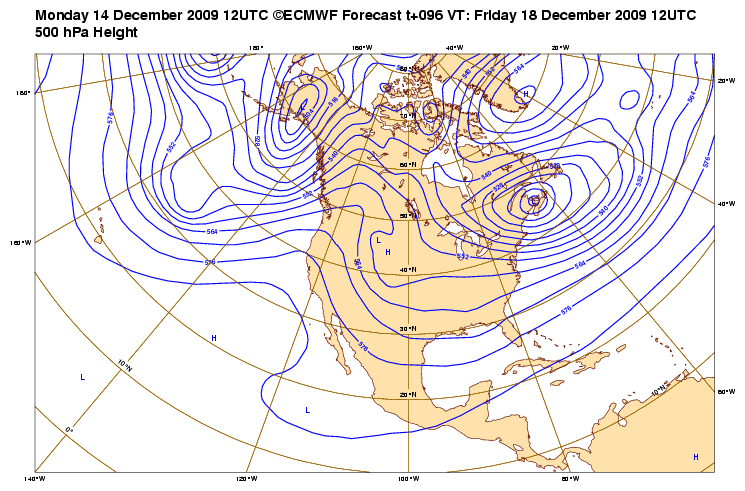
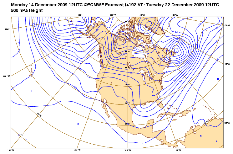
If you look at the 850mb charts for the ECMWF, you willl see that the front drops that far S. The free EC model available to the general public doesn't do justice to the guidance of the EC. Only NWS, some Pro Met as well as Pro Energy Mets have access to the 'finer' detailed data. It is very expensive from what I understand. I only posted the 500mb charts to show the Upper Flow Patterns. Others may want post those charts if so inclined. Also, there is still a lot of uncertainty in the medium and longer range, so take it all with a grain of salt. The guidance will likely flip flop over the next several day, before a reasonable solution becomes a bit clearer. I strongly believe that the NWS is keenly aware that the Holidays are approaching and will adderss the issues ahead after we get through the front today and tomorrow. You can already see that some WFO's as well as Pro Mets are discussing the affects and possible scenarios. It is a time when people are busy with Holiday Plans and Activities as well as travel plans. The chatter will likely increase in the days ahead if warranted to get folks attention IMHO, what ever thats worth.
0 likes   
Carla/Alicia/Jerry(In The Eye)/Michelle/Charley/Ivan/Dennis/Katrina/Rita/Wilma/Ike/Harvey

Member: National Weather Association
Wx Infinity Forums
http://wxinfinity.com/index.php

Facebook.com/WeatherInfinity
Twitter @WeatherInfinity

User avatar
Portastorm
Storm2k Moderator
Storm2k Moderator
Posts: 9914
Age: 63
Joined: Fri Jul 11, 2003 9:16 am
Location: Round Rock, TX
Contact:

Re: Texas winter wx thread (2009-2010)

#1152 Postby Portastorm » Mon Dec 14, 2009 4:08 pm

If I'm reading the 12z operational Euro correctly, the model is suggesting the possibility of an ice/snow event in north Texas overnight Friday into Saturday morning. The airmass appears to be cold enough and there's a lot of moisture at the 700 mb and 850 mb levels along with some upper-level energy going west to east.

http://www.meteo.psu.edu/~gadomski/ECMWF_12z/ecmwfloop.html
0 likes   

User avatar
Ntxw
Storm2k Moderator
Storm2k Moderator
Posts: 22786
Joined: Wed Oct 21, 2009 6:34 pm
Location: DFW, Texas

Re: Texas winter wx thread (2009-2010)

#1153 Postby Ntxw » Mon Dec 14, 2009 4:19 pm

Portastorm wrote:If I'm reading the 12z operational Euro correctly, the model is suggesting the possibility of an ice/snow event in north Texas overnight Friday into Saturday morning. The airmass appears to be cold enough and there's a lot of moisture at the 700 mb and 850 mb levels along with some upper-level energy going west to east.

http://www.meteo.psu.edu/~gadomski/ECMWF_12z/ecmwfloop.html


That's interesting I didn't notice it until you mentioned.
0 likes   
The above post and any post by Ntxw is NOT an official forecast and should not be used as such. It is just the opinion of the poster and may or may not be backed by sound meteorological data. It is NOT endorsed by any professional institution including Storm2k. For official information, please refer to NWS products.

  Help support Storm2K!
Help Support Storm2K

User avatar
cctxhurricanewatcher
Category 5
Category 5
Posts: 1206
Joined: Sun Sep 12, 2004 8:53 pm
Location: Corpus Christi, Texas

Re: Texas winter wx thread (2009-2010)

#1154 Postby cctxhurricanewatcher » Mon Dec 14, 2009 4:39 pm

Interesting note from NWS Brownsville in their PM AFD.

THE OVERALL PATTERN EVOLUTION OVER THE LOWER 48 STATES THROUGH
THURS. HOWEVER AFTER THURS THE ECMWF BEGINS TO DIVERGE FROM THE
GFS AND DIGS A MAJOR TROUGH AXIS OVER THE CENTRAL AND SOUTH
CENTRAL PLAINS STATES THROUGH NEXT WEEKEND. IF THIS VERFIES IT
WILL SET THE STAGE FOR ANOTHER REINFORCING SHORT OF CANADIAN AIR
NEXT WEEKEND. THE GFS MAINTAINS A MORE EASTWARD POSITIONED BROAD
TROUGH WITH A LESS DRAMATIC RESUPPLY OF COOLER AIR FROM THE NORTH.
RUN TO RUN CONSISTENCY WITH THE MAV AND NAM TEMPS AND POPS LOOKS
FAIR IN THE SHORT TERM WITH A VERY NARROW MAX AND MIN TEMP RANGE
EXPECTED FOR WED WITH THE EXPECTED OVERRUNNING EVENT. RUN TO RUN
CONSISTENCY WITH THE MEX TEMPS AND POPS IS ALSO FAIR AND HAVE GONE
NEAR OR BELOW GUIDANCE IN THE EXTENDED RANGE PERIOD.
&&
0 likes   

snow and ice
Tropical Depression
Tropical Depression
Posts: 92
Joined: Sun Oct 04, 2009 9:56 pm

Re: Texas winter wx thread (2009-2010)

#1155 Postby snow and ice » Mon Dec 14, 2009 5:33 pm

The CPC is certainly on board for the cold for the next two weeks:
6-10 day outlook:
http://www.cpc.ncep.noaa.gov/products/p ... ns/610day/

8-14 Day outlook:
http://www.cpc.ncep.noaa.gov/products/p ... /index.php
0 likes   

User avatar
vbhoutex
Storm2k Executive
Storm2k Executive
Posts: 29113
Age: 73
Joined: Wed Oct 09, 2002 11:31 pm
Location: Cypress, TX
Contact:

Re: Texas winter wx thread (2009-2010)

#1156 Postby vbhoutex » Mon Dec 14, 2009 5:40 pm

srainhoutx wrote:HPC seems to be biting on a stronger Arctic Aimass for the week of Christmas as well...

http://www.hpc.ncep.noaa.gov/medr/5dayfcst_wbg.gif

And that is indeed a huge bite they are taking. Gets more interesting by the hour just about. :cold: :eek:
0 likes   
Skywarn, C.E.R.T.
Please click below to donate to STORM2K to help with the expenses of keeping the site going:
Image

attallaman

Re:

#1157 Postby attallaman » Mon Dec 14, 2009 7:06 pm

jasons wrote:I'm watching with great interest the possibilities of some very cold air charging down the plains.

I drove through the neighborhood and took note of the freeze damage from last weekend:
- The Pygmy Dates may have total leaf loss
- Florida Gardenias will have total leaf loss and may have to be cut back significantly
- Annuals (Bananas, etc.), are toast
- Unprotected Majesty Palms have significant leaf burn
- Lantanas are toast
- Some leaf burn noted on Queen palms - it's pretty bad on some of the smaller ones
- Variegated Ginger has significant leaf burn
- Also noted: a Royal Palm in the inner loop on Bissonnet has significant leaf & crown burn. Too early to tell if the spear was killed.
- My protected Majesty Palms look like they survived, but the fronds are mush and bend in half - first time I've seen this happen.

All-in-all, this was the worst freeze I have seen in the Houston area since we moved here in 2005. If we get anything colder than what we got last weekend, it will be bad even in the urban core.
That's quite a list, do you have any sago palms, canary island palms or hybyscus(sp?) ?
0 likes   

User avatar
Ntxw
Storm2k Moderator
Storm2k Moderator
Posts: 22786
Joined: Wed Oct 21, 2009 6:34 pm
Location: DFW, Texas

Re: Texas winter wx thread (2009-2010)

#1158 Postby Ntxw » Mon Dec 14, 2009 8:42 pm

So does it look like anybody in Texas could get snow\ice this weekend? I have family starting to come in this weekend so important to know these things
0 likes   
The above post and any post by Ntxw is NOT an official forecast and should not be used as such. It is just the opinion of the poster and may or may not be backed by sound meteorological data. It is NOT endorsed by any professional institution including Storm2k. For official information, please refer to NWS products.


  Help support Storm2K!

Help Support Storm2K


User avatar
mysterymachinebl
Tropical Depression
Tropical Depression
Posts: 56
Age: 52
Joined: Tue Dec 18, 2007 12:19 pm
Location: Littleton, Co

Re: Texas winter wx thread (2009-2010)

#1159 Postby mysterymachinebl » Mon Dec 14, 2009 9:28 pm

Steve McCauley on WFAA tonight hinted at some possible major changes beginning this weekend. He said he may know a little more tonight at 10 after the latest model runs. It seems at least a few of the meteorologists in the area are picking up on some possible cold weather moving down towards next week.
0 likes   

User avatar
jasons2k
Storm2k Executive
Storm2k Executive
Posts: 8245
Age: 51
Joined: Wed Jul 06, 2005 12:32 pm
Location: The Woodlands, TX

Re: Re:

#1160 Postby jasons2k » Mon Dec 14, 2009 9:30 pm

attallaman wrote:That's quite a list, do you have any sago palms, canary island palms or hybyscus(sp?) ?


I have 5 sagos and they were unharmed - they are hardy down to the teens. I don't have any Canary Island dates but the ones in the area look unharmed as well, I believe they are hardy down to about 15-20.

I forgot to mention the hibiscus - and I have a lot. All my hibiscus got fried pretty badly. Total leaf loss and the top few inches of the branches are mush. They should come back though...that is unless we have another really hard freeze....
0 likes   


Return to “Winter Weather”

Who is online

Users browsing this forum: No registered users and 10 guests