Texas Winter 2015-2016

Winter Weather Discussion

Moderator: S2k Moderators

Forum rules

The posts in this forum are NOT official forecast and should not be used as such. They are just the opinion of the poster and may or may not be backed by sound meteorological data. They are NOT endorsed by any professional institution or STORM2K.

Help Support Storm2K
Message
Author
User avatar
Ntxw
Storm2k Moderator
Storm2k Moderator
Posts: 22786
Joined: Wed Oct 21, 2009 6:34 pm
Location: DFW, Texas

Re: Texas Winter 2015-2016

#1201 Postby Ntxw » Sun Dec 27, 2015 3:02 pm

Brent wrote:39 degrees here this was not forecast this early...


We'll need some help from the ULL and hope to not get dry slotted. Concern would not be the surface temperatures but the temps aloft and precip timing
0 likes   
The above post and any post by Ntxw is NOT an official forecast and should not be used as such. It is just the opinion of the poster and may or may not be backed by sound meteorological data. It is NOT endorsed by any professional institution including Storm2k. For official information, please refer to NWS products.

  Help support Storm2K!
Help Support Storm2K

JayDT
Category 1
Category 1
Posts: 354
Joined: Tue Dec 16, 2014 12:55 pm
Location: Dallas, Texas

#1202 Postby JayDT » Sun Dec 27, 2015 3:15 pm

38 degrees down here around Duncanville according to Weatherbug.
0 likes   

Ralph's Weather
S2K Supporter
S2K Supporter
Posts: 3269
Age: 38
Joined: Fri Dec 13, 2013 11:55 am
Location: Lindale, TX
Contact:

#1203 Postby Ralph's Weather » Sun Dec 27, 2015 3:21 pm

54 and about 4 inches of rain so far. My only shot at flurries is for the surface low to track close to Shreveport.
0 likes   
Follow on Facebook at Ralph's Weather.

User avatar
Ntxw
Storm2k Moderator
Storm2k Moderator
Posts: 22786
Joined: Wed Oct 21, 2009 6:34 pm
Location: DFW, Texas

#1204 Postby Ntxw » Sun Dec 27, 2015 3:27 pm

While the rest of us watch in envy, here is some images posted from the NWS Amarillo

Friona, you can see the truck

Image

Amarillo

Image
0 likes   
The above post and any post by Ntxw is NOT an official forecast and should not be used as such. It is just the opinion of the poster and may or may not be backed by sound meteorological data. It is NOT endorsed by any professional institution including Storm2k. For official information, please refer to NWS products.


  Help support Storm2K!

Help Support Storm2K


User avatar
TheAustinMan
Category 5
Category 5
Posts: 1047
Age: 25
Joined: Mon Jul 08, 2013 4:26 pm
Location: United States
Contact:

#1205 Postby TheAustinMan » Sun Dec 27, 2015 3:28 pm

500mb low sweeping in over the Big Bend:

Image
0 likes   
ImageImageImage
Treat my opinions with a grain of salt. For official information see your local weather service.

User avatar
TheProfessor
Professional-Met
Professional-Met
Posts: 3506
Age: 28
Joined: Tue Dec 03, 2013 10:56 am
Location: Wichita, Kansas

#1206 Postby TheProfessor » Sun Dec 27, 2015 3:29 pm

:uarrow: Hopefully the turn to the Northeast is delayed and just pushes eastward.
0 likes   
An alumnus of The Ohio State University.

Your local National Weather Service office is your best source for weather information.

User avatar
srainhoutx
S2K Supporter
S2K Supporter
Posts: 6919
Age: 67
Joined: Sun Jan 14, 2007 11:34 am
Location: Haywood County, NC
Contact:

Re: Texas Winter 2015-2016

#1207 Postby srainhoutx » Sun Dec 27, 2015 3:34 pm

Not so sure envy is a word I would use. :wink: Many recues are being attempted as folks ventured out on the roadways in the Panhandle during the 'lull'. Now convective thundersnow is being reported across much of the Midland WFO and moving into the SW area of Lubbock. Roads have 7 to 10 foot drifts. Most if not all roads in SE New Mexico are impassable with many folks trapped in their cars. This may well rival or pass the Christmas 1997 Blizzard for areas from Ruidoso on East to the Caprock.
0 likes   
Carla/Alicia/Jerry(In The Eye)/Michelle/Charley/Ivan/Dennis/Katrina/Rita/Wilma/Ike/Harvey

Member: National Weather Association
Wx Infinity Forums
http://wxinfinity.com/index.php

Facebook.com/WeatherInfinity
Twitter @WeatherInfinity

User avatar
Ntxw
Storm2k Moderator
Storm2k Moderator
Posts: 22786
Joined: Wed Oct 21, 2009 6:34 pm
Location: DFW, Texas

Re: Texas Winter 2015-2016

#1208 Postby Ntxw » Sun Dec 27, 2015 3:45 pm

srainhoutx wrote:Not so sure envy is a word I would use. :wink: Many recues are being attempted as folks ventured out on the roadways in the Panhandle during the 'lull'. Now convective thundersnow is being reported across much of the Midland WFO and moving into the SW area of Lubbock. Roads have 7 to 10 foot drifts. Most if not all roads in SE New Mexico are impassable with many folks trapped in their cars. This may well rival or pass the Christmas 1997 Blizzard for areas from Ruidoso on East to the Caprock.


Oh come on srain, you know we want to put our beloved wxman57 in it. He loves snow :wink:!

Hopefully everyone up there stays home and enjoy it rather than be on the road. It certainly gives that 1997 storm a run for it's money.

The guidance are now almost doing a full split of the PV at the lower levels near the troposphere. And with a -EPO/+PNA setting up shop we'll benefit from the -AO SSW event, a lot of cold air will make a straight bee-line down North America the next 4-8 weeks.
0 likes   
The above post and any post by Ntxw is NOT an official forecast and should not be used as such. It is just the opinion of the poster and may or may not be backed by sound meteorological data. It is NOT endorsed by any professional institution including Storm2k. For official information, please refer to NWS products.


  Help support Storm2K!

Help Support Storm2K


User avatar
SouthernMet
Category 3
Category 3
Posts: 857
Joined: Sun Aug 29, 2010 8:23 pm
Location: fort worth, tx

Re: Texas Winter 2015-2016

#1209 Postby SouthernMet » Sun Dec 27, 2015 3:56 pm

Conditions are very favorable for hail right now. We just had penny size hail in NRH/Keller area, and a trained spotter reported golf ball size hail near the northeast mall. Image
Last edited by SouthernMet on Sun Dec 27, 2015 4:00 pm, edited 1 time in total.
0 likes   
Nothing that SouthernMet posts, is an official forecast,nor does it reflect views of STORM2K.. SouthernMet is just adding to the great discussions on STORM2K.. Refer to NWS for official forecasts.

User avatar
TheProfessor
Professional-Met
Professional-Met
Posts: 3506
Age: 28
Joined: Tue Dec 03, 2013 10:56 am
Location: Wichita, Kansas

Re: Texas Winter 2015-2016

#1210 Postby TheProfessor » Sun Dec 27, 2015 3:57 pm

Ntxw wrote:
srainhoutx wrote:Not so sure envy is a word I would use. :wink: Many recues are being attempted as folks ventured out on the roadways in the Panhandle during the 'lull'. Now convective thundersnow is being reported across much of the Midland WFO and moving into the SW area of Lubbock. Roads have 7 to 10 foot drifts. Most if not all roads in SE New Mexico are impassable with many folks trapped in their cars. This may well rival or pass the Christmas 1997 Blizzard for areas from Ruidoso on East to the Caprock.


Oh come on srain, you know we want to put our beloved wxman57 in it. He loves snow :wink:!

Hopefully everyone up there stays home and enjoy it rather than be on the road. It certainly gives that 1997 storm a run for it's money.

The guidance are now almost doing a full split of the PV at the lower levels near the troposphere. And with a -EPO/+PNA setting up shop we'll benefit from the -AO SSW event, a lot of cold air will make a straight bee-line down North America the next 4-8 weeks.


So you're saying I might need my new Canadian Coat when i go back to Ohio after all?
0 likes   
An alumnus of The Ohio State University.

Your local National Weather Service office is your best source for weather information.

User avatar
Ntxw
Storm2k Moderator
Storm2k Moderator
Posts: 22786
Joined: Wed Oct 21, 2009 6:34 pm
Location: DFW, Texas

Re: Texas Winter 2015-2016

#1211 Postby Ntxw » Sun Dec 27, 2015 4:01 pm

TheProfessor wrote:So you're saying I might need my new Canadian Coat when i go back to Ohio after all?

Yes sir, with the -EPO that is a good signal for the Lakes and midwest for cold dumps. It won't erase the December ridiculous anomalies for the winter but it will be colder than the period we are leaving behind.
0 likes   
The above post and any post by Ntxw is NOT an official forecast and should not be used as such. It is just the opinion of the poster and may or may not be backed by sound meteorological data. It is NOT endorsed by any professional institution including Storm2k. For official information, please refer to NWS products.


  Help support Storm2K!

Help Support Storm2K


aggiecutter
Category 5
Category 5
Posts: 1753
Joined: Thu Oct 14, 2004 9:22 pm
Location: Texarkana

Re: Texas Winter 2015-2016

#1212 Postby aggiecutter » Sun Dec 27, 2015 4:04 pm

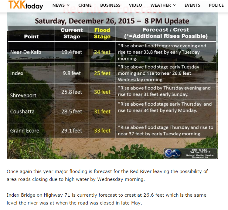
Major flooding once again on the Red River in NE Texas. River levels are predicted to rivals those of last spring's flood this week:

Image
0 likes   

Jarodm12
Category 1
Category 1
Posts: 337
Joined: Sat Jan 29, 2011 8:05 pm

Re: Texas Winter 2015-2016

#1213 Postby Jarodm12 » Sun Dec 27, 2015 4:23 pm

light snow being reported in Gainesville

http://forecast.weather.gov/MapClick.ph ... oBWrPkrK1t
0 likes   

User avatar
TheProfessor
Professional-Met
Professional-Met
Posts: 3506
Age: 28
Joined: Tue Dec 03, 2013 10:56 am
Location: Wichita, Kansas

#1214 Postby TheProfessor » Sun Dec 27, 2015 4:24 pm

Down to 37 at Roanoke Elementary, If you have a smart phone, Apple or Android, I would download the app called my radar, it's really cool you can get severe alerts like a NOAA Weather Radio with it and it has an animated temperature map and you can see that the freezing line is starting to move a bit faster now.
0 likes   
An alumnus of The Ohio State University.

Your local National Weather Service office is your best source for weather information.

JayDT
Category 1
Category 1
Posts: 354
Joined: Tue Dec 16, 2014 12:55 pm
Location: Dallas, Texas

#1215 Postby JayDT » Sun Dec 27, 2015 4:26 pm

I might be wrong but to me it looks like the 18z NAM is trending a little further south & east?
0 likes   

aggiecutter
Category 5
Category 5
Posts: 1753
Joined: Thu Oct 14, 2004 9:22 pm
Location: Texarkana

Re: Texas Winter 2015-2016

#1216 Postby aggiecutter » Sun Dec 27, 2015 4:32 pm

The Tornado threat in NE Texas is becoming serious:

Image
0 likes   

User avatar
JDawg512
Category 5
Category 5
Posts: 1077
Age: 45
Joined: Mon Aug 26, 2013 8:56 pm
Location: Austin
Contact:

Re:

#1217 Postby JDawg512 » Sun Dec 27, 2015 4:35 pm

TheProfessor wrote:Down to 37 at Roanoke Elementary, If you have a smart phone, Apple or Android, I would download the app called my radar, it's really cool you can get severe alerts like a NOAA Weather Radio with it and it has an animated temperature map and you can see that the freezing line is starting to move a bit faster now.


I have that app. It's a good app to have for sure.
0 likes   
Resident Rain Miser

I am a weather hobbyist living 3.5 miles south of Downtown Austin and in no way or fashion should anything I say concerning forecasts be taken seriously. Please check your local NWS for accurate weather forecasting and conditions.

User avatar
SouthernMet
Category 3
Category 3
Posts: 857
Joined: Sun Aug 29, 2010 8:23 pm
Location: fort worth, tx

Re: Texas Winter 2015-2016

#1218 Postby SouthernMet » Sun Dec 27, 2015 4:36 pm

Not trying to sound the alarms, but I think we may have a window of opportunity for snow, atleast west of a Denton, Fort Worth, Granbury line, after midnight - 6am, possibly lingering until 9am, depending on the exact track/speed.

Edit : 18z NAM shifts snow on east onto DFW.

Image


Image

When the system moves over us, just like we saw earlier in Del Rio, tx and just like we saw on christmas eve, the column will cool enough for snow to reach the surface. We are going to need to watch for wet bulbing and dynamic cooling tonight, starting at 10pm for western counties.
Last edited by SouthernMet on Sun Dec 27, 2015 4:49 pm, edited 2 times in total.
0 likes   
Nothing that SouthernMet posts, is an official forecast,nor does it reflect views of STORM2K.. SouthernMet is just adding to the great discussions on STORM2K.. Refer to NWS for official forecasts.

aggiecutter
Category 5
Category 5
Posts: 1753
Joined: Thu Oct 14, 2004 9:22 pm
Location: Texarkana

Re: Texas Winter 2015-2016

#1219 Postby aggiecutter » Sun Dec 27, 2015 4:37 pm

Confirmed Tornado damage in Dekalb, Texas per NBC 6 in Shreveport.
0 likes   

User avatar
TheProfessor
Professional-Met
Professional-Met
Posts: 3506
Age: 28
Joined: Tue Dec 03, 2013 10:56 am
Location: Wichita, Kansas

#1220 Postby TheProfessor » Sun Dec 27, 2015 4:39 pm

That's the first time the NAM has had snow reaching Denton County
0 likes   
An alumnus of The Ohio State University.

Your local National Weather Service office is your best source for weather information.


Return to “Winter Weather”

Who is online

Users browsing this forum: No registered users and 10 guests