Texas Winter 2016-2017
Moderator: S2k Moderators
Forum rules
 The posts in this forum are NOT official forecast and should not be used as such. They are just the opinion of the poster and may or may not be backed by sound meteorological data. They are NOT endorsed by any professional institution or STORM2K.

The posts in this forum are NOT official forecast and should not be used as such. They are just the opinion of the poster and may or may not be backed by sound meteorological data. They are NOT endorsed by any professional institution or STORM2K.

Re: Texas Winter 2016-2017
Orangewood, do you believe the pattern is setup for winter weather this early? Also, what are your thoughts on -epo and other stuff? Thanks. Kevin
0 likes
-
CaptinCrunch

- S2K Supporter

- Posts: 8779
- Age: 58
- Joined: Mon Nov 03, 2003 4:33 pm
- Location: Kennedale, TX (Tarrant Co.)
Re: Texas Winter 2016-2017
orangeblood wrote:Well here we go....a very active southern storm track upcoming over the next few weeks - first serious threat for winter weather in the 2016-17 season, middle of next week. GFS colder than both the Euro/CMC but all have the storm crossing the southern plains Wed/Thurs time frame

We saw a lot of this the last 2 winters, it's a pretty map, but unless it's 72 hours out, it's just a pretty map.
0 likes
-
orangeblood
- S2K Supporter
- Posts: 3895
- Joined: Tue Dec 15, 2009 6:14 pm
- Location: Fort Worth, TX
Re: Texas Winter 2016-2017
Golf7070 wrote:Orangewood, do you believe the pattern is setup for winter weather this early? Also, what are your thoughts on -epo and other stuff? Thanks. Kevin
- EPO is not quite there yet to deliver extreme cold but with the -AO/-NAO/-PNA suppressing the storm track across our part of the world, one of the systems could deepen enough to bring cold enough air down to the surface for frozen precip.
The blocking towards the pole this time of year is really promising for an active winter season across the US
0 likes
-
CaptinCrunch
- S2K Supporter
- Posts: 8779
- Age: 58
- Joined: Mon Nov 03, 2003 4:33 pm
- Location: Kennedale, TX (Tarrant Co.)
Re: Texas Winter 2016-2017
22 days into November and we are still in a warm pattern even though we are starting to see stronger cold fronts make it's way into NTX. We have only had 2 days in the month with a below average daily temp, and 10 of the first 22 days have averaged 10+ degrees above the daily avg. November is +7.0 above the monthly mean, and we are currently +.30 in monthly precip.
With 8 days left in the month temps are looking to hold at or just above average through the Holiday weekend then we may see the last 2 or 3 days of November drop to just below average. I don't see any freezing temps through the end of the month (29th & 30th could be close) so it looks like we may have to wait till December before the DFW metro area sees it's first official freeze of the season.
On a bright note I did ask Pete Delkus last night on his FB live feed about the 6z GFS from yesterday, he said he hasn't looked at any of the long range models but the GFS was the most unreliable of the models used (king EURO) and is usually only right about once a month....lol
OH, and I forgot to add that Delkus said, currently we are experiencing weak La Nina conditions, however there are signs that are pointing to a colder pattern change through at least the first half of December, and on average we experience about 33 freezes a year, but we could see a little more than that this winter.
Happy Thanksgiving Everyone!
Last edited by CaptinCrunch on Wed Nov 23, 2016 11:05 am, edited 1 time in total.
0 likes
-
ThunderSleetDreams

- S2K Supporter
- Posts: 1510
- Age: 43
- Joined: Tue Dec 20, 2011 4:42 pm
- Location: S of Weimar, TX
Re: Texas Winter 2016-2017
6z GFS... Hour 276 onward on the GFS brings 40s for highs into SE Texas and the mother load of Arctic Air entering the Northern Rockies at -20 to -30F
0 likes
#NeverSummer
I hibernate when it gets above 75 degrees!
I hibernate when it gets above 75 degrees!
-
CaptinCrunch
- S2K Supporter
- Posts: 8779
- Age: 58
- Joined: Mon Nov 03, 2003 4:33 pm
- Location: Kennedale, TX (Tarrant Co.)
Re: Texas Winter 2016-2017
ThunderSleetDreams wrote:6z GFS... Hour 276 onward on the GFS brings 40s for highs into SE Texas and the mother load of Arctic Air entering the Northern Rockies at -20 to -30F
I would look at the EURO for the same time period and place my bet there.
1 likes
-
ThunderSleetDreams
- S2K Supporter
- Posts: 1510
- Age: 43
- Joined: Tue Dec 20, 2011 4:42 pm
- Location: S of Weimar, TX
Re: Texas Winter 2016-2017
CaptinCrunch wrote:ThunderSleetDreams wrote:6z GFS... Hour 276 onward on the GFS brings 40s for highs into SE Texas and the mother load of Arctic Air entering the Northern Rockies at -20 to -30F
I would look at the EURO for the same time period and place my bet there.
Can you detail for me? I don't have access.
0 likes
#NeverSummer
I hibernate when it gets above 75 degrees!
I hibernate when it gets above 75 degrees!
-
ThunderSleetDreams
- S2K Supporter
- Posts: 1510
- Age: 43
- Joined: Tue Dec 20, 2011 4:42 pm
- Location: S of Weimar, TX

-
orangeblood
- S2K Supporter
- Posts: 3895
- Joined: Tue Dec 15, 2009 6:14 pm
- Location: Fort Worth, TX
Re: Texas Winter 2016-2017
Where is everyone ??? Next week should get much more interesting around here.....
12Z Euro southern plains winter storm for December 7-8th

12Z Euro southern plains winter storm for December 7-8th
0 likes
-
Portastorm

- Storm2k Moderator

- Posts: 9955
- Age: 63
- Joined: Fri Jul 11, 2003 9:16 am
- Location: Round Rock, TX
- Contact:
Re: Texas Winter 2016-2017
Everyone is still posting over in the Fall thread. We usually migrate over here on December 1. But yeah ... your image and associated items have been discussed greatly in the last week in that other thread.
0 likes
Any forecasts under my name are to be taken with a grain of salt. Get your best forecasts from the National Weather Service and National Hurricane Center.
-
Ralph's Weather
- S2K Supporter
- Posts: 3371
- Age: 38
- Joined: Fri Dec 13, 2013 11:55 am
- Location: Lindale, TX
- Contact:
Re: Texas Winter 2016-2017
Looks like winter will start off right with a cold and wet few days and dare I even mention that the system would need just a bit of extra something for flakes to mix in. While we entertain that system very cold air will build over western Canada. That Arctic air mass looks to move south for the second weekend of December and stick around for a while. Hope we can get some storms to pass through the cold air.
0 likes
Follow on Facebook at Ralph's Weather.
-
ThunderSleetDreams
- S2K Supporter
- Posts: 1510
- Age: 43
- Joined: Tue Dec 20, 2011 4:42 pm
- Location: S of Weimar, TX
Re: Texas Winter 2016-2017
New avatar test just in time for Winter!
1 likes
#NeverSummer
I hibernate when it gets above 75 degrees!
I hibernate when it gets above 75 degrees!
-
Ralph's Weather
- S2K Supporter
- Posts: 3371
- Age: 38
- Joined: Fri Dec 13, 2013 11:55 am
- Location: Lindale, TX
- Contact:
Re: Texas Winter 2016-2017
ThunderSleetDreams wrote:New avatar test just in time for Winter!
Awesome, now if only that pattern can set up in December.
0 likes
Follow on Facebook at Ralph's Weather.
-
srainhoutx

- S2K Supporter
- Posts: 6919
- Age: 68
- Joined: Sun Jan 14, 2007 11:34 am
- Location: Haywood County, NC
- Contact:
Re: Texas Winter 2016-2017
Confidence is slowly increasing regarding the upcoming weekend, but there remains some uncertainty as to how quickly the cut off upper low over Northern Mexico ejects East. The ECMWF and its ensemble members remain progressive or faster moving this cold core upper low out of Mexico into Texas. The UKMET has joined the GFS/Canada model solutions suggesting a meandering slow moving upper low over Northern Mexico/Southern Arizona and Southern New Mexico and finally moving into West Texas about 24 hours slower than the ECMWF schemes.
To further complicate the sensible weather forecast is the Coastal low/trough scenario depicted by the model solutions along the South Texas Coast moving NE toward the Upper Texas Coast Saturday night into Sunday, possibly extending into early Monday. Brisk chilly NE winds at the surface suggest colder temperatures in the mid to upper 40's inland with 50's near the Coast with over running precipitation increasing as the Coastal low/trough develops. There is growing concern for some elevated thunderstorms lending to the potential of a heavy rainfall event, depending on where the Coastal low/trough develops and just how quickly the cold core upper low ejects from Northern Mexico into Texas. To further complicate the sensible weather forecast is the possibility of some phasing with another storm system further North across the Great Plains which appears to have some very cold air associated with it.
Another feature to watch much further NW across Alaska and NW Canada is the arrival of the first Arctic Outbreak we have seen in a couple of years. The reliable computer models are suggesting 2 meter temperatures may plummet to near -50F with even some locations in Eastern Alaska and NW Canada approaching near -70F for overnight lows next Sunday into next Tuesday. Arctic air appears to be on the move South next week into the Rockies and the Great Plains. We will monitor that feature as it gets a bit closer.
For now, attention turns to the weekend and what appears to be a raw and wet pattern as Winter returns to Texas. Stay tuned!
EXTENDED FORECAST DISCUSSION
NWS WEATHER PREDICTION CENTER COLLEGE PARK MD
134 AM EST TUE NOV 29 2016
VALID 12Z FRI DEC 02 2016 - 12Z TUE DEC 06 2016
...INCREASING CONFIDENCE OF HEAVY RAINFALL THIS WEEKEND ACROSS THE
WESTERN/CENTRAL GULF COAST...
...MODEL EVALUATION/PREFERENCES...
THE MAJOR FORECAST CHALLENGE WILL BE THE EVOLUTION OF A FORECAST
CLOSED LOW OVER THE SOUTHWEST US THIS WEEKEND. A SHORTWAVE IS
FORECAST TO AMPLIFY AND FORM A CUTOFF LOW ON FRIDAY SOMEWHERE
ACROSS SOUTHERN AZ/NM OR NORTHERN MEXICO. SPREAD INCREASES
DRAMATICALLY WITH RESPECT TO THIS FEATURE AFTER THE CUTOFF FORMS,
WITH THE 12Z ECMWF/UKMET SUGGESTING A MORE PROGRESSIVE EASTWARD
MOTION...WHICH PROVIDES A SECOND RUN OF A FASTER SOLUTION IN BOTH
MODELS.
THE 18Z GFS/12Z CMC AS WELL AS THE 18Z GEFS MEAN/12Z CMCE MEAN ALL
SUGGEST A MUCH SLOWER PROGRESSION, KEEPING THE CUTOFF ACROSS
NORTHERN MEXICO OR WEST TX THROUGH SUNDAY. THE GFS HAS SHOWN A
MODERATE TO HIGH LEVEL OF RUN-TO-RUN CONSISTENCY WITH RESPECT TO
THIS SLOWER PROGRESSION OF THE CUTOFF. THERE IS GOOD AGREEMENT
AMONG THE GFS AND ITS ENSEMBLE MEAN...AS THERE IS AMONG THE ECMWF
AND ITS ENSEMBLE MEAN...SO ITS HARD TO IDENTIFY AN INTERMEDIATE
SOLUTION (I.E. BLENDING SUCH DISPARATE FORECASTS WOULD LOOK
UNREALISTIC IN IDENTIFYING THE LOWS AND FRONTS).
A BLEND OF THE 12Z ECMWF ENSEMBLE MEAN AND 12Z OPERATIONAL ECMWF
WAS USED...WITH MORE WEIGHTING TOWARDS THE MEAN SOLUTION GIVEN THE
LARGE ENVELOPE OF POSSIBILITIES.
SUPPORT WAS GIVEN BY RUN TO RUN CONTINUITY IN THE ECMWF FROM LAST
NIGHT IN MOVING THE SOUTHWEST CLOSED LOW EAST FASTER, PLUS THE 12Z
UKMET 500 MB WAVE PATTERN SHOWING ABOVE AVERAGE AGREEMENT WITH THE
ECMWF IN PHASING THE SOUTHERN STREAM ENERGY WITH THE NORTHERN
STREAM WAVE CROSSING FROM THE PLAINS AND UPPER MS VALLEY. FINALLY
THE VAST MAJORITY OF ECMWF ENSEMBLE MEMBERS HAVE THE MORE
PROGRESSIVE CLOSED LOW/TROUGH FORECAST. THE 00Z UKMET SLOWED DOWN
THE PROGRESSION OF THE CLOSED LOW...AND CLUSTERS WELL NOW WITH THE
00Z GFS..SO CONFIDENCE IN ANY ONE SOLUTION REMAINS LOW.
IN THE NORTHEAST...THE MODELS ARE IN GENERALLY GOOD AGREEMENT ON A
CUTOFF LOW CENTERED OVER SOUTHEASTERN ONTARIO ON DAY 3 (FRI 02
DEC), WHICH WILL BE IN THE PROCESS OF OPENING INTO A SHORTWAVE AS
IT BEGINS TO MOVE MORE QUICKLY EAST ACROSS THE NORTHEAST ON FRI.
THE ASSOCIATED SFC LOW PRESSURE SYSTEM WILL MOVE QUICKLY EAST AWAY
FROM NEW ENGLAND ON FRI.
OUT WEST..THE MEAN EAST PACIFIC TROUGH DRIFTS EAST WITH
TIME...WITH NEGATIVE HEIGHT ANOMALIES DEVELOPING AS THE TROUGH
CROSSES THE GREAT BASIN EARLY NEXT WEEK. AMPLIFICATION IS EXPECTED
DOWN STREAM FROM THE AMPLIFYING NORTHEAST PACIFIC RIDGE BY THE
MIDDLE OF NEXT WEEK.
...WEATHER HIGHLIGHTS/THREATS...
THERE IS POTENTIAL FOR HEAVY RAINFALL THIS WEEKEND ACROSS PORTIONS
OF THE UPPER TEXAS AND LA GULF COASTS...WITH STRONG MOISTURE
INFLUXES AND INCREASES IN AVAILABLE MOISTURE ALONG WITH LIFT OVER
A FRONTAL ZONE IN THE AREA. THE SLOWER GFS/CANADIAN GLOBAL CLOSED
LOW PROGRESSIONS WOULD DELAY THE TIMING. THERE IS POTENTIAL FOR
WIDESPREAD RAIN ACROSS THE PARCHED SOUTHEAST ONCE THE WAVE CROSSES
THE REGION.
WITH THE FRONTAL WAVE IN NORTHERN NEW ENGLAND...SNOW IS EXPECTED
IN NORTHERN MAINE THU AND TAPERING AS THE WAVE DEPARTS FRI.
EXPECT VALLEY RAIN AND MOUNTAIN SNOW TO SPREAD INTO THE PAC NW BY
SATURDAY AS A PACIFIC SFC FRONT MOVES INLAND...WITH SNOW
CONTINUING IN THE PAC NW AND NORTHERN ROCKIES SUN AS MOIST ONSHORE
FLOW CONTINUES UNDERNEATH A STRONG WEST-EAST UPPER LEVEL JET.
ANOMALOUSLY LOW HEIGHTS WILL PROMOTE BELOW AVERAGE TEMPERATURES
ACROSS MUCH OF THE SOUTHERN PLAINS SAT INTO SUN WITH THE
COMBINATION OF CLOUDS AND COLD ADVECTION.
LIKEWISE...COLD ANOMALIES DEVELOP WITH LOWERING HEIGHTS AND THE
ARRIVAL OF PRECIP OVER THE WEEKEND.
HIGH PRESSURE BUILDING DOWN THE LEE SIDE OF THE CANADIAN ROCKIES
SUPPORTS THE FIRST ARCTIC OUTBREAK OF THE SEASON DEVELOPING AND
MOVING SOUTH INTO MT AROUND THE MIDDLE OF NEXT WEEK...SO TEMPS
COULD DROP TO DOUBLE DIGITS BELOW NORMAL ON TUE 06 DEC IN MT IF
THIS OCCURS. LOWERING HEIGHTS IN THE GREAT BASIN AND INTERMOUNTAIN
WEST SUPPORTS TEMPS DROPPING BELOW NORMAL ACROSS ID/UT/WY AS WELL
BY TUE 06 DEC.
PETERSEN
2 likes
Carla/Alicia/Jerry(In The Eye)/Michelle/Charley/Ivan/Dennis/Katrina/Rita/Wilma/Ike/Harvey
Member: National Weather Association
Wx Infinity Forums
http://wxinfinity.com/index.php
Facebook.com/WeatherInfinity
Twitter @WeatherInfinity
Member: National Weather Association
Wx Infinity Forums
http://wxinfinity.com/index.php
Facebook.com/WeatherInfinity
Twitter @WeatherInfinity
-
vbhoutex

- Storm2k Executive

- Posts: 29147
- Age: 74
- Joined: Wed Oct 09, 2002 11:31 pm
- Location: Cypress, TX
- Contact:
Re: Texas Winter 2016-2017
Of all weekends for this possibly happen ugh!! We are supposed to go downtown and take our granddaughter to see the Nutcracker Ballet. Hopefully we can get to the theater from underground parking and stay dry. I was hoping this was being overhyped and would be a minor event. Doesn't look that way now.
0 likes
Skywarn, C.E.R.T.
Please click below to donate to STORM2K to help with the expenses of keeping the site going:

Please click below to donate to STORM2K to help with the expenses of keeping the site going:
-
Lagreeneyes03
- Category 2

- Posts: 610
- Joined: Mon Dec 09, 2013 10:53 am
- Location: Luxurious Lake Grapevine
Re: Texas Winter 2016-2017
vbhoutex wrote:Of all weekends for this possibly happen ugh!! We are supposed to go downtown and take our granddaughter to see the Nutcracker Ballet. Hopefully we can get to the theater from underground parking and stay dry. I was hoping this was being overhyped and would be a minor event. Doesn't look that way now.
Definitely worth it to Valet.
0 likes
I'm a Princess, not a forecaster.
-
vbhoutex
- Storm2k Executive
- Posts: 29147
- Age: 74
- Joined: Wed Oct 09, 2002 11:31 pm
- Location: Cypress, TX
- Contact:
Re: Texas Winter 2016-2017
Thanks for the reminder!!Lagreeneyes03 wrote:vbhoutex wrote:Of all weekends for this possibly happen ugh!! We are supposed to go downtown and take our granddaughter to see the Nutcracker Ballet. Hopefully we can get to the theater from underground parking and stay dry. I was hoping this was being overhyped and would be a minor event. Doesn't look that way now.
Definitely worth it to Valet.
0 likes
Skywarn, C.E.R.T.
Please click below to donate to STORM2K to help with the expenses of keeping the site going:
Please click below to donate to STORM2K to help with the expenses of keeping the site going:
-
ThunderSleetDreams
- S2K Supporter
- Posts: 1510
- Age: 43
- Joined: Tue Dec 20, 2011 4:42 pm
- Location: S of Weimar, TX
Re: Texas Winter 2016-2017
When you know the Winter thread will really get poppin tomorrow.
https://twitter.com/woridstarfights/status/790250432299986944
https://twitter.com/woridstarfights/status/790250432299986944
0 likes
#NeverSummer
I hibernate when it gets above 75 degrees!
I hibernate when it gets above 75 degrees!
-
srainhoutx
- S2K Supporter
- Posts: 6919
- Age: 68
- Joined: Sun Jan 14, 2007 11:34 am
- Location: Haywood County, NC
- Contact:
Re: Texas Winter 2016-2017
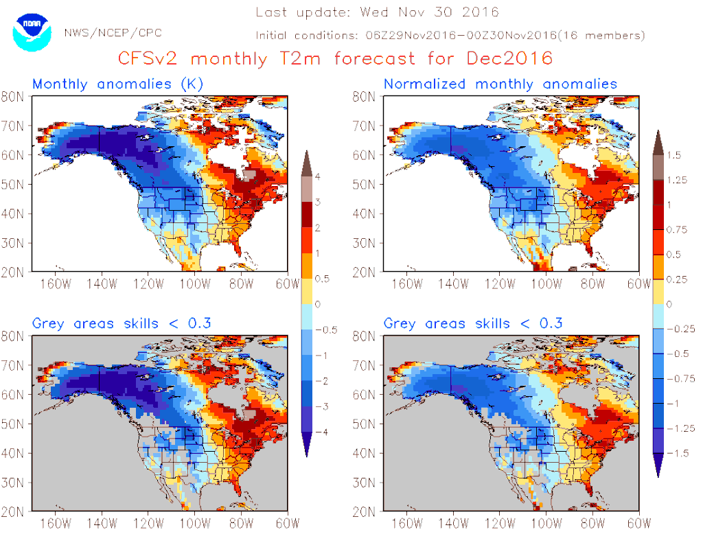
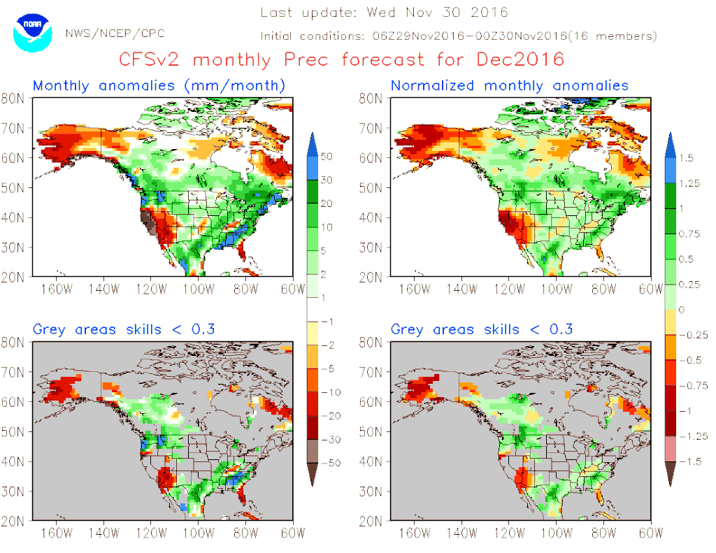
Some have been asking what the mid December toward Christmas timeframe may offer. The Updated CFSv2 Monthly climate model suggests colder than normal temperatures and slightly above normal precipitation chances. Typically I have noticed a bit of a warm bias for this particular Long Range Ensemble Model over the years. That said look how cold our source Regions of Eastern Alaska and NW Canada throughout the month.
0 likes
Carla/Alicia/Jerry(In The Eye)/Michelle/Charley/Ivan/Dennis/Katrina/Rita/Wilma/Ike/Harvey
Member: National Weather Association
Wx Infinity Forums
http://wxinfinity.com/index.php
Facebook.com/WeatherInfinity
Twitter @WeatherInfinity
Member: National Weather Association
Wx Infinity Forums
http://wxinfinity.com/index.php
Facebook.com/WeatherInfinity
Twitter @WeatherInfinity
-
Ralph's Weather
- S2K Supporter
- Posts: 3371
- Age: 38
- Joined: Fri Dec 13, 2013 11:55 am
- Location: Lindale, TX
- Contact:
Re: Texas Winter 2016-2017
Winter looks to start off with flooding in E TX and possibly heavy snow over the Panhandle if the moisture makes it that far north. An Arctic front is still solidly on the table for late next week with plenty more to tap by future fronts.
0 likes
Follow on Facebook at Ralph's Weather.
Who is online
Users browsing this forum: vbhoutex and 50 guests