

+TNH (Big -EPO) typically leads to big arctic outbreaks due to expansive cold pool and favorable Pacific.


https://www.cpc.ncep.noaa.gov/data/teledoc/tnh.shtml

Moderator: S2k Moderators
 The posts in this forum are NOT official forecast and should not be used as such. They are just the opinion of the poster and may or may not be backed by sound meteorological data. They are NOT endorsed by any professional institution or STORM2K.


Harp.1 wrote:It appears things are looking up


Harp.1 wrote:It appears things are looking up

TeamPlayersBlue wrote:I think the key is getting some sort of MJO movement. The MJO will make things much more predictable. If the models see the MJO popping in a relatively short period of time, models can latch onto other dynamics much easier.
txtwister78 wrote:TeamPlayersBlue wrote:I think the key is getting some sort of MJO movement. The MJO will make things much more predictable. If the models see the MJO popping in a relatively short period of time, models can latch onto other dynamics much easier.
That is definitely a better signal than what you had just a few days ago there but still some differences in terms of timing/progression but nonetheless at least you have some sense of where this "could be" headed going forward

Ntxw wrote:Harp.1 wrote:It appears things are looking up
We're not there yet, much of this is still 2 weeks out. But in a week would like to see pieces moving and knock down these above normal temps.
Ntxw wrote:It's also not just winter aspects, though that is one side effect of winter lovers want, but also out in the Pacific Ocean there is a potential WWB or westerly wind burst that's going to be the driver for this upcoming MJO impulse. Ramifications go beyond just the next month as it is the initial building block for a possible big El niño this coming year. La niña is quickly collapsing.
ENSO Thread
TeamPlayersBlue wrote:1072 MB high in La La land of the GFS. A few runs in a row it has showed a goliath block over the Bering Sea.
Gotwood wrote:I am getting desperate for snow. Wish the storm in the panhandle was on Saturday I would probably make the drive. I hope we get something this winter I can’t imagine having a winter with no trace of winter precipitation.
orangeblood wrote:TeamPlayersBlue wrote:1072 MB high in La La land of the GFS. A few runs in a row it has showed a goliath block over the Bering Sea.
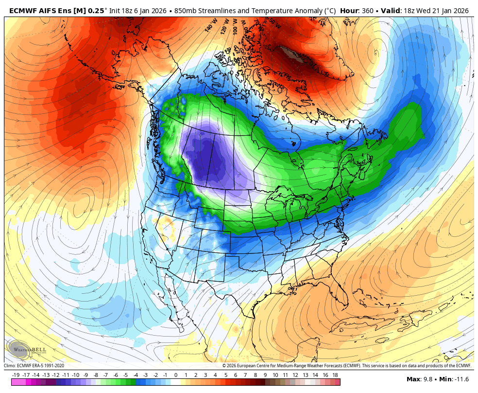
When you start seeing these 850 anomalies showing up on an
ENS Mean, buckle up!!!
https://images.weatherbell.com/model/ecmwf-aifs-ensemble-avg/namer/t850_anom_stream/1767722400/1769018400-J36TNJGIEtI.png
Golfisnoteasy75 wrote:orangeblood wrote:TeamPlayersBlue wrote:1072 MB high in La La land of the GFS. A few runs in a row it has showed a goliath block over the Bering Sea.
When you start seeing these 850 anomalies showing up on an
ENS Mean, buckle up!!!
https://images.weatherbell.com/model/ecmwf-aifs-ensemble-avg/namer/t850_anom_stream/1767722400/1769018400-J36TNJGIEtI.png
Do you like the new ai models? Or do you think they over exaggerated a pattern?
Users browsing this forum: No registered users and 45 guests


