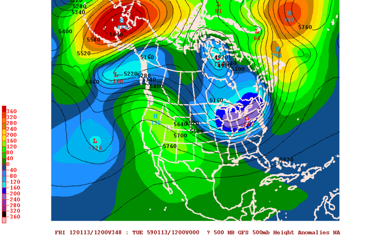
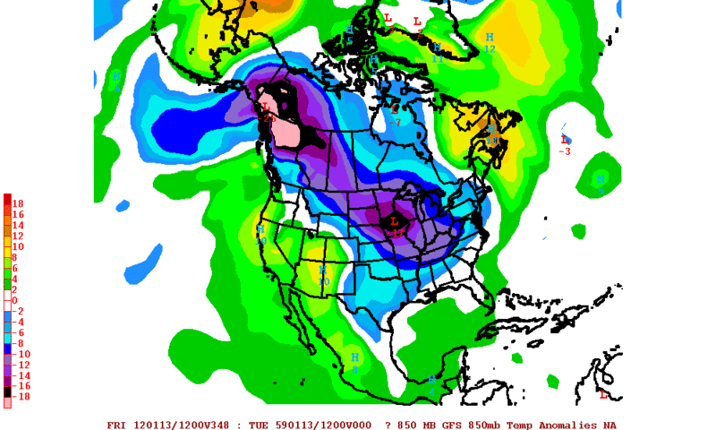
Texas Winter 2011-2012...

Winter Weather Discussion

Moderator: S2k Moderators

Forum rules

The posts in this forum are NOT official forecast and should not be used as such. They are just the opinion of the poster and may or may not be backed by sound meteorological data. They are NOT endorsed by any professional institution or STORM2K.

Help Support Storm2K
Message
Author
User avatar
Ntxw
Storm2k Moderator
Storm2k Moderator
Posts: 22789
Joined: Wed Oct 21, 2009 6:34 pm
Location: DFW, Texas

#1541 Postby Ntxw » Thu Dec 29, 2011 11:36 pm

Texas Snowman wrote:Larry Cosgrove: "...but yet another surge of colder values looks to reach Texas by the end of next week."

http://www.examiner.com/weather-in-hous ... 12-30-2011


Lol out of the blues GFS isn't as tranquil for Texas. Not cold of sorts, but a cutoff low could bring some rain underneath the ridge in east Texas, then late next week a colder storm will follow if 0z is to be believed.

Image

Uploaded with ImageShack.us
0 likes   
The above post and any post by Ntxw is NOT an official forecast and should not be used as such. It is just the opinion of the poster and may or may not be backed by sound meteorological data. It is NOT endorsed by any professional institution including Storm2k. For official information, please refer to NWS products.

  Help support Storm2K!
Help Support Storm2K

User avatar
hriverajr
Professional-Met
Professional-Met
Posts: 786
Joined: Tue Jul 19, 2005 12:16 am

Re: Texas Winter 2011-2012...

#1542 Postby hriverajr » Fri Dec 30, 2011 12:58 am

orangeblood wrote:
hriverajr wrote:
wxman57 wrote:And, by the way, my post above was merely my observations of what was depicted by the European model, not necessarily my forecast of what was going to happen. However, one thing appears certain. There isn't much cold air currently in Canada and there isn't much snow cover across the U.S., which means we're not likely to see much cold air down south through at least the 2nd week of January.


Yep its only common sense, you don't even have to look at the models. You have to have the cold air really build up. Takes time at least 5-7 days. Then it has to be dislodged and move south another 3-7 days. So at a minimum that is over a week. Right now we don't even have any indications of that happening short term. i would say we are safe from significant cold air intrusions (Texas) at least through the 7th of January and most likely longer.


I'm going to have to respectfully disagree with you on this....cold air building in Canada isn't the only way we can get cold air intrusions down here. One way is from Alaska...there is plenty of cold air building in Alaska and the Bering Straight right now (25-30 below normal in some places) and if that Alaskan Vortex retrogrades to the west any, then look out in the lower 48 because some of that Alaskan cold has a chance to make it this way. All you need is help from the polar jet to break off a piece of that cold high pressure, bringing it quickly through Canada directly down the spine of the Rockies and into the southern plains (sometimes making it down here in less than 3 days). And sure enough that is exactly what the 18Z GFS is showing for next weekend.

There is plenty of cold air close enough to tap into and if the polar jet reconfigures itself just right then look out below. Now, it'll be hard to get sustained cold around here (we need the PV to entrain itself north of the Great Lakes for that) but it can get quite cold for a couple of days with a shot like the one I'm describing above. This is just something I've noticed looking back at past Upper Level and surface maps over the years.


I guess that could happen and would most likely be transient. Just in all my years I think that type of scenario may have happened once or twice. Yes it is possible. Then again just about anything is possible in the weather. I myself would prefer cold as well. Usually though you do have some lead time before a major arctic outbreak. I think it will get chilly and windy..but not obnoxiously cold for at least a week.

In the interest of transparency. I used to work in the meteorological field, did a TV stint as well. Currently I am an Instructor of Computer Science and am on vacation. However I still am a big weather nerd so to speak.
Last edited by hriverajr on Fri Dec 30, 2011 1:02 am, edited 1 time in total.
0 likes   

User avatar
Rgv20
S2K Supporter
S2K Supporter
Posts: 2466
Age: 39
Joined: Wed Jan 05, 2011 5:42 pm
Location: Edinburg/McAllen Tx

#1543 Postby Rgv20 » Fri Dec 30, 2011 1:01 am

The GFS is still entertaining the idea of some pretty cold air building up in Alaska and NW Canada in the long range (10+days out). Took a look at the 12zECMWF Ensemble Control Run (Goes out to 15 days) and it is too showing 850mb temperatures in the -25 to -30C in the same regions as the GFS.


Take a look at the 0zGFS forecast 500mb Heights Anomalies over Alaska on Jan 12!! :eek: The dark red shading would indicate a some crazy positive 500mb anomalies meaning any cold air up there should start marching to the US.
Image


The GFS is also forecasting some pretty impressive negative 850mb Temperatures Anomalies over NW Canada!
Image
0 likes   
The following post is NOT an official forecast and should not be used as such. It is just the opinion of the poster and may or may not be backed by sound meteorological data. It is NOT endorsed by any professional institution including storm2k.org For Official Information please refer to the NHC and NWS products.

User avatar
somethingfunny
ChatStaff
ChatStaff
Posts: 3926
Age: 37
Joined: Thu May 31, 2007 10:30 pm
Location: McKinney, Texas

#1544 Postby somethingfunny » Fri Dec 30, 2011 3:42 am

We've all seen the models wish-wash around on these arctic outbreaks for several weeks over the past few years. It'll come down, eventually. Early February is my guess. :D
0 likes   
I am not a meteorologist, and any posts made by me are not official forecasts or to be interpreted as being intelligent. These posts are just my opinions and are probably silly opinions.

User avatar
hriverajr
Professional-Met
Professional-Met
Posts: 786
Joined: Tue Jul 19, 2005 12:16 am

Re: Texas Winter 2011-2012...

#1545 Postby hriverajr » Fri Dec 30, 2011 11:10 am

Hmm.... no posts.. Have not even looked at the models, but I can imagine ;) hehe
0 likes   

User avatar
wxman57
Moderator-Pro Met
Moderator-Pro Met
Posts: 22984
Age: 67
Joined: Sat Jun 21, 2003 8:06 pm
Location: Houston, TX (southwest)

Re: Texas Winter 2011-2012...

#1546 Postby wxman57 » Fri Dec 30, 2011 11:27 am

Apparently, a possible light freeze next Tuesday across the Texas panhandle and NE Texas isn't too exciting for most here.

Unfortunately (for me), the 12Z GFS continues to insist upon a buildup of cold air (15-20F below normal) in western Canada between the 10th and 14th of January. This cold air could reach the Gulf coast the 3rd week of the month. However, the 12Z GFS keeps the cold air to our north through 384 hrs.
0 likes   

User avatar
iorange55
Category 5
Category 5
Posts: 2388
Joined: Thu Nov 13, 2008 9:47 pm
Location: Big D

Re: Texas Winter 2011-2012...

#1547 Postby iorange55 » Fri Dec 30, 2011 11:54 am

Yay! Wxman finally mentions some cold weather coming down the pipe. I just hope we get a nice storm to go along with it, I don't want to waste the cold this year. There doesn't seem to be much of it.
0 likes   

Palmer divide shadow
Tropical Depression
Tropical Depression
Posts: 54
Joined: Thu Dec 29, 2011 11:15 am
Location: Monument Colorado,but from Sugarland tx

Re: Texas Winter 2011-2012...

#1548 Postby Palmer divide shadow » Fri Dec 30, 2011 11:58 am

A light freeze in the panhandle is shorts weather lol
0 likes   

User avatar
Ptarmigan
Category 5
Category 5
Posts: 5316
Joined: Wed Aug 16, 2006 9:06 pm

Re: Texas Winter 2011-2012...

#1549 Postby Ptarmigan » Fri Dec 30, 2011 12:03 pm

wxman57 wrote:
Depends on what data you're looking at. Taking a look at the European forecasts, both the NAO and AO remain positive through the 13th. No prediction of either going negative. Stratospheric warming fades away by mid January (GFS). GFS operational does indicate temperatures across western Canada finally cooling down to well below normal by the 13th. But the GFS has been quite poor in its long-range predictions as well. GFS ensembles have the air 5-10F above normal in western Canada the 2nd week of January where the operational run has temps 20-30F below normal. In fact, none of the models has done really well in the long-term with the current pattern.

And, by the way, my post above was merely my observations of what was depicted by the European model, not necessarily my forecast of what was going to happen. However, one thing appears certain. There isn't much cold air currently in Canada and there isn't much snow cover across the U.S., which means we're not likely to see much cold air down south through at least the 2nd week of January.


NAO and AO are hard to predict and can change quickly. Most of the cold air is over Alaska. Also, there is the PNA.

The February 1989 Freeze is interesting that the NAO and AO was positive, while PNA was negative. It was also in a La Nina, like the January/February 1951 Freeze. The 1951 was a hard and deep freeze. The 1989 freeze was a shallow freeze.

1951
ENSO = La Nina
NAO = Positive
AO = Negative
PNA = Negative

1989
ENSO = La Nina
NAO = Positive
AO = Positive
PNA = Negative
0 likes   

Snowshoe
Tropical Low
Tropical Low
Posts: 48
Joined: Sun Dec 04, 2011 4:17 pm
Location: Carrollton, Texas

#1550 Postby Snowshoe » Fri Dec 30, 2011 3:53 pm

Gorgeous outside and don't mind it, but hoping for some cold and snow this winter! Our hope isn't gone, winter has barely begun!
0 likes   

User avatar
Rgv20
S2K Supporter
S2K Supporter
Posts: 2466
Age: 39
Joined: Wed Jan 05, 2011 5:42 pm
Location: Edinburg/McAllen Tx

#1551 Postby Rgv20 » Fri Dec 30, 2011 8:20 pm

The 500mb pattern for mid January is shaping up like the one we had this last November. That 500mb ridge north of Hawaii would force a trough south meaning unsettled weather until the western part of the US. This pattern also allows for some cold air to build up north but have to wait and see if it decides to head south. The latest 12zECMWF Ensemble Control run keeps the cold air (-25 to -30C 850mb Temps) bottled up in NW Canada thru 360hrs.


CFS Weekly 500mb Anomaly forecast Jan13-Jan19 2012
Image


November 1 thru the 15th.
Image
0 likes   
The following post is NOT an official forecast and should not be used as such. It is just the opinion of the poster and may or may not be backed by sound meteorological data. It is NOT endorsed by any professional institution including storm2k.org For Official Information please refer to the NHC and NWS products.

User avatar
Texas Snowman
Storm2k Moderator
Storm2k Moderator
Posts: 6179
Joined: Fri Jan 25, 2008 11:29 am
Location: Denison, Texas

#1552 Postby Texas Snowman » Fri Dec 30, 2011 11:55 pm

Interesting tweet from WFAA-TV:

"@wfaaweathertoo: The data for the second week of January still suggest a significant storm forming, but details remain a little fuzzy. Stay tuned... -sm"
0 likes   
The above post and any post by Texas Snowman is NOT an official forecast and should not be used as such. It is just the opinion of the poster and may or may not be backed by sound meteorological data. It is NOT endorsed by any professional institution including storm2k.org. For official information, please refer to NWS products.

User avatar
iorange55
Category 5
Category 5
Posts: 2388
Joined: Thu Nov 13, 2008 9:47 pm
Location: Big D

Re: Texas Winter 2011-2012...

#1553 Postby iorange55 » Sat Dec 31, 2011 12:56 pm

GFS still looks interesting for the middle of January! Got a good feeling things will "heat up" in a week or two.
0 likes   

User avatar
Ntxw
Storm2k Moderator
Storm2k Moderator
Posts: 22789
Joined: Wed Oct 21, 2009 6:34 pm
Location: DFW, Texas

Re: Texas Winter 2011-2012...

#1554 Postby Ntxw » Sat Dec 31, 2011 1:26 pm

iorange55 wrote:GFS still looks interesting for the middle of January! Got a good feeling things will "heat up" in a week or two.


I'm usually not a fan of that range for GFS but I guess it's been consistent enough with Alaskan ridging to think about. And it's moving it up the time frame as each run progresses which is usually a good sign. We'll be in Euro long range mode soon to compare! One thing is for sure, both models depict the coldest air in the northern hemisphere to be in North America so all we really need is the right pattern to slide it down!

Canadian is latching onto the late week pattern change with a great basin system. It may not be of immediate impact to us but sets stage for maybe a reconfiguration of the 500mb flow!
0 likes   
The above post and any post by Ntxw is NOT an official forecast and should not be used as such. It is just the opinion of the poster and may or may not be backed by sound meteorological data. It is NOT endorsed by any professional institution including Storm2k. For official information, please refer to NWS products.


  Help support Storm2K!

Help Support Storm2K


aggiecutter
Category 5
Category 5
Posts: 1753
Joined: Thu Oct 14, 2004 9:22 pm
Location: Texarkana

Re: Texas Winter 2011-2012...

#1555 Postby aggiecutter » Sat Dec 31, 2011 4:45 pm

After doing some research and reading some of the forecast of respected long range forecasters, it has become apparent to me the MJO is one of the key drivers of weather patterns across North America. Even after the AO-NOA turned positive in the middle of January last year, the southern plains continued to see winter weather and cold into the early part of February. During that time, the MJO was in a favorable 8-1-2 phase for cold weather for the eastern 2/3rds of the country, see map below.

So far, in the late fall-winter of 2011, the MJO has mostly been in phase 5-6, which is very favorable for warm weather in the eastern 2/3rds of the country. As one can see from the map posted below, the chances for any sustained cold east of the Rockies is unlikely until the MJO moves into the 8-1-2-3 phases.

MJO JFM composites:
http://www.cpc.ncep.noaa.gov/products/p ... _image.png

Currently, the MJO is in phase 5-6 and is forecast to head toward phase 7 by the Ensembles. The forecast period is December 25th through January the 9th.
http://www.cpc.ncep.noaa.gov/products/p ... update.pdf

The EURO ensembles forecast the MJO to go through phase 6-7 and back to 5 by January 14th.
http://www.cpc.ncep.noaa.gov/products/p ... f_wh.shtml.

Until the MJO gets to phases 8-1-2-3, I wouldn't get my hopes up for any sustained cold weather in the southern plains and Texas. There are varying opinions among respected long range forecasters as to if the MJO will reach phases 8-1-2-3 by mid to late January. On the bright side, phase 5 does favor wet weather in the southern plains.

The preceding post is NOT an official forecast and should not be used as such. It is just the opinion of the poster and may or may not be backed by sound meteorological data. It is NOT endorsed by any professional institution including storm2k.org. For official information, please refer to NWS products.
0 likes   

weatherdude1108
Category 5
Category 5
Posts: 4228
Joined: Tue Dec 13, 2011 1:04 pm
Location: Northwest Austin/Cedar Park, TX

Re: Re:

#1556 Postby weatherdude1108 » Sat Dec 31, 2011 6:42 pm

Ntxw wrote:
Portastorm wrote:The recent chatter online suggests that the polar vortex may be getting displaced from where it has set up its location. When the polar vortex breaks down, per se, it is usually accompanied by sudden stratospheric warming (SSW) which altogether can create a major turn to bitter cold for the continental US.

Here is a link to a decent article on the subject:

http://www.aer.com/science-research/climate-weather/climate-dynamics/polar-vortex-impact-winter-weather


To add, SSW is not the only mechanism that can displace the PV. Tropical forcing (MJO) can too as well. Many times we focus on SSW as a precursor to cold outbreaks but it can also come from other places as well not involving the stratosphere! :wink:


Thank you all for the link and info.! It's more clear to me now. Temps 12 to 17 degrees above normal. Yeah, back to the textbook "warm and dry" La Nina. :cry: Lots of people out and about jogging/biking/leaf cleaning, etc. So not all bad. :wink: I want snow though. :froze:
0 likes   
The preceding post is NOT an official forecast, and should not be used as such. It is only the opinion of the poster and may or may not be backed by sound meteorological data. It is NOT endorsed by any professional institution including storm2k.org. For Official Information please refer to the NHC and NWS products.

weatherdude1108
Category 5
Category 5
Posts: 4228
Joined: Tue Dec 13, 2011 1:04 pm
Location: Northwest Austin/Cedar Park, TX

Re: Re:

#1557 Postby weatherdude1108 » Sat Dec 31, 2011 6:51 pm

weatherdude1108 wrote:
Ntxw wrote:
Portastorm wrote:The recent chatter online suggests that the polar vortex may be getting displaced from where it has set up its location. When the polar vortex breaks down, per se, it is usually accompanied by sudden stratospheric warming (SSW) which altogether can create a major turn to bitter cold for the continental US.

Here is a link to a decent article on the subject:

http://www.aer.com/science-research/climate-weather/climate-dynamics/polar-vortex-impact-winter-weather


To add, SSW is not the only mechanism that can displace the PV. Tropical forcing (MJO) can too as well. Many times we focus on SSW as a precursor to cold outbreaks but it can also come from other places as well not involving the stratosphere! :wink:


Thank you all for the link and info.! It's more clear to me now. Temps 12 to 17 degrees above
normal. Yeah, back to the textbook "warm and dry" La Nina. :cry: Lots of people out and about
jogging/biking/leaf cleaning, etc. So not all bad. :wink: I want snow though. :froze:


Forgot to add the discussion:

AREA FORECAST DISCUSSION
NATIONAL WEATHER SERVICE AUSTIN/SAN ANTONIO TX
300 PM CST SAT DEC 31 2011

.DISCUSSION...
TEMPERATURES ARE CURRENTLY SOARING TO 12-17 DEGREES ABOVE NORMAL
AND TODAY`S HIGHS WILL END UP 1-2 DEGREES GREATER THAN
YESTERDAY`S. THE COLD FRONT IS TAKING SHAPE OVER THE TX/OK
PANHANDLES AND IS STILL ON TRACK TO PUSH THROUGH LATE TONIGHT...
OR PRIOR TO SUNRISE NEW YEAR`S DAY. MOISTURE ADVECTION IN THE
LOWER BOUNDARY LAYER AHEAD OF THE FRONT WILL LEAD TO THE
REFORMATION OF FOG OVER THE COASTAL PRAIRIES...WITH AN ONSET AROUND
06Z...THEN DISSIPATING QUICKLY WITH FROPA BETWEEN 09-12Z. FOG IS
NOT ANTICIPATED TO AFFECT THE AUSTIN SAN ANTONIO CORRIDOR TONIGHT.
COLD AIR ADVECTION WILL NOT BE NOTABLY STRONG BEHIND THE FRONT AND
WINDS WILL BE UP...SO LOWS TOMORROW MORNING WILL LIKELY BE ABOVE
MOS AND CLOSER TO THE RAW MODEL NUMBERS. FULL SUN AND LIMITED COLD
AIR ADVECTION WILL ALLOW TEMPERATURES TO CLIMB UP INTO THE 60S ON
NEW YEAR`S DAY.

EXPECT COLD CONDITIONS SUNDAY NIGHT INTO TUESDAY MORNING WITH
TEMPERATURES BELOW NORMAL. TUESDAY MORNING WILL BE THE COLDEST OF
THE NEXT 7 DAYS...WITH A HARD FREEZE FORECAST ACROSS MUCH OF THE
CWFA.
0 likes   
The preceding post is NOT an official forecast, and should not be used as such. It is only the opinion of the poster and may or may not be backed by sound meteorological data. It is NOT endorsed by any professional institution including storm2k.org. For Official Information please refer to the NHC and NWS products.

Turtle
Category 1
Category 1
Posts: 285
Joined: Wed Jan 20, 2010 9:02 pm
Location: East Texas

#1558 Postby Turtle » Sun Jan 01, 2012 1:08 am

The 00z GFS looks amazing at 350+ hours. Good 3"+ of snow across the central and upper half of Texas.
0 likes   

User avatar
Rgv20
S2K Supporter
S2K Supporter
Posts: 2466
Age: 39
Joined: Wed Jan 05, 2011 5:42 pm
Location: Edinburg/McAllen Tx

#1559 Postby Rgv20 » Sun Jan 01, 2012 3:06 am

:uarrow: To add to your post Turtle, the GFS has been consisting on building up some pretty cold air in NW Canada around Jan 10th onward. The GFS and its Ensembles also forecast the AO to turn Negative in around 10 days or so. Perhaps Texas could be looking at some winter fun after the 15th??

On a shorter term forecast if you want to call it that.....The Texas Panhandle has a chance of Snow next Sunday (Jan 12) and if you believe tonight's 0zECMWF West Texas is going to be a winter wonderland early next week..Even Austin gets into the Snow Action :wink:


0zGFS AO Forecast
Image


0zGFS Ensembles AO Forecast
Image
0 likes   
The following post is NOT an official forecast and should not be used as such. It is just the opinion of the poster and may or may not be backed by sound meteorological data. It is NOT endorsed by any professional institution including storm2k.org For Official Information please refer to the NHC and NWS products.

User avatar
wxman57
Moderator-Pro Met
Moderator-Pro Met
Posts: 22984
Age: 67
Joined: Sat Jun 21, 2003 8:06 pm
Location: Houston, TX (southwest)

Re: Texas Winter 2011-2012...

#1560 Postby wxman57 » Sun Jan 01, 2012 8:02 am

Note that the European ensemble is completely different from the GFS as far as the future NAO/AO. The Euro has the AO dipping slightly negative later this week then WAY positive (up into the +1.3 range) from the 8th through the 16th.
0 likes   


Return to “Winter Weather”

Who is online

Users browsing this forum: No registered users and 12 guests