Texas Winter 2011-2012...

Winter Weather Discussion

Moderator: S2k Moderators

Forum rules

The posts in this forum are NOT official forecast and should not be used as such. They are just the opinion of the poster and may or may not be backed by sound meteorological data. They are NOT endorsed by any professional institution or STORM2K.

Help Support Storm2K
Message
Author
User avatar
Texas Snowman
Storm2k Moderator
Storm2k Moderator
Posts: 6179
Joined: Fri Jan 25, 2008 11:29 am
Location: Denison, Texas

Re: Texas Winter 2011-2012...

#1601 Postby Texas Snowman » Mon Jan 02, 2012 9:50 pm

BREAKING NEWS: "This just in: Gray Goose News, the official news provider for the Portastorm Weather Center, has place an order for a large quantity of Heat Miser vodoo dolls and sharp tacks designed to flatten bicycle tires. Delivery is anticipated sometime in mid-January. More details as they become available."

:D :cold: :froze: :D
0 likes   
The above post and any post by Texas Snowman is NOT an official forecast and should not be used as such. It is just the opinion of the poster and may or may not be backed by sound meteorological data. It is NOT endorsed by any professional institution including storm2k.org. For official information, please refer to NWS products.

User avatar
Portastorm
Storm2k Moderator
Storm2k Moderator
Posts: 9914
Age: 63
Joined: Fri Jul 11, 2003 9:16 am
Location: Round Rock, TX
Contact:

Re: Texas Winter 2011-2012...

#1602 Postby Portastorm » Mon Jan 02, 2012 10:10 pm

That's pretty good, Snowman! :lol:

And there's an army of Occupy Storm2Kers ready to use those pins and tacks!
0 likes   
Any forecasts under my name are to be taken with a grain of salt. Get your best forecasts from the National Weather Service and National Hurricane Center.

User avatar
Rgv20
S2K Supporter
S2K Supporter
Posts: 2466
Age: 39
Joined: Wed Jan 05, 2011 5:42 pm
Location: Edinburg/McAllen Tx

#1603 Postby Rgv20 » Mon Jan 02, 2012 10:29 pm

The 12zECMWF Ensemble Control Run is just downright COLD!!! With 850mb Temperatures -25C to -30C over Central Canada by mid month. Way to far out to get concern with details but it does look like the coldest air of the winter season by far for most of the US should arrive by the second half of the month.


12zGFS Ensembles are showing some nice blocking setting up in Alaska starting next weekend (Jan14-15) Interesting to note is that the GFS Ensembles have been consistent on showing positive 500mb Height Anomalies over Alaska for the last couple of days.
Image
0 likes   
The following post is NOT an official forecast and should not be used as such. It is just the opinion of the poster and may or may not be backed by sound meteorological data. It is NOT endorsed by any professional institution including storm2k.org For Official Information please refer to the NHC and NWS products.

aggiecutter
Category 5
Category 5
Posts: 1753
Joined: Thu Oct 14, 2004 9:22 pm
Location: Texarkana

Re: Texas Winter 2011-2012...

#1604 Postby aggiecutter » Mon Jan 02, 2012 10:43 pm

This tweet from Bastardi should raise a few eyebrows. On the left is the 12z 16 day GFS Ensemble 500MB HEIGHT/ANOMOLIES that I posted earlier today. On the right, are the anomalies for December 22-23 1983 and the surface temperatures for December 23-27 1983.

https://twitter.com/#!/BigJoeBastardi/s ... 56/photo/1
0 likes   

User avatar
ThunderSleetDreams
S2K Supporter
S2K Supporter
Posts: 1477
Age: 43
Joined: Tue Dec 20, 2011 4:42 pm
Location: S of Weimar, TX

Re: Texas Winter 2011-2012...

#1605 Postby ThunderSleetDreams » Mon Jan 02, 2012 10:48 pm

Aggie cutter... Who are ya on twitter? I'm an Ag on there as well and correspond with JB on twitter quite a bit
0 likes   
#NeverSummer

I hibernate when it gets above 75 degrees!

aggiecutter
Category 5
Category 5
Posts: 1753
Joined: Thu Oct 14, 2004 9:22 pm
Location: Texarkana

Re: Texas Winter 2011-2012...

#1606 Postby aggiecutter » Mon Jan 02, 2012 10:52 pm

I'm aggiecutter on twitter.
0 likes   

User avatar
Rgv20
S2K Supporter
S2K Supporter
Posts: 2466
Age: 39
Joined: Wed Jan 05, 2011 5:42 pm
Location: Edinburg/McAllen Tx

Re: Texas Winter 2011-2012...

#1607 Postby Rgv20 » Mon Jan 02, 2012 11:09 pm

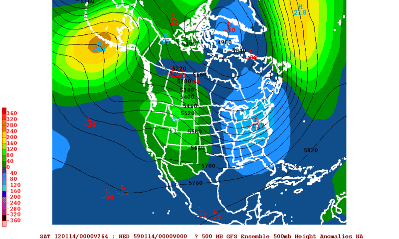
aggiecutter wrote:This tweet from Bastardi should raise a few eyebrows. On the left is the 12z 16 day GFS Ensemble 500MB HEIGHT/ANOMOLIES that I posted earlier today. On the right, are the anomalies for December 22-23 1983 and the surface temperatures for December 23-27 1983.

https://twitter.com/#!/BigJoeBastardi/s ... 56/photo/1


That was a brutal freeze here in the Valley! :froze:

Here is a nice recap from http://www.raingardens.com/psst/articles/artic03.htm

December 1983: The first bad freeze of the decade arrived in Brownsville on Christmas Eve 1983. Very cold weather had been entrenched in Texas for over a week when the big blow hit -- North Texas had experienced day after day of subfreezing weather, which each front colder than the previous. The low latitude of far South Texas had protected the area from the first few fronts, but on the 24th a severely cold air mass arrived which spared no area of the state. The temperature that day in Brownsville began sinking from 39° at midnight to 31° at 6:00 a.m. and 25° by noon, with an absolute minimum of 20° the next morning.

Most of the Valley was slightly colder -- McAllen recorded 19° and Weslaco had 17°. Though slightly shorter than the outbreaks of 1951 and 1962, this freeze brought a much longer sustained duration of temperature in the mid-twenties or below. Such a prolonged period of deep-freezing weather had not been seen in Brownsville since the previous century. It particularly resembled the cold outbreaks of 1852, 1873, and 1888.

This freeze may forever be known as the freeze that killed the palm trees in the Valley. Anyone who lived in the Valley before 1983 remembers well the thousands of tall slender Washingtonia robusta lining the local roads for mile after mile. The dead stumps were a sad sight on the Valley skyline for several years afterwards -- some still remain to this day. Citrus also received a good beating, the worst since 1951. The Valley got such a cleaning from 1983 it would almost make the worst freeze of the century seem anticlimactic.
0 likes   
The following post is NOT an official forecast and should not be used as such. It is just the opinion of the poster and may or may not be backed by sound meteorological data. It is NOT endorsed by any professional institution including storm2k.org For Official Information please refer to the NHC and NWS products.

austinrunner

Re:

#1608 Postby austinrunner » Mon Jan 02, 2012 11:39 pm

Rgv20 wrote:The 12zECMWF Ensemble Control Run is just downright COLD!!! With 850mb Temperatures -25C to -30C over Central Canada by mid month.


That would not be unusually cold, maybe 1 or 1.5 standard deviations below normal.
0 likes   

User avatar
Rgv20
S2K Supporter
S2K Supporter
Posts: 2466
Age: 39
Joined: Wed Jan 05, 2011 5:42 pm
Location: Edinburg/McAllen Tx

#1609 Postby Rgv20 » Mon Jan 02, 2012 11:53 pm

:uarrow: Should clarify it is South Central Canada and I believe Climo 850 Temperatures is around -8C to -10C which in turn would be 15C to 20C below normal.
0 likes   
The following post is NOT an official forecast and should not be used as such. It is just the opinion of the poster and may or may not be backed by sound meteorological data. It is NOT endorsed by any professional institution including storm2k.org For Official Information please refer to the NHC and NWS products.

austinrunner

Re: Texas Winter 2011-2012...

#1610 Postby austinrunner » Tue Jan 03, 2012 12:01 am

Palmer divide shadow wrote:Siberia is expecting -70-80 low temps next week


Where are you getting this information? For which part of Siberia? The coldest I've seen on the GFS forecast maps for the next 2 weeks is around -55F, which is not that unusually cold.
0 likes   

austinrunner

Re:

#1611 Postby austinrunner » Tue Jan 03, 2012 12:06 am

Rgv20 wrote::uarrow: Should clarify it is South Central Canada and I believe Climo 850 Temperatures is around -8C to -10C which in turn would be 15C to 20C below normal.


Like Winnipeg? GFS lowest surface temperature for that location over the next 16 days is forecast to be -25C. Lowest 850 mb forecasted temperature is -24C, with a surface temperature at that time of -19C.

Normal 850 mb temperature for Winnipeg is around -12C.

So, nothing terribly unusual in the 16-day GFS forecast for Winnipeg.
0 likes   

User avatar
iorange55
Category 5
Category 5
Posts: 2388
Joined: Thu Nov 13, 2008 9:47 pm
Location: Big D

Re: Texas Winter 2011-2012...

#1612 Postby iorange55 » Tue Jan 03, 2012 12:22 am

Safe bet we'll be receiving the coldest temps of the winter come mid January. However, it is way too early to tell if we'll get any winter precip out of it!

At least, we'll finally have the cold air in place.
0 likes   

austinrunner

Re: Texas Winter 2011-2012...

#1613 Postby austinrunner » Tue Jan 03, 2012 12:28 am

iorange55 wrote:Safe bet we'll be receiving the coldest temps of the winter come mid January. However, it is way too early to tell if we'll get any winter precip out of it!

At least, we'll finally have the cold air in place.


Not according to the GFS. Highs at KATT around 70 and lows in the 50s.
0 likes   

User avatar
Rgv20
S2K Supporter
S2K Supporter
Posts: 2466
Age: 39
Joined: Wed Jan 05, 2011 5:42 pm
Location: Edinburg/McAllen Tx

#1614 Postby Rgv20 » Tue Jan 03, 2012 12:38 am

Tonight's 0zGFS Ensembles continue to build some impressive 500mb Heights Anomalies over Alaska come mid January......This kind of pattern should help dislodged whatever cold air is up north.
Image
0 likes   
The following post is NOT an official forecast and should not be used as such. It is just the opinion of the poster and may or may not be backed by sound meteorological data. It is NOT endorsed by any professional institution including storm2k.org For Official Information please refer to the NHC and NWS products.

User avatar
Ntxw
Storm2k Moderator
Storm2k Moderator
Posts: 22790
Joined: Wed Oct 21, 2009 6:34 pm
Location: DFW, Texas

#1615 Postby Ntxw » Tue Jan 03, 2012 12:42 am

PNA is going negative, with the EPO possibly going slightly negative. This means the brunt of the cold pool will first aim for the PAC NW and Western Canada for the next 1-2 weeks. But this is also the source region Mr. Heat Miser hates seeing when it is cold! Eventually things will translate downstream if that Alaskan block develops. I agree with Rgv and iorange, things are not going to stay the same! We saw this last January, it got very warm until the end of the month after the -EPO and when the PNA went positive things started to dislodge.

Edit: Canadian is showing some Arklatex mischief at hr 120-132
0 likes   
The above post and any post by Ntxw is NOT an official forecast and should not be used as such. It is just the opinion of the poster and may or may not be backed by sound meteorological data. It is NOT endorsed by any professional institution including Storm2k. For official information, please refer to NWS products.

  Help support Storm2K!
Help Support Storm2K

User avatar
Texas Snowman
Storm2k Moderator
Storm2k Moderator
Posts: 6179
Joined: Fri Jan 25, 2008 11:29 am
Location: Denison, Texas

#1616 Postby Texas Snowman » Tue Jan 03, 2012 12:59 am

Bastardi says look out.

Cosgrove says maybe look out ("If the numerical models are correct, we will have our first -true- introduction of unmodified Arctic values in Houston late next week.").

Something tells me our beloved Wxman57 will have a rebuttal in the morning to try and dash all of our hopes, especially those at the PWC office! :D
0 likes   
The above post and any post by Texas Snowman is NOT an official forecast and should not be used as such. It is just the opinion of the poster and may or may not be backed by sound meteorological data. It is NOT endorsed by any professional institution including storm2k.org. For official information, please refer to NWS products.

User avatar
Ntxw
Storm2k Moderator
Storm2k Moderator
Posts: 22790
Joined: Wed Oct 21, 2009 6:34 pm
Location: DFW, Texas

#1617 Postby Ntxw » Tue Jan 03, 2012 1:43 am

Euro still has the system early week/weekend much like 12z. Looks a lot like Canadian but more intense. Maybe someone can get a miracle under it (this run likes PWC headquarters!) Looks cold enough aloft, and underneath the low surface cools too.

Edit: UK is similar to euro but shifts everything a bit more west,
0 likes   
The above post and any post by Ntxw is NOT an official forecast and should not be used as such. It is just the opinion of the poster and may or may not be backed by sound meteorological data. It is NOT endorsed by any professional institution including Storm2k. For official information, please refer to NWS products.


  Help support Storm2K!

Help Support Storm2K


Shoshana
Category 5
Category 5
Posts: 1414
Joined: Thu Sep 09, 2004 7:50 pm
Location: NE Austin

Re: Texas Winter 2011-2012...

#1618 Postby Shoshana » Tue Jan 03, 2012 2:21 am

So... came back from out of town and we have 1.5" of ice in the rain gauge. The temp gauge says 36...

The grass is wet around the rain gauge but not frozen.

Odd.
0 likes   

austinrunner

Re:

#1619 Postby austinrunner » Tue Jan 03, 2012 2:38 am

Ntxw wrote:PNA is going negative....

The 14-day PNA forecasts for the last 120-days have been highly unreliable.
http://www.cpc.ncep.noaa.gov/products/p ... _ensm.html
http://www.cpc.ncep.noaa.gov/products/p ... _mrf.shtml
0 likes   

User avatar
Portastorm
Storm2k Moderator
Storm2k Moderator
Posts: 9914
Age: 63
Joined: Fri Jul 11, 2003 9:16 am
Location: Round Rock, TX
Contact:

Re: Re:

#1620 Postby Portastorm » Tue Jan 03, 2012 10:16 am

austinrunner wrote:
Ntxw wrote:PNA is going negative....

The 14-day PNA forecasts for the last 120-days have been highly unreliable.
http://www.cpc.ncep.noaa.gov/products/p ... _ensm.html
http://www.cpc.ncep.noaa.gov/products/p ... _mrf.shtml


I'm not sure if you see the irony in calling out the quality (or lack thereof) of the PNA forecasts, yet you appear to be banking on GFS grid numbers for Austin's temps at the mid-month range. The 0z GFS operational run was vastly different from most of the ensemble members. But hey ... it's all good ... wxman57 needs some company in his "warmmongerer" camp and he appears to now have it.

The Grey Goose-swilling mets at the PWC say "let's see how things shake out in 10-12 days!" :wink:
0 likes   
Any forecasts under my name are to be taken with a grain of salt. Get your best forecasts from the National Weather Service and National Hurricane Center.


Return to “Winter Weather”

Who is online

Users browsing this forum: Google [Bot] and 36 guests