Texas Winter 2015-2016

Winter Weather Discussion

Moderator: S2k Moderators

Forum rules

The posts in this forum are NOT official forecast and should not be used as such. They are just the opinion of the poster and may or may not be backed by sound meteorological data. They are NOT endorsed by any professional institution or STORM2K.

Help Support Storm2K
Message
Author
orangeblood
S2K Supporter
S2K Supporter
Posts: 3714
Joined: Tue Dec 15, 2009 6:14 pm
Location: Fort Worth, TX

Re: Texas Winter 2015-2016

#1661 Postby orangeblood » Sun Jan 03, 2016 8:58 pm

Ntxw wrote:
hriverajr wrote:The question now is how far south will the Arctic air penetrate. Many of the models are showing a trend of cold air being held up.


My instincts tell me everything with plow southward. EPO is negative and may reach 3 SD's below normal That's a solid signal for Arctic attack. It's nothing to joke about the blocking that is going to occur up there. We just saw the same kind of idea happen in the Kara Sea and the intense cold that blasted the Black sea region below. There are very few cases where you will see Alaska/Yukon block sit like that. Nearly all of them plunged the lower 48 into a deep freeze.


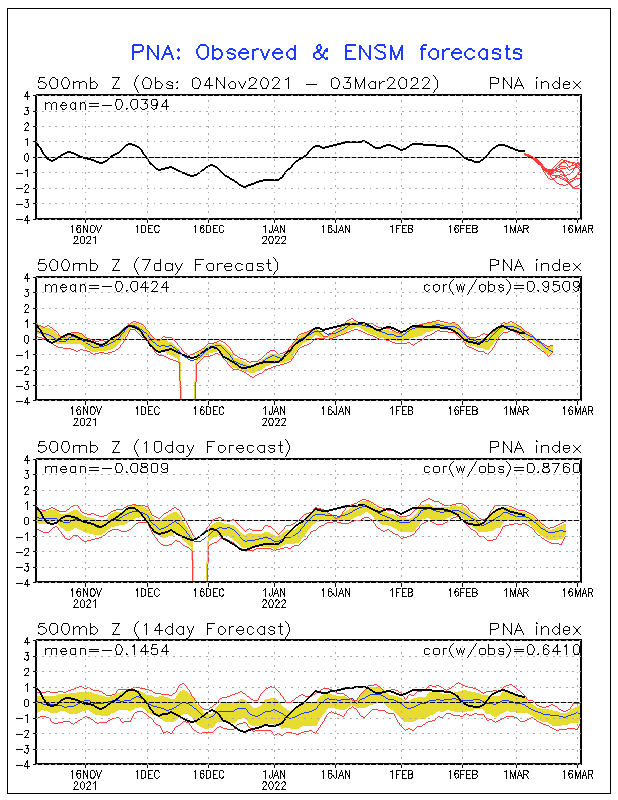
Yep, we seem to have this same discussion almost every year with these type synoptic setups....they almost always deliver! PNA is forecast under +2, this air should have no issue making it down into the southern plains.

Image
0 likes   

weatherdude1108
Category 5
Category 5
Posts: 4228
Joined: Tue Dec 13, 2011 1:04 pm
Location: Northwest Austin/Cedar Park, TX

#1662 Postby weatherdude1108 » Sun Jan 03, 2016 9:12 pm

Eye-catching conclusion to the EWX discussion this afternoon. :cold:

AREA FORECAST DISCUSSION
NATIONAL WEATHER SERVICE AUSTIN/SAN ANTONIO TX
505 PM CST SUN JAN 3 2016

.PREV DISCUSSION... /ISSUED 234 PM CST SUN JAN 3 2016/

SHORT TERM (TONIGHT THROUGH MONDAY NIGHT)...
DRIER AIR AND ISENTROPIC DOWNGLIDE WILL CONTINUE TO ERODE
CLOUDCOVER OVER THE EDWARDS PLATEAU AND RIO GRANDE PLAINS THIS
AFTERNOON...WITH MOST LOCATIONS IN OUR AREA CLEAR BY MID-EVENING.
THE CLEAR SKIES WILL ALLOW FOR FAVORABLE RADIATIONAL COOLING AND
THUS EXPECT LOW TEMPS FROM THE UPPER 20S IN THE HILL COUNTRY TO
THE MID 30S SOUTH. ALL AREAS EXPECTED TO REACH FREEZING OR BELOW
HAVE ALREADY HAD A FREEZE THIS YEAR...SO NO NEED FOR A FREEZE
WARNING. MONDAY WILL HAVE SIMILAR TEMPS TO TODAY DESPITE CLEAR
SKIES...AS WEAK COLD AIR ADVECTION CONTINUES. MONDAY NIGHT WILL
HAVE SIMILAR TEMPS TO TONIGHT.

LONG TERM (TUESDAY THROUGH SUNDAY)...
THE LONGWAVE PATTERN CHANGE OVER NORTH AMERICA DURING THE NEXT
WEEK...INITIALLY RESULTING IN FAST ZONAL FLOW ALONG THE
SUBTROPICAL JET THROUGH THE SOUTHERN HALF OF THE CONUS...RESULTING
A SERIES OF SHORTWAVE TROUGHS MOVING ACROSS TEXAS. NONE OF THESE
ARE DEEP...AND THEY ARE MOVING SO FAST THAT NEITHER EXTENSIVE
WARM OR COLD ADVECTION IS EXPECTED. A SLOW WARMING AND MOISTENING
WILL BRING MILDER OVERNIGHT LOWS BY THE END OF THE WEEK...BUT
HIGHS WILL REMAIN ABOUT THE SAME. WHILE SOME CHANCE FOR SHOWERS
BEGINS TUESDAY...THE BEST CHANCE FOR RAIN WILL BE WEDNESDAY NIGHT
AS THE DEEPEST TROUGH PASSES THROUGH. MODEL SOUNDINGS HAVE SMALL
AREAS OF CAPE...SO WE INCLUDED MENTION OF ISOLATED THUNDERSTORMS
WEDNESDAY NIGHT. RAIN SHOULD END EARLY THURSDAY...WITH THE REST
OF THE DAY AND FRIDAY REMAINING DRY. A WEAKER SHORTWAVE TROUGH
WILL BRING LOW POPS ON SATURDAY...BUT SUNDAY SHOULD BE DRY.

LOOKING FURTHER AHEAD...LONGER RANGE MODELS AND PATTERN
RECOGNITION INDICATORS SUCH AS CROSS-POLAR FLOW ARE ALIGNING FOR
AN ARCTIC AIR OUTBREAK IN THE JANUARY 12-16TH PERIOD. AT THIS
FORECAST RANGE...THE BEST ADVICE IS TO TAKE CARE OF OUTDOOR WORK
THIS COMING WEEK AND EARLY THE FOLLOWING WEEK
.
Last edited by weatherdude1108 on Sun Jan 03, 2016 10:59 pm, edited 1 time in total.
0 likes   
The preceding post is NOT an official forecast, and should not be used as such. It is only the opinion of the poster and may or may not be backed by sound meteorological data. It is NOT endorsed by any professional institution including storm2k.org. For Official Information please refer to the NHC and NWS products.
User avatar
Ptarmigan
Category 5
Category 5
Posts: 5316
Joined: Wed Aug 16, 2006 9:06 pm

Re: Texas Winter 2015-2016

#1663 Postby Ptarmigan » Sun Jan 03, 2016 10:14 pm

Ntxw wrote:
My instincts tell me everything with plow southward. EPO is negative and may reach 3 SD's below normal That's a solid signal for Arctic attack. It's nothing to joke about the blocking that is going to occur up there. We just saw the same kind of idea happen in the Kara Sea and the intense cold that blasted the Black sea region below. There are very few cases where you will see Alaska/Yukon block sit like that. Nearly all of them plunged the lower 48 into a deep freeze.


Anyone who wants to understand what is 1 standard deviation (SD) or 3 SD.

68–95–99.7 rule
https://en.wikipedia.org/wiki/68–95–99.7_rule

68%-1 SD
95%-2 SD
99.7%-3 SD
0 likes   

User avatar
TeamPlayersBlue
Category 5
Category 5
Posts: 3445
Joined: Tue Feb 02, 2010 1:44 am
Location: Denver/Applewood, CO

#1664 Postby TeamPlayersBlue » Sun Jan 03, 2016 11:32 pm

Are there any daily analogs we can look at to compare a blocking scenario like this? Such a rare event. ALso, is there a better archives site than the PSU site? Thanks!
0 likes   
Personal Forecast Disclaimer:
The posts in this forum are NOT official forecast and should not be used as such. They are just the opinion of the poster and may or may not be backed by sound meteorological data. They are NOT endorsed by any professional institution or storm2k.org. For official information, please refer to the NHC and NWS products.

User avatar
Ntxw
Storm2k Moderator
Storm2k Moderator
Posts: 22790
Joined: Wed Oct 21, 2009 6:34 pm
Location: DFW, Texas

#1665 Postby Ntxw » Sun Jan 03, 2016 11:42 pm

Another run, and another flip for the GFS. Back to sending down some cold again. At 5h it is all over the place run to run.
0 likes   
The above post and any post by Ntxw is NOT an official forecast and should not be used as such. It is just the opinion of the poster and may or may not be backed by sound meteorological data. It is NOT endorsed by any professional institution including Storm2k. For official information, please refer to NWS products.

  Help support Storm2K!
Help Support Storm2K

User avatar
Ntxw
Storm2k Moderator
Storm2k Moderator
Posts: 22790
Joined: Wed Oct 21, 2009 6:34 pm
Location: DFW, Texas

Re:

#1666 Postby Ntxw » Sun Jan 03, 2016 11:44 pm

TeamPlayersBlue wrote:Are there any daily analogs we can look at to compare a blocking scenario like this? Such a rare event. ALso, is there a better archives site than the PSU site? Thanks!


It's not a crazy rare event. 4-5 SD's (1983 type stuff) is the off the charts crazy. 3 SD's for the EPO occurs once a winter or every other. The past two winters we've seen a few more occurrences than typical.

ftp://ftp.cdc.noaa.gov/Public/gbates/teleconn/epo.reanalysis.t10trunc.1948-present.txt
0 likes   
The above post and any post by Ntxw is NOT an official forecast and should not be used as such. It is just the opinion of the poster and may or may not be backed by sound meteorological data. It is NOT endorsed by any professional institution including Storm2k. For official information, please refer to NWS products.


  Help support Storm2K!

Help Support Storm2K


User avatar
Texas Snowman
Storm2k Moderator
Storm2k Moderator
Posts: 6179
Joined: Fri Jan 25, 2008 11:29 am
Location: Denison, Texas

#1667 Postby Texas Snowman » Mon Jan 04, 2016 7:02 am

30 degrees in Denison, chalk another freeze up.
0 likes   
The above post and any post by Texas Snowman is NOT an official forecast and should not be used as such. It is just the opinion of the poster and may or may not be backed by sound meteorological data. It is NOT endorsed by any professional institution including storm2k.org. For official information, please refer to NWS products.

User avatar
wxman57
Moderator-Pro Met
Moderator-Pro Met
Posts: 22984
Age: 67
Joined: Sat Jun 21, 2003 8:06 pm
Location: Houston, TX (southwest)

Re:

#1668 Postby wxman57 » Mon Jan 04, 2016 8:45 am

weatherdude1108 wrote:Eye-catching conclusion to the EWX discussion this afternoon. :cold:

AREA FORECAST DISCUSSION
NATIONAL WEATHER SERVICE AUSTIN/SAN ANTONIO TX
505 PM CST SUN JAN 3 2016

...snip...THE BEST ADVICE IS TO TAKE CARE OF OUTDOOR WORK
THIS COMING WEEK AND EARLY THE FOLLOWING WEEK[/b]
.


Does that mean it won't be safe to go outdoors next week? Let's see, the 06Z GFS has north Houston dropping into the mid 20s next Wednesday. Yep, not safe for me to go outdoors...

I just remembered - I'll be in New Orleans for the annual AMS meeting next week. Surely Lake Pontchartrain will modify the cold air for me.
0 likes   

User avatar
ThunderSleetDreams
S2K Supporter
S2K Supporter
Posts: 1477
Age: 43
Joined: Tue Dec 20, 2011 4:42 pm
Location: S of Weimar, TX

Re: Texas Winter 2015-2016

#1669 Postby ThunderSleetDreams » Mon Jan 04, 2016 9:51 am

Gulf cruiser over cold air... I'm sure it will disappear/reappear 6 times over the next 11 days.

Image
0 likes   
#NeverSummer

I hibernate when it gets above 75 degrees!

orangeblood
S2K Supporter
S2K Supporter
Posts: 3714
Joined: Tue Dec 15, 2009 6:14 pm
Location: Fort Worth, TX

Re: Texas Winter 2015-2016

#1670 Postby orangeblood » Mon Jan 04, 2016 9:52 am

Classic Upper Level Setup for an Arctic Outbreak into the Lower 48....PV crashing into Minnesota with Cross-Polar Flow straight out of Siberia up and over the Pole into North America. Polar HPs coming down one after the other on most all models at this point, along with an active southern jet. Very interesting next few weeks coming up!!!

Image
0 likes   

aggiecutter
Category 5
Category 5
Posts: 1753
Joined: Thu Oct 14, 2004 9:22 pm
Location: Texarkana

Re: Texas Winter 2015-2016

#1671 Postby aggiecutter » Mon Jan 04, 2016 10:18 am

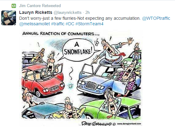
The reaction of Austin, Texas commuters (IF-WHEN) A snowflake EVER falls in the city itself.

Image
0 likes   

Ralph's Weather
S2K Supporter
S2K Supporter
Posts: 3269
Age: 38
Joined: Fri Dec 13, 2013 11:55 am
Location: Lindale, TX
Contact:

Re: Texas Winter 2015-2016

#1672 Postby Ralph's Weather » Mon Jan 04, 2016 10:25 am

orangeblood wrote:Classic Upper Level Setup for an Arctic Outbreak into the Lower 48....PV crashing into Minnesota with Cross-Polar Flow straight out of Siberia up and over the Pole into North America. Polar HPs coming down one after the other on most all models at this point, along with an active southern jet. Very interesting next few weeks coming up!!!

That is a very cold look for all but the West Coast. This is right on schedule from what was expected by many months ago. The Great Lakes will be the epicenter for the cold and Texas is where the STJ and the Polar jet meet which means we should be in line for multiple winter precip chances over the Jan. 12-25 period.
0 likes   
Follow on Facebook at Ralph's Weather.

aggiecutter
Category 5
Category 5
Posts: 1753
Joined: Thu Oct 14, 2004 9:22 pm
Location: Texarkana

Re: Texas Winter 2015-2016

#1673 Postby aggiecutter » Mon Jan 04, 2016 10:35 am

Ralph's Weather wrote:
orangeblood wrote:Classic Upper Level Setup for an Arctic Outbreak into the Lower 48....PV crashing into Minnesota with Cross-Polar Flow straight out of Siberia up and over the Pole into North America. Polar HPs coming down one after the other on most all models at this point, along with an active southern jet. Very interesting next few weeks coming up!!!

That is a very cold look for all but the West Coast. This is right on schedule from what was expected by many months ago. The Great Lakes will be the epicenter for the cold and Texas is where the STJ and the Polar jet meet which means we should be in line for multiple winter precip chances over the Jan. 12-25 period.


Just need the SOI to crash to get something major.
0 likes   

User avatar
Ntxw
Storm2k Moderator
Storm2k Moderator
Posts: 22790
Joined: Wed Oct 21, 2009 6:34 pm
Location: DFW, Texas

#1674 Postby Ntxw » Mon Jan 04, 2016 10:54 am

06z GFS has dfw down to 9F :lol: next it will have a low of 29...

Seriously though the pattern is ripe for deep conus cold
0 likes   
The above post and any post by Ntxw is NOT an official forecast and should not be used as such. It is just the opinion of the poster and may or may not be backed by sound meteorological data. It is NOT endorsed by any professional institution including Storm2k. For official information, please refer to NWS products.


  Help support Storm2K!

Help Support Storm2K


orangeblood
S2K Supporter
S2K Supporter
Posts: 3714
Joined: Tue Dec 15, 2009 6:14 pm
Location: Fort Worth, TX

Re: Texas Winter 2015-2016

#1675 Postby orangeblood » Mon Jan 04, 2016 10:54 am

aggiecutter wrote:
Ralph's Weather wrote:
orangeblood wrote:Classic Upper Level Setup for an Arctic Outbreak into the Lower 48....PV crashing into Minnesota with Cross-Polar Flow straight out of Siberia up and over the Pole into North America. Polar HPs coming down one after the other on most all models at this point, along with an active southern jet. Very interesting next few weeks coming up!!!

That is a very cold look for all but the West Coast. This is right on schedule from what was expected by many months ago. The Great Lakes will be the epicenter for the cold and Texas is where the STJ and the Polar jet meet which means we should be in line for multiple winter precip chances over the Jan. 12-25 period.


Just need the SOI to crash to get something major.


Ask and you shall receive......

SOI values for 04 Jan 2016

Average for last 30 days -9.82
Average for last 90 days -11.06
Daily contribution to SOI calculation -30.66
0 likes   

User avatar
Ntxw
Storm2k Moderator
Storm2k Moderator
Posts: 22790
Joined: Wed Oct 21, 2009 6:34 pm
Location: DFW, Texas

#1676 Postby Ntxw » Mon Jan 04, 2016 11:06 am

El Nino this week held steady at 2.7C. NINO 1+2 fell dramatically which means tropical forcing will center near the dateline. This is favorable for conus cold and roaring stj
0 likes   
The above post and any post by Ntxw is NOT an official forecast and should not be used as such. It is just the opinion of the poster and may or may not be backed by sound meteorological data. It is NOT endorsed by any professional institution including Storm2k. For official information, please refer to NWS products.


  Help support Storm2K!

Help Support Storm2K


Ralph's Weather
S2K Supporter
S2K Supporter
Posts: 3269
Age: 38
Joined: Fri Dec 13, 2013 11:55 am
Location: Lindale, TX
Contact:

#1677 Postby Ralph's Weather » Mon Jan 04, 2016 11:06 am

SHV throws in chance for changeover Saturday night in their discussion this morning. I will have to start model watching again to see if we can hold onto moisture long enough for the cold to build in.
0 likes   
Follow on Facebook at Ralph's Weather.

User avatar
perk
Category 3
Category 3
Posts: 825
Joined: Mon Aug 09, 2004 9:35 am
Location: Richmond Texas

Re: Texas Winter 2015-2016

#1678 Postby perk » Mon Jan 04, 2016 11:07 am

aggiecutter wrote:The reaction of Austin, Texas commuters (IF-WHEN) A snowflake EVER falls in the city itself.

Image


That's funny and i think that's the same reaction we would have in the Houston/Galveston area. :)
0 likes   

User avatar
srainhoutx
S2K Supporter
S2K Supporter
Posts: 6919
Age: 67
Joined: Sun Jan 14, 2007 11:34 am
Location: Haywood County, NC
Contact:

Re:

#1679 Postby srainhoutx » Mon Jan 04, 2016 11:20 am

Ralph's Weather wrote:SHV throws in chance for changeover Saturday night in their discussion this morning. I will have to start model watching again to see if we can hold onto moisture long enough for the cold to build in.


The 12Z GFS is in agreement with the 00Z Euro suggesting a robust shortwave and surface low moves across Texas Saturday into early Sunday.
0 likes   
Carla/Alicia/Jerry(In The Eye)/Michelle/Charley/Ivan/Dennis/Katrina/Rita/Wilma/Ike/Harvey

Member: National Weather Association
Wx Infinity Forums
http://wxinfinity.com/index.php

Facebook.com/WeatherInfinity
Twitter @WeatherInfinity

User avatar
gboudx
S2K Supporter
S2K Supporter
Posts: 4080
Joined: Thu Sep 04, 2003 1:39 pm
Location: Rockwall, Tx but from Harvey, La

#1680 Postby gboudx » Mon Jan 04, 2016 11:23 am

DFW made some mention of wintry precip this weekend as well.

THE WEEKEND SYSTEM HAS THE POTENTIAL TO BRING WINTRY WEATHER TO THE
REGION...BUT AT THIS TIME...IT LOOKS LIKE TEMPERATURES WILL NOT
BOTTOM OUT UNTIL AFTER THE RAINFALL HAS COME TO AN END.
0 likes   


Return to “Winter Weather”

Who is online

Users browsing this forum: No registered users and 49 guests