Next weekend looks interesting (if you like above-normal temps). Highs in the 70s. Not warm, but not cold:

Moderator: S2k Moderators
 The posts in this forum are NOT official forecast and should not be used as such. They are just the opinion of the poster and may or may not be backed by sound meteorological data. They are NOT endorsed by any professional institution or STORM2K.


Ntxw wrote:Alright folks time to get this thread rolling.
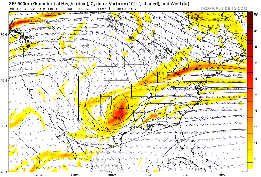
Strong upper disturbance will kick out this weekend and induce yet another rain event. Then followed by a surge of colder air and another strong disturbance. For some days most models keep this feature strung out and sheared but the GFS runs and Euro runs have given opportunity for a strong system to roll out of New Mexico. Definitely would keep an eye on this if moisture can be had from North/Northeast/East Texas middle of the week.
https://images2.imgbox.com/c0/b5/J2TZrMmz_o.png
Don't let the heat miser fool you with warm maps. The next 7 days look chilly.


Ntxw wrote:Alright folks time to get this thread rolling.
Strong upper disturbance will kick out this weekend and induce yet another rain event. Then followed by a surge of colder air and another strong disturbance. For some days most models keep this feature strung out and sheared but the GFS runs and Euro runs have given opportunity for a strong system to roll out of New Mexico. Definitely would keep an eye on this if moisture can be had from North/Northeast/East Texas middle of the week.
https://images2.imgbox.com/c0/b5/J2TZrMmz_o.png
Don't let the heat miser fool you with warm maps. The next 7 days look chilly.


TexasStorm wrote:Does TxDOT know something we don’t? Most of the signs around DFW today say ‘Watch for Winter Weather Road Crews’
Texas Snowman wrote:Ntxw wrote:Alright folks time to get this thread rolling.
Strong upper disturbance will kick out this weekend and induce yet another rain event. Then followed by a surge of colder air and another strong disturbance. For some days most models keep this feature strung out and sheared but the GFS runs and Euro runs have given opportunity for a strong system to roll out of New Mexico. Definitely would keep an eye on this if moisture can be had from North/Northeast/East Texas middle of the week.
https://images2.imgbox.com/c0/b5/J2TZrMmz_o.png
Don't let the heat miser fool you with warm maps. The next 7 days look chilly.Exactly, don’t feed the heat troll!

Brent wrote:TexasStorm wrote:Does TxDOT know something we don’t? Most of the signs around DFW today say ‘Watch for Winter Weather Road Crews’
money to burn at the end of the year?
12z Euro is really close to snowing in Dallas Wednesday Night


wxman57 wrote:On a more serious note, I'm looking at the projected 500mb flow in the GFS & FV3 GFS and don't see any prediction of a flow pattern that would bring Arctic south into the U.S. over the next two weeks. In order to have some significant snow across Texas (D-FW south to Houston), we need colder air than has been coming down the Plains. The predicted flow in the Euro is more favorable for getting some colder air down south. Considering how badly the GFS is with its long-range forecasts, I'd put more faith in the Euro's forecast. Still, I think we (TX) will have to wait until after January 15th for any reasonable shot at accumulating snow.
Brent wrote:TexasStorm wrote:Does TxDOT know something we don’t? Most of the signs around DFW today say ‘Watch for Winter Weather Road Crews’
money to burn at the end of the year?
12z Euro is really close to snowing in Dallas Wednesday Night
Users browsing this forum: TomballEd and 54 guests
