GFS and CMC will bomb again and Euro will leave Texas with lots of precip and cold weather!
Texas Winter 2012-2013
Moderator: S2k Moderators
Forum rules
 The posts in this forum are NOT official forecast and should not be used as such. They are just the opinion of the poster and may or may not be backed by sound meteorological data. They are NOT endorsed by any professional institution or STORM2K.

The posts in this forum are NOT official forecast and should not be used as such. They are just the opinion of the poster and may or may not be backed by sound meteorological data. They are NOT endorsed by any professional institution or STORM2K.
-
ThunderSleetDreams

- S2K Supporter

- Posts: 1510
- Age: 43
- Joined: Tue Dec 20, 2011 4:42 pm
- Location: S of Weimar, TX
Re: Texas Winter 2012-2013
NWS is changing their tune and siding with the Euro models for the upcoming storm.
GFS and CMC will bomb again and Euro will leave Texas with lots of precip and cold weather!
GFS and CMC will bomb again and Euro will leave Texas with lots of precip and cold weather!
0 likes
#NeverSummer
I hibernate when it gets above 75 degrees!
I hibernate when it gets above 75 degrees!
-
Rgv20

- S2K Supporter
- Posts: 2466
- Age: 39
- Joined: Wed Jan 05, 2011 5:42 pm
- Location: Edinburg/McAllen Tx
Rain chances look good for my area early next week...hopefully the trend continues! 
Corpus Christi NWS morning discussion..
LONG TERM (FRIDAY NIGHT THROUGH WEDNESDAY)...THE MODELS CONTINUE TO
HAVE DIFFICULTIES IN THEIR HANDLING OF THE CLOSED MID/UPR LOW WHICH
IS CURRENTLY LOCATED MORE THAN 1000 MILES WEST OF VANCOUVER.
THROUGH SUNDAY THE MODELS ARE IN EXCELLENT AGREEMENT IN BRINGING
THIS SYSTEM JUST WEST OF BAJA. BEYOND THAT THE MODELS DIVERGE WITH
THE ECMWF BEING THE SLOWEST SOLN AND THE GFS THE MOST PROGRESSIVE
SOLN. MOST GFS ENSEMBLE MEMBERS AND THE CANADIAN SOLN ARE MORE IN
LINE WITH THE GFS SOLN AND EVEN THE ECMWF SOLN HAS SPED THINGS UP
SLIGHTLY. THIS ALL LEADS TO THIS UPCOMING FCST BASED HEAVILY ON THE
MORE CONSISTENT GFS SOLN WHICH PROGS THIS SYSTEM TO BECOME OPEN AND
MOVE EAST OF THE CWA BY WED. SO AFTER A DRY AND COOL AIRMASS BUILDS
INTO THE CWA THROUGH SATURDAY NIGHT...TEMP AND MOISTURE ADVECTION WL
BEGIN BY SUNDAY MORNING. SUFFICIENTLY STRONG ISENTROPIC UPGLIDE AND
MOISTURE ADVECTION WL YIELD A DEVELOPING AREA OF LIGHT PCPN BY
SUNDAY AFTN. A COASTAL TROUGH/RETURNING WARM FRONT ACROSS THE SERN
PORTION OF THE CWA WL ADD TO THE KINEMATIC FORCING LATE SUNDAY INTO
MONDAY NIGHT. MEANWHILE...A BROAD AREA OF UPR LVL DIVERGENCE WL
PREVAIL ACROSS THE CWA AHEAD OF THE MAIN CLOSED LOW/SHORTWAVE. THE
RESULT WL BE THE BEST RAIN CHANCES DURING THE MON-TUE TIMEFRAME.
WHILE IT IS TOO EARLY TO TALK ABOUT QPF...IT IS WORTH NOTING THAT
WITH PROGGED PWATS CLOSE TO 2 INCHES THAT THIS WOULD REPRESENT NEAR
RECORD LEVEL PWATS FOR THIS TIME OF YEAR. SO WITH SUSTAINED PACIFIC
AND GULF MOISTURE TRANSPORT AND ADEQUATE DEEP LAYER FORCING...THE
THREAT FOR HEAVY RAIN WL EXIST WITH THIS SYSTEM DURING THE MON-TUE
TIMEFRAME. WL SLOWLY TAPER OFF RAIN CHANCES BY WED AS COLDER AND
DRIER AIR GRADUALLY DEEPENS ACROSS THE CWA. TEMPS THROUGHOUT THE
FCST PD WL BE MOSTLY BELOW NORMAL EXCEPT FOR SUNDAY NIGHT THROUGH
MONDAY NIGHT WHEN THE WARM FRONT PUSHES INLAND.
Brownsville NWS morning discussion..
MONDAY AND TUESDAY WE RETAIN PRETTY GOOD NAM/GFS AGREEMENT WITH GOOD
CONSENSUS AMONGST THE ENSEMBLE MEMBERS WITH BROAD AND FAIRLY STRONG
850MB WARM AIR ADVECTION ON SOUTHEASTERLIES. THERE IS STILL SOME
SPREAD IN GFS/ECMWF GUIDANCE WITH THE EURO STILL TRYING TO CUT OFF
THE UPPER LEVEL TROUGH AND SLOW FROPA UNTIL LATE TUESDAY
NIGHT...WITH THE GFS SAYING MORE TUESDAY MORNING. THE EURO IS RIGHT
THAT THERE IS PLENTY OF JET MOMENTUM EAST OF THE TROUGH...WHICH
SHOULD SLOW IT...BUT THE GFS IS RIGHT THAT THERE SHOULD BE ENOUGH
POLAR JET MOMENTUM TO KEEP THE LOW FROM COMPLETELY CLOSING OFF.
ENSEMBLE MEMBERS LEANED EURO SO KEPT THE FORECAST BASICALLY ON TRACK
WITH A FRONTAL PASSAGE TUESDAY NIGHT...WHICH IS CLOSE TO THE GFS
ENSEMBLE MEAN AND CLOSER TO THE ECMWF. MAXIMIZED POPS IN THE 12
HOURS SURROUNDING THE ANTICIPATED FROPA AND SUSPECT WE WILL BE IN A
CLOUDY AND SOMEWHAT DRIZZLY/RAINY PERIOD FROM SUNDAY AFTERNOON
THROUGH FROPA.
THE BROAD 300/500MB DIVERGENCE AND THE INCREASING TEMPERATURE
GRADIENT BETWEEN LAND AND SEA WILL LIKELY SET UP SOME SORT OF
COASTAL TROUGHING...WITH BOTH GLOBAL MODELS SUGGESTING SUCH AN
OUTCOME...ALTHOUGH THERE ARE TIMING AND STRENGTH DIFFERENCES. BOTH
MODELS ALSO AGREE ON THE IDEA OF SOME FRONTAL OVERRUNNING AS OUR MID
AND UPPER LEVEL WINDS STAY FAIRLY SOUTHWESTERLY AS A NEW TROUGH DIGS
INTO THE DESERT SOUTHWEST. SO KEPT POPS IN FOR ABOUT 18 TO 24 HOURS
AFTER FROPA. KEPT TEMPS IN THE TUNE OF ECWMF MOS TUESDAY SINCE WE
ARE NOT EXPECTING THE FRONT THROUGH AS QUICKLY AS GFS SUGGESTS FOR
NOW. ALSO KEPT A PRETTY THIN DIURNAL CURVE ON TEMPERATURES AS FAIRLY
THICK CLOUD COVER SHOULD KEEP THE NIGHTS MILDER AND THE DAYS MORE
MODERATE. THE COOLEST DAY OF THIS PERIOD FOR NOW IS FORECAST TO BE
WEDNESDAY WITH HIGHS IN THE LOW TO MID 60S AMID CLOUDY/DRIZZLY/LIGHT
RAIN SKIES. THE DAY 7 FORECAST IS CLOSER TO THE GFS WHICH CLEARS
EVERYTHING OUT AFTER A BRIEF PERIOD OF OVERRUNNING...HOWEVER IT
SHOULD BE NOTED THE 00Z ECMWF WITH ITS CUT OFF SOLUTION SUGGESTS A
FAIRLY EXTENDED PERIOD OF CLOUDS AND OVERRUNNING PRECIP...TWO TO
THREE DAYS WORTH SO WILL HAVE TO WATCH. LONG RANGE FORECAST
CONFIDENCE DETAILS WISE IS PRETTY LOW...BUT INCREASING ON
CLOUDS/TEMPS AND AT LEAST SOME RAINFALL.
0 likes
The following post is NOT an official forecast and should not be used as such. It is just the opinion of the poster and may or may not be backed by sound meteorological data. It is NOT endorsed by any professional institution including storm2k.org For Official Information please refer to the NHC and NWS products.
-
GaryHughes

- S2K Supporter
- Posts: 88
- Joined: Tue Dec 18, 2012 12:39 am
- Location: Parker County, near Springtown
Re: Texas Winter 2012-2013
FXUS64 KFWD 271601 AFDFWD
AREA FORECAST DISCUSSION NATIONAL WEATHER SERVICE FORT WORTH TX 1001 AM CST THU DEC 27 2012
.UPDATE... LOW STRATUS DECK HAS FORMED OVER THE NORTHEAST ZONES AND IS MAKING SOME SLOW PROGRESS WEST INTO THE METROPLEX. WITH SNOW STILL ON THE GROUND...LOW LEVEL INVERSION WILL BE TOUGH TO BREAK TODAY IN THIS AREA. WILL HOLD ONTO CLOUD COVER IN THE NORTHEAST ZONES THROUGH MID AFTERNOON AND HAVE LOWERED THE HIGHS IN THIS AREA A FEW DEGREES. MEANWHILE STRATUS DECK IN SOUTH TEXAS IS SURGING NORTH AND WILL MOVE INTO THE SOUTHEAST ZONES THIS AFTERNOON. HAVE SHOWN INCREASING CLOUDS IN THIS AREA AND LOWERED HIGHS A COUPLE OF DEGREES THERE AS WELL.
COLD FRONT WILL MOVE THROUGH TONIGHT AND HI-RES GUIDANCE IS INDICATING POST FRONTAL DRIZZLE LOOKS LIKE A GOOD BET ACROSS THE NORTHERN HALF OF THE AREA. TEMPS WILL ALSO BE NEAR FREEZING OVER THE NORTHWEST ZONES IN THE MORNING...AND THIS MAY BRING ABOUT A CONCERN FOR FREEZING DRIZZLE. HAVE ADDED DRIZZLE TO THE FORECAST FOR TOMORROW IN THE NORTHERN HALF OF THE AREA...INCREASED SKY COVER TO MOSTLY CLOUDY IN MOST OF THE AREA...AND SUBSEQUENTLY LOWERED HIGH TEMPS A FEW DEGREES. WILL AWAIT MORE MODEL DATA AND HAVE A LOOK AT AFTERNOON TRENDS TO SEE IF WE NEED TO ADD ANY FREEZING PRECIP TO THE FORECAST IN THE NW ZO
0 likes
The above post and any post by GaryHughes is NOT an official forecast and should not be used as such. It is just the opinion of the poster and may or may not be backed by sound meteorological data. It is NOT endorsed by any professional institution including storm2k.org. For official information, please refer to NWS products.
-
wxman57

- Moderator-Pro Met

- Posts: 23170
- Age: 68
- Joined: Sat Jun 21, 2003 8:06 pm
- Location: Houston, TX (southwest)
Re:
Ntxw wrote:Wxman57, what are your thoughts on the state of winter now that we enter the meat of it? I know anything beyond 5 days is moot, but just wanted to know what you believe overall the season will favor
My thoughts? I've had enough winter now. Dreaming of 90F warmth and long summer bike rides.
However, I don't expect any 90F temps over the next few weeks. Next week's storm system has a good chance of dropping more snow on north Texas around next Wednesday. However, the 12z GFS has a much weaker trof axis than earlier runs. I suspect it is in error. The southern stream should remain active for the next few weeks, bringing additional bouts of snow to TX (north TX, not SE TX). Wouldn't be surprised to see snow as far south as Waco in the next few weeks. Don't see any indication of extreme cold across TX (no, I don't mean below 80, I mean low 20s or colder in Houston, for example). It'll be just cold enough to be miserable to me without the joy of any near-80F days.
0 likes
Wxman57 says he would not be surprised to see snow as far south as Waco within a few weeks. Waco, but not Austin. Do we miss again. Snow just doesn't seem to like central Tx.
0 likes
Any opinions stated are those of an amateur, please take with several grains of salt and for official forecast refer to the National Weather Service.
-
weatherdude1108
- Category 5

- Posts: 4228
- Joined: Tue Dec 13, 2011 1:04 pm
- Location: Northwest Austin/Cedar Park, TX
So I got a LaCrosse wireless weather station from Santa. Has an indoor/outdoor temp/hygrometer, rain sensor, and anemometer. The directions say to put everything on same side of house. But they also say it is good to put temp/hygrometer on north side of house, but anemometer must face due south (solar powered). My roof faces north and south, so they would be on opposite sides of house if I put temp/humidity sensor on north side and wind on south side. I'm guessing I have to put everything on south side. But I do have a couple eaves on the south side that are facing north. Would that be more accurate? The sensors are covered in white colored covers that are vented like the pro mets have. Anyway, I know there is a forum for weather stations, but haven't found current one.  anyway, looking forward to using it and reporting!
0 likes
-
Portastorm

- Storm2k Moderator

- Posts: 9954
- Age: 63
- Joined: Fri Jul 11, 2003 9:16 am
- Location: Round Rock, TX
- Contact:
Re:
weatherdude1108 wrote:So I got a LaCrosse wireless weather station from Santa. Has an indoor/outdoor temp/hygrometer, rain sensor, and anemometer. The directions say to put everything on same side of house. But they also say it is good to put temp/hygrometer on north side of house, but anemometer must face due south (solar powered). My roof faces north and south, so they would be on opposite sides of house if I put temp/humidity sensor on north side and wind on south side. I'm guessing I have to put everything on south side. But I do have a couple eaves on the south side that are facing north. Would that be more accurate? The sensors are covered in white colored covers that are vented like the pro mets have. Anyway, I know there is a forum for weather stations, but haven't found current one.
Congrats! We look forward to seeing your data. I sent you a PM with some helpful (hopefully) info.
0 likes
Any forecasts under my name are to be taken with a grain of salt. Get your best forecasts from the National Weather Service and National Hurricane Center.
-
TeamPlayersBlue

- Category 5
- Posts: 3524
- Joined: Tue Feb 02, 2010 1:44 am
- Location: Denver/Applewood, CO
This is my next purchase. Looking to go all out!
0 likes
Personal Forecast Disclaimer:
The posts in this forum are NOT official forecast and should not be used as such. They are just the opinion of the poster and may or may not be backed by sound meteorological data. They are NOT endorsed by any professional institution or storm2k.org. For official information, please refer to the NHC and NWS products.
The posts in this forum are NOT official forecast and should not be used as such. They are just the opinion of the poster and may or may not be backed by sound meteorological data. They are NOT endorsed by any professional institution or storm2k.org. For official information, please refer to the NHC and NWS products.
-
somethingfunny

- ChatStaff

- Posts: 3926
- Age: 37
- Joined: Thu May 31, 2007 10:30 pm
- Location: McKinney, Texas
Re:
weatherdude1108 wrote:So I got a LaCrosse wireless weather station from Santa. Has an indoor/outdoor temp/hygrometer, rain sensor, and anemometer. The directions say to put everything on same side of house. But they also say it is good to put temp/hygrometer on north side of house, but anemometer must face due south (solar powered). My roof faces north and south, so they would be on opposite sides of house if I put temp/humidity sensor on north side and wind on south side. I'm guessing I have to put everything on south side. But I do have a couple eaves on the south side that are facing north. Would that be more accurate? The sensors are covered in white colored covers that are vented like the pro mets have. Anyway, I know there is a forum for weather stations, but haven't found current one.
I've got the same conundrum. I need to put my Acu-Rite five-in-one station in the shade so I'll get accurate temperature readings... but if it's in the shade, how will my rain gauge get rained on??? I haven't set it up yet, and I'm thinking about buying a separate rain gauge or a separate thermometer to compensate.
As for the next storm... we're still a long way out from it. The GFS is doing the usual thing it does by showing the storm at long-range, then dropping it in mid-range (where we are now) while the ECMWF continues to depict the storm. If this unfolds the way it usually does, the GFS will suddenly pick the storm up again two or three days out. Of course no model really knows what's going on until the upper level system comes ashore the west coast and we can send weather balloons up to sample its' attributes. The pattern sure looks good.
My snow is just about all gone here in south Garland, I'm thinking about driving up to Oklahoma or Arkansas this weekend to do some sledding and hiking in the snow-covered forests.
0 likes
I am not a meteorologist, and any posts made by me are not official forecasts or to be interpreted as being intelligent. These posts are just my opinions and are probably silly opinions.

-
Comanche

- Category 1

- Posts: 381
- Age: 54
- Joined: Wed Jul 06, 2005 9:33 am
- Location: Clear Lake City Texas
Not sure if you guys have seen this or not. I feel this is as good an explanation of the GFS vs. Euro as you will get...
http://cliffmass.blogspot.com/2012/12/r ... rvice.html
"...The National Weather Service efforts in global and national prediction are being undermined by lack of computer power. This is not just my opinion--ask leaders inside the weather service, National Academy committees, or knowledgeable folks in the field and they will tell you the same thing. Why are ECMWF's forecasts so much better than the NWS's? A big part of it is that ECMWF has the computer power to run their high-resolution global forecast at 16 km resolution, while ours is 25 km, their ensemble forecasting system has twice the resolution, and they can use an advanced data assimilation approach (4DVAR) that requires a lot of computer resources.
Consider the difference in the computer resources available to ECMWF versus the National Weather Service's Environmental Modeling Center (EMC), and keep in mind that EMC has a much wider range of responsibility (includes high resolution national and regional forecasting) than ECMWF (which does only global forecasting).
ECMWF has two machines, each with 24546 cores and a computational ability of .75 petaflops (thousand trillion floating point operations per second). These machines are #37 and 38 on the worldwide list of top 500 computers. The National Weather Service has two computers that are not even on the top 500 list. Each has 4992 processors and an ability to do .07 petaflops. You see the problem? The NWS has less than 10% of the computer power as ECMWF and has many more responsibilities..."
0 likes
-
Rgv20
- S2K Supporter
- Posts: 2466
- Age: 39
- Joined: Wed Jan 05, 2011 5:42 pm
- Location: Edinburg/McAllen Tx
Brownsville NWS afternoon discussion.....Let it Rain!
THE BEGINNING OF THE LONG TERM OR SATURDAY LOOKS TO BE FAIR WITH
SHORT WAVE RIDGING OVER SOUTH TEXAS. BELOW NORMAL TEMPERATURES ARE
FORECAST IN WAKE OF FRIDAY/S COLD FRONT. CLEAR SKIES AND COOL TO
COLD TEMPERATURES ARE EXPECTED SUNDAY MORNING BEFORE THE FORECAST
BEGINS TO DETERIORATE.
NO ONE MODEL IS SIMILAR BUT MOST ARE TRENDED TOWARDS A DEEPER
MERIDIONAL PATTERN WITH A BRIEF CUTOFF LOW DEVELOPING SOMEWHERE OFF
BAJA CA OR THE DESERT SOUTHWEST. THE ECMWF WAS THE MODEL OF
CHOICE WITH IT BEING THE MOST CONSISTENT AND BETWEEN THE MORE
PROGRESSIVE GFS AND THE SLOWER DEEPER CANADIAN. LOOKING FOR A DEEP
SOUTHWEST FLOW TO DEVELOP FROM SUNDAY THROUGH WEDNESDAY WITH
MOISTURE DEEPENING FROM BOTH THE PACIFIC AND GULF OF MEXICO. CHANCE
OF RAIN INCREASES THROUGH THE PERIOD WITH TUESDAY AND WEDNESDAY
LOOKING LIKE THE BEST DAYS AT THIS TIME WITH THE BEST DIVERGENT
FLOW AND WARM AIR ADVECTION COMBINING. COLD FRONT MOVES THROUGH ON
TUESDAY WITH SHALLOW AIR MASS TO BECOME ENTRENCHED WITH 850
SOUTHEAST FLOW STRENGTHEN WITH THE MAIN TROUGH HANGING BACK ACROSS
THE DESERT SOUTHWEST. IMPROVING CONDITIONS ARE EXPECTED BY
THURSDAY AS THE UPPER TROUGH FINALLY MAKE A MOVES EASTWARD AND
WEAKENS BUT IT MIGHT TAKE ALL DAY FOR THE VALLEY TO CLEAR. MORE
DETAILS AS THEY BECOME FOR CLEAR. STAY TUNED 2012 MAKE GO OUT LIKE
A WET LION.
0 likes
The following post is NOT an official forecast and should not be used as such. It is just the opinion of the poster and may or may not be backed by sound meteorological data. It is NOT endorsed by any professional institution including storm2k.org For Official Information please refer to the NHC and NWS products.

Re:
Comanche wrote:ECMWF has two machines, each with 24546 cores and a computational ability of .75 petaflops (thousand trillion floating point operations per second). These machines are #37 and 38 on the worldwide list of top 500 computers. The National Weather Service has two computers that are not even on the top 500 list. Each has 4992 processors and an ability to do .07 petaflops. You see the problem? The NWS has less than 10% of the computer power as ECMWF and has many more responsibilities..."
Yet our government keeps trying to take funding and staffing away from the NWS! But another thing here is that the NWS also has access to the same ECMWF data (assumingly) and more than us for sure doesn't explain the preference to the American models when they realize the lack of data and skill as mentioned in your post for any individual event. Use all the tools available.
0 likes
The above post and any post by Ntxw is NOT an official forecast and should not be used as such. It is just the opinion of the poster and may or may not be backed by sound meteorological data. It is NOT endorsed by any professional institution including Storm2k. For official information, please refer to NWS products.
Help support Storm2K!

Re: Texas Winter 2012-2013
DFW NWS being very cautious...
BY SUNDAY AN UPPER LEVEL LOW DROPS SOUTH ALONG THE CALIFORNIA
COAST LINE AND WILL BE LOCATED NEAR BAJA. MID-HIGH CLOUDS WILL
INVADE NORTH TEXAS DURING THE DAY SUNDAY WHICH WILL HAMPER ANY
ATTEMPTS AT AN APPRECIABLE WARM UP. AS THE UPPER LEVEL ENERGY
MOVES INTO THE DESERT SOUTHWEST...IT WILL TAP INTO THE GULF AND
GRAB SOME UNSEASONABLY HIGH PRECIPITABLE WATER VALUES OF 1.75+
INCHES. THIS WARM/MOIST AIR WILL BE LIFTED UP AND OVER THE COLD
DOME AT THE SURFACE AND A GOOD ISENTROPIC RAIN EVENT IS EXPECTED.
WIDESPREAD RAIN AMOUNTS OF 1 INCH WILL BE POSSIBLE MONDAY AS THE
LEAD IMPULSE TRACKS THROUGH. RAIN MAY SHUT DOWN OR TAPER OFF
TEMPORARILY MONDAY NIGHT FOR NEW YEARS FESTIVITIES...BUT IT IS A
LITTLE TOO FAR OFF TO MAKE ANY PROMISES. EITHER WAY...BEHIND THE
LEAD IMPULSE A COLD CANADIAN HIGH PRESSURE CELL WILL BUILD IN FROM
THE NORTH WITH THE TEMPS COOLING FURTHER ON TUESDAY/WEDNESDAY.
THE FORECAST GETS UNCERTAIN BY MIDWEEK. COLD AIR WILL DEFINITELY
BE IN PLACE...AND THERE IS UNANIMOUS MODEL AGREEMENT IN CONTINUED
TROUGHING/UPPER ENERGY ACROSS THE DESERT SW. THIS SETS THE STAGE
FOR A POSSIBLE WINTER WEATHER EVENT. THE UKMET/CANADIAN SHOW
FREEZING RAIN/SLEET WEDNESDAY. THE ECMWF HAS A VERY STRONG UPPER
SYSTEM MOVING OVER TEXAS WEDNESDAY NIGHT...BUT HAS NO MOISTURE
BECAUSE IT HAS STRONG/DRY NORTHERLY FLOW UP TO 750MB IN THE WAKE
OF THE TUESDAY FRONT. THE GFS IS THE WEAKEST WITH THE UPPER ENERGY
WEDNESDAY NIGHT...AND THEREFORE HAS LIMITED LIFT FOR PRECIP. AT
THIS STAGE...IT IS A WAIT AND SEE GAME BUT THERE IS CERTAINLY
POTENTIAL FOR WINTER WEATHER. WILL SHOW 20 POPS FOR LIQUID RAIN
WEDNESDAY AND KEEP TEMPS ABOVE 32 TO AVOID COMMITTING TO A WINTER
EVENT IN THE OFFICIAL FORECAST THIS FAR OUT.
TR.92
&&
0 likes
-
somethingfunny
- ChatStaff
- Posts: 3926
- Age: 37
- Joined: Thu May 31, 2007 10:30 pm
- Location: McKinney, Texas
Re: Texas Winter 2012-2013
Heads up for those to the northwest of DFW, nearer to Wichita Falls.

FWD is starting to irritate me with their reluctance to issue winter weather advisories and watches.
Isn't a Winter Weather Advisory just that? Advising the public that wintry weather could occur?
FWD is starting to irritate me with their reluctance to issue winter weather advisories and watches.
DRIZZLE IS EXPECTED TO CONTINUE BEHIND THE FRONT...AND SOME OF THE
HIGH RESOLUTION GUIDANCE IS SUGGESTING IT MAY BE FAIRLY INTENSE
ACROSS THE NORTHERN HALF OF THE CWA. THIS CREATES AN ISSUE OVER THE
NW ZONES WHERE TEMPERATURES WILL FALL BELOW FREEZING BEHIND THE
FRONT. THE MOIST AND SUBFREEZING LAYER WILL BE FAIRLY SHALLOW AND
TEMPERATURES SHOULD REMAIN ABOVE -8C IN THIS LAYER...SO NO ICE
NUCLEI WILL BE AVAILABLE FOR SNOW OR SLEET. THUS PRECIP TYPE WILL
BE A FREEZING DRIZZLE OR FREEZING LIGHT RAIN. WILL INCLUDE 20 POP
FOR FREEZING DRIZZLE IN THE NW ZONES FRIDAY MORNING. RIGHT NOW
THINK THAT AMOUNTS/COVERAGE SHOULD BE LIGHT...BUT IT MAY BE ENOUGH
TO COAT SOME OF THE BRIDGES/OVERPASSES WITH A GLAZE. NO WINTER
WEATHER ADVISORY WILL BE ISSUED JUST YET...BUT WE WILL HIGHLIGHT
THE THREAT IN GRAPHICS AND OTHER TEXT PRODUCTS.
Isn't a Winter Weather Advisory just that? Advising the public that wintry weather could occur?
0 likes
I am not a meteorologist, and any posts made by me are not official forecasts or to be interpreted as being intelligent. These posts are just my opinions and are probably silly opinions.
I think the problem with coming systems is the models do not want to settle on which one will intensify. To many moving parts, do they phase? Do they wait? Do they not move at all?!  One thing is known, cold air isn't lacking. DFW probably won't hit 50 this week, we have a brief window on Sunday, but after that things just tumble again. Tomorrow's high is 42 but that is in the morning before we fall behind the front.
I do believe there will be a big storm here just around and just after the new year, and we will zone in on the solution as the models slowly grasp the changes from the PNA
I do believe there will be a big storm here just around and just after the new year, and we will zone in on the solution as the models slowly grasp the changes from the PNA
0 likes
The above post and any post by Ntxw is NOT an official forecast and should not be used as such. It is just the opinion of the poster and may or may not be backed by sound meteorological data. It is NOT endorsed by any professional institution including Storm2k. For official information, please refer to NWS products.
Help support Storm2K!
Help support Storm2K!
-
somethingfunny
- ChatStaff
- Posts: 3926
- Age: 37
- Joined: Thu May 31, 2007 10:30 pm
- Location: McKinney, Texas
Re: Texas Winter 2012-2013
This is from the Facebook of a Sherman/Denison/Ardmore TV station:
KXII-TV
From Steve LaNore: Cold front has sped up and may come through before sunrise....this means there could be some freezing drizzle or even a few snowflakes toward sunrise. The evening should be dry and ice-free.
KXII-TV
From Steve LaNore: Cold front has sped up and may come through before sunrise....this means there could be some freezing drizzle or even a few snowflakes toward sunrise. The evening should be dry and ice-free.
0 likes
I am not a meteorologist, and any posts made by me are not official forecasts or to be interpreted as being intelligent. These posts are just my opinions and are probably silly opinions.
-
~FlipFlopGirl~

- Tropical Depression

- Posts: 52
- Age: 47
- Joined: Sat Jul 24, 2010 7:43 pm
- Location: Waco,TX
Re:
ndale wrote:Wxman57 says he would not be surprised to see snow as far south as Waco within a few weeks. Waco, but not Austin. Do we miss again. Snow just doesn't seem to like central Tx.
yeah!!!!
0 likes
-
Rgv20
- S2K Supporter
- Posts: 2466
- Age: 39
- Joined: Wed Jan 05, 2011 5:42 pm
- Location: Edinburg/McAllen Tx
Hey Ntxw have you seen the latest forecast on the Stratosphere Temperatures......Look at that crazy Stratospheric Warming forecast from the GFS!
Current..
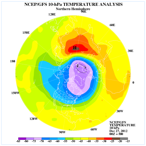
9 days from now
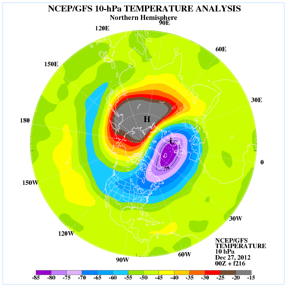
Current..
9 days from now
0 likes
The following post is NOT an official forecast and should not be used as such. It is just the opinion of the poster and may or may not be backed by sound meteorological data. It is NOT endorsed by any professional institution including storm2k.org For Official Information please refer to the NHC and NWS products.
-
GaryHughes
- S2K Supporter
- Posts: 88
- Joined: Tue Dec 18, 2012 12:39 am
- Location: Parker County, near Springtown
Re: Texas Winter 2012-2013
Rgv20 wrote:Hey Ntxw have you seen the latest forecast on the Stratosphere Temperatures......Look at that crazy Stratospheric Warming forecast from the GFS!
Current..
9 days from now
That seems Crazy?
0 likes
The above post and any post by GaryHughes is NOT an official forecast and should not be used as such. It is just the opinion of the poster and may or may not be backed by sound meteorological data. It is NOT endorsed by any professional institution including storm2k.org. For official information, please refer to NWS products.
Who is online
Users browsing this forum: Stratton23, txtwister78 and 40 guests