
Texas Winter 2018-2019
Moderator: S2k Moderators
Forum rules
 The posts in this forum are NOT official forecast and should not be used as such. They are just the opinion of the poster and may or may not be backed by sound meteorological data. They are NOT endorsed by any professional institution or STORM2K.

The posts in this forum are NOT official forecast and should not be used as such. They are just the opinion of the poster and may or may not be backed by sound meteorological data. They are NOT endorsed by any professional institution or STORM2K.

Re: Texas Winter 2018-2019
Euro looks like another pretty good run. It would be hard for the NWS to disregard it.
Still room for more qpf and coverage as the Euro is amped.
Still room for more qpf and coverage as the Euro is amped.
2 likes
The above post and any post by Ntxw is NOT an official forecast and should not be used as such. It is just the opinion of the poster and may or may not be backed by sound meteorological data. It is NOT endorsed by any professional institution including Storm2k. For official information, please refer to NWS products.
Help support Storm2K!
Re: Texas Winter 2018-2019
This will be something to watch I'd like to emphasize again. If the cold beats the surging moisture (per Euro) an event like this with a good STJ can have very high ceilings despite seemingly harmless. It's happened before, instead of light rain or sleet the initial band itself dumps 2-3" of snow before the main system even arrives. The band the Euro shows occurs from Morning of the 2nd to midday.
The simulated IR band of the Euro shows a STJ connection going on ahead of the system. The NAM will likely show some crazy totals soon I think since it is sensitive to these mesoscale and pooling moisture sources.
Ntxw wrote:The past several days have trended more towards a sig event.
One thing I am starting to see is if the storm may create more overrunning than anticipated well ahead of its passage while we have below freezing surface temperatures.
The simulated IR band of the Euro shows a STJ connection going on ahead of the system. The NAM will likely show some crazy totals soon I think since it is sensitive to these mesoscale and pooling moisture sources.
6 likes
The above post and any post by Ntxw is NOT an official forecast and should not be used as such. It is just the opinion of the poster and may or may not be backed by sound meteorological data. It is NOT endorsed by any professional institution including Storm2k. For official information, please refer to NWS products.
Help support Storm2K!
Help support Storm2K!
-
Brent
- S2K Supporter

- Posts: 38718
- Age: 37
- Joined: Sun May 16, 2004 10:30 pm
- Location: Tulsa Oklahoma
- Contact:
Re: Texas Winter 2018-2019
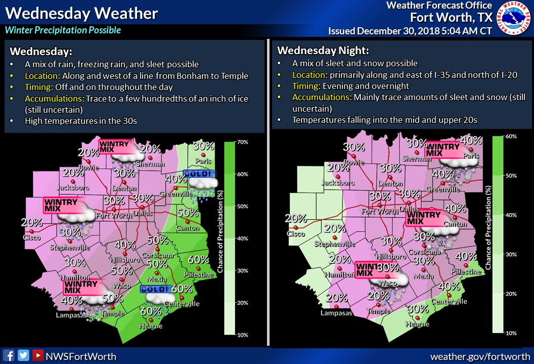
ice storm by early afternoon Wednesday in DFW and down close to the 35 corridor towards Austin on the 6z NAM  only goes out to 18z Wednesday


only goes out to 18z Wednesday
0 likes
#neversummer
-
Ralph's Weather
- S2K Supporter
- Posts: 3371
- Age: 38
- Joined: Fri Dec 13, 2013 11:55 am
- Location: Lindale, TX
- Contact:
Re: Texas Winter 2018-2019
The GFS is alone in its thought on the dominant northern stream. Every other global model I checked (8 or so of them) have a SW closed low dominating things. As others have noted the STJ could well play a big role in supporting significant precip early on Wed. The NAM is really showing this. Temps are likely to trend colder for the daytime on Wed. I doubt areas west of I-35 or north of I-20 get above freezing on Wed. I hope that there is not much of a warm nose or we coups have significant icing for some before the snow. The NAM is on the warm side of guidance right now.
The support for NE Texas getting much snow is now lost sadly as all models track the upper low from W TX into OK vs earlier runs tracking along I-20. With first trends NE TX is only in line for backside flurries as we will be ok the SW flank of the upper low late Wed. For my sake I am hoping that the storm tracks south of El Paso and ejects a bit more E vs NE. This would put us on the W flank late Wed which is where the real snow is gonna fall.
The support for NE Texas getting much snow is now lost sadly as all models track the upper low from W TX into OK vs earlier runs tracking along I-20. With first trends NE TX is only in line for backside flurries as we will be ok the SW flank of the upper low late Wed. For my sake I am hoping that the storm tracks south of El Paso and ejects a bit more E vs NE. This would put us on the W flank late Wed which is where the real snow is gonna fall.
1 likes
Follow on Facebook at Ralph's Weather.
-
Ralph's Weather
- S2K Supporter
- Posts: 3371
- Age: 38
- Joined: Fri Dec 13, 2013 11:55 am
- Location: Lindale, TX
- Contact:
Re: Texas Winter 2018-2019
06Z GFS through Tue evening is trending towards a stronger SW low. But of course it ends up shearing it out. It does put some snow down though.
0 likes
Follow on Facebook at Ralph's Weather.
-
Ralph's Weather
- S2K Supporter
- Posts: 3371
- Age: 38
- Joined: Fri Dec 13, 2013 11:55 am
- Location: Lindale, TX
- Contact:
Re: Texas Winter 2018-2019
I really should be asleep, but something ascot this storm seems special so I can't sleep. It looks to me that a track just a bit further south even just 100 miles south Tues night when it is along the NM/Mex border would invoke analogs to 2/11/2010. Very minor shifts among the various features could shift this from a nothing event to a widespread heavy snow event.
2 likes
Follow on Facebook at Ralph's Weather.
-
cheezyWXguy

- Category 5

- Posts: 6280
- Joined: Mon Feb 13, 2006 12:29 am
- Location: Dallas, TX
Re: Texas Winter 2018-2019
Dallas forecast update has been updated to include 30% chance rain/freezing rain on Tuesday night, wintry mix on Wednesday, and snow Wednesday night. Not surprising since the euro, gfs, fv3, nam, and cmc all show at least light accumulations in Dfw.
Trends continue in our favor...
Trends continue in our favor...
3 likes
Re: Texas Winter 2018-2019
Before we get any frozen fun next week, a cold rainy Sunday is on tap. Good day to stay indoors and watch some NFL and eat. Can't wait to see some good trends today.
2 likes
Re: Texas Winter 2018-2019
Looks like GFS and FV3 folded at least based on 6z. All hail king Euro.
2 likes
The above post and any post by Ntxw is NOT an official forecast and should not be used as such. It is just the opinion of the poster and may or may not be backed by sound meteorological data. It is NOT endorsed by any professional institution including Storm2k. For official information, please refer to NWS products.
Help support Storm2K!
Help support Storm2K!
-
weatherdude1108
- Category 5
- Posts: 4228
- Joined: Tue Dec 13, 2011 1:04 pm
- Location: Northwest Austin/Cedar Park, TX
Re: Texas Winter 2018-2019

With models trending colder and wetter for the middle of the week parts of the Hill Country and Edwards Plateau have a chance for freezing rain early Wednesday morning, through much of the day, and into the evening hours. While it is too soon to determine the impacts from this potential freezing rain, continue to monitor the forecast over the next several days.
0 likes
The preceding post is NOT an official forecast, and should not be used as such. It is only the opinion of the poster and may or may not be backed by sound meteorological data. It is NOT endorsed by any professional institution including storm2k.org. For Official Information please refer to the NHC and NWS products.
-
orangeblood
- S2K Supporter
- Posts: 3895
- Joined: Tue Dec 15, 2009 6:14 pm
- Location: Fort Worth, TX
Re: Texas Winter 2018-2019
Ntxw wrote:Looks like GFS and FV3 folded at least based on 6z. All hail king Euro.
Yep, the gap between King Euro and the rest hasn’t changed much in years...once in a blue moon the GFS will get lucky but overall seems inferior and sometimes embarrassingly so!
3 likes


Re: Texas Winter 2018-2019
Brent wrote:ice storm by early afternoon Wednesday in DFW and down close to the 35 corridor towards Austin on the 6z NAM
http://i64.tinypic.com/9strgk.png
Please let this verify!!!! DFW people need this lol! Our New Year's wishes will come true! I know DFWers will be happier than kids on Christmas! If this moves north I am packing up the car and going to find this white stuff everyone keeps talking about! Fingers crossed DFWers! Could it FINALLY be our turn?!!!!

As for today, woke up to a crisp 37 outside with rain in the forecast. I'll be staying inside under my blanket watching football all day! Go Cowboys! Happy Sunday everyone!
1 likes
-
orangeblood
- S2K Supporter
- Posts: 3895
- Joined: Tue Dec 15, 2009 6:14 pm
- Location: Fort Worth, TX
Re: Texas Winter 2018-2019
12Z NAM continues trend towards EURO with deeper cut-off and after looking over SREF temp projections, this could become quite an ugly ice storm for some...the Globals and even the NAM don’t seem cold enough
Last edited by orangeblood on Sun Dec 30, 2018 9:52 am, edited 1 time in total.
0 likes
Re: Texas Winter 2018-2019
If this trend continues we'll probably see most of North Texas and counties West of I-35 in the hill country under winter storm watches pretty soon I would think.
2 likes
The above post and any post by Ntxw is NOT an official forecast and should not be used as such. It is just the opinion of the poster and may or may not be backed by sound meteorological data. It is NOT endorsed by any professional institution including Storm2k. For official information, please refer to NWS products.
Help support Storm2K!
Help support Storm2K!

Re: Texas Winter 2018-2019
Ntxw wrote:If this trend continues we'll probably see most of North Texas and counties West of I-35 in the hill country under winter storm watches pretty soon I would think.
Why wouldn't we see all of north Texas and southern Oklahoma under WSW?
0 likes
Re: Texas Winter 2018-2019
Jarodm12 wrote:Ntxw wrote:If this trend continues we'll probably see most of North Texas and counties West of I-35 in the hill country under winter storm watches pretty soon I would think.
Why wouldn't we see all of north Texas and southern Oklahoma under WSW?
I took a guess based on model placement of best qpf and timing since it will start in those areas first. Adjacent Oklahoma too and Arkansas, only qpf there is not certain yet.
1 likes
The above post and any post by Ntxw is NOT an official forecast and should not be used as such. It is just the opinion of the poster and may or may not be backed by sound meteorological data. It is NOT endorsed by any professional institution including Storm2k. For official information, please refer to NWS products.
Help support Storm2K!
Help support Storm2K!
-
bubba hotep

- S2K Supporter
- Posts: 6012
- Joined: Wed Dec 28, 2016 1:00 am
- Location: Collin County Texas
Re: Texas Winter 2018-2019
bubba hotep wrote:For the Wednesday system, one of the things we need to watch is the Northern Steam wave. It was much stronger on the 00z Euro and eventually overruns the system coming out of New Mexico. On the 12z today, it is barely there and stays a lot farther north allowing our system to come out of New Mexico with more amplitude.
00z Euro with strong Northern Stream wave.
https://i.ibb.co/m6HdFM9/us-model-en-087-0-modez-2018122800-108-5436-457.png
12z Euro with just a ripple in the Northern Stream
https://i.ibb.co/9vk5z4L/us-model-en-087-0-modez-2018122812-96-5436-457.png
It's impressive how consistent the Euro has been since it dropped the dominate Northern Stream feature. The GFS and FV3 are still playing catch up trying to trend towards the Euro but they are still showing more Northern Stream interference.
1 likes
Winter time post are almost exclusively focused on the DFW area.
-
bubba hotep
- S2K Supporter
- Posts: 6012
- Joined: Wed Dec 28, 2016 1:00 am
- Location: Collin County Texas
-
Portastorm

- Storm2k Moderator

- Posts: 9954
- Age: 63
- Joined: Fri Jul 11, 2003 9:16 am
- Location: Round Rock, TX
- Contact:
Re: Texas Winter 2018-2019
Silly NAM! 

3 likes
Any forecasts under my name are to be taken with a grain of salt. Get your best forecasts from the National Weather Service and National Hurricane Center.
Who is online
Users browsing this forum: rylo7956, Stratton23, Will_TX and 26 guests