My most memorable winter period was December 2000 in Kansas. Got a little bit of snow, then a big snow, then it was so frigid it didn't melt for weeks, which was incredibly rare. Normally there it would melt in a few days as well. A lot of the same issues we faced here I faced growing up, as big cold usually dried us out etc. There were more exceptions where we could get some dry snow with high ratios, but it was rare. It made for a magical month actually having snow on the ground most of the time.
I was getting concerned when nobody was posting model runs, so glad to see it. Probably one of these OK storms will trend our way eventually.
Texas Winter 2020-2021
Moderator: S2k Moderators
Forum rules
 The posts in this forum are NOT official forecast and should not be used as such. They are just the opinion of the poster and may or may not be backed by sound meteorological data. They are NOT endorsed by any professional institution or STORM2K.

The posts in this forum are NOT official forecast and should not be used as such. They are just the opinion of the poster and may or may not be backed by sound meteorological data. They are NOT endorsed by any professional institution or STORM2K.
-
rwfromkansas
- Category 5

- Posts: 3010
- Joined: Sat Aug 27, 2005 12:47 am
- Location: North Fort Worth
Re: Texas Winter 2020-2021
2 likes
-
Iceresistance

- Category 5
- Posts: 9566
- Age: 22
- Joined: Sat Oct 10, 2020 9:45 am
- Location: Tecumseh, OK/Norman, OK
Re: Texas Winter 2020-2021
rwfromkansas wrote:My most memorable winter period was December 2000 in Kansas. Got a little bit of snow, then a big snow, then it was so frigid it didn't melt for weeks, which was incredibly rare. Normally there it would melt in a few days as well. A lot of the same issues we faced here I faced growing up, as big cold usually dried us out etc. There were more exceptions where we could get some dry snow with high ratios, but it was rare. It made for a magical month actually having snow on the ground most of the time.
I was getting concerned when nobody was posting model runs, so glad to see it. Probably one of these OK storms will trend our way eventually.
The 18z & 0z runs had nothing, but the 6z run really got my attention
Highly depends on the storms tracks, there are 3 options for snow to come in, all in a one month.
All it takes for Storm #1 & 2 to be a winter storm for you is to be on the northern end of the moisture, then it might snow. Storm #3 is too far north, but it's VERY far out & will change.

0 likes
Bill 2015 & Beta 2020
Winter 2020-2021
All observations are in Tecumseh, OK unless otherwise noted.
Winter posts are focused mainly for Oklahoma & Texas.
Take any of my forecasts with a grain of salt, refer to the NWS, SPC, and NHC for official information
Never say Never with weather! Because ANYTHING is possible!
Winter 2020-2021
All observations are in Tecumseh, OK unless otherwise noted.
Winter posts are focused mainly for Oklahoma & Texas.
Take any of my forecasts with a grain of salt, refer to the NWS, SPC, and NHC for official information
Never say Never with weather! Because ANYTHING is possible!
-
bubba hotep

- S2K Supporter

- Posts: 6012
- Joined: Wed Dec 28, 2016 1:00 am
- Location: Collin County Texas
-
Iceresistance
- Category 5
- Posts: 9566
- Age: 22
- Joined: Sat Oct 10, 2020 9:45 am
- Location: Tecumseh, OK/Norman, OK
Re: Texas Winter 2020-2021
No joke on the Wind Alerts!
Observations from the NWS-Norman area

0 likes
Bill 2015 & Beta 2020
Winter 2020-2021
All observations are in Tecumseh, OK unless otherwise noted.
Winter posts are focused mainly for Oklahoma & Texas.
Take any of my forecasts with a grain of salt, refer to the NWS, SPC, and NHC for official information
Never say Never with weather! Because ANYTHING is possible!
Winter 2020-2021
All observations are in Tecumseh, OK unless otherwise noted.
Winter posts are focused mainly for Oklahoma & Texas.
Take any of my forecasts with a grain of salt, refer to the NWS, SPC, and NHC for official information
Never say Never with weather! Because ANYTHING is possible!
-
Brent
- S2K Supporter
- Posts: 38704
- Age: 37
- Joined: Sun May 16, 2004 10:30 pm
- Location: Tulsa Oklahoma
- Contact:
Re: Texas Winter 2020-2021
As I was leaving Tulsa this afternoon I saw about 5 minutes of flurries
3 times this winter not at home
3 times this winter not at home
4 likes
#neversummer
-
cheezyWXguy

- Category 5
- Posts: 6280
- Joined: Mon Feb 13, 2006 12:29 am
- Location: Dallas, TX
Re: Texas Winter 2020-2021
Man it’s dead here. Still think that storm around 228hr on the gfs is worth watching, as the 500mb ridge over Texas at that time seems to be trending weaker and further south. Maybe the storm will trend further south too.
4 likes
-
bubba hotep
- S2K Supporter
- Posts: 6012
- Joined: Wed Dec 28, 2016 1:00 am
- Location: Collin County Texas

-
cheezyWXguy
- Category 5
- Posts: 6280
- Joined: Mon Feb 13, 2006 12:29 am
- Location: Dallas, TX
Re: Texas Winter 2020-2021
Hooray, finally something on the 12z gfs. We can just ignore that is 348hrs away
1 likes
-
Texas Snow

- S2K Supporter
- Posts: 817
- Joined: Mon Oct 19, 2015 12:06 pm
- Location: N. Dallas & Cedar Creek Lake
Re: Texas Winter 2020-2021
cheezyWXguy wrote:Hooray, finally something on the 12z gfs. We can just ignore that is 348hrs away
348 is the new 72
4 likes
"Don't let wishcastin get in the way of your forecastin"

-
txtwister78

- Category 5
- Posts: 2139
- Joined: Wed Jan 30, 2019 12:56 pm
- Location: San Antonio
Re: Texas Winter 2020-2021


Euro ENS has TX locked in to a warmer than normal temp pattern in the longer term. -PNA is the big factor overall. The EPO actually does go negative for a week, but due to the -PNA most of the cold air that does enter the US will be blocked from coming too far south. We need to root for the PNA to go back to neutral or positive in order for us to get back to a wintry pattern. Right now doesn't look likely thru the end of the month.
What does look more likely is some good rain entering the forecast for the state next week. We definitely could use it across a good portion of the state.
3 likes
-
Iceresistance
- Category 5
- Posts: 9566
- Age: 22
- Joined: Sat Oct 10, 2020 9:45 am
- Location: Tecumseh, OK/Norman, OK
Re: Texas Winter 2020-2021
txtwister78 wrote:https://images.weatherbell.com/model/ecmwf-ensemble-avg/conus/t2m_f_anom_5day/1610798400/1611662400-vZnNb5qlLQY.png
https://images.weatherbell.com/model/ecmwf-ensemble-avg/conus/t2m_f_anom_5day/1610798400/1612094400-GkQyqHxVD7w.png
https://images.weatherbell.com/model/gfs-deterministic/tx/total_precip_inch/1610820000/1611360000-q388M1tBnnU.png
Euro ENS has TX locked in to a warmer than normal temp pattern in the longer term. -PNA is the big factor overall. The EPO actually does go negative for a week, but due to the -PNA most of the cold air that does enter the US will be blocked from coming too far south. We need to root for the PNA to go back to neutral or positive in order for us to get back to a wintry pattern. Right now doesn't look likely thru the end of the month.
What does look more likely is some good rain entering the forecast for the state next week. We definitely could use it across a good portion of the state.
If there can't be snow, I'll take any rain needed to keep away the drought from coming to the eastern side of the Southern Plains
3 likes
Bill 2015 & Beta 2020
Winter 2020-2021
All observations are in Tecumseh, OK unless otherwise noted.
Winter posts are focused mainly for Oklahoma & Texas.
Take any of my forecasts with a grain of salt, refer to the NWS, SPC, and NHC for official information
Never say Never with weather! Because ANYTHING is possible!
Winter 2020-2021
All observations are in Tecumseh, OK unless otherwise noted.
Winter posts are focused mainly for Oklahoma & Texas.
Take any of my forecasts with a grain of salt, refer to the NWS, SPC, and NHC for official information
Never say Never with weather! Because ANYTHING is possible!
-
TheProfessor

- Professional-Met

- Posts: 3506
- Age: 29
- Joined: Tue Dec 03, 2013 10:56 am
- Location: Wichita, Kansas
Re: Texas Winter 2020-2021
Iceresistance wrote:txtwister78 wrote:https://images.weatherbell.com/model/ecmwf-ensemble-avg/conus/t2m_f_anom_5day/1610798400/1611662400-vZnNb5qlLQY.png
https://images.weatherbell.com/model/ecmwf-ensemble-avg/conus/t2m_f_anom_5day/1610798400/1612094400-GkQyqHxVD7w.png
https://images.weatherbell.com/model/gfs-deterministic/tx/total_precip_inch/1610820000/1611360000-q388M1tBnnU.png
Euro ENS has TX locked in to a warmer than normal temp pattern in the longer term. -PNA is the big factor overall. The EPO actually does go negative for a week, but due to the -PNA most of the cold air that does enter the US will be blocked from coming too far south. We need to root for the PNA to go back to neutral or positive in order for us to get back to a wintry pattern. Right now doesn't look likely thru the end of the month.
What does look more likely is some good rain entering the forecast for the state next week. We definitely could use it across a good portion of the state.
If there can't be snow, I'll take any rain needed to keep away the drought from coming to the eastern side of the Southern Plains
Speaking of drought. This was brought to my attention by a brilliant grad student that I know on another site, but where the current drought in the Southwest expands will be critical to determining where a possible large tornado outbreak could occur this Spring. It is likely that the drought will influence EMLs, possibly pushing stronger EMLs further east due to the dryline either setting up further east or just progressing eastward more easily due to dry land. Where the boundary of the drought is is important to DFW and east Texas and Dixie Alley. In 2011 DFW and east Texas ended up on the western edge of the Super Outbreak. One thing that's different this year than 2011 is that in 2011 east Texas got the worst of the drought early on, whereas right now it's mostly confined to west Texas. Now CPC does expect much of the Southern Plains to be in drought this year, but if stays just abnormally dry instead of being a severe drought, that could influence how far east EMLs get. To put it plainly, if the drought is focused further west this year, but EMLs are occurring further east than average with an active tornado season to go with it, then we could see the hard hit areas shift west from 2011, focusing on east Texas, Louisiana, and Mississippi instead of Mississippi, Alabama, and Georgia. It wouldn't surprise if DFW saw a lot more dry line action this year, which does mean you might not get anything, but we also know that drylines produce some of the most dangerous supercells and tornadoes we've seen. EMLs poking into Louisiana and Mississippi also mean trouble because it limits the junk convection that often causes busts in Dixie Alley (I should probably throw Arkansas in the list of these states as well). Further east where EMLs may not quite reach, that junk convection still exists so outbreaks are quite as widespread as what we saw in 2011.
I should point out that I'm not saying there's going to be an outbreak that rivals 2011 this spring, but let's be real, even an outbreak half as bad as that would be seriously bad. Unless we get put into full on winter mode nation wide, there will probably be at least 1 bad outbreak this year.
5 likes
An alumnus of The Ohio State University.
Your local National Weather Service office is your best source for weather information.
Your local National Weather Service office is your best source for weather information.
-
Portastorm

- Storm2k Moderator

- Posts: 9954
- Age: 63
- Joined: Fri Jul 11, 2003 9:16 am
- Location: Round Rock, TX
- Contact:
Re: Texas Winter 2020-2021
Don’t know how many of y’all subscribe to Larry Cosgrove’s newsletter but his latest edition builds (what seems to me at least) a solid case for a big pattern change at the end of the month. Much colder and stormier pattern for east of the Rockies.
6 likes
Any forecasts under my name are to be taken with a grain of salt. Get your best forecasts from the National Weather Service and National Hurricane Center.
-
orangeblood
- S2K Supporter
- Posts: 3895
- Joined: Tue Dec 15, 2009 6:14 pm
- Location: Fort Worth, TX
Re: Texas Winter 2020-2021
Portastorm wrote:Don’t know how many of y’all subscribe to Larry Cosgrove’s newsletter but his latest edition builds (what seems to me at least) a solid case for a big pattern change at the end of the month. Much colder and stormier pattern for east of the Rockies.
I’m not a subscriber but the Ensembles don’t look like they’re giving that indication...this is an incredibly ugly chart for the start to February. Cold will be bottled up in Alaska/NW Canada if this chart is even close to reality. Just no indication of a mechanism to push cold south across the southern US attm

2 likes
-
Portastorm
- Storm2k Moderator
- Posts: 9954
- Age: 63
- Joined: Fri Jul 11, 2003 9:16 am
- Location: Round Rock, TX
- Contact:
Re: Texas Winter 2020-2021
Well, to be fair to Mr. Cosgrove, he said the “start” of a pattern change would begin in early February. 
3 likes
Any forecasts under my name are to be taken with a grain of salt. Get your best forecasts from the National Weather Service and National Hurricane Center.
-
bubba hotep
- S2K Supporter
- Posts: 6012
- Joined: Wed Dec 28, 2016 1:00 am
- Location: Collin County Texas
Re: Texas Winter 2020-2021
orangeblood wrote:Portastorm wrote:Don’t know how many of y’all subscribe to Larry Cosgrove’s newsletter but his latest edition builds (what seems to me at least) a solid case for a big pattern change at the end of the month. Much colder and stormier pattern for east of the Rockies.
I’m not a subscriber but the Ensembles don’t look like they’re giving that indication...this is an incredibly ugly chart for the start to February. Cold will be bottled up in Alaska/NW Canada if this chart is even close to reality. Just no indication of a mechanism to push cold south across the southern US attm
https://www.tropicaltidbits.com/analysis/models/gfs-ens/2021011706/gfs-ens_z500a_nhem_65.png
Also, the emerging MJO favors a wet/warm pattern across Texas. In the longer range, the Euro Weeklies show the -AO/NAO combo fading positive with a -PNA. Probably plenty of rain chances with the occasional shot of EPO driven cold. Now this doesn't exactly match up with the SSW lag anomalies, which tend to favor delayed cold for NA showing up in in the 30 - 45 day range. The problem with that is that the data set is so small...
ETA: Not too long ago, a week or so, I was pretty pumped about the last 2/3 of Feb into March pattern but things are not evolving in the way I had expected. Maybe models shift in our favor over the next week or so? That is the problem with trying to pin things down out beyond Week 2.
4 likes
Winter time post are almost exclusively focused on the DFW area.
-
orangeblood
- S2K Supporter
- Posts: 3895
- Joined: Tue Dec 15, 2009 6:14 pm
- Location: Fort Worth, TX
Re: Texas Winter 2020-2021
With temps in the NorthEast Pacific cooling down like they have over the past few months, Going to be very difficult to get any sustained Ridge popping into Alaska (Negative EPO). It's Highly likely that Gulf of Alaska Lows will begin setting up shop in the NE Pacific, potentially flooding the lower 48 with Pacific air/keeping Arctic Air bottled up on Canada/Northern 1/2 of US...IMO, not looking good my friends.
Ocean temp change over past 2 months
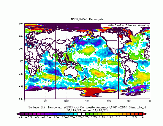
Ocean temp change over past 2 months
0 likes
-
TheProfessor
- Professional-Met
- Posts: 3506
- Age: 29
- Joined: Tue Dec 03, 2013 10:56 am
- Location: Wichita, Kansas
Re: Texas Winter 2020-2021
orangeblood wrote:With temps in the NorthEast Pacific cooling down like they have over the past few months, Going to be very difficult to get any sustained Ridge popping into Alaska (Negative EPO). It's Highly likely that Gulf of Alaska Lows will begin setting up shop in the NE Pacific, potentially flooding the lower 48 with Pacific air/keeping Arctic Air bottled up on Canada/Northern 1/2 of US...IMO, not looking good my friends.
Ocean temp change over past 2 months
https://www.weatherbell.com/images/imguploader/images/compday_BuyxqqO_ru.gif
This is expected for La Nina, if we had a full blow +PDO during a moderate to strong La Nina that would honestly be more concerning, even if it benefitted Texas.
0 likes
An alumnus of The Ohio State University.
Your local National Weather Service office is your best source for weather information.
Your local National Weather Service office is your best source for weather information.
-
orangeblood
- S2K Supporter
- Posts: 3895
- Joined: Tue Dec 15, 2009 6:14 pm
- Location: Fort Worth, TX
Re: Texas Winter 2020-2021
Well any hope of a moderate Negative EPO is dwindling daily.... could've been an amazing pattern paired with that Greenland ridge 

2 likes
Who is online
Users browsing this forum: Google [Bot], Iceresistance, TeamPlayersBlue and 75 guests