
this is pretty exciting, especially considering that it is fairly late breaking. Sadly, our local guys aren't even mentioning the possibility, and equally sadly, they are probably right. If there's ever an interesting weather event, we seem to be as far away from it as possible.
Oh well, for whomever gets this Christmas gift, please stay safe and enjoy!
Deep South Winterwx Discussion 2015-2016
Moderator: S2k Moderators
Forum rules
 The posts in this forum are NOT official forecast and should not be used as such. They are just the opinion of the poster and may or may not be backed by sound meteorological data. They are NOT endorsed by any professional institution or STORM2K.

The posts in this forum are NOT official forecast and should not be used as such. They are just the opinion of the poster and may or may not be backed by sound meteorological data. They are NOT endorsed by any professional institution or STORM2K.
-
Ivanhater

- Storm2k Moderator

- Posts: 11221
- Age: 39
- Joined: Fri Jul 01, 2005 8:25 am
- Location: Pensacola
Re: Deep South Winterwx thread: Euro shows historic snow storm
12z Euro bombing further west in the Gulf...Snow likely stretching down toward the Gulf coast!!
0 likes
Michael

Re: Deep South Winterwx thread: Euro shows historic snow storm
Ivanhater wrote:12z Euro bombing further west in the Gulf...Snow likely stretching down toward the Gulf coast!!
With such a consensus from the OP's, I'd put my money on snow. Now we start focusing on how much. This should be a crippling storm for the Carolinas to Se VA.
0 likes
The above post and any post by Ntxw is NOT an official forecast and should not be used as such. It is just the opinion of the poster and may or may not be backed by sound meteorological data. It is NOT endorsed by any professional institution including Storm2k. For official information, please refer to NWS products.
Help support Storm2K!
-
Ivanhater
- Storm2k Moderator
- Posts: 11221
- Age: 39
- Joined: Fri Jul 01, 2005 8:25 am
- Location: Pensacola
Re: Deep South Winterwx thread: Euro shows historic snow storm
Ntxw wrote:Ivanhater wrote:12z Euro bombing further west in the Gulf...Snow likely stretching down toward the Gulf coast!!
With such a consensus from the OP's, I'd put my money on snow. Now we start focusing on how much. This should be a crippling storm for the Carolinas to Se VA.
I'm trying to confirm snow amounts for my area Ntwx...The 24 hour maps are in no mans land when the low is in the Northern Gulf. Tonight should be a great map...can you tell?
0 likes
Michael
-
northjaxpro

- S2K Supporter

- Posts: 8900
- Joined: Mon Sep 27, 2010 11:21 am
- Location: Jacksonville, FL
Ivanhater, a farther west bombing Low would most likely pull colder air in faster behind the storm. Should that happen, I would think you would have a good chance to see light snow out there in the panhandle.
That scenario would also bring a good possibility of snow accumulations across South Alabama and Georgia as well.
That scenario would also bring a good possibility of snow accumulations across South Alabama and Georgia as well.
0 likes
NEVER, EVER SAY NEVER in the tropics and weather in general, and most importantly, with life itself!!
________________________________________________________________________________________
Fay 2008 Beryl 2012 Debby 2012 Colin 2016 Hermine 2016 Julia 2016 Matthew 2016 Irma 2017 Dorian 2019
________________________________________________________________________________________
Fay 2008 Beryl 2012 Debby 2012 Colin 2016 Hermine 2016 Julia 2016 Matthew 2016 Irma 2017 Dorian 2019
-
TeamPlayersBlue

- Category 5

- Posts: 3531
- Joined: Tue Feb 02, 2010 1:44 am
- Location: Denver/Applewood, CO
Yeah it looks like snow for the gulf states and likely somewhere in N Fla. Carolina will be slammed from this storm I dont see the "bombing" of the storm though. I see the development of the low in the gulf with lots of moisture though. Should be an interesting event no doubt.
0 likes
Personal Forecast Disclaimer:
The posts in this forum are NOT official forecast and should not be used as such. They are just the opinion of the poster and may or may not be backed by sound meteorological data. They are NOT endorsed by any professional institution or storm2k.org. For official information, please refer to the NHC and NWS products.
The posts in this forum are NOT official forecast and should not be used as such. They are just the opinion of the poster and may or may not be backed by sound meteorological data. They are NOT endorsed by any professional institution or storm2k.org. For official information, please refer to the NHC and NWS products.
-
Ivanhater
- Storm2k Moderator
- Posts: 11221
- Age: 39
- Joined: Fri Jul 01, 2005 8:25 am
- Location: Pensacola
Re:
northjaxpro wrote:Ivanhater, a farther west bombing Low would most likely pull colder air in faster behind the storm. Should that happen, I would think you would have a good chance to see light snow out there in the panhandle.
That scenario would also bring a good possibility of snow accumulations across South Alabama and Georgia as well.
Thanks! Last night's Euro showed up to 2 inches in NW Florida...Today has the low bombing further west which would show more snow..I just wish I had a visual!
0 likes
Michael
-
hurricanedude

- Military Member

- Posts: 1856
- Joined: Tue Oct 08, 2002 9:54 am
- Location: Virginia Beach, Virginia
- Contact:
Re: Deep South Winterwx thread: Euro shows historic snow storm
I live in Va Beach Va....when you say crippling snow in SE VA how much you talking about.....2 inches can cripple this area.....seriously though what amounts you thinking here?
0 likes
-
northjaxpro
- S2K Supporter
- Posts: 8900
- Joined: Mon Sep 27, 2010 11:21 am
- Location: Jacksonville, FL
Re: Deep South Winterwx thread: Euro shows historic snow storm
hurricanedude wrote:I live in Va Beach Va....when you say crippling snow in SE VA how much you talking about.....2 inches can cripple this area.....seriously though what amounts you thinking here?
It is too early to pinpoint what snowfall amounts will be up in that region right now. As always, the exact track and intensity of the storm will tell the tale with regards to just how much snow will accumulate in that region.
However, after reading through the AFDs from the NWS offices in Greenville/Spartanburg, SC and Raleigh, NC earlier this morning, the potential across the upstate region of SC, and the Foothills and Piedmont region of North Carolina to receive very significant snowfall is improving greatly.
We should know more with later model runs regarding the potential amounts of snowfall throughout the Carolinas and Mid Atlantic region probably within the next 24-36 hours.
0 likes
NEVER, EVER SAY NEVER in the tropics and weather in general, and most importantly, with life itself!!
________________________________________________________________________________________
Fay 2008 Beryl 2012 Debby 2012 Colin 2016 Hermine 2016 Julia 2016 Matthew 2016 Irma 2017 Dorian 2019
________________________________________________________________________________________
Fay 2008 Beryl 2012 Debby 2012 Colin 2016 Hermine 2016 Julia 2016 Matthew 2016 Irma 2017 Dorian 2019
-
georgia_tech_swagger

- Tropical Low

- Posts: 23
- Joined: Wed Dec 22, 2010 12:58 pm
Re: Deep South Winterwx thread: Euro shows historic snow storm
GSP NWS this morning:
GSP NWS a few minutes ago:
SHORT TERM /THURSDAY THROUGH SATURDAY NIGHT/...
AS OF 315 AM WEDNESDAY...SOME COMPELLING CHANGES IN MODEL GUIDANCE
POINT TO AN EVENT OF HISTORIC PROPORTIONS OVER THE PIEDMONT OF THE
CAROLINAS FOR CHRISTMAS DAY. THE ECMWF HAS BEEN REMARKABLY
CONSISTENT FOR THE PAST THREE DAYS WITH A SOUTHERN TRACK OF A
DEVELOPING LOW ACROSS THE DEEP SOUTH/NRN GULF COAST ON SATURDAY AND
SATURDAY NIGHT. THE GEM GLOBAL HAS MORE OR LESS BEEN FOLLOWING THAT
LEAD. FINALLY...ON THIS MODEL CYCLE...THE GFS...WHICH HAS BEEN A
FASTER NORTHERN HOLDOUT...IS ON BOARD WITH MOVING THE MAIN LOW
PRESSURE CENTER SLOWLY ALONG THE NORTHERN GULFMEX COAST ON CHRISTMAS
DAY. ON THE ONE HAND...THIS HAS RAISED CONFIDENCE THAT OUR MOSTLY
WHITE FORECAST FOR THE WEEKEND IS ON THE RIGHT TRACK. ON THE OTHER
HAND...CONFIDENCE IN THE GFS IS WEAKENED WITH ITS MAJOR DEPARTURE.
CONFIDENCE WILL GROW FURTHER IF THE OPERATIONAL GFS KEEPS WITH THE
SLOWER SOLUTIONS OF THE ECMWF AND GEM. NO MATTER WHICH MODEL HAS THE
BETTER TRACK...ALL THE MODELS NOW FEATURE PARTIAL THICKNESS VALUES
THAT FAVOR ALL SNOW OVER THE MAJORITY OF THE FORECAST AREA. FORECAST
SOUNDINGS LACK A WARM NOSE...SO IT LOOKS LIKE A RAIN/SNOW PROBLEM.
THE ONLY LOCATIONS THAT WOULD MIX OR CHANGEOVER TO RAIN WOULD BE
ROUGHLY SOUTH OF A LINE FROM HARTWELL TO ANDERSON AND LAURENS. TEMPS
SHOULD BE WELL BELOW THE GUIDANCE WITH THIS SCENARIO. WITH MUCH OF
THE PRECIP TYPE ISSUES OUT OF THE WAY...THE FORECAST BECOMES MORE OF
A TIMING AND QPF PROBLEM...THE GFS STILL BEING 6-12 HOURS FASTER
WITH ONSET BETWEEN MIDNIGHT AND SUNRISE CHRISTMAS DAY. THE SLOWER
ECMWF WOULD HAVE ONSET AFTER SUNRISE TO NOON SATURDAY. WITH THE GFS
ON BOARD...THE FORECAST IS BLEND OF THE GFS AND ECMWF FOR TIMING.
POP RAMPS UP FROM CHANCE TO LIKELY MAINLY SATURDAY MORNING AND
AFTERNOON. IN AN EFFORT TO REIN IN THE EXCITEMENT...THE QPF
GENERALLY FOLLOWS THE LOWER AMOUNTS ON THE GFS...WHICH STILL GIVES
US A UNIFORM 3-5 INCHES OF SNOW ACROSS THE FORECAST AREA SATURDAY
AND SATURDAY NIGHT...WITH THE EXCEPTION OF ELBERT...ABBEVILLE...AND
GREENWOOD COUNTIES THAT STAY ON THE WARM SIDE OF THE RAIN-SNOW LINE.
IT SHOULD BE NOTED THAT THE SLOWER AND STRONGER ECMWF HAS PLENTY OF
SUPPORT FOR ITS SOLUTION. IF THAT MODEL WERE TO VERIFY...WE WOULD
HAVE A MAJOR WINTER STORM MOVING UP THE COAST OF THE CAROLINAS
SATURDAY NIGHT AND SUNDAY...AND THE PIEDMONT WOULD STAND TO GET UP
TO DOUBLE WHAT IS CURRENTLY FORECAST. EITHER WAY...IF WE CONSIDER A
WHITE CHRISTMAS TO BE ONE INCH ACCUMULATION ON CHRISTMAS DAY...THAT
HAS NOT HAPPENED IN THE AREA FROM GREENVILLE (1963) TO CHARLOTTE
(1947) IN NEARLY 50 TO 60 YEARS. IF THIS FORECAST WORKS OUT...IT
COULD BE AN EVENT THAT WILL BE TALKED ABOUT FOR THE REST OF OUR
LIVES. THE POTENTIAL DOWNFALL WOULD BE IF THE SYSTEM SLOWS DOWN EVEN
MORE...IN WHICH CASE THE BULK OF THE SNOW WOULD FALL ON SUNDAY. STAY
TUNED!
GSP NWS a few minutes ago:
.SHORT TERM /THURSDAY NIGHT THROUGH SATURDAY/...
AS OF 225 PM WEDNESDAY...THE GUIDANCE IS STILL SUGGESTING A WHITE
CHRISTMAS. HOWEVER...THE GUIDANCE IS TRENDING SLOWER WITH ONSET.
THERE IS GOOD AGREEMENT THAT PRECIP...IF ANY...WILL BE MINIMAL FRI
NITE AND CONTAINED TO THE MTNS. THE NAM IS SLOWEST OF ALL KEEPING
MOST OF THE AREA DRY UNTIL SAT AFTERNOON...WHILE THE GEM GLOBAL AND
THE GFS ARE THE FASTEST TAPERING THINGS OFF ACROSS THE NW BY SAT
AFTERNOON. THE ECMWF...WHICH HAS BEEN REMARKABLY CONSISTENT THROUGH
FCST...HAS PRECIP OVER THE WRN CWFA SAT MORN AND ALL AREAS BY
AFTERNOON. THE ECMWF TIMING BEING IN THE MIDDLE OF THE OPERATIONAL
MDL PACK. THE GEM AND GFS STILL TRACK THE SFC LOW FARTHER SOUTH...
KEEPING BEST PRECIP FARTHER SOUTH AS WELL. THE SREF/NAM AND ECMWF
HAVE SIGNIFICANT PRECIP ACROSS THE CWFA IN A DEFORMATION ZONE AND
AREA OF UPPER DIVERGENCE. THE GUIDANCE IS ALL IN GOOD AGREEMENT WITH
THICKNESSES AND THERMAL PROFILES THAT SHOW SNOW WILL BY THE MAIN
P-TYPE OVER MOST OF THE FCST AREA. THERE IS STILL SOME QUESTION ON
HIGHS FOR SAT GIVEN THE SLOWER ONSET. THIS COULD ALLOW A MIX WITH OR
CHANGEOVER TO RAIN SOUTH OF I-85 IN THE UPSTATE AND NE GA. GIVEN THE
MDL VARIABILITY AND THE IMPORTANCE OF THIS FCST PERIOD...WILL KEEP
THE FCST GENERALLY AS IS EXCEPT WITH THE SLOWER ONSET FRI NITE GIVEN
THE AGREEMENT THERE. THE MDLS STILL SUGGEST A SNOWFALL OF SEVERAL
INCHES FROM CHRISTMAS DAY INTO THE EVENING. HOWEVER...THE BULK OF
THE ACCUMULATION COULD BE FROM LATE AFTERNOON INTO SUNDAY IF THE
SLOWING TREND CONTINUES.
IN THE MEAN TIME...FRIDAY WILL BE A QUIET WX DAY WITH RIDGING SFC
AND ALOFT. LOWS AND HIGHS WILL CONTINUE TO BE BELOW NORMAL.
&&
.LONG TERM /SATURDAY NIGHT THROUGH TUESDAY/...
AS OF 230 PM WEDNESDAY...ECMWF AND ECMWF ENSEMBLE MEAN APPEAR TO
HAVE TO MOST REASONABLE SOLUTIONS FOR THE EXTENDED PERIOD. DEEP H5
TROF AXIS MOVES OVER THE S MS VALLEY 00Z SUN WITH PRECIP CONTINUING
OUT AHEAD OF IT AS THE SFC LOW AND ASSOC COLD FRONT ROAR OUT ALONG
THE GULF COAST...ALL THE WAY TO THE ATLANTIC COAST BY 12Z SUN. AN
UPPER LOW IS EXPECTED TO DIG OVER THE TN AND OH VALLEYS SUN MRNG...
DEEPEN OVER THE CAROLINAS SUN AFTN...THEN HIT THE OUTER BANKS SUN
NIGHT. THE SYSTEM WILL BRING QUITE A BIT OF COLD AIR AND MOISTURE
WITH IT AND SNOW WILL CONTINUE OVER THE CWA SUN EVE BEFORE DOWNSLOPE
WINDS WRAPPING AROUND THE LOW INHIBIT PRECIP SE OF THE MTNS. STILL
HELD ON TO SLIGHT CHC POPS OVER THE PIEDMONT THRU SUN AFTN WHICH
SHOULD TURN TO RAIN BEFORE ENDING. AS THE LOW MOVES SLOWLY UP THE
COAST...NW FLOW SNOW WILL CONTINUE OVER THE MTNS SUN NIGHT AND
CONTINUE THRU MON BEFORE TAPERING OFF AND ENDING MON NIGHT. LOOK FOR
ANOTHER ROUND OF COLD TEMPS MON-TUE WITH HIGHS ABOUT 15 DEG BELOW
AVG. TEMPS WILL WARM TO WITHIN 5-8 DEG BELOW AVG WED AS A WEAK UPPER
RIDGE MOVES OVER THE AREA AND WEAK HIGH PRES RIDGES IN AT THE SFC.
0 likes
-
SunnyThoughts
- Category 5
- Posts: 2263
- Joined: Wed Jul 09, 2003 12:42 pm
- Location: Pensacola, Florida
Re: Deep South Winterwx thread: Euro shows historic snow storm
Looks to be possibly an epic storm setting up. EVERYONE with travel plans...or know of family or friends with travel plans..Give them a heads up. If all this comes to fruition, there are going to be ALOT of Holiday travelers stranded. Hopefully most will already have made it to their destination, I suppose the majority of the problems will be getting back home after Christmas. Good luck everybody...and stay safe.
0 likes
-
Ivanhater
- Storm2k Moderator
- Posts: 11221
- Age: 39
- Joined: Fri Jul 01, 2005 8:25 am
- Location: Pensacola
Re: Deep South Winterwx thread: Euro shows historic snow storm
Nws mobile/Pensacola now forecasting snow for Florida! This was this mornings package ..can't wait for this afternoons!

0 likes
Michael
-
Extremeweatherguy

- Category 5
- Posts: 11095
- Joined: Mon Oct 10, 2005 8:13 pm
- Location: Florida
The ECMWF scenario looks extreme for sure. I just took a peek at the precipitation and thickness maps on the accuweather pro site, and it definitely looks like there could be a mixing with or even a changeover to snow for parts of north Florida Saturday night into Sunday as moisture wraps around the west side of the low. The risk even appears to extend into north-central FL too according to the 12z run, but surface temps might be a tad too warm for anything but rain that far south. Either way, this certainly bears watching. The potential is definitely there for a big-ticket winter event across the southeast and up into new England this weekend and into early next week.
0 likes

Re: Deep South Winterwx thread: Euro shows historic snow storm
So is there a chance of snowfall along the mississippi coast? Actually I live about 45 minutes northeast of biloxi and about 45 minutes west of mobile. I'm keeping fingers crossed haha
0 likes
-
Ivanhater
- Storm2k Moderator
- Posts: 11221
- Age: 39
- Joined: Fri Jul 01, 2005 8:25 am
- Location: Pensacola
Re: Deep South Winterwx thread: Euro shows historic snow storm
Afternoon package from Mobile/Pensacola sucked. They literally summarized this extremely dynamic situation and possible historic storm into a small paragraph. The afternoon crew is not ready to bit yet. If the Euro holds strong tonight..they won't have a choice.
Tallahassee discussion is great on the other hand!
GFS SOLUTION WOULD BRING A ROUND OF SHOWERS/RAIN TO THE REGION FOR
THE SECOND HALF OF CHRISTMAS DAY INTO CHRISTMAS NIGHT...HOWEVER THE
QPF WILL BE ON THE LIGHT SIDE. ALSO THE GFS WOULD NOT BE IDEAL FOR
MUCH WRAP AROUND MOISTURE TO INTERACT WITH THE COLDER AIR SPILLING
IN FROM THE NORTH AND NORTHWEST. THIS SCENARIO WOULD ONLY PRESENT A
VERY SLIGHT CHANCE FOR A BRIEF CHANGEOVER TO FROZEN PRECIP OVER OUR
NORTHERN/NW ZONES. ECMWF SOLUTION WOULD SUGGEST A MORE DYNAMIC
SYSTEM AND HEAVIER PRECIP EVENT. THIS SOLUTION IS ALSO CONCERNING
SINCE A DEEPENING SYSTEM SHOULD LEAD TO A MORE DEFINED DEFORMATION
ZONE/FGEN PRECIP BAND ON THE BACKSIDE OF THE LOW. WITH NO LACK OF
COLD AIR BEHIND THIS SYSTEM...THE ECMWF SOLUTION WOULD SUGGEST A
BETTER POTENTIAL FOR SNOW ACROSS A LARGER PORTION OF THE FORECAST
AREA SATURDAY NIGHT AND INTO SUNDAY MORNING. STILL TOO EARLY...AND
CONFIDENCE A BIT LOW TO INCLUDE FROZEN PRECIP IN THE GRIDS...BUT IT
WILL NEED TO BE WATCHED CL
0 likes
Michael
-
SunnyThoughts
- Category 5
- Posts: 2263
- Joined: Wed Jul 09, 2003 12:42 pm
- Location: Pensacola, Florida
Re: Deep South Winterwx thread: Euro shows historic snow storm
Ivan/Michael you might like the looks of this. This is from Shelby WEather...take a look at the graphics! http://www.shelbyweather.blogspot.com/
0 likes
-
Ivanhater
- Storm2k Moderator
- Posts: 11221
- Age: 39
- Joined: Fri Jul 01, 2005 8:25 am
- Location: Pensacola
Re: Deep South Winterwx thread: Euro shows historic snow storm
SunnyThoughts wrote:Ivan/Michael you might like the looks of this. This is from Shelby WEather...take a look at the graphics! http://www.shelbyweather.blogspot.com/
And there is my visual I've been craving! Wow! This would be amazing
0 likes
Michael
-
WacoWx
- Category 2

- Posts: 692
- Joined: Mon Dec 28, 2009 4:14 pm
- Location: NOT Waco, TX ----> Dallas, TX
Re: Deep South Winterwx thread: Euro shows historic snow storm
Here in Central TX, they have increased the chance of precip from 50%-80&, as well as adding in t-storms. Our storm totals have increased from .3 in to up to isolated 2 inches. Very cold core with this sucker. I hope yall get a white Christmas over there! Better than my wet Christmas 
NATIONAL WEATHER SERVICE FORT WORTH TX
230 PM CST WED DEC 22 2010
.DISCUSSION...
THE HARD HITTING CALIFORNIA STORM SYSTEM WILL ARRIVE IN NORTH
TEXAS CHRISTMAS EVE DAY WITH SOME BADLY NEEDED RAINFALL FOR MUCH
OF THE REGION. COLD OVER THE HOLIDAY WEEKEND AND FIRST OF NEXT
WEEK...BUT WARMING TO AROUND NORMAL ON WEDNESDAY.
THE FOG AND DRIZZLE HAS BEEN REMOVED FROM THE FORECAST FOR LATE
TONIGHT/EARLY THURSDAY MORNING AS THE SETUP DOES NOT SEEM IDEA.
A VERY ENERGETIC UPPER LEVEL TROUGH WILL MOVE ACROSS THE SOUTHERN
ROCKIES TOMORROW AND INTO WEST TEXAS AS A CLOSE LOW ON FRIDAY. AS IT
MOVES INTO NORTH TEXAS THERE WILL BE A STRONG INTRUSION OF PV 1.5
THAT WILL KEEP THE CORE OF THE SYSTEM VERY COLD WHILE ITS OVER
THE CWA. AT THE SURFACE....A COLD FRONT CURRENTLY SOUTH OF THE
CWA TODAY WILL BEGIN TO LIFT NORTHWARD TOMORROW WITH A GOOD
MOISTURE SUPPLY AVAILABLE AS THE UPPER SYSTEM ARRIVES. ISENTROPIC
SURFACES 295-305 SHOW A FAIR GOOD WARM CONVEYOR SETUP AND THE
POTENTIAL FOR MODERATE LONG DURATION RAINS...ESPECIALLY EAST
THROUGH NORTH OF THE MID LEVEL CORE TRACK. ELEVATED THUNDERSTORMS
WILL BE INCREASING LIKELY ON FRIDAY DUE TO INCREASED INSTABILITY
AND COLD TEMPS ALOFT. THIS SYSTEM HAS THE POTENTIAL FOR UP TO 1
INCH OF RAINFALL WITH SOME ISOLATED TOTALS NEAR 2 INCHES WHERE
STORMS OCCUR. AS THE SYSTEM DEPARTS ON CHRISTMAS DAY...THERE
REMAINS A LOW POTENTIAL FOR SOME LIGHT WRAP- AROUND LIGHT RAIN
OVER THE SOUTHEAST COUNTIES. SMALL DIURNAL TEMPERATURES CHANGE ON
FRIDAY DUE TO THE CLOUDS AND RAIN.
COLD SURFACE HIGH PRESSURE WILL BUILD OVER NORTH TEXAS BEHIND THIS
SYSTEM...KEEPING TEMPS IN THE 40S TO AROUND 50 FROM CHRISTMAS DAY
THROUGH MONDAY. LOW TEMPS SUNDAY WILL RANGE FROM THE LOWER 20S OUT
WEST TO AROUND 30 IN THE SOUTHEAST...THEN IN THE 20S EVERYWHERE
MONDAY MORNING. LOWS WILL CLIMB TO AROUND FREEZING OVER THE
SOUTHWEST THIRD TUESDAY MORNING. WARMER TUESDAY AND WEDNESDAY AS
SOUTHEASTERLY FLOW RETURNS.
0 likes
Re: Deep South Winterwx thread: Euro shows historic snow storm
Ivanhater, I get mobile/pensacola news and they said there's 0 percent chance of snow from mobile south and only a 10 percent chance just north of there
0 likes
-
Ivanhater
- Storm2k Moderator
- Posts: 11221
- Age: 39
- Joined: Fri Jul 01, 2005 8:25 am
- Location: Pensacola
Re: Deep South Winterwx thread: Euro shows historic snow storm
bella_may wrote:Ivanhater, I get mobile/pensacola news and they said there's 0 percent chance of snow from mobile south and only a 10 percent chance just north of there
Lol. They are regurgitating the NWS discussion from this afternoon. They are not ready to bit yet, which is understandable. This set up is very rare, especially on Christmas. The Euro has not budged in days, and if it holds strong tonight, they will not have a choice but to start advertising snow.
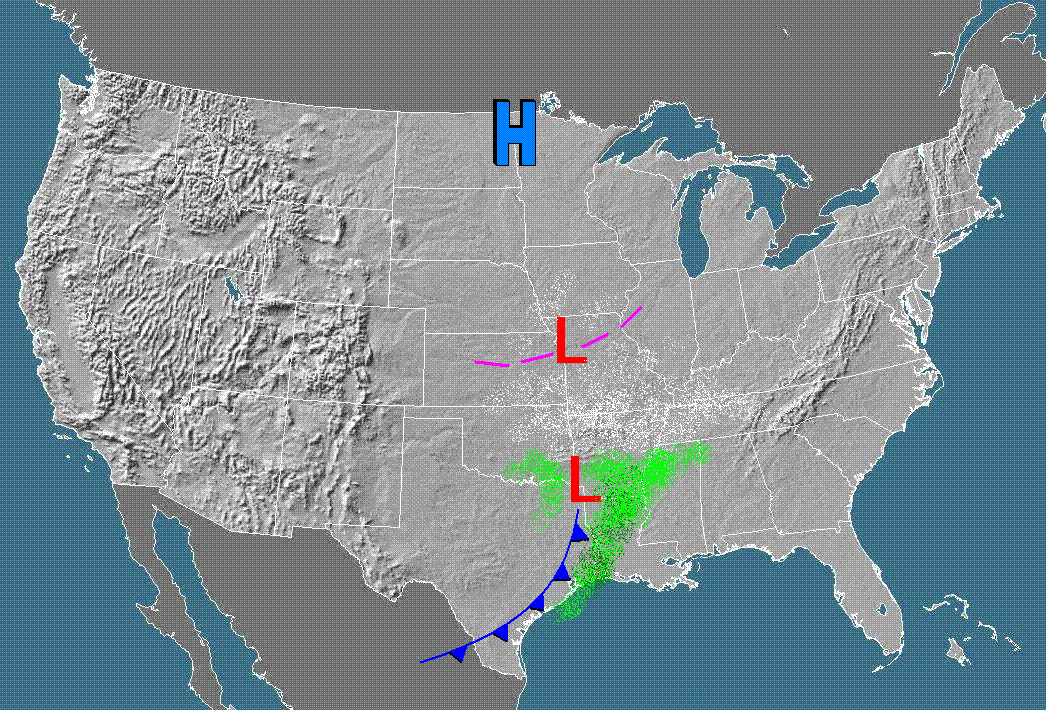
Here is a visual of the Euro which shows widespread snow for S. Alabama and NW Florida.
0 likes
Michael
Who is online
Users browsing this forum: No registered users and 79 guests