Texas Winter 2011-2012...
Moderator: S2k Moderators
Forum rules
 The posts in this forum are NOT official forecast and should not be used as such. They are just the opinion of the poster and may or may not be backed by sound meteorological data. They are NOT endorsed by any professional institution or STORM2K.

The posts in this forum are NOT official forecast and should not be used as such. They are just the opinion of the poster and may or may not be backed by sound meteorological data. They are NOT endorsed by any professional institution or STORM2K.
-
Palmer divide shadow
- Tropical Depression

- Posts: 54
- Joined: Thu Dec 29, 2011 11:15 am
- Location: Monument Colorado,but from Sugarland tx


Re: Re:
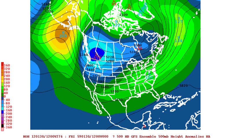
wxman57 wrote:Ntxw wrote:Hm, I don't know about you guys but 12z Euro should at least give wxman a bit of worrying to do! It has a lot of amplification and more cold up north compared to it's previous runs. If the eastern Canadian height rise happens as depicted by it and other models, any cold air that builds will likely head south rather than east! In short, It begins support for the GFS pattern change!
I saw that, but what the image doesn't show you is what's coming in from the west. I'm looking at a hemispheric 500mb heights loop of the 12Z Euro. There's a very deep low just off the map that is starting to suppress the ridge at 240 hrs.
I am by no means a met and you have forgotten more meteorology than I'll ever know. However, wouldn't the the low to the west of Alaska help shift the north Pacific ridge further east toward and eventually strattling the west coast? In fact, at 240h the mean trough is too far west to deliver any arctic air to anyone but the western US, but if that low pressure area moving in from west of Alaska can shift the north Pacific ridge further east, the mean trough may set up right across the central US, and perhaps give us something close to a McFarlane Signature beyond 240 hours as Ed has suggested. I know I'm grasping, but I'm trying to look on the bright side ("glass half full" as Ed says).
Of course, the model will probably not verify, but it sure is nice to dream.
0 likes
-
South Texas Storms

- Professional-Met

- Posts: 4255
- Joined: Thu Jun 24, 2010 12:28 am
- Location: Houston, TX
Re: Texas Winter 2011-2012...
Portastorm wrote:South Texas Storms wrote:I don't know about you guys, but I find the 12z models really depressing. The 0z CMC, Euro and GFS all agreed on around an inch of rain for SA and Austin on next Tuesday and now the 12zs show pretty much nothing. Man I am really depressed now. So much for starting 2012 rainfall on a good note. Sigh.
I wouldn't get too worked up over it. I still contend (and so does the venerable wxman57) that the models beyond 3-4 days are more unreliable this season due to some of the factors we've been talking about since November. And yes, this coming from the guy whose been yapping all morning about the GFS some 300 hours out.
That kinda makes me feel better Porta but I was so happy after seeing the 0z runs all showing heavy rainfall for South Central Texas next Tuesday. To see them all showing no rain on the 12z runs just made me very depressed this afternoon. I really hope the 0z runs come in very wet again.
I don't really care what the temperature is. I just want lots and lots of rain. I will be so happy once our drought finally ends. I really hope a lot of Texas cities set record rainfall totals this year. Does anyone else agree with me?
0 likes
-
wxman57

- Moderator-Pro Met

- Posts: 23170
- Age: 68
- Joined: Sat Jun 21, 2003 8:06 pm
- Location: Houston, TX (southwest)
Re: Texas Winter 2011-2012...
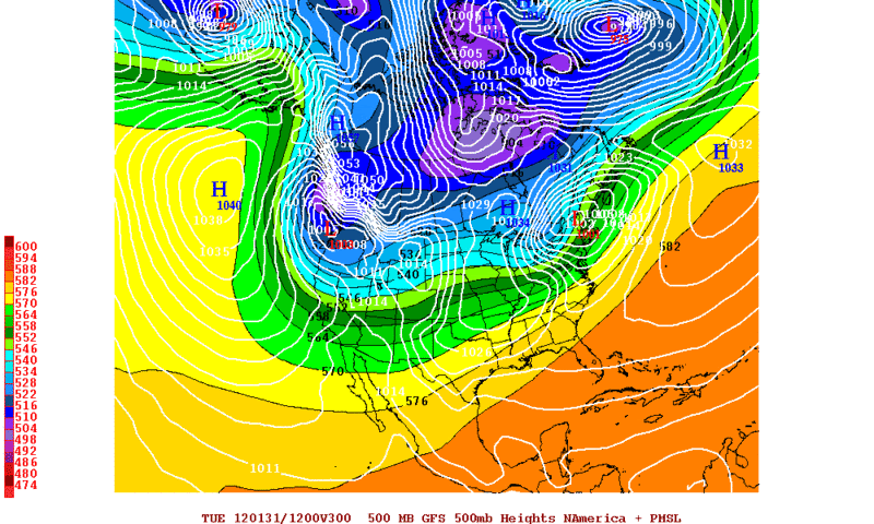
Palmer divide shadow wrote:Is that before or after the cold air starts pouring in?
That would be before.
0 likes
-
wxman57
- Moderator-Pro Met
- Posts: 23170
- Age: 68
- Joined: Sat Jun 21, 2003 8:06 pm
- Location: Houston, TX (southwest)
Re: Re:
Big O wrote:I am by no means a met and you have forgotten more meteorology than I'll ever know. However, wouldn't the the low to the west of Alaska help shift the north Pacific ridge further east toward and eventually strattling the west coast? In fact, at 240h the mean trough is too far west to deliver any arctic air to anyone but the western US, but if that low pressure area moving in from west of Alaska can shift the north Pacific ridge further east, the mean trough may set up right across the central US, and perhaps give us something close to a McFarlane Signature beyond 240 hours as Ed has suggested. I know I'm grasping, but I'm trying to look on the bright side ("glass half full" as Ed says).
Of course, the model will probably not verify, but it sure is nice to dream.
That's not what the Euro hemispheric 500mb loop is indicating. Deep upper low appears to be moving east into Alaska at 240 hrs.
We'll need to wait another 2-3 days at least to compare the Euro/Canadian with the GFS for this potential event.
0 likes

Re: Texas Winter 2011-2012...
If the Canadian blocking occurs and is strong enough I think its possible to keep the low wxman is talking about hung up near the Aleutians with amplitude. But as wxman said too far out to figure.
Edit: Meanwhile 18z GFS gives yet another solution for next week's system lol cutoff low deep into Mexico! Beyond that though once passed 200hrs the players are in motion.
Edit: Meanwhile 18z GFS gives yet another solution for next week's system lol cutoff low deep into Mexico! Beyond that though once passed 200hrs the players are in motion.
0 likes
The above post and any post by Ntxw is NOT an official forecast and should not be used as such. It is just the opinion of the poster and may or may not be backed by sound meteorological data. It is NOT endorsed by any professional institution including Storm2k. For official information, please refer to NWS products.
Help support Storm2K!
Re: Texas Winter 2011-2012...
I agree that the deep eastern low appears to be moving east toward Alaska, however isn't it possible that if you role the model forward past 240 hours, the east movement of the low stops before or near Alaska, thereby shifting the ridge off the US west coast to a position straddling the west coast?
0 likes
-
wxman57
- Moderator-Pro Met
- Posts: 23170
- Age: 68
- Joined: Sat Jun 21, 2003 8:06 pm
- Location: Houston, TX (southwest)
Re: Texas Winter 2011-2012...
Big O wrote:I agree that the deep eastern low appears to be moving east toward Alaska, however isn't it possible that if you role the model forward past 240 hours, the east movement of the low stops before or near Alaska, thereby shifting the ridge off the US west coast to a position straddling the west coast?
Could be, but that's not what the GFS was showing. Of course, the 18Z GFS doesn't predict an outbreak.
0 likes
-
Rgv20

- S2K Supporter

- Posts: 2466
- Age: 39
- Joined: Wed Jan 05, 2011 5:42 pm
- Location: Edinburg/McAllen Tx
Here we go again.....0zGFS forecasting 1055+mb High in NW Canada by the end of the month 
0 likes
The following post is NOT an official forecast and should not be used as such. It is just the opinion of the poster and may or may not be backed by sound meteorological data. It is NOT endorsed by any professional institution including storm2k.org For Official Information please refer to the NHC and NWS products.
Breaking News: Sources within PWC have tracked records that a certain warm monger met has booked a flight to an undisclosed Island location in the south Pacific (cough Tahiti cough) just in time for the start of February in order to escape the winter apocalypse of 2012.
Hey almost 2 days worth of long range GFS depicting a massive east Pacific ridge, mighty interesting if you ask me.
And this time the pattern screams look out below!
Hey almost 2 days worth of long range GFS depicting a massive east Pacific ridge, mighty interesting if you ask me.
Rgv20 wrote:Here we go again.....0zGFS forecasting 1055+mb High in NW Canada by the end of the month
And this time the pattern screams look out below!
0 likes
The above post and any post by Ntxw is NOT an official forecast and should not be used as such. It is just the opinion of the poster and may or may not be backed by sound meteorological data. It is NOT endorsed by any professional institution including Storm2k. For official information, please refer to NWS products.
Help support Storm2K!
Help support Storm2K!
-
Rgv20
- S2K Supporter
- Posts: 2466
- Age: 39
- Joined: Wed Jan 05, 2011 5:42 pm
- Location: Edinburg/McAllen Tx
From our favorite meteorologist Joe Bastardi....On table:Feb 2012 as nasty asDec 2010..worst case (3-4 wks from now longer term pattern has similarities to 1985 mid/late Jan cold wave)........
Edit:0zGFS Ensembles pretty much agree with the operational GFS on rising 500mb heights inching slowly to eastern Canada by the end of the month....Interesting days ahead for model watching
Edit:0zGFS Ensembles pretty much agree with the operational GFS on rising 500mb heights inching slowly to eastern Canada by the end of the month....Interesting days ahead for model watching
0 likes
The following post is NOT an official forecast and should not be used as such. It is just the opinion of the poster and may or may not be backed by sound meteorological data. It is NOT endorsed by any professional institution including storm2k.org For Official Information please refer to the NHC and NWS products.
Re: Texas Winter 2011-2012...
0z Canadian onboard with the epac ridge, doesnt extend as far but its shooting up a low to the Aleutians for amplification towards hr 240, vortex near hudson bay classic arctic outbreak look.
0 likes
The above post and any post by Ntxw is NOT an official forecast and should not be used as such. It is just the opinion of the poster and may or may not be backed by sound meteorological data. It is NOT endorsed by any professional institution including Storm2k. For official information, please refer to NWS products.
Help support Storm2K!
Help support Storm2K!
-
Portastorm

- Storm2k Moderator

- Posts: 9954
- Age: 63
- Joined: Fri Jul 11, 2003 9:16 am
- Location: Round Rock, TX
- Contact:
Re: Texas Winter 2011-2012...
Channeling my inner Emperor Palpatine as I make my only comment after viewing the "wintry" overnight model runs:
Everything is progressing as I have forseen ...

Uploaded with ImageShack.us
Everything is progressing as I have forseen ...

Uploaded with ImageShack.us
0 likes
Any forecasts under my name are to be taken with a grain of salt. Get your best forecasts from the National Weather Service and National Hurricane Center.
-
wxman57
- Moderator-Pro Met
- Posts: 23170
- Age: 68
- Joined: Sat Jun 21, 2003 8:06 pm
- Location: Houston, TX (southwest)
Re: Texas Winter 2011-2012...
Not so fast, Palpatine! I see little agreement in the long-range models, and even the GFS is all over the place in the 10-15 day range from run to run.
Besides, the force is with me!

Besides, the force is with me!
0 likes

Re: Texas Winter 2011-2012...
Been interesting to watch the battle between good and evil......I mean warm and cold on the board the past couple of weeks. I've had my snow (finally) so I'm happy either way.
Ultimately, mother nature will have the last laugh. Wouldn't it be odd though if we went the entire winter without just ONE arctic blast??? When was the last time that happened????
Ultimately, mother nature will have the last laugh. Wouldn't it be odd though if we went the entire winter without just ONE arctic blast??? When was the last time that happened????
0 likes
-
Portastorm
- Storm2k Moderator
- Posts: 9954
- Age: 63
- Joined: Fri Jul 11, 2003 9:16 am
- Location: Round Rock, TX
- Contact:
Re: Texas Winter 2011-2012...
Interesting blog piece this morning from Houston Chronicle science writer Eric Berger, who quotes ImpactWeather's Fred Schmude. Read on ...
http://blog.chron.com/sciguy/2012/01/a-mild-winter-so-far-will-we-escape-arctic-blasts-this-year/
http://blog.chron.com/sciguy/2012/01/a-mild-winter-so-far-will-we-escape-arctic-blasts-this-year/
0 likes
Any forecasts under my name are to be taken with a grain of salt. Get your best forecasts from the National Weather Service and National Hurricane Center.
Re: Texas Winter 2011-2012...
Portastorm wrote:Interesting blog piece this morning from Houston Chronicle science writer Eric Berger, who quotes ImpactWeather's Fred Schmude. Read on ...
http://blog.chron.com/sciguy/2012/01/a-mild-winter-so-far-will-we-escape-arctic-blasts-this-year/
To add some fuel to the fire (or should I say "ice"), take a gander at the possibilities alluded to by David Tolleris with Wxrisk.com:
http://www.wxrisk.com/2012/01/big-berth ... t-sisters/
0 likes
-
Portastorm
- Storm2k Moderator
- Posts: 9954
- Age: 63
- Joined: Fri Jul 11, 2003 9:16 am
- Location: Round Rock, TX
- Contact:
Re: Texas Winter 2011-2012...
Hmmm ... the 12z GFS now cuts off next week's upper low to our west but continues the late cycle trend of a deep, cold trough over the western US.
Maybe it's just far-sighted and we can have more confidence in that early February turn to winter!
Maybe it's just far-sighted and we can have more confidence in that early February turn to winter!
0 likes
Any forecasts under my name are to be taken with a grain of salt. Get your best forecasts from the National Weather Service and National Hurricane Center.
-
wxman57
- Moderator-Pro Met
- Posts: 23170
- Age: 68
- Joined: Sat Jun 21, 2003 8:06 pm
- Location: Houston, TX (southwest)
Re: Texas Winter 2011-2012...
Portastorm wrote:Hmmm ... the 12z GFS now cuts off next week's upper low to our west but continues the late cycle trend of a deep, cold trough over the western US.
Maybe it's just far-sighted and we can have more confidence in that early February turn to winter!
Yeah, that must be it - the GFS doesn't know what's going to happen 5-6 days from now but has the 15-16 day forecast pegged.
0 likes
Who is online
Users browsing this forum: CaptinCrunch, rylo7956 and 143 guests