Texas Winter 2014-2015
Moderator: S2k Moderators
Forum rules
 The posts in this forum are NOT official forecast and should not be used as such. They are just the opinion of the poster and may or may not be backed by sound meteorological data. They are NOT endorsed by any professional institution or STORM2K.

The posts in this forum are NOT official forecast and should not be used as such. They are just the opinion of the poster and may or may not be backed by sound meteorological data. They are NOT endorsed by any professional institution or STORM2K.
-
wxman57

- Moderator-Pro Met

- Posts: 23169
- Age: 68
- Joined: Sat Jun 21, 2003 8:06 pm
- Location: Houston, TX (southwest)
Re: Texas Winter 2014-2015
It appears that I am having at least some success in diverting the Arctic air away from east and southeast Texas. The thickness of the coldest air just wasn't enough to make it all the way across Texas. I think a part of the reason was the relative lack of snow cover to our north. The Arctic air just modified/thinned (depth-wise) too quickly. We may have had a greater snow cover to our north in mid November than we did this week.
0 likes
-
orangeblood
- S2K Supporter

- Posts: 3895
- Joined: Tue Dec 15, 2009 6:14 pm
- Location: Fort Worth, TX
Re: Texas Winter 2014-2015
wxman57 wrote:It appears that I am having at least some success in diverting the Arctic air away from east and southeast Texas. The thickness of the coldest air just wasn't enough to make it all the way across Texas. I think a part of the reason was the relative lack of snow cover to our north. The Arctic air just modified/thinned (depth-wise) too quickly. We may have had a greater snow cover to our north in mid November than we did this week.
Now I do think it may have been a factor, the snow pack depth was deeper this time around compared to November/Sun Angle lower....The wind direction/strength at all levels seems to be the #1 factor this time around, quite a bit more than I've realized in the past. Definitely need to note/document for future outbreaks.
Mid November Snowpack depth

Late December Snowpack depth

0 likes
-
Ralph's Weather
- S2K Supporter
- Posts: 3371
- Age: 38
- Joined: Fri Dec 13, 2013 11:55 am
- Location: Lindale, TX
- Contact:
-
TheProfessor

- Professional-Met

- Posts: 3506
- Age: 29
- Joined: Tue Dec 03, 2013 10:56 am
- Location: Wichita, Kansas
-
wxman57
- Moderator-Pro Met
- Posts: 23169
- Age: 68
- Joined: Sat Jun 21, 2003 8:06 pm
- Location: Houston, TX (southwest)
Re: Texas Winter 2014-2015
orangeblood wrote:Now I do think it may have been a factor, the snow pack depth was deeper this time around compared to November/Sun Angle lower....The wind direction/strength at all levels seems to be the #1 factor this time around, quite a bit more than I've realized in the past. Definitely need to note/document for future outbreaks...snip
Snow depth isn't as significant as coverage area. Coverage was greater in November than prior to this front's movement down the Plains. Upper winds aren't much of a factor. Depth of the cold air to start out with is a big factor.
0 likes
-
gboudx

- S2K Supporter
- Posts: 4090
- Joined: Thu Sep 04, 2003 1:39 pm
- Location: Rockwall, Tx but from Harvey, La
Re:
TheProfessor wrote::uarrow: Might be best to travel around that area of Texas, I wouldn't want to risk traveling on ice, especially your wife and new baby, and Congrats btw!
I don't think Ralph's wife is in NM, just family who want to be there for the blessed event.
Good luck Ralph! Forget everything you know about good sleep.
0 likes
-
weatherdude1108
- Category 5

- Posts: 4228
- Joined: Tue Dec 13, 2011 1:04 pm
- Location: Northwest Austin/Cedar Park, TX
Re:
ATCcane wrote:To add to the above, west of I35 and north of I10 it's still quite cold. I'm sitting here on the northwest side of austin at 39 and we haven't been out of the 30s on my weather station for quite a while. You don't have to go very far west of here to get into the mid and lower 30s and in west Texas and eastern New Mexico it's still in the 20s.
The next couple weeks are still looking chilly on he last few model runs. It'll be interesting to see how it plays out.
I'm in South Cedar Park and finally hit 40 around noon, after a couple days straight in the 30s.
0 likes
-
TheProfessor
- Professional-Met
- Posts: 3506
- Age: 29
- Joined: Tue Dec 03, 2013 10:56 am
- Location: Wichita, Kansas
Re: Re:
gboudx wrote:TheProfessor wrote::uarrow: Might be best to travel around that area of Texas, I wouldn't want to risk traveling on ice, especially your wife and new baby, and Congrats btw!
I don't think Ralph's wife is in NM, just family who want to be there for the blessed event.
Good luck Ralph! Forget everything you know about good sleep.
Oh ok, I thought he was in NM lol, I'd still have his family avoid that area though if it's as bad as I have been hearing.
0 likes
An alumnus of The Ohio State University.
Your local National Weather Service office is your best source for weather information.
Your local National Weather Service office is your best source for weather information.
-
orangeblood
- S2K Supporter
- Posts: 3895
- Joined: Tue Dec 15, 2009 6:14 pm
- Location: Fort Worth, TX
Re: Texas Winter 2014-2015
wxman57 wrote:orangeblood wrote:Now I do think it may have been a factor, the snow pack depth was deeper this time around compared to November/Sun Angle lower....The wind direction/strength at all levels seems to be the #1 factor this time around, quite a bit more than I've realized in the past. Definitely need to note/document for future outbreaks...snip
Snow depth isn't as significant as coverage area. Coverage was greater in November than prior to this front's movement down the Plains. Upper winds aren't much of a factor. Depth of the cold air to start out with is a big factor.
Gotcha, but considering the strength of the HP and record cold Temps across Colorado/Nebraska isn't it safe to assume it was a fairly deep airmass? And aren't upper level winds the variable that could erode the cold air from the top down? The southwest flow seem to prevent this HP from spreading too far south and east, it appeared to hug the path of least resistance (due to the southwest winds aloft), which was the leeside of the Rockies
0 likes
-
Ralph's Weather
- S2K Supporter
- Posts: 3371
- Age: 38
- Joined: Fri Dec 13, 2013 11:55 am
- Location: Lindale, TX
- Contact:
-
Texas Snowman

- Storm2k Moderator

- Posts: 6197
- Joined: Fri Jan 25, 2008 11:29 am
- Location: Denison, Texas
Re: Texas Winter 2014-2015
No snow or sleet in Denison out of this, but we did have some freezing rain yesterday morning that coated trees, cars and a bridge or two. Even apparently caused a spin-out that knocked down a traffic sign.
Better yet, we've had light, moderate and even heavy rainfall off and on again over the past 24+ hours with temps in the mid 30s. It just thundered a few times and there is more rain to come. Last time I checked the FW NWS radar precip map, we've had more than an inch of soaking rains here in Denison. Front and back yards are soaked and big, deep puddles are plentiful.
Not a white Christmas or New Year's Day this year, but with a fire in the fireplace, the kiddos home from school and a warm, cozy feeling all around, I'll take it.
0 likes
The above post and any post by Texas Snowman is NOT an official forecast and should not be used as such. It is just the opinion of the poster and may or may not be backed by sound meteorological data. It is NOT endorsed by any professional institution including storm2k.org. For official information, please refer to NWS products.
-
Lagreeneyes03
- Category 2

- Posts: 607
- Joined: Mon Dec 09, 2013 10:53 am
- Location: Luxurious Lake Grapevine
Re:
CaptinCrunch wrote:If you didn't see any freezing precip this go around don't worry, January looks to be locked and loaded for plenty of winter fun and surprises. The forecast for NTX over the next 10 days looks to keep highs only in the mid to lower 40's.
Precip though? It seems to be, from what I've seen, modeled as pretty dry. Unless I'm missing something.
0 likes
I'm a Princess, not a forecaster.
-
TheProfessor
- Professional-Met
- Posts: 3506
- Age: 29
- Joined: Tue Dec 03, 2013 10:56 am
- Location: Wichita, Kansas
-
gboudx
- S2K Supporter
- Posts: 4090
- Joined: Thu Sep 04, 2003 1:39 pm
- Location: Rockwall, Tx but from Harvey, La
Re:
TheProfessor wrote:Getting a nice cold rain here, it may not be as exciting or fun as snow, but it is a billion times better than being dry slotted.
Steve McCauley posted this forecast radar for overnight rain. Definitely not dry slotted.
https://www.facebook.com/wfaa.steve.mcc ... 93/?type=1
0 likes
-
orangeblood
- S2K Supporter
- Posts: 3895
- Joined: Tue Dec 15, 2009 6:14 pm
- Location: Fort Worth, TX
Re:
gpsnowman wrote:It's awfully quiet in here today. Nothing next week to talk about? Or is everyone still hungover from New Years?
Late next week looks really interesting, IMO....models will have issues handling the massive height rise behind the 1st Arctic High Next week, might see a system form in between the modified 1st arctic high and the second high coming down late next week.
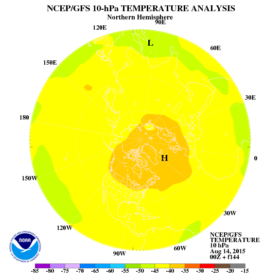
Also, check out the Stratospheric Warming forecast to occur over the next week around Arctic Circle/Greenland...in theory, this should crater the AO, create blocking in the high latitudes and force cold/storms much further south. Last nights Euro Weeklies have this for later this month - showing up in weeks 3 & 4.
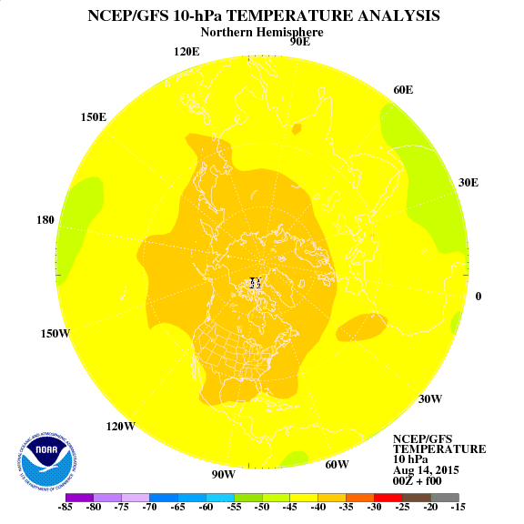
Current temps at the 10 hPa level, notice the cold Polar Vortex over Greenland
Then notice the incredible warming in the same area at hour 144, splitting the Polar Vortex

0 likes
-
Rgv20

- S2K Supporter
- Posts: 2466
- Age: 39
- Joined: Wed Jan 05, 2011 5:42 pm
- Location: Edinburg/McAllen Tx
Been stuck in the 40s with light drizzle for 3 straight days! Looks like today high is going to be 47 and is not forecast to break 70 at least for the next 5 days! I really have not taken a good look on the long range models as family and nieces don't really give me a chance! lol Going to take a good look at the models this weekend.
0 likes
The following post is NOT an official forecast and should not be used as such. It is just the opinion of the poster and may or may not be backed by sound meteorological data. It is NOT endorsed by any professional institution including storm2k.org For Official Information please refer to the NHC and NWS products.
Re: Texas Winter 2014-2015
The 500mb pattern forecast (on the ensembles and the op guidance) looks more like the cold will be displaced to the East, with TX getting modified shots of cold air. Has time to change though.
0 likes
Who is online
Users browsing this forum: Harp.1 and 141 guests