Texas Winter 2011-2012...
Moderator: S2k Moderators
Forum rules
 The posts in this forum are NOT official forecast and should not be used as such. They are just the opinion of the poster and may or may not be backed by sound meteorological data. They are NOT endorsed by any professional institution or STORM2K.

The posts in this forum are NOT official forecast and should not be used as such. They are just the opinion of the poster and may or may not be backed by sound meteorological data. They are NOT endorsed by any professional institution or STORM2K.
-
MGC

- S2K Supporter

- Posts: 5940
- Joined: Sun Mar 23, 2003 9:05 pm
- Location: Pass Christian MS, or what is left.
Re: Texas Winter 2011-2012...
I was over in New Orleans in November and picked up a Voodoo Doll. I hate winter so I decided to try and thwart winter this year by sticking a few needles in it every time it got cold. The few times the long range GFS has forecast an arctic outbreak in the long range I throw the doll in the oven and warm it up....presto, no cold air. Looks like an early spring to me....some trees are starting to bloom.....MGC
0 likes
-
wxman57

- Moderator-Pro Met

- Posts: 23170
- Age: 68
- Joined: Sat Jun 21, 2003 8:06 pm
- Location: Houston, TX (southwest)
Re: Texas Winter 2011-2012...
MGC wrote:I was over in New Orleans in November and picked up a Voodoo Doll. I hate winter so I decided to try and thwart winter this year by sticking a few needles in it every time it got cold. The few times the long range GFS has forecast an arctic outbreak in the long range I throw the doll in the oven and warm it up....presto, no cold air. Looks like an early spring to me....some trees are starting to bloom.....MGC
Funny you should mention that. I have just such a voodoo doll, also picked up in New Orleans, sitting atop my desk:

0 likes
-
Portastorm

- Storm2k Moderator

- Posts: 9954
- Age: 63
- Joined: Fri Jul 11, 2003 9:16 am
- Location: Round Rock, TX
- Contact:
Re: Texas Winter 2011-2012...
Given these disturbing and disappointing admissions from MGC and wxman57, I may have to pull the pin OUT of my hurricane season voodoo doll!
0 likes
Any forecasts under my name are to be taken with a grain of salt. Get your best forecasts from the National Weather Service and National Hurricane Center.


I wouldn't mind if it never got brutally cold, I just want cold enough to snow (though if it doesn't snow and gets cold might as well go for records!). If wxman gets 3-4 (10+ if you count this season) months of intense heat and almost guaranteed a 100+ day bike ride, can't we be given one day to throw snowballs at him?! Is that unfair to ask mother nature??? 
Pesky Alaskan low just won't budge, any cold that comes looks quick and transient for now. I'm hoping for a wet summer, these stage 3 restrictions is starting to hurt, and there's been talks about raising water prices for the city.
Pesky Alaskan low just won't budge, any cold that comes looks quick and transient for now. I'm hoping for a wet summer, these stage 3 restrictions is starting to hurt, and there's been talks about raising water prices for the city.
0 likes
The above post and any post by Ntxw is NOT an official forecast and should not be used as such. It is just the opinion of the poster and may or may not be backed by sound meteorological data. It is NOT endorsed by any professional institution including Storm2k. For official information, please refer to NWS products.
Help support Storm2K!
-
gboudx

- S2K Supporter
- Posts: 4090
- Joined: Thu Sep 04, 2003 1:39 pm
- Location: Rockwall, Tx but from Harvey, La
Re: Texas Winter 2011-2012...
Agua wrote:Going to buy MGC and 57 dolls.
Get a gris-gris instead. Much more powerful than some commercialized doll any tourist can buy in the Vieux Carre. Be sure to take it to the gravesite of Marie Laveau and chant for the gris-gris.
0 likes


Re: Texas Winter 2011-2012...
The relatively strong belt of westerlies will relax eventually. Question is, will it be in February or March? Then whatever cold air there still is will come down either on our side of the world, Europe/Asia, or both. I don't think it will be warm all the way through spring.
0 likes
Re: Texas Winter 2011-2012...
I'm hoping for one good cold blast to kill some bugs before spring.
0 likes
-
somethingfunny

- ChatStaff

- Posts: 3926
- Age: 37
- Joined: Thu May 31, 2007 10:30 pm
- Location: McKinney, Texas
The longer this winter drags on, the happier I am that I chose to pull that all-nighter chase to Decatur on December 3rd/4th. 
0 likes
I am not a meteorologist, and any posts made by me are not official forecasts or to be interpreted as being intelligent. These posts are just my opinions and are probably silly opinions.
-
MGC
- S2K Supporter
- Posts: 5940
- Joined: Sun Mar 23, 2003 9:05 pm
- Location: Pass Christian MS, or what is left.
Re: Texas Winter 2011-2012...
My car is covered with pollen this morning....the gnats are out looking for blood. Sure sign winter is done. Glad to see 57 and I employ identical forcasting methods......MGC
0 likes
-
AggieSpirit
- Tropical Storm

- Posts: 223
- Joined: Sat Nov 29, 2003 5:18 am
- Location: Midlothian, TX
Re: Texas Winter 2011-2012...
1.47 inches in my rain gauge as of 6:50 PM - with heavy rain still falling. This is about a 4 hour total since it started. Nice!
0 likes
-
AggieSpirit
- Tropical Storm
- Posts: 223
- Joined: Sat Nov 29, 2003 5:18 am
- Location: Midlothian, TX
Re: Texas Winter 2011-2012...
Radar shows a 2.7 inches an hour rainfall rate over my house in southern Midlothian right now. This may make a dent in all the low ponds I fish around here - some of them dried up completely and lost all fish 
0 likes
-
BrokenGlassRepublicn
- Category 1

- Posts: 483
- Joined: Sun Nov 20, 2011 8:07 pm
- Location: Richardson, Texas
Re: Texas Winter 2011-2012...
AggieSpirit wrote:1.47 inches in my rain gauge as of 6:50 PM - with heavy rain still falling. This is about a 4 hour total since it started. Nice!
A very disappointing .33 in my rain guage here in Richardson as of 8.07 pm. New rain guage, maybe it's broken.
0 likes
-
Rgv20

- S2K Supporter
- Posts: 2466
- Age: 39
- Joined: Wed Jan 05, 2011 5:42 pm
- Location: Edinburg/McAllen Tx
It looks like most of the activity should stay north of my area..
SPECIAL WEATHER STATEMENT
NATIONAL WEATHER SERVICE BROWNSVILLE TX
832 PM CST TUE JAN 24 2012
TXZ248>251-250645-
ZAPATA-JIM HOGG-BROOKS-KENEDY-
INCLUDING THE CITIES OF...ZAPATA...HEBBRONVILLE...FALFURRIAS...
SARITA
832 PM CST TUE JAN 24 2012
...SOME POTENTIAL FOR STRONG TO POSSIBLY SEVERE THUNDERSTORMS
TONIGHT OVER PORTIONS OF THE RIO GRANDE PLAINS...
A STRONG STORM SYSTEM...MOVING IN FROM THE WEST...IS EXPECTED TO
TRIGGER THUNDERSTORMS TONIGHT OVER THE BIG BEND AND HILL COUNTRY
OF TEXAS. THOSE STORMS ARE EXPECTED TO FORM A SQUALL LINE AND
GENERALLY MOVE EAST TO SOUTHEAST.
WARM AIR ALOFT MAY PREVENT STORMS FROM PUSHING AS FAR SOUTH AS
ZAPATA...HEBBRONVILLE...AND FALFURRIAS...BUT IF STORMS DEVELOP
THEY WILL BE CAPABLE OF GUSTY...AND POTENTIALLY DAMAGING WINDS
OF 50 TO 60 MPH...AND HAIL OF ONE HALF INCH TO UP TO ONE INCH
IN DIAMETER.
THE MOST LIKELY TIME FOR STORMS WOULD BE BETWEEN MIDNIGHT AND 600
AM. MONITOR NOAA WEATHER RADIO...WEATHER.GOV...AND LOCAL MEDIA FOR
UPDATES.
$$
JGG/GB
0 likes
The following post is NOT an official forecast and should not be used as such. It is just the opinion of the poster and may or may not be backed by sound meteorological data. It is NOT endorsed by any professional institution including storm2k.org For Official Information please refer to the NHC and NWS products.
-
gboudx
- S2K Supporter
- Posts: 4090
- Joined: Thu Sep 04, 2003 1:39 pm
- Location: Rockwall, Tx but from Harvey, La
Re: Texas Winter 2011-2012...
BrokenGlassRepublicn wrote:AggieSpirit wrote:1.47 inches in my rain gauge as of 6:50 PM - with heavy rain still falling. This is about a 4 hour total since it started. Nice!
A very disappointing .33 in my rain guage here in Richardson as of 8.07 pm. New rain guage, maybe it's broken.
You must have more than that by now. I haven't checked my rain gauge, but radar estimate 2+ here in Rockwall. Maybe Lavon will get some runoff this time.
0 likes
-
AggieSpirit
- Tropical Storm
- Posts: 223
- Joined: Sat Nov 29, 2003 5:18 am
- Location: Midlothian, TX
Re: Texas Winter 2011-2012...
3.21 inches of Rain in last 6 hours at my house! Putting a decent dink in the drought.
0 likes
-
AggieSpirit
- Tropical Storm
- Posts: 223
- Joined: Sat Nov 29, 2003 5:18 am
- Location: Midlothian, TX
Re: Texas Winter 2011-2012...
Last few frames show some back building storms near Commanche, Stephenville, and Granbury.
By the way - there is a swath of 5 inch rain totals between Commanche and Stephenville - with a small area of 6 inches + (per WFAA rainfall estimates radar). Some of those areas were amongst the hardest hit in the drought last summer. The ranchers have to be happy with the rise and probably some of the filling of formerly parched stock tanks.
Some places in Ellis County have gotten 4 inches as well.
I'm still down about no snow or ice so far this winter, but if we can get 3 or 4 more dumps of rain like this heading into Spring, it will be most beneficial.
0 likes
-
BrokenGlassRepublicn
- Category 1
- Posts: 483
- Joined: Sun Nov 20, 2011 8:07 pm
- Location: Richardson, Texas
Re: Texas Winter 2011-2012...
gboudx wrote:BrokenGlassRepublicn wrote:AggieSpirit wrote:1.47 inches in my rain gauge as of 6:50 PM - with heavy rain still falling. This is about a 4 hour total since it started. Nice!
A very disappointing .33 in my rain guage here in Richardson as of 8.07 pm. New rain guage, maybe it's broken.
You must have more than that by now. I haven't checked my rain gauge, but radar estimate 2+ here in Rockwall. Maybe Lavon will get some runoff this time.
User error. New rain guage has settings for last hour, last 24 hours, last week, last year. Didn't realize I was set to the last hour setting. I now have 1.45 in the last 24 hours.
0 likes
-
Rgv20
- S2K Supporter
- Posts: 2466
- Age: 39
- Joined: Wed Jan 05, 2011 5:42 pm
- Location: Edinburg/McAllen Tx
Let me double check the calender....yep its January! 
 ++
++
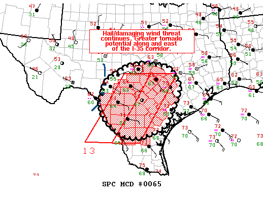
MESOSCALE DISCUSSION 0065
NWS STORM PREDICTION CENTER NORMAN OK
1134 PM CST TUE JAN 24 2012
AREAS AFFECTED...EDWARDS PLATEAU...HILL COUNTRY...S-CNTRL TX
CONCERNING...TORNADO WATCH 13...
VALID 250534Z - 250630Z
THE SEVERE WEATHER THREAT FOR TORNADO WATCH 13 CONTINUES.
PRIMARILY A SEVERE HAIL/DAMAGING WIND THREAT EXISTS WITH DEVELOPING
LINEAR MCS ALONG AND IMMEDIATELY W OF WW 13 OVER THE EDWARDS
PLATEAU. ADDITIONAL TSTMS SHOULD STRENGTHEN ACROSS S-CNTRL TX NEAR
LRD THROUGH EARLY MORNING...AND WOULD POSE A MORE SUBSTANTIAL
HAIL/TORNADO RISK.
WELL-ADVERTISED LINEAR MCS INVOF EDWARDS/KINNEY COUNTIES SHOULD
CONTINUE TO EXPAND E/NEWD ACROSS THE EDWARDS PLATEAU/HILL COUNTRY
WITHIN A ZONE OF FOCUSED ASCENT DOWNSTREAM OF MID-LEVEL IMPULSE
CENTERED OVER FAR W TX. RECENT SURFACE ANALYSES INDICATE THAT THIS
CLUSTER HAS REMAINED LARGELY POST-FRONTAL THUS FAR...PRIMARILY
POSING A SEVERE HAIL THREAT. AS ASCENT OVERSPREADS THE BROADER WARM
SECTOR...ADDITIONAL DEVELOPMENT ALONG/JUST AHEAD OF THE SURFACE
FRONT APPEARS PROBABLE...YIELDING A MIX OF ISOLATED SEVERE
HAIL/DAMAGING WIND THREATS AND PERHAPS A BRIEF TORNADO.
MID-LEVEL CONVECTION HAS BEEN INCREASING FARTHER SE TOWARDS
LRD...WITH INCIPIENT TSTM DEVELOPMENT APPEARING TO BE UNDERWAY.
GIVEN A MUCH BROADER WARM/MOIST SECTOR ALONG WITH STRONG SLYS AOA 30
KT ALONG AND E OF THE I-35 CORRIDOR...THIS SETUP SHOULD BE FAVORABLE
FOR SUPERCELLS CAPABLE OF PRODUCING TORNADOES AND LARGE HAIL.
..GRAMS.. 01/25/2012
ATTN...WFO...HGX...FWD...CRP...EWX...SJT...
LAT...LON 30040044 30320025 30889925 31039840 30879710 30569673
30289667 29929646 29339663 28239720 27999753 27719823
27629847 27629901 27669934 27829968 28380039 29120073
30040044
++MESOSCALE DISCUSSION 0065
NWS STORM PREDICTION CENTER NORMAN OK
1134 PM CST TUE JAN 24 2012
AREAS AFFECTED...EDWARDS PLATEAU...HILL COUNTRY...S-CNTRL TX
CONCERNING...TORNADO WATCH 13...
VALID 250534Z - 250630Z
THE SEVERE WEATHER THREAT FOR TORNADO WATCH 13 CONTINUES.
PRIMARILY A SEVERE HAIL/DAMAGING WIND THREAT EXISTS WITH DEVELOPING
LINEAR MCS ALONG AND IMMEDIATELY W OF WW 13 OVER THE EDWARDS
PLATEAU. ADDITIONAL TSTMS SHOULD STRENGTHEN ACROSS S-CNTRL TX NEAR
LRD THROUGH EARLY MORNING...AND WOULD POSE A MORE SUBSTANTIAL
HAIL/TORNADO RISK.
WELL-ADVERTISED LINEAR MCS INVOF EDWARDS/KINNEY COUNTIES SHOULD
CONTINUE TO EXPAND E/NEWD ACROSS THE EDWARDS PLATEAU/HILL COUNTRY
WITHIN A ZONE OF FOCUSED ASCENT DOWNSTREAM OF MID-LEVEL IMPULSE
CENTERED OVER FAR W TX. RECENT SURFACE ANALYSES INDICATE THAT THIS
CLUSTER HAS REMAINED LARGELY POST-FRONTAL THUS FAR...PRIMARILY
POSING A SEVERE HAIL THREAT. AS ASCENT OVERSPREADS THE BROADER WARM
SECTOR...ADDITIONAL DEVELOPMENT ALONG/JUST AHEAD OF THE SURFACE
FRONT APPEARS PROBABLE...YIELDING A MIX OF ISOLATED SEVERE
HAIL/DAMAGING WIND THREATS AND PERHAPS A BRIEF TORNADO.
MID-LEVEL CONVECTION HAS BEEN INCREASING FARTHER SE TOWARDS
LRD...WITH INCIPIENT TSTM DEVELOPMENT APPEARING TO BE UNDERWAY.
GIVEN A MUCH BROADER WARM/MOIST SECTOR ALONG WITH STRONG SLYS AOA 30
KT ALONG AND E OF THE I-35 CORRIDOR...THIS SETUP SHOULD BE FAVORABLE
FOR SUPERCELLS CAPABLE OF PRODUCING TORNADOES AND LARGE HAIL.
..GRAMS.. 01/25/2012
ATTN...WFO...HGX...FWD...CRP...EWX...SJT...
LAT...LON 30040044 30320025 30889925 31039840 30879710 30569673
30289667 29929646 29339663 28239720 27999753 27719823
27629847 27629901 27669934 27829968 28380039 29120073
30040044
0 likes
The following post is NOT an official forecast and should not be used as such. It is just the opinion of the poster and may or may not be backed by sound meteorological data. It is NOT endorsed by any professional institution including storm2k.org For Official Information please refer to the NHC and NWS products.
-
somethingfunny
- ChatStaff
- Posts: 3926
- Age: 37
- Joined: Thu May 31, 2007 10:30 pm
- Location: McKinney, Texas
Driving around Mesquite all night at work was brutal.  I'm grateful for the rain God, but you know I don't get off work until 10!
0 likes
I am not a meteorologist, and any posts made by me are not official forecasts or to be interpreted as being intelligent. These posts are just my opinions and are probably silly opinions.
Who is online
Users browsing this forum: Google [Bot], SnowyOwl31, Stratton23, wxman22 and 215 guests