Texas Winter 2014-2015
Moderator: S2k Moderators
Forum rules
 The posts in this forum are NOT official forecast and should not be used as such. They are just the opinion of the poster and may or may not be backed by sound meteorological data. They are NOT endorsed by any professional institution or STORM2K.

The posts in this forum are NOT official forecast and should not be used as such. They are just the opinion of the poster and may or may not be backed by sound meteorological data. They are NOT endorsed by any professional institution or STORM2K.
-
wxman22

- Category 5

- Posts: 1826
- Joined: Mon Jan 30, 2006 12:39 am
- Location: Wichita Falls, TX
- Contact:
Re: Texas Winter 2014-2015
Latest run of the cmc actually does show a majority of southeast Texas with frozen precipitation fwiw.
0 likes
-
Portastorm

- Storm2k Moderator

- Posts: 9954
- Age: 63
- Joined: Fri Jul 11, 2003 9:16 am
- Location: Round Rock, TX
- Contact:
Re: Texas Winter 2014-2015
wxman22 wrote:Latest run of the cmc actually does show a majority of southeast Texas with frozen precipitation fwiw.
My bad ... you're absolutely right wxman22. Thanks for catching that. I've not been terribly impressed with the CMC's accuracy but it's not always off the mark. Yet another reason why I wouldn't - at this point - rule out the possibility of wintry precip in SE Texas.
0 likes
Any forecasts under my name are to be taken with a grain of salt. Get your best forecasts from the National Weather Service and National Hurricane Center.

Hm so several Arctic blasts, one after another with "some" moderating in between progressively colder each blast than before? Sounds like 1977-1978 doesn't it? Of course on January 8th 1978 it got to almost 80! After a very warm December with a day almost reaching 90 in some spots! If you think about it pretty big contrasts that winter. We didn't have that this year. Just need to crank up that snow machine as did later that month.
0 likes
The above post and any post by Ntxw is NOT an official forecast and should not be used as such. It is just the opinion of the poster and may or may not be backed by sound meteorological data. It is NOT endorsed by any professional institution including Storm2k. For official information, please refer to NWS products.
Help support Storm2K!
-
Portastorm
- Storm2k Moderator
- Posts: 9954
- Age: 63
- Joined: Fri Jul 11, 2003 9:16 am
- Location: Round Rock, TX
- Contact:
One thing I've noticed already this morning and that's the 12z NAM-12 already developing some light moisture in south Texas on Wednesday. Granted, the NAM is frequently too bullish on moisture/QPF, but it will be something to watch.
0 likes
Any forecasts under my name are to be taken with a grain of salt. Get your best forecasts from the National Weather Service and National Hurricane Center.

Re: Texas Winter 2014-2015
wxman22 wrote:Latest run of the cmc actually does show a majority of southeast Texas with frozen precipitation fwiw.
I have learned to compare the CMC model to Weird Al Yankovic. Yes, it can sing, it is just really bad at it.
0 likes
The above post and any post by dhweather is NOT an official forecast and should not be used as such. It is just the opinion of the poster and may or may not be backed by sound meteorological data. It is NOT endorsed by any professional institution including storm2k.org. For official information, please refer to NWS products.
Re: Texas Winter 2014-2015
Does Canada ever do upgrades to the CMC? It's been regarded as the crazy model for years.
0 likes
Re: Texas Winter 2014-2015
ronyan wrote:Does Canada ever do upgrades to the CMC? It's been regarded as the crazy model for years.
My question has always been is the Canadian even reliable in Canada?
0 likes
-
Portastorm
- Storm2k Moderator
- Posts: 9954
- Age: 63
- Joined: Fri Jul 11, 2003 9:16 am
- Location: Round Rock, TX
- Contact:
Re: Texas Winter 2014-2015
Kennethb wrote:ronyan wrote:Does Canada ever do upgrades to the CMC? It's been regarded as the crazy model for years.
My question has always been is the Canadian even reliable in Canada?
Apparently not. The latest 5- and 6-day skill set scores for the Northern Hemisphere rank the computer models in the following order:
1) ECMWF
2) UK Met
3) GFS
4) CMC
5) Navy NOGAPS
0 likes
Any forecasts under my name are to be taken with a grain of salt. Get your best forecasts from the National Weather Service and National Hurricane Center.
-
Rgv20

- S2K Supporter

- Posts: 2466
- Age: 39
- Joined: Wed Jan 05, 2011 5:42 pm
- Location: Edinburg/McAllen Tx
6zGFS Ensemble sure came in cold for McAllen! Thursday morning low of 33 with a high of 43 


0 likes
The following post is NOT an official forecast and should not be used as such. It is just the opinion of the poster and may or may not be backed by sound meteorological data. It is NOT endorsed by any professional institution including storm2k.org For Official Information please refer to the NHC and NWS products.
-
Rgv20
- S2K Supporter
- Posts: 2466
- Age: 39
- Joined: Wed Jan 05, 2011 5:42 pm
- Location: Edinburg/McAllen Tx
NWS Brownsville afternoon discussion..
WITH THE ARRIVAL OF THE ARCTIC COLD FRONT ON WEDNESDAY...THE MOST
CRITICAL TEMPERATURE PERIODS WILL BE WEDNESDAY NIGHT AND THURSDAY
NIGHT...AS TEMPERATURES WILL APPROACH FREEZING OVER THE NORTHERN
HALF OF THE BRO CWFA. ENOUGH WIND AND/OR CLOUDINESS SHOULD REMAIN
TO PREVENT TEMPERATURES FROM REACHING FREEZING...BUT THIS WILL HAVE
TO BE CLOSELY MONITORED. ALSO...A WIND CHILL ADVISORY FOR ALL OR
PORTIONS OF DEEP SOUTH TEXAS AND THE RIO GRANDE VALLEY MAY BE
NEEDED FOR THIS PERIOD...ESPECIALLY WEDNESDAY NIGHT.
0 likes
The following post is NOT an official forecast and should not be used as such. It is just the opinion of the poster and may or may not be backed by sound meteorological data. It is NOT endorsed by any professional institution including storm2k.org For Official Information please refer to the NHC and NWS products.
-
somethingfunny

- ChatStaff

- Posts: 3926
- Age: 37
- Joined: Thu May 31, 2007 10:30 pm
- Location: McKinney, Texas
-
Lagreeneyes03
- Category 2

- Posts: 607
- Joined: Mon Dec 09, 2013 10:53 am
- Location: Luxurious Lake Grapevine
Re:
somethingfunny wrote:Go Cowboys
LOL so I guess that means the board will be dead for the next few hours? Wondering now about next weekend and that precip that's showing up for the DFW Area.
0 likes
I'm a Princess, not a forecaster.

Re: Re:
weatherdude1108 wrote:Portastorm wrote:I neglected to mention we had some nice, heavy showers last night with an imbedded thunderstorm. Picked up 1.14" of liquid gold. Always a good thing in these parts.
I received 1.5 inches over a period from New years eve to last night; about an inch of that fell last night.
I was surprised that I recorded 1.86 of rain since 12:00 a.m. Jan 1st. A good start to 2015. Let's hope it continues.

0 likes
Resident Rain Miser
I am a weather hobbyist living 3.5 miles south of Downtown Austin and in no way or fashion should anything I say concerning forecasts be taken seriously. Please check your local NWS for accurate weather forecasting and conditions.
I am a weather hobbyist living 3.5 miles south of Downtown Austin and in no way or fashion should anything I say concerning forecasts be taken seriously. Please check your local NWS for accurate weather forecasting and conditions.
-
Portastorm
- Storm2k Moderator
- Posts: 9954
- Age: 63
- Joined: Fri Jul 11, 2003 9:16 am
- Location: Round Rock, TX
- Contact:
Re: Re:
Lagreeneyes03 wrote:somethingfunny wrote:Go Cowboys
LOL so I guess that means the board will be dead for the next few hours? Wondering now about next weekend and that precip that's showing up for the DFW Area.
Nope. I'm not a Cowboys fan, so I'm here!
Some of the afternoon AFDs out of Texas-based NWSFOs had some interesting chatter on our late week possibilities (or not) on wintry precip. Here is a sampling of snippets:
CORPUS CHRISTI
WILL NEED TO KEEP A CLOSE EYE ON TIMING OF
PRECIPITATION...SHOULD BE ALL OUT OF THE AREA BY THE TIME COLDEST
TEMPERATURES SETTLE IN...BUT SOMETHING TO WATCH FOR FAR SOUTHEAST
ZONES.
SAN ANGELO
We were tempted to add a rain-snow mix to portions
of the Big Country for Friday and Saturday night. However, poor
agreement in the sounding profiles/model data, and it being at the
end of the forecast period, argued for keeping any frozen
precipitation out of the forecast at this time. This may change in
later forecasts, if the models agreement improves, which may occur
once the system develops and gets sampled by the upper-air network.
EL PASO
THE PCPN LOOKS TO BEGIN LATE WEDNESDAY EVENING...WORKING IN FROM
THE S AND SW. SURFACE TEMPS LOOK TO BE COOL ENOUGH TO FREEZE PCPN
...BUT A POSSIBLE WARM NOSE ALOFT...MAY RESULT IN AN ICE PELLET/SNOW GRAIN PCPN TYPE.
NONE THE LESS THIS FAR OUT...WE HAVE A 10-20 PERCENT RANGE FOR
PCPN IN THE FORECAST WITH A MIX OF PCPN TYPES FOR NOW...FROM
WEDNESDAY NIGHT THROUGH THURSDAY AFTN/EVE.
AUSTIN/SAN ANTONIO
THE NEXT UPPER LEVEL SYSTEM AND CHANCE
FOR PRECIPITATION APPROACHES FRIDAY AFTERNOON INTO SATURDAY.
FORECAST SOUNDINGS INDICATE WARMING BY THIS TIME AND ALL LIQUID...
BUT WILL HAVE TO KEEP CLOSE WATCH ACROSS NORTHERN AREAS.
HOUSTON/GALVESTON
THINGS MAY GET INTERESTING OVER THE NORTHERN PORTION THIRD OF THE
FORECAST AREA FRIDAY MORNING IF THE SHALLOW COLD AIRMASS LINGERS
IN PLACE LONG ENOUGH WHEN PRECIPITATION DEVELOPS. THE GFSBUFR
MODEL SOUNDINGS FOR THURSDAY NIGHT FORECAST MOISTENING IN THE MID
AND UPPER LEVELS WITH A VERY DRY LEVEL BELOW 850 MB...WITH THE DRY
LAYER MOISTENING FRIDAY MORNING. IT DOES APPEAR THAT THE SURFACE
TEMPERATURES LOOK TO REACH TO ABOVE FREEZING BEFORE ANY
PRECIPITATION DEVELOPS FRIDAY MORNING. HOWEVER...IT DOES BEAR
WATCHING.
FORT WORTH
INCREASING MID-HIGH CLOUDS WILL OCCUR THURSDAY AND THURSDAY NIGHT
AS A WEAK UPPER LEVEL LOW OVER BAJA BEGINS TO INFLUENCE OUR
WEATHER. OVER THE LAST 24 HOURS MODEL GUIDANCE HAS SLOWED DOWN
THIS SYSTEM 6-12 HOURS...WITH IT CROSSING TEXAS FRIDAY NIGHT AND
SATURDAY. THE TIMING OF THIS SYSTEM IS CRITICAL TO THE FORECAST
BECAUSE OUR TEMPERATURES WILL BE SUFFICIENTLY COLD FOR WINTRY
PRECIPITATION THROUGH MIDDAY FRIDAY. DUE TO THE SLOWER TIMING...
THE ECMWF AND GFS HAVE BOTH TRENDED AWAY FROM A WINTER MIX AND
MORE TOWARD COLD RAIN. THE 12Z ECMWF STILL DID SHOW A POTENTIAL
FOR LIGHT SLEET OR SPRINKLES FRIDAY MORNING...BUT THE MODEL IS
SUGGESTING NEGLIGIBLE IMPACTS. THERE IS A TREMENDOUS AMOUNT OF DRY
AIR IN THE LOWER LEVELS THAT WILL HAVE TO BE MOISTENED UP BEFORE
PRECIPITATION ALOFT COULD REACH THE GROUND. THIS MOISTENING
PROCESS WILL LIKELY TAKE SOME TIME...AND BY THE TIME IT OCCURS
FRIDAY AFTERNOON AND EVENING...LOW LEVEL WINDS WILL HAVE BECOME
SOUTHERLY AND BROUGHT IN WARMER AIR. IF IT WERE NOT FOR THIS VERY
DRY LAYER IN THE LOW LEVELS...I WOULD HAVE INSERTED A MIX OF
WINTER PRECIP INTO THE FORECAST FRIDAY MORNING. THE OTHER OPTION
TO GET THE LOW LEVELS MOISTENED UP IS TO ADVECT IN HIGHER
MOISTURE. THE CANADIAN SHOWS THIS SCENARIO AND CONTINUES TO
ADVERTISE A SIGNIFICANT WINTER SYSTEM FRIDAY MORNING. THE CANADIAN
HAS THIS WINTER EVENT BECAUSE IT HAS A SHORTWAVE IMPULSE ROTATING
THROUGH THE PLAINS THURSDAY EVENING WHICH CAUSES 850MB WINDS OVER
TEXAS TO TURN TO THE SOUTHWEST AND BRING HIGHER MOISTURE INTO THE
REGION. I CANT FIND THIS SHORTWAVE IMPULSE IN ANY OF THE OTHER
MODEL GUIDANCE AND THEREFORE THE CANADIAN SOLUTION IS TREATED AS A
LOW PROBABILITY OUTLIER. NONETHELESS WE WILL CONTINUE TO WATCH
FRIDAY MORNING WITH CLOSE INTEREST...AND KEEP JUST A 20 PERCENT
CHANCE OF RAIN IN THE FORECAST.
0 likes
Any forecasts under my name are to be taken with a grain of salt. Get your best forecasts from the National Weather Service and National Hurricane Center.
-
orangeblood
- S2K Supporter
- Posts: 3895
- Joined: Tue Dec 15, 2009 6:14 pm
- Location: Fort Worth, TX
Re: Texas Winter 2014-2015
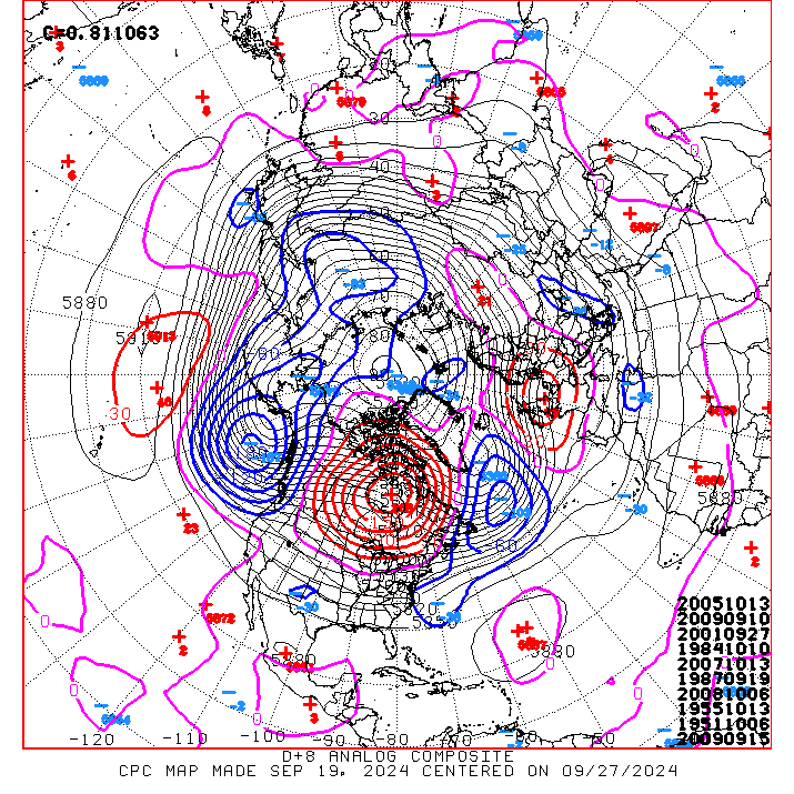
Interesting analog at the top of the list today....01/02/1985. This date had a decent winter storm move through the state at that time and fits what some of the models are showing for this weekend
0 likes
Lets go get take that 8-0 road record to Lambeau and bring back some cold after a WIN there shall we?
MOS guidance shows mid to upper teens later this week for DFW and low 20s for Austin.
MOS guidance shows mid to upper teens later this week for DFW and low 20s for Austin.
0 likes
The above post and any post by Ntxw is NOT an official forecast and should not be used as such. It is just the opinion of the poster and may or may not be backed by sound meteorological data. It is NOT endorsed by any professional institution including Storm2k. For official information, please refer to NWS products.
Help support Storm2K!
Help support Storm2K!
-
Texas Snowman

- Storm2k Moderator
- Posts: 6197
- Joined: Fri Jan 25, 2008 11:29 am
- Location: Denison, Texas
Bastardi just tweeted that GFS upgrade shows game time temp at Lambeau to be near zero.
Maue tweeted that the Euro (I believe that's what he referred to) indicates teens and an inch of snow.
Either way, it looks like Ice Bowl II is on.

Maue tweeted that the Euro (I believe that's what he referred to) indicates teens and an inch of snow.
Either way, it looks like Ice Bowl II is on.
0 likes
The above post and any post by Texas Snowman is NOT an official forecast and should not be used as such. It is just the opinion of the poster and may or may not be backed by sound meteorological data. It is NOT endorsed by any professional institution including storm2k.org. For official information, please refer to NWS products.
Re:
Texas Snowman wrote:Bastardi just tweeted that GFS upgrade shows game time temp at Lambeau to be near zero.
Maue tweeted that the Euro (I believe that's what he referred to) indicates teens and an inch of snow.
Either way, it looks like Ice Bowl II is on.
Yikes I just checked at another weather site and they are saying clear and cold!
0 likes
-
TheProfessor

- Professional-Met

- Posts: 3506
- Age: 29
- Joined: Tue Dec 03, 2013 10:56 am
- Location: Wichita, Kansas
The Weather in Green Bay could have a huge factor, Cold air and pass happy offenses don't work well with each other. The Cowboys Could have a huge advantage if it becomes cold and Windy.
0 likes
An alumnus of The Ohio State University.
Your local National Weather Service office is your best source for weather information.
Your local National Weather Service office is your best source for weather information.
-
Ralph's Weather
- S2K Supporter
- Posts: 3371
- Age: 38
- Joined: Fri Dec 13, 2013 11:55 am
- Location: Lindale, TX
- Contact:
Who is online
Users browsing this forum: No registered users and 123 guests