Texas Winter 2010-2011

Winter Weather Discussion

Moderator: S2k Moderators

Forum rules

The posts in this forum are NOT official forecast and should not be used as such. They are just the opinion of the poster and may or may not be backed by sound meteorological data. They are NOT endorsed by any professional institution or STORM2K.

Help Support Storm2K
Message
Author
User avatar
txagwxman
Professional-Met
Professional-Met
Posts: 960
Joined: Thu Dec 24, 2009 3:26 pm
Location: Tomball, TX

Re:

#2601 Postby txagwxman » Thu Jan 20, 2011 12:52 pm

DonWrk wrote:Very interesting video, thanks!

EDIT: I shouldn't have watched it. Now I'm going to be glued to mini ice age articles and not get anything done! I'm guessing magnetic reversal plays a big part in ice ages?

Junk science. I don't believe that sun spots have much of an impact at all. Net radiation loss/gain is roughly 1.3 watt/m^2. Maybe it has some effect on the upper-atmosphere and the QBO. However, not convinced.
0 likes   
“If you thought that science was certain - well, that is just an error on your part.”

gpsnowman
S2K Supporter
S2K Supporter
Posts: 3190
Joined: Fri Jan 07, 2011 10:35 am
Location: Grand Prairie Tx

#2602 Postby gpsnowman » Thu Jan 20, 2011 12:53 pm

Man, this is frustrating. Another storm just to our north. Oklahoma got hit pretty good. One of these bad boys is going to hit the Metroplex before it is all said and done. This cold day with wind sure does feel great though. Cant complain about that!
0 likes   

DonWrk
Category 1
Category 1
Posts: 488
Age: 37
Joined: Mon Jan 03, 2011 11:54 pm
Location: Collinsville, TX

Re: Re:

#2603 Postby DonWrk » Thu Jan 20, 2011 12:55 pm

Ntxw wrote:
We have plenty of cold to pay attention to the next few weeks alone nonetheless a mini ice age :wink: :wink:


Yeah, definitely don't need to get that conversation started up and just focus on things in there near futue lol
0 likes   

User avatar
txagwxman
Professional-Met
Professional-Met
Posts: 960
Joined: Thu Dec 24, 2009 3:26 pm
Location: Tomball, TX

#2604 Postby txagwxman » Thu Jan 20, 2011 12:58 pm

Just not much precip today in DFW. Probably GOOD, because DFW now 31F.
0 likes   
“If you thought that science was certain - well, that is just an error on your part.”

User avatar
DentonGal
Tropical Storm
Tropical Storm
Posts: 189
Joined: Sun Dec 27, 2009 6:25 am
Location: Denton, TX

Re:

#2605 Postby DentonGal » Thu Jan 20, 2011 12:59 pm

DonWrk wrote:Very interesting video, thanks!

EDIT: I shouldn't have watched it. Now I'm going to be glued to mini ice age articles and not get anything done! I'm guessing magnetic reversal plays a big part in ice ages?


LOL DonWrk! I know what you mean...it's all so very interesting! Solar minimums are a lot easier for me to understand than all this weather data....but I'm getting there!
0 likes   
Mom to 8 really is enough!

User avatar
txagwxman
Professional-Met
Professional-Met
Posts: 960
Joined: Thu Dec 24, 2009 3:26 pm
Location: Tomball, TX

Re: Texas Winter 2010-2011

#2606 Postby txagwxman » Thu Jan 20, 2011 1:12 pm

Euro no snow Monday.
0 likes   
“If you thought that science was certain - well, that is just an error on your part.”

User avatar
Ntxw
Storm2k Moderator
Storm2k Moderator
Posts: 22790
Joined: Wed Oct 21, 2009 6:34 pm
Location: DFW, Texas

Re: Texas Winter 2010-2011

#2607 Postby Ntxw » Thu Jan 20, 2011 1:19 pm

txagwxman wrote:Euro no snow Monday.


What about the following energy? Looks more like the GFS to me vs the Canadian which digs it into MX. QPF on the GFS isn't impressive but my guess is it will correct itself. I can't imagine such a non event with a potential cutoff.
0 likes   
The above post and any post by Ntxw is NOT an official forecast and should not be used as such. It is just the opinion of the poster and may or may not be backed by sound meteorological data. It is NOT endorsed by any professional institution including Storm2k. For official information, please refer to NWS products.

  Help support Storm2K!
Help Support Storm2K

User avatar
MississippiWx
S2K Supporter
S2K Supporter
Posts: 1699
Joined: Sat Aug 14, 2010 1:44 pm
Location: Hattiesburg, Mississippi

Re: Texas Winter 2010-2011

#2608 Postby MississippiWx » Thu Jan 20, 2011 1:43 pm

Noticed on the 12z GFS that it brings that cut-off low east into MS and LA, while showing an increase in QPF. Looks like a snow event here, but too bad it's still 6 days out. Hopefully it's a trend that will stick around. Gotta believe it will start showing more QPF back into TX as well.


Image
0 likes   
This post is not an official forecast and should not be used as such. It is just the opinion of MississippiWx and may or may not be backed by sound meteorological data. It is not endorsed by any professional institution including storm2k.org. For Official Information please refer to the NHC and NWS products.

User avatar
srainhoutx
S2K Supporter
S2K Supporter
Posts: 6919
Age: 67
Joined: Sun Jan 14, 2007 11:34 am
Location: Haywood County, NC
Contact:

Re: Texas Winter 2010-2011

#2609 Postby srainhoutx » Thu Jan 20, 2011 1:50 pm

Ntxw wrote:
txagwxman wrote:Euro no snow Monday.


What about the following energy? Looks more like the GFS to me vs the Canadian which digs it into MX. QPF on the GFS isn't impressive but my guess is it will correct itself. I can't imagine such a non event with a potential cutoff.


At hour 168, that feature is in S AZ/N MX. At hour 192, it's over the Baja :wink:
0 likes   
Carla/Alicia/Jerry(In The Eye)/Michelle/Charley/Ivan/Dennis/Katrina/Rita/Wilma/Ike/Harvey

Member: National Weather Association
Wx Infinity Forums
http://wxinfinity.com/index.php

Facebook.com/WeatherInfinity
Twitter @WeatherInfinity

User avatar
Ntxw
Storm2k Moderator
Storm2k Moderator
Posts: 22790
Joined: Wed Oct 21, 2009 6:34 pm
Location: DFW, Texas

Re: Texas Winter 2010-2011

#2610 Postby Ntxw » Thu Jan 20, 2011 1:58 pm

srainhoutx wrote:
Ntxw wrote:
txagwxman wrote:Euro no snow Monday.


What about the following energy? Looks more like the GFS to me vs the Canadian which digs it into MX. QPF on the GFS isn't impressive but my guess is it will correct itself. I can't imagine such a non event with a potential cutoff.


At hour 168, that feature is in S AZ/N MX. At hour 192, it's over the Baja :wink:


Yeah I see that. I was more pointing out the quirks of the GFS lacking moisture. It's a long way out to talk about details but a baja low is definitely optimistic! Euro also has a strong storm off Northern/Central California. First real big storm to penetrate the west coast ridge. Hmm...
0 likes   
The above post and any post by Ntxw is NOT an official forecast and should not be used as such. It is just the opinion of the poster and may or may not be backed by sound meteorological data. It is NOT endorsed by any professional institution including Storm2k. For official information, please refer to NWS products.


  Help support Storm2K!

Help Support Storm2K


downsouthman1
Category 2
Category 2
Posts: 663
Age: 45
Joined: Fri Jan 07, 2011 8:14 pm
Location: Rowlett, TX

Re: Texas Winter 2010-2011

#2611 Postby downsouthman1 » Thu Jan 20, 2011 2:01 pm

srainhoutx wrote:
Ntxw wrote:
txagwxman wrote:Euro no snow Monday.


What about the following energy? Looks more like the GFS to me vs the Canadian which digs it into MX. QPF on the GFS isn't impressive but my guess is it will correct itself. I can't imagine such a non event with a potential cutoff.


At hour 168, that feature is in S AZ/N MX. At hour 192, it's over the Baja :wink:


The 12Z GFS must be showing this move around beyond 126 hours, since I see it in West Texas by El Paso, Southern New Mexico, & adjacent Northern Mexico. It appears to be sitting in the base of the trough & it looks to me like it will be moving somewhat ELY/NELY from there, with it being fed moisture from the Gulf of Mexico by the 1028MB High that should be centered over Arkansas.

NOT AN OFFICIAL FORECAST!
0 likes   
Not a professional MET! My posts are merely speculation.

User avatar
jasons2k
Storm2k Executive
Storm2k Executive
Posts: 8245
Age: 51
Joined: Wed Jul 06, 2005 12:32 pm
Location: The Woodlands, TX

Re: Texas Winter 2010-2011

#2612 Postby jasons2k » Thu Jan 20, 2011 2:02 pm

I think some of my DFW friends have been too spoiled over the last few years with snow events. I lived many a year up there and saw nothing while OKC and Wichita Falls got pounded. It's just not normal for the DFW to get dumped-on every year, or multiple times each year, or have a foot of snow in one helping. More "normal" is an ice threat once or twice each year (if that) and a snow event every few years. If you got over 2 or 3 inches at once that would be considered a very rare snowstorm indeed. This streak of getting nailed each winter just won't last forever....
0 likes   

downsouthman1
Category 2
Category 2
Posts: 663
Age: 45
Joined: Fri Jan 07, 2011 8:14 pm
Location: Rowlett, TX

Re: Texas Winter 2010-2011

#2613 Postby downsouthman1 » Thu Jan 20, 2011 2:14 pm

jasons wrote:I think some of my DFW friends have been too spoiled over the last few years with snow events. I lived many a year up there and saw nothing while OKC and Wichita Falls got pounded. It's just not normal for the DFW to get dumped-on every year, or multiples times each year, or have a foot of snow in one helping. More "normal" is an ice threat once or twice each year (if that) and a snow event every few years. If you got over 2 or 3 inches at once that would be considered a very rare snowstorm indeed. This streak of getting nailed each winter just won't last forever....


Not to contradict you but if climate change has anything to do with it, I would say we will start to experience a new norm. But I know what you mean, when I lived up there, we would call a good snow 2-3 inches in 1 helping once/year.
0 likes   
Not a professional MET! My posts are merely speculation.

User avatar
Ntxw
Storm2k Moderator
Storm2k Moderator
Posts: 22790
Joined: Wed Oct 21, 2009 6:34 pm
Location: DFW, Texas

Re: Texas Winter 2010-2011

#2614 Postby Ntxw » Thu Jan 20, 2011 2:18 pm

jasons wrote:I think some of my DFW friends have been too spoiled over the last few years with snow events. I lived many a year up there and saw nothing while OKC and Wichita Falls got pounded. It's just not normal for the DFW to get dumped-on every year, or multiple times each year, or have a foot of snow in one helping. More "normal" is an ice threat once or twice each year (if that) and a snow event every few years. If you got over 2 or 3 inches at once that would be considered a very rare snowstorm indeed. This streak of getting nailed each winter just won't last forever....


I hear ya. But I'm not so sure exactly what 'normal' is anymore! There hasn't been a good ice storm in Texas the second half of the 2000s since the PDO went cold. We haven't been in such a regime since the 1950s-1970s. Wxman is suffering without his warm January and it looks like Feb isn't too optimistic :cry:. I don't think the Houston snow miracles the past few years were a mere coincidence. We may have to just go over what's 'normal' :lol:

Image
0 likes   
The above post and any post by Ntxw is NOT an official forecast and should not be used as such. It is just the opinion of the poster and may or may not be backed by sound meteorological data. It is NOT endorsed by any professional institution including Storm2k. For official information, please refer to NWS products.


  Help support Storm2K!

Help Support Storm2K


User avatar
srainhoutx
S2K Supporter
S2K Supporter
Posts: 6919
Age: 67
Joined: Sun Jan 14, 2007 11:34 am
Location: Haywood County, NC
Contact:

Re: Texas Winter 2010-2011

#2615 Postby srainhoutx » Thu Jan 20, 2011 2:26 pm

HPC giving some credence to the digging short wave idea next week...

12Z UPDATE... NEW GUIDANCE INCLUDING THE ECMWF HAS COME INTO
BETTER AGREEMENT WITH DAY 3 SUN PLAINS EVOLUTION WITH A BETTER
DEFINED SFC REFLECTION THAN THE 00Z ECMWF. THE FINAL FCST
INCORPORATES IDEAS FROM THE 12Z ECMWF/UKMET/CMC WITH THE GFS LESS
FAVORED AS IT IS ON THE DEEP SIDE OF THE SOLN SPREAD. UNCERTAINTY
REMAINS ABOUT AS HIGH AS BEFORE FOR THE REST OF THE FCST. THE
UKMET/CMC HAVE TRENDED TOWARD THE GFS SCENARIO OF PULLING A
SIGNIFICANT AMOUNT OF ENERGY SWWD INTO NWRN MEXICO BY DAY 5 TUE
THUS LEADING TO A MORE PROGRESSIVE/EWD WRN ATLC SYSTEM. HOWEVER
THE 12Z ECMWF MAINTAINS CONTINUITY... ALBEIT IN SLIGHTLY SLOWER
FORM... TOWARD A MORE CONSOLIDATED NRN STREAM MID LVL SYSTEM THAT
ULTIMATELY MAINTAINS AN EAST COAST SFC LOW ON THE WRN EDGE OF THE
GUIDANCE SPREAD. SOME TIMING/DETAIL DIFFS ARE NOTED WITH UPSTREAM
FEATURES WITH MORE DATA DESIRED BEFORE MAKING A CONFIDENT
ADJUSTMENT.
FOR DAYS 4-7 THE FULL EVALUATION OF LATEST SOLNS IN
LIGHT OF SENSITIVITY OF THE FCST PATTERN FAVORS ONLY MINOR DETAIL
ADJUSTMENTS TO THE UPDATED PRELIM ISSUANCE.


THE LARGE SCALE MEAN PATTERN SHOULD MAINTAIN WARM AND DRY CONDS
OVER MOST AREAS WEST OF THE ROCKIES AND BELOW NORMAL TEMPS OVER
THE ERN HALF OF THE LOWER 48
.
THE MOST EXTREME READINGS ARE FCST
OVER THE NORTHEAST ON SUN-MON WHEN HIGHS MAY BE UP TO 15-25 F
BELOW NORMAL. THERE IS STILL CONSIDERABLE UNCERTAINTY OVER THE
EVENTUAL NWD EXTENT OF WINTRY PCPN SPREADING EWD FROM THE PLAINS
SUN ONWARD... WITH POSSIBLE SCENARIOS OVER THE NORTHEAST BY
TUE-WED RANGING FROM A MAJOR EVENT TO NO PCPN AT ALL. CURRENT
FCST PREFERENCES ARE TOWARD HAVING AT LEAST SOME PCPN REACHING
NERN AREAS. MEANWHILE DEPENDING ON THE DEGREE OF GULF INFLOW
THERE MAY BE SOME LOCALLY MDT-HVY RNFL OVER EXTREME SRN AREAS.
BEHIND THIS SYSTEM SOME LOCATIONS FROM THE NRN ROCKIES INTO THE
GRTLKS/OH VALLEY MAY SEE ONE OR MORE DAYS OF LGT SNOW. THOUGH A
LOW PROBABILITY SOLN AT THIS TIME... POTENTIAL EXISTS FOR SOME
RESIDUAL SRN STREAM ENERGY TO GENERATE ANOTHER GULF OF MEXICO WAVE
LATE IN THE PERIOD.

RAUSCH
0 likes   
Carla/Alicia/Jerry(In The Eye)/Michelle/Charley/Ivan/Dennis/Katrina/Rita/Wilma/Ike/Harvey

Member: National Weather Association
Wx Infinity Forums
http://wxinfinity.com/index.php

Facebook.com/WeatherInfinity
Twitter @WeatherInfinity

User avatar
Portastorm
Storm2k Moderator
Storm2k Moderator
Posts: 9914
Age: 63
Joined: Fri Jul 11, 2003 9:16 am
Location: Round Rock, TX
Contact:

Re: Texas Winter 2010-2011

#2616 Postby Portastorm » Thu Jan 20, 2011 2:57 pm

Encouraging but will there be enough cold air to make something of it?!

Even with ULLs, you still have to have air temperatures close enough to freezing to optimize that full column cooling on top.
0 likes   

User avatar
Cuda17
S2K Supporter
S2K Supporter
Posts: 85
Age: 48
Joined: Mon Jan 03, 2011 5:03 pm
Location: Bellville, TX

Re: Texas Winter 2010-2011

#2617 Postby Cuda17 » Thu Jan 20, 2011 3:06 pm

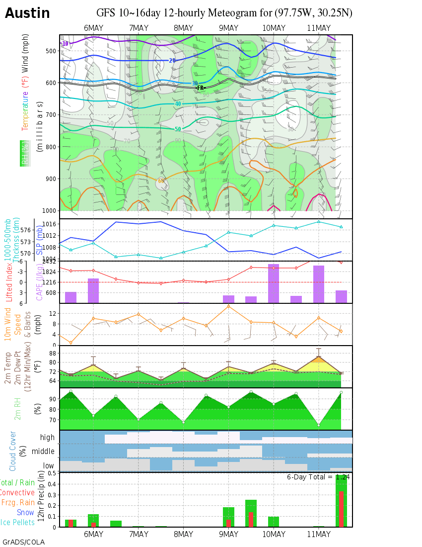
Looks good for Austin on the 3rd/4th. We'll see... :roll:

Image
0 likes   
Personal Forecast Disclaimer:
The posts in this forum are NOT official forecast and should not be used as such. They are just the opinion of the poster and may or may not be backed by sound meteorological data. They are NOT endorsed by any professional institution or storm2k.org. For official information, please refer to the NHC and NWS products.

User avatar
Cuda17
S2K Supporter
S2K Supporter
Posts: 85
Age: 48
Joined: Mon Jan 03, 2011 5:03 pm
Location: Bellville, TX

Re: Texas Winter 2010-2011

#2618 Postby Cuda17 » Thu Jan 20, 2011 3:14 pm

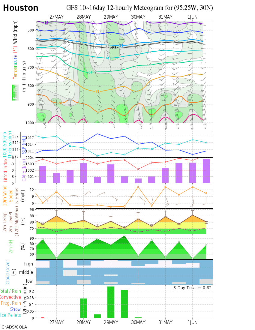
Hmmmm... even Houston is getting in on it for the 3rd/4th of Feb. Here's hoping...

Image
0 likes   
Personal Forecast Disclaimer:
The posts in this forum are NOT official forecast and should not be used as such. They are just the opinion of the poster and may or may not be backed by sound meteorological data. They are NOT endorsed by any professional institution or storm2k.org. For official information, please refer to the NHC and NWS products.

downsouthman1
Category 2
Category 2
Posts: 663
Age: 45
Joined: Fri Jan 07, 2011 8:14 pm
Location: Rowlett, TX

Re: Texas Winter 2010-2011

#2619 Postby downsouthman1 » Thu Jan 20, 2011 3:17 pm

Cuda17 wrote:Hmmmm... even Houston is getting in on it for the 3rd/4th of Feb. Here's hoping...

http://wxmaps.org/pix/iahgfsb.png


Do Killeen. Do Killeen please! As I'm the only representative in here from Killeen, it is pertinent to me. LOL
0 likes   
Not a professional MET! My posts are merely speculation.

User avatar
Cuda17
S2K Supporter
S2K Supporter
Posts: 85
Age: 48
Joined: Mon Jan 03, 2011 5:03 pm
Location: Bellville, TX

Re: Texas Winter 2010-2011

#2620 Postby Cuda17 » Thu Jan 20, 2011 3:23 pm

downsouthman1 wrote:
Cuda17 wrote:Hmmmm... even Houston is getting in on it for the 3rd/4th of Feb. Here's hoping...


Do Killeen. Do Killeen please! As I'm the only representative in here from Killeen, it is pertinent to me. LOL


Ha, ha... I don't have one for Killeen, Austin is the closest meteo to Killeen, from the sight that I get them from:

http://wxmaps.org/pix/meteograms.html
0 likes   
Personal Forecast Disclaimer:
The posts in this forum are NOT official forecast and should not be used as such. They are just the opinion of the poster and may or may not be backed by sound meteorological data. They are NOT endorsed by any professional institution or storm2k.org. For official information, please refer to the NHC and NWS products.


Return to “Winter Weather”

Who is online

Users browsing this forum: No registered users and 14 guests