

Moderator: S2k Moderators
 The posts in this forum are NOT official forecast and should not be used as such. They are just the opinion of the poster and may or may not be backed by sound meteorological data. They are NOT endorsed by any professional institution or STORM2K.


Cpv17 wrote:Quixotic wrote:The blocking up north is incredible
The 18z GEFS was crazy.
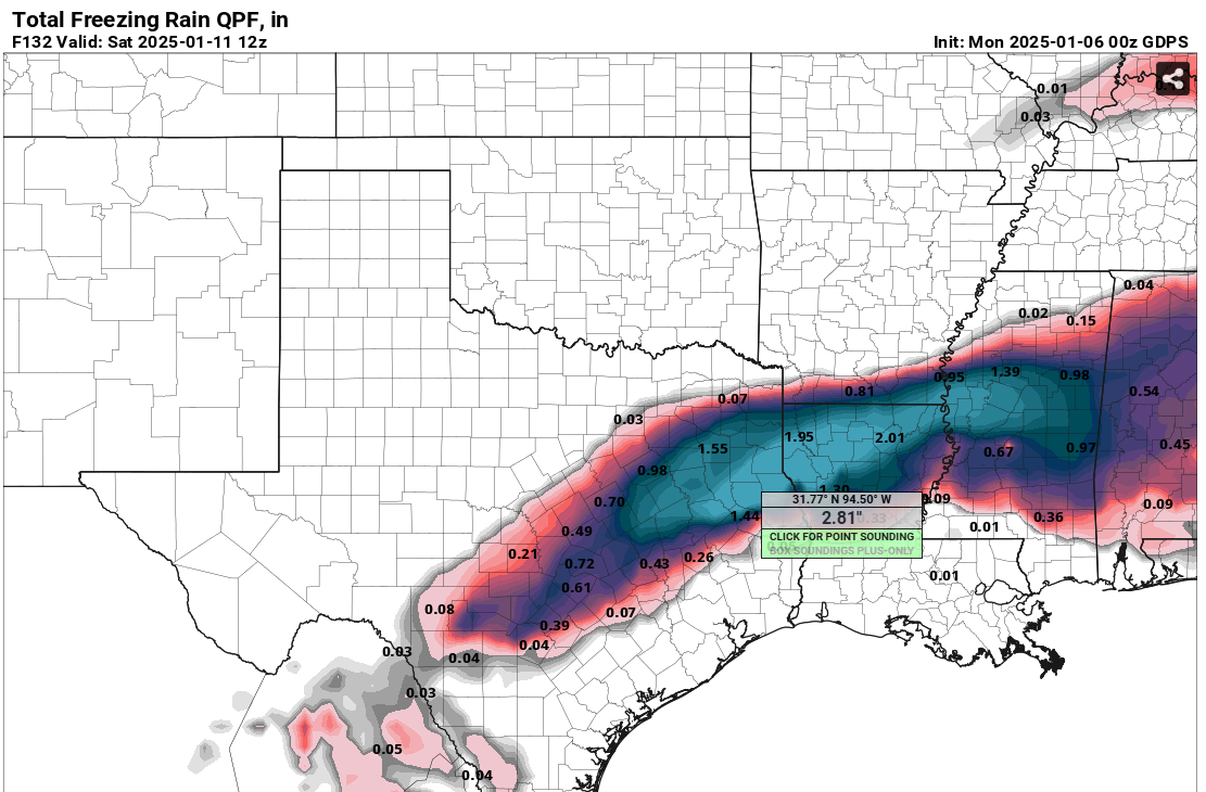
Stratton23 wrote:txtwister78 any chance if the short range guidance is correct, of aome of this frozen precipitation reaching se texas? , im about 45 miles west of houston in katy


bubba hotep wrote:The 00z GFS looks good above the surface, but in some areas of DFW, a lot of the snow falls with surface temps right at 32F.
HockeyTx82 wrote:Ntxw wrote:HockeyTx82 wrote:
Does that take away from anything we've discussed about these crazy numbers and consistency, or just adding more to share the wealth?
Share wealth, in fact if you have this thing slowing down even more and wraparound, it would snow longer.
Okay so folks have been on here since the beginning of this website, have we ever seen such numbers, model agreement and consistency at this time point within x amount of hours before the event unfolds and actually have it go the way it says or did it just completely bomb out and nothing happened?
I know we like to dream big but my gosh at this point it seems like this is getting to the ridiculousness aspect of the amount of snow potentially we could truly get and we're not crazy for posting these "Clown Maps"
bubba hotep wrote:The 00z GFS looks good above the surface, but in some areas of DFW, a lot of the snow falls with surface temps right at 32F.

bubba hotep wrote:The 00z GFS looks good above the surface, but in some areas of DFW, a lot of the snow falls with surface temps right at 32F.
Quixotic wrote:HockeyTx82 wrote:Ntxw wrote:
Share wealth, in fact if you have this thing slowing down even more and wraparound, it would snow longer.
Okay so folks have been on here since the beginning of this website, have we ever seen such numbers, model agreement and consistency at this time point within x amount of hours before the event unfolds and actually have it go the way it says or did it just completely bomb out and nothing happened?
I know we like to dream big but my gosh at this point it seems like this is getting to the ridiculousness aspect of the amount of snow potentially we could truly get and we're not crazy for posting these "Clown Maps"
Sure it happens both ways. Feb 2010 storm NWS still had 1-3” up when it started snowing and almost everybody got a foot because the ULL slowed way way down. Kinda like what NTX is saying about this one.
Had one in January 82 that was supposed to give us 6-8” and nothing. Not a flake. Sheared out.
Lately though I find the FWD crew to be pretty accurate of late, not that they have had many chances of late. Haha

orangeblood wrote:bubba hotep wrote:The 00z GFS looks good above the surface, but in some areas of DFW, a lot of the snow falls with surface temps right at 32F.
All models are trending colder, GFS has been a little slow to the party lately…not worried about DFW temps, looks like upper 20s for most of it
txtwister78 wrote:bubba hotep wrote:The 00z GFS looks good above the surface, but in some areas of DFW, a lot of the snow falls with surface temps right at 32F.
Yeah that's why I laugh a little when Bastardi goes full apocalypse with some of his social media hype predictions. High impact event no question for a day, "but 2-3 day shutdown"? Lol. I would expect surface temps to cool initially but then rise a degree or two and hold steady perhaps during most of that.
Gotwood wrote:txtwister78 wrote:bubba hotep wrote:The 00z GFS looks good above the surface, but in some areas of DFW, a lot of the snow falls with surface temps right at 32F.
Yeah that's why I laugh a little when Bastardi goes full apocalypse with some of his social media hype predictions. High impact event no question for a day, "but 2-3 day shutdown"? Lol. I would expect surface temps to cool initially but then rise a degree or two and hold steady perhaps during most of that.
You don’t think a foot of snow would shut down DFW for a couple days?

wxman22 wrote:0z Canadian
https://i.ibb.co/h8LHXGc/prateptype-imp-us-sc-8.png
https://i.ibb.co/30GdNdp/prateptype-imp-us-sc-9.png


Ntxw wrote:Quixotic wrote:HockeyTx82 wrote:
Okay so folks have been on here since the beginning of this website, have we ever seen such numbers, model agreement and consistency at this time point within x amount of hours before the event unfolds and actually have it go the way it says or did it just completely bomb out and nothing happened?
I know we like to dream big but my gosh at this point it seems like this is getting to the ridiculousness aspect of the amount of snow potentially we could truly get and we're not crazy for posting these "Clown Maps"
Sure it happens both ways. Feb 2010 storm NWS still had 1-3” up when it started snowing and almost everybody got a foot because the ULL slowed way way down. Kinda like what NTX is saying about this one.
Had one in January 82 that was supposed to give us 6-8” and nothing. Not a flake. Sheared out.
Lately though I find the FWD crew to be pretty accurate of late, not that they have had many chances of late. Haha
I remember that storm very vividly. Had checked WPC (might have been called HPC at the time) and had a circle right around the DFW region for 10% of 12" or greater. Brushed it off completely. One of the mets who doesn't post anymore noted how strong the STJ was coming out of the East Pacific. That was the telling sign. The guidance had said we would be too warm right before it started but for some snow as the coastal low would take the qpf. But the phase ejected the jet northeastward. Our friend orangeblood was constantly posting the RAP and how convection kept back building out of the west-southwest and it continued the rest is history.
Gotwood wrote:txtwister78 wrote:bubba hotep wrote:The 00z GFS looks good above the surface, but in some areas of DFW, a lot of the snow falls with surface temps right at 32F.
Yeah that's why I laugh a little when Bastardi goes full apocalypse with some of his social media hype predictions. High impact event no question for a day, "but 2-3 day shutdown"? Lol. I would expect surface temps to cool initially but then rise a degree or two and hold steady perhaps during most of that.
You don’t think a foot of snow would shut down DFW for a couple days?
TeamPlayersBlue wrote:Ntxw wrote:Quixotic wrote:
Sure it happens both ways. Feb 2010 storm NWS still had 1-3” up when it started snowing and almost everybody got a foot because the ULL slowed way way down. Kinda like what NTX is saying about this one.
Had one in January 82 that was supposed to give us 6-8” and nothing. Not a flake. Sheared out.
Lately though I find the FWD crew to be pretty accurate of late, not that they have had many chances of late. Haha
I remember that storm very vividly. Had checked WPC (might have been called HPC at the time) and had a circle right around the DFW region for 10% of 12" or greater. Brushed it off completely. One of the mets who doesn't post anymore noted how strong the STJ was coming out of the East Pacific. That was the telling sign. The guidance had said we would be too warm right before it started but for some snow as the coastal low would take the qpf. But the phase ejected the jet northeastward. Our friend orangeblood was constantly posting the RAP and how convection kept back building out of the west-southwest and it continued the rest is history.
I drove right into Plano during the early 1/3rd of that storm. Was wild. Moisture just kept streaming in and in all night. City was like walking around at a ski resort for the rest of the weekend.
Very very good sign that the ULL is phasing earlier. Exactly what you want. DFW is going to get buried by this thing. Also, it's very possible to think that the GFS is on the lower side of snow falling. If its saying 12", its possible some spots get close to 20".
Users browsing this forum: Stratton23, Tireman4 and 102 guests


