Texas Winter 2012-2013

Winter Weather Discussion

Moderator: S2k Moderators

Forum rules

The posts in this forum are NOT official forecast and should not be used as such. They are just the opinion of the poster and may or may not be backed by sound meteorological data. They are NOT endorsed by any professional institution or STORM2K.

Help Support Storm2K
Message
Author
aggiecutter
Category 5
Category 5
Posts: 1753
Joined: Thu Oct 14, 2004 9:22 pm
Location: Texarkana

Re: Texas Winter 2012-2013

#3121 Postby aggiecutter » Tue Jan 15, 2013 5:58 pm

Portastorm wrote::uarrow:

You guys need to re-read what the NWS forecaster wrote in that AFD. He explains quite well why the synoptics tonight are different than last night and why a winter "surprise" is a lot less likely.

Sorry. You got your snow and sleet today already! Alright ... whose next in line? Austin? San Antonio? Houston? :cheesy:

The forecasters out of the Shreveport NWS office are predicting a 60% chance of snow for Texarkana tonight. The 18z NAM has introduced moisture back into the Texarkana region tonight. The NAM was the only model that handled the last system correctly. I'm getting tired of these consecutive winter weather events. This will be the third day in a row of sleet or snow. I guess I should move to Austin where winter weather rarely occurs.
http://forecast.weather.gov/MapClick.ph ... 9&site=shv
0 likes   

User avatar
TexasF6
S2K Supporter
S2K Supporter
Posts: 816
Joined: Mon Aug 09, 2004 9:33 pm
Location: Austin, TX

Re: Re:

#3122 Postby TexasF6 » Tue Jan 15, 2013 6:09 pm

Tireman4 wrote:
Texas Snowman wrote:Portastorm isn't as much fun now as he was in the old days! :D


He will come back. The force that is Wxman57 can only linger so long. It will fade my friend. In time, snow will be his only purpose (and the PWC) again. Their motto, "You want snow, you got it" will ring through every meteorological office again.


"FEAR of no snow is the path to the WARM side of the Force!!! I sense much fear in this forum, much fear...We must unlearn, what we have learned from Wxman57; corrupt you it will..."

-Jedi Snowmaster Yoda

:D
0 likes   

Brent
S2K Supporter
S2K Supporter
Posts: 38095
Age: 37
Joined: Sun May 16, 2004 10:30 pm
Location: Tulsa Oklahoma
Contact:

Re: Texas Winter 2012-2013

#3123 Postby Brent » Tue Jan 15, 2013 6:12 pm

aggiecutter wrote:
Portastorm wrote::uarrow:

You guys need to re-read what the NWS forecaster wrote in that AFD. He explains quite well why the synoptics tonight are different than last night and why a winter "surprise" is a lot less likely.

Sorry. You got your snow and sleet today already! Alright ... whose next in line? Austin? San Antonio? Houston? :cheesy:

The forecasters out of the Shreveport NWS office are predicting a 60% chance of snow for Texarkana tonight. The 18z NAM has introduced moisture back into the Texarkana region tonight. The NAM was the only model that handled the last system correctly. I'm getting tired of these consecutive winter weather events. This will be the third day in a row of sleet or snow. I guess I should move to Austin where winter weather rarely occurs.
http://forecast.weather.gov/MapClick.ph ... 9&site=shv


I'll be glad to take some of this snow off your hands. :P Have watched Dallas get snow 3-4 times and I've yet to have a thing...
0 likes   
#neversummer

orangeblood
S2K Supporter
S2K Supporter
Posts: 3714
Joined: Tue Dec 15, 2009 6:14 pm
Location: Fort Worth, TX

Re:

#3124 Postby orangeblood » Tue Jan 15, 2013 6:16 pm

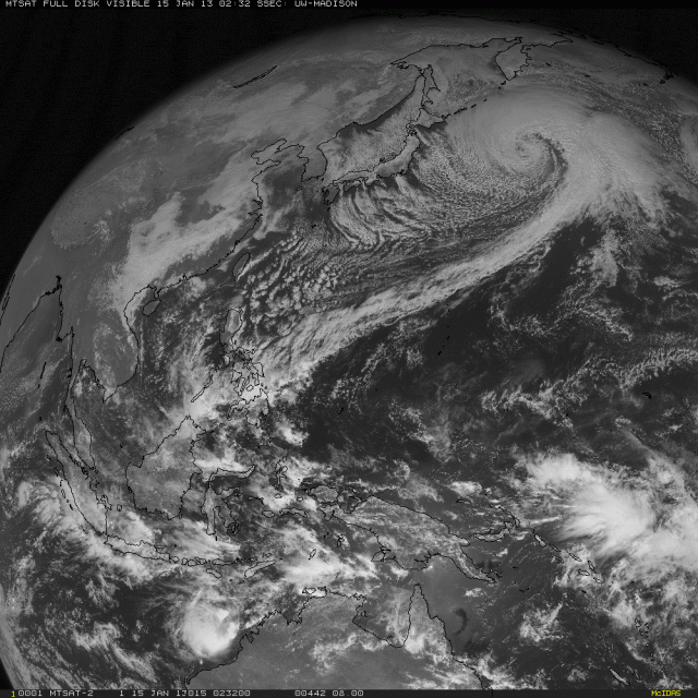
Ntxw wrote:Looking ahead again (you knew it was coming :cheesy:) Jan 28th-Feb 2nd ish, look for a potential major system. It should be associated with Arctic front number 2. Could be a phaser with a baja low and incoming low from Alaska and building heights behind it. Keep that in the back of our minds.


Well that would fit the time frame when this monster extratropical cyclone in the North Pacific would arrive on the west coast....this storm according to the GFS will bomb out and deepen to around 932 mb over the next 24 hours. This would make it one of the most rapidly developing storms of all time if it were to verify. Now models still aren't sure where this storm will end up but some have it arriving on the west coast in about 10 days. Something to follow over the next 7-10 days to fit your forecast Ntxw....

Image
0 likes   

User avatar
TeamPlayersBlue
Category 5
Category 5
Posts: 3445
Joined: Tue Feb 02, 2010 1:44 am
Location: Denver/Applewood, CO

#3125 Postby TeamPlayersBlue » Tue Jan 15, 2013 6:47 pm

I noticed RyanMaues tweets about that storm, would that buckle the jet stream like strong Typhoons do ? That storm is extremely impressive. Def want to keep tabs on that storm and see how it progresses across the Pacific
0 likes   
Personal Forecast Disclaimer:
The posts in this forum are NOT official forecast and should not be used as such. They are just the opinion of the poster and may or may not be backed by sound meteorological data. They are NOT endorsed by any professional institution or storm2k.org. For official information, please refer to the NHC and NWS products.

User avatar
Ntxw
Storm2k Moderator
Storm2k Moderator
Posts: 22788
Joined: Wed Oct 21, 2009 6:34 pm
Location: DFW, Texas

Re: Re:

#3126 Postby Ntxw » Tue Jan 15, 2013 6:48 pm

orangeblood wrote:Well that would fit the time frame when this monster extratropical cyclone in the North Pacific would arrive on the west coast....this storm according to the GFS will bomb out and deepen to around 932 mb over the next 24 hours.


I did notice that! It's like the far east version of a nor'easter on steroids! I wasn't using the system as part of the thoughts but it's good that you noticed the connection before me :lol:. I wonder if the same drivers are at work like during the fall when a cyclone re-curves in the WPAC translates to cold 7-10 days down the line in NA.

Edit: Looks like TPB got there first to the idea
0 likes   
The above post and any post by Ntxw is NOT an official forecast and should not be used as such. It is just the opinion of the poster and may or may not be backed by sound meteorological data. It is NOT endorsed by any professional institution including Storm2k. For official information, please refer to NWS products.

  Help support Storm2K!
Help Support Storm2K

User avatar
TexasF6
S2K Supporter
S2K Supporter
Posts: 816
Joined: Mon Aug 09, 2004 9:33 pm
Location: Austin, TX

Re: Texas Winter 2012-2013

#3127 Postby TexasF6 » Tue Jan 15, 2013 7:52 pm

I know this is not supposed to happen? But I see sleet & snow returns on the radar outside of Dallas? Anyone able to confirm this?
0 likes   

User avatar
Ntxw
Storm2k Moderator
Storm2k Moderator
Posts: 22788
Joined: Wed Oct 21, 2009 6:34 pm
Location: DFW, Texas

Re: Texas Winter 2012-2013

#3128 Postby Ntxw » Tue Jan 15, 2013 8:09 pm

TexasF6 wrote:I know this is not supposed to happen? But I see sleet & snow returns on the radar outside of Dallas? Anyone able to confirm this?


None of the sites underneath report anything, maybe it's virga. We'll know when/if it gets into the metroplex since we have a lot of posters to keep an eye
0 likes   
The above post and any post by Ntxw is NOT an official forecast and should not be used as such. It is just the opinion of the poster and may or may not be backed by sound meteorological data. It is NOT endorsed by any professional institution including Storm2k. For official information, please refer to NWS products.


  Help support Storm2K!

Help Support Storm2K


User avatar
GaryHughes
S2K Supporter
S2K Supporter
Posts: 88
Joined: Tue Dec 18, 2012 12:39 am
Location: Parker County, near Springtown

Re: Texas Winter 2012-2013

#3129 Postby GaryHughes » Tue Jan 15, 2013 8:12 pm

TexasF6 wrote:I know this is not supposed to happen? But I see sleet & snow returns on the radar outside of Dallas? Anyone able to confirm this?


Been watching this myself... I'm in North Parker County, I will let you know shortly as it's approaching my location soon.

Edit : nothing fell at my location.
Last edited by GaryHughes on Tue Jan 15, 2013 8:57 pm, edited 1 time in total.
0 likes   
The above post and any post by GaryHughes is NOT an official forecast and should not be used as such. It is just the opinion of the poster and may or may not be backed by sound meteorological data. It is NOT endorsed by any professional institution including storm2k.org. For official information, please refer to NWS products.

User avatar
dhweather
S2K Supporter
S2K Supporter
Posts: 6199
Joined: Sat Aug 14, 2004 9:29 pm
Location: Heath, TX
Contact:

Re: Re:

#3130 Postby dhweather » Tue Jan 15, 2013 8:14 pm

orangeblood wrote:
Ntxw wrote:Looking ahead again (you knew it was coming :cheesy:) Jan 28th-Feb 2nd ish, look for a potential major system. It should be associated with Arctic front number 2. Could be a phaser with a baja low and incoming low from Alaska and building heights behind it. Keep that in the back of our minds.


Well that would fit the time frame when this monster extratropical cyclone in the North Pacific would arrive on the west coast....this storm according to the GFS will bomb out and deepen to around 932 mb over the next 24 hours. This would make it one of the most rapidly developing storms of all time if it were to verify. Now models still aren't sure where this storm will end up but some have it arriving on the west coast in about 10 days. Something to follow over the next 7-10 days to fit your forecast Ntxw....


Man, that already looks impressive! 932 this time of year on a cold core is impressive, of course, if it happens.
0 likes   

User avatar
dhweather
S2K Supporter
S2K Supporter
Posts: 6199
Joined: Sat Aug 14, 2004 9:29 pm
Location: Heath, TX
Contact:

#3131 Postby dhweather » Tue Jan 15, 2013 8:16 pm

Precip? Impossible! It's positively tilted, so it positively won't produce any precip. :lol:
0 likes   

User avatar
Ntxw
Storm2k Moderator
Storm2k Moderator
Posts: 22788
Joined: Wed Oct 21, 2009 6:34 pm
Location: DFW, Texas

Re: Re:

#3132 Postby Ntxw » Tue Jan 15, 2013 8:21 pm

dhweather wrote:Man, that already looks impressive! 932 this time of year on a cold core is impressive, of course, if it happens.


Here is NOAA's current analysis of it. It's currently 937mb! Spectacle!

Image
0 likes   
The above post and any post by Ntxw is NOT an official forecast and should not be used as such. It is just the opinion of the poster and may or may not be backed by sound meteorological data. It is NOT endorsed by any professional institution including Storm2k. For official information, please refer to NWS products.


  Help support Storm2K!

Help Support Storm2K


User avatar
horselattitudesfarm
Category 1
Category 1
Posts: 315
Joined: Thu Jul 16, 2009 5:55 pm
Location: Asheville, NC (formerly from Dallas, TX)

Re: Re:

#3133 Postby horselattitudesfarm » Tue Jan 15, 2013 8:28 pm

orangeblood wrote:
Ntxw wrote:Looking ahead again (you knew it was coming :cheesy:) Jan 28th-Feb 2nd ish, look for a potential major system. It should be associated with Arctic front number 2. Could be a phaser with a baja low and incoming low from Alaska and building heights behind it. Keep that in the back of our minds.


Well that would fit the time frame when this monster extratropical cyclone in the North Pacific would arrive on the west coast....this storm according to the GFS will bomb out and deepen to around 932 mb over the next 24 hours. This would make it one of the most rapidly developing storms of all time if it were to verify. Now models still aren't sure where this storm will end up but some have it arriving on the west coast in about 10 days. Something to follow over the next 7-10 days to fit your forecast Ntxw....


Must be all that Fukashima radiation!
0 likes   

User avatar
vbhoutex
Storm2k Executive
Storm2k Executive
Posts: 29113
Age: 73
Joined: Wed Oct 09, 2002 11:31 pm
Location: Cypress, TX
Contact:

Re:

#3134 Postby vbhoutex » Tue Jan 15, 2013 8:42 pm

TeamPlayersBlue wrote:I'm in the surprise bandwagon for tonight.

Heavy amount of moisture is now coming up from Mexico with the STJ. Should see some precip in SE TX from this within the next few hours.

I'm seeing enough to give me hope of a surprise. First hint was seeing the clouds over Houston as I came home tonight. They are obviously thickening up with more moisture. If that moisture out of S TX makes it here at the right time I think we could get the surprise, especially if the cold core tracks further South. Amatuer? Yes? -removed-? Don't tell anyone or I will get in trouble. Possible? We shall see.
0 likes   
Skywarn, C.E.R.T.
Please click below to donate to STORM2K to help with the expenses of keeping the site going:
Image

User avatar
TeamPlayersBlue
Category 5
Category 5
Posts: 3445
Joined: Tue Feb 02, 2010 1:44 am
Location: Denver/Applewood, CO

#3135 Postby TeamPlayersBlue » Tue Jan 15, 2013 9:10 pm

Like you said, we shall see. Temp is 35.2F and falling. Humidity has fallen a bit to 89% as well.
0 likes   
Personal Forecast Disclaimer:
The posts in this forum are NOT official forecast and should not be used as such. They are just the opinion of the poster and may or may not be backed by sound meteorological data. They are NOT endorsed by any professional institution or storm2k.org. For official information, please refer to the NHC and NWS products.

pwrdog
Tropical Storm
Tropical Storm
Posts: 193
Joined: Fri Jan 26, 2007 5:58 am
Location: Texas

#3136 Postby pwrdog » Tue Jan 15, 2013 9:16 pm

Echos picking up near Corpus... Moving NNE... Maybe the start???
0 likes   

User avatar
TexasSam
Category 2
Category 2
Posts: 573
Age: 66
Joined: Thu Aug 28, 2003 12:16 am
Location: Port Arthur, Texas

Re: Texas Winter 2012-2013

#3137 Postby TexasSam » Tue Jan 15, 2013 9:20 pm

It's been "misting" here in Baytown for about a hour.
0 likes   

JackCruz
Tropical Wave
Tropical Wave
Posts: 5
Joined: Thu Sep 20, 2012 4:17 pm
Location: Houston/Cypress,tx

Re: Texas Winter 2012-2013

#3138 Postby JackCruz » Tue Jan 15, 2013 9:22 pm

Hey second time posting on this forum. I live in the Cypress area..and I'm praying for at least a snow flake or two around here. :cold: what radars are you guys looking at?
0 likes   

User avatar
TexasSam
Category 2
Category 2
Posts: 573
Age: 66
Joined: Thu Aug 28, 2003 12:16 am
Location: Port Arthur, Texas

Re: Texas Winter 2012-2013

#3139 Postby TexasSam » Tue Jan 15, 2013 9:24 pm

The only working radar in Houston that I know of is Ch. 13's The weather service is down for upgrade.
http://abclocal.go.com/ktrk/doppler?section=weather/doppler&id=5750607
0 likes   

User avatar
TeamPlayersBlue
Category 5
Category 5
Posts: 3445
Joined: Tue Feb 02, 2010 1:44 am
Location: Denver/Applewood, CO

#3140 Postby TeamPlayersBlue » Tue Jan 15, 2013 9:43 pm

http://www.meteo.psu.edu/~fxg1/NARR/2004/us1225.php

Here is the 2004 storms upper air charts as it was developing. Check out the similarities and differences to this low pressure. The main difference seems to be the moisture at the 700 MB level. Well, according to the water vapor imagery, there is plenty of moisture. Im not sure at what level the moisture is at, but there is tons of it. I think we are still a few hours away from anything happening IF something were to even happen. Maybe not till 3AM etc.
0 likes   
Personal Forecast Disclaimer:
The posts in this forum are NOT official forecast and should not be used as such. They are just the opinion of the poster and may or may not be backed by sound meteorological data. They are NOT endorsed by any professional institution or storm2k.org. For official information, please refer to the NHC and NWS products.


Return to “Winter Weather”

Who is online

Users browsing this forum: No registered users and 16 guests