Texas Winter 2025-2026
Moderator: S2k Moderators
Forum rules
 The posts in this forum are NOT official forecast and should not be used as such. They are just the opinion of the poster and may or may not be backed by sound meteorological data. They are NOT endorsed by any professional institution or STORM2K.
 The posts in this forum are NOT official forecast and should not be used as such. They are just the opinion of the poster and may or may not be backed by sound meteorological data. They are NOT endorsed by any professional institution or STORM2K.
-
orangeblood
- S2K Supporter

- Posts: 3895
- Joined: Tue Dec 15, 2009 6:14 pm
- Location: Fort Worth, TX
Re: Texas Winter 2025-2026
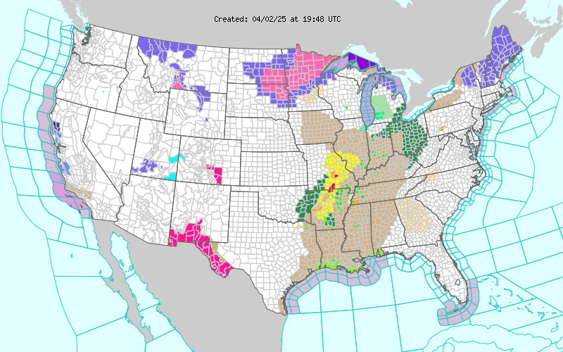
This is map is going to continue getting brighter!!! Very rare sight to see


8 likes
- CaptinCrunch
- S2K Supporter

- Posts: 8777
- Age: 58
- Joined: Mon Nov 03, 2003 4:33 pm
- Location: Kennedale, TX (Tarrant Co.)
Re: Texas Winter 2025-2026
Portastorm wrote:I can tell you that this storm is being taken seriously by Texas state government. Our state emergency management council is elevating its activation status to provide cross-agency resources and personnel to assist as needed.
I got called into a meeting this morning at 8am to go over out EMS text msgs system to ensure it was up to date with staff information. Good times
1 likes
-
rwfromkansas
- Category 5

- Posts: 3028
- Joined: Sat Aug 27, 2005 12:47 am
- Location: North Fort Worth
Re: Texas Winter 2025-2026
Got a notice that FWD extended the watch until Sunday noon. If we could get some decent heavy snow overnight even for a little bit Saturday night that would be great since the darkness would help accumulations and bring in cooler temps.
Last edited by rwfromkansas on Wed Jan 21, 2026 2:43 pm, edited 1 time in total.
4 likes
Re: Texas Winter 2025-2026
Stratton23 wrote:Interesting to see the EPS has a bit of a decent snowfall signal around the 30th, especially for parts much further south
Yep. I've been watching this closely for south Louisiana
1 likes
- Portastorm
- Storm2k Moderator

- Posts: 9954
- Age: 63
- Joined: Fri Jul 11, 2003 9:16 am
- Location: Round Rock, TX
- Contact:
Re: Texas Winter 2025-2026
CaptinCrunch wrote:Portastorm wrote:I can tell you that this storm is being taken seriously by Texas state government. Our state emergency management council is elevating its activation status to provide cross-agency resources and personnel to assist as needed.
I got called into a meeting this morning at 8am to go over out EMS text msgs system to ensure it was up to date with staff information. Good times
Right there with you! I’m officially “on call” for this weekend.
1 likes
Any forecasts under my name are to be taken with a grain of salt. Get your best forecasts from the National Weather Service and National Hurricane Center.
-
jaguars_22
- Category 2

- Posts: 629
- Joined: Tue Jun 20, 2017 2:26 pm
- Location: Victoria TX
Re: Texas Winter 2025-2026
What’s to stop this thing from digging even more and coming out of Mexico into the del rio area? Would that have more cold associated with it for San Antonio area points east?
0 likes
Re: Texas Winter 2025-2026
rwfromkansas wrote:Got a notice that FWD extended the watch until Sunday noon. If we could get some decent heavy snow overnight even for a little bit Saturday night that would be great since the darkness would help accumulations and bring in cooler temps.
Temp gradient Saturday afternoon, even could get wild. Something like single digits in Abilene, teens at DFW, and 20s in Corsicana.
4 likes
The above post and any post by Ntxw is NOT an official forecast and should not be used as such. It is just the opinion of the poster and may or may not be backed by sound meteorological data. It is NOT endorsed by any professional institution including Storm2k. For official information, please refer to NWS products.
- cajungal
- Category 5

- Posts: 2354
- Age: 49
- Joined: Sun Mar 14, 2004 9:34 pm
- Location: Schriever, Louisiana (60 miles southwest of New Orleans)
Re: Texas Winter 2025-2026
Harp.1 wrote:Stratton23 wrote:Interesting to see the EPS has a bit of a decent snowfall signal around the 30th, especially for parts much further south
Yep. I've been watching this closely for south Louisiana
Just hope this time it goes all the way to the coast instead of going north of us and we just get a cold rain.
1 likes
- wxman57
- Moderator-Pro Met

- Posts: 23172
- Age: 68
- Joined: Sat Jun 21, 2003 8:06 pm
- Location: Houston, TX (southwest)
Re: Texas Winter 2025-2026
Portastorm wrote:CaptinCrunch wrote:Portastorm wrote:I can tell you that this storm is being taken seriously by Texas state government. Our state emergency management council is elevating its activation status to provide cross-agency resources and personnel to assist as needed.
I got called into a meeting this morning at 8am to go over out EMS text msgs system to ensure it was up to date with staff information. Good times
Right there with you! I’m officially “on call” for this weekend.
I'm not only "on call", I'm "on" for the weekend. I've had only 2 days off since Dec. 29th. Was working a long duration project until last Friday and now I'm in winter weather mode coverage. I'll have more comp days this January than I had all last hurricane season.
I'm not worried at all about power outages, though, as my new whole-house generator is ready and waiting. I think we'll just see a glazing of bridges and overpasses here in Houston. North parts of the county could have enough freezing rain to cause some power issues.
4 likes
- wxman57
- Moderator-Pro Met

- Posts: 23172
- Age: 68
- Joined: Sat Jun 21, 2003 8:06 pm
- Location: Houston, TX (southwest)
Re: Texas Winter 2025-2026
cajungal wrote:Harp.1 wrote:Stratton23 wrote:Interesting to see the EPS has a bit of a decent snowfall signal around the 30th, especially for parts much further south
Yep. I've been watching this closely for south Louisiana
Just hope this time it goes all the way to the coast instead of going north of us and we just get a cold rain.
Looking like cold rain and maybe some light freezing rain and sleet as the precipitation ends on Sunday. This day last year we had that big snow storm. Not this time for the coastal areas.
1 likes
- CaptinCrunch
- S2K Supporter

- Posts: 8777
- Age: 58
- Joined: Mon Nov 03, 2003 4:33 pm
- Location: Kennedale, TX (Tarrant Co.)
Re: Texas Winter 2025-2026
orangeblood wrote:This is map is going to continue getting brighter!!! Very rare sight to see
https://www.weather.gov/wwamap/png/US.png
Most of TX will be upgraded to a WSW through Sunday afternoon sometime early Friday if not Thursday night. Need those late Thursday model runs first though.
1 likes
-
UTSARoadrunner4
- Category 1

- Posts: 265
- Age: 29
- Joined: Wed Aug 26, 2020 11:19 pm
Re: Texas Winter 2025-2026
wxman22 wrote:Winter Storm Watch issued for portions of South Central Texas.
https://i.ibb.co/RTsJZkB0/IMG-0611.pngIncluding the cities of Austin, La Grange, Del Rio, Llano,
Leakey, San Marcos, Giddings, Kerrville, Fredericksburg,
Lockhart, Bastrop, Burnet, Georgetown, New Braunfels, Blanco,
Bandera, Rocksprings, and Boerne
1221 PM CST Wed Jan 21 2026
...WINTER STORM WATCH IN EFFECT FROM LATE FRIDAY NIGHT THROUGH
SUNDAY MORNING...
* WHAT...Light to moderate accumulations of mainly ice and sleet are
likely across the region late Friday night through Sunday morning.
In addition, dangerously cold temperatures are expected Saturday
night through Monday morning.
* WHERE...Northern portions of south central Texas.
* WHEN...From late Friday night through Sunday morning.
* IMPACTS...Roads, especially bridges and overpasses, will likely
become slick and hazardous. Ice accumulation on power lines and
tree limbs may cause power outages. Extreme cold will become life
threatening and likely damage unprotected pipes and put livestock
at risk.
* ADDITIONAL DETAILS...Areas across the Hill Country could see
wintry precipitation effects as early as Midnight Saturday. Areas
along the I-35 Corridor should expect wintry precipitation as
early as daybreak Saturday. Areas south and east of I-35 should
experience wintry precipitation in the daytime hours Saturday.
PRECAUTIONARY/PREPAREDNESS ACTIONS...
Monitor the latest forecasts for updates on this situation.
Persons should consider delaying all travel. If travel is absolutely
necessary, drive with extreme caution. Consider taking a winter
storm kit along with you, including such items as tire chains,
booster cables, flashlight, shovel, blankets and extra clothing.
Also take water, a first aid kit, and anything else that would help
you survive in case you become stranded.
San Antonio left out (for now). Hopefully it’s stays that way. Sometimes it’s good to not let Rudolph play in any reindeer games.
0 likes
Re: Texas Winter 2025-2026
jaguars_22 wrote:What’s to stop this thing from digging even more and coming out of Mexico into the del rio area? Would that have more cold associated with it for San Antonio area points east?
I was gonna ask that same question
0 likes
-
Brazoria979cnty
- Tropical Low

- Posts: 14
- Joined: Sat Jan 17, 2026 5:45 pm
- Contact:
Re: Texas Winter 2025-2026
wxman57 wrote:cajungal wrote:Harp.1 wrote:Yep. I've been watching this closely for south Louisiana
Just hope this time it goes all the way to the coast instead of going north of us and we just get a cold rain.
Looking like cold rain and maybe some light freezing rain and sleet as the precipitation ends on Sunday. This day last year we had that big snow storm. Not this time for the coastal areas.
you think brazoria cnty will be added to the watch area maybe tomorrow or friday?
0 likes
Re: Texas Winter 2025-2026
Here's a betting challenge for the EC surface temps, it has 50s for most of the region (except the Red River valley 40s) next Tuesday afternoon. Book it.
3 likes
The above post and any post by Ntxw is NOT an official forecast and should not be used as such. It is just the opinion of the poster and may or may not be backed by sound meteorological data. It is NOT endorsed by any professional institution including Storm2k. For official information, please refer to NWS products.
-
Ralph's Weather
- S2K Supporter

- Posts: 3371
- Age: 38
- Joined: Fri Dec 13, 2013 11:55 am
- Location: Lindale, TX
- Contact:
Re: Texas Winter 2025-2026
bbowman7 wrote:Trying to keep up with all of this on the thread, but I am one of those guys who just loves weather, but I do not understand the terminology and the details! So, I need help I guess!
Can someone tell me, based on the latest information, what the Tyler/Longview (Henderson in particular) area looks like? This is school related, so trying to get a better idea for our after school activities, bus routes, etc..for Friday afternoon and on Monday. Looking for possible timing of when it hits this area, how much will hit us and what it will be (rain, freezing rain, snow, etc..)
Thanks in advance.
Our are a is looking like rain until late Friday, at this time I expect school traffic Friday to be ice free. Then Fz rain Fri night, sleet Sat, mixing with snow late Sat and snow on Sunday. temps will be cold enough for road impacts starting likely after midnight Fri night. Temps are looking to be very cold (teens to maybe low 20s) so impacts will be sustained into Monday. Monday may stay in 20s but sunshine should help begin improvements. Lows early next week look to be in single digits so anything that melts during day will be very hazardous the following morning. I would expect that highways will be in good shape by late Tue or midday Wed. if we get the accumulations that we expect this could be a prolonged event with very cold temps keeping ice and snow around well into next week.
2 likes
Follow on Facebook at Ralph's Weather.
-
Stratton23
- Category 5

- Posts: 3525
- Joined: Fri Jul 21, 2023 10:59 pm
- Location: Katy, Tx
Re: Texas Winter 2025-2026
wxman57 problem is, even if power outages arent much of an issue down here, all the potentially really heavy ice accumulations in northern texas could cause the main transition lines to fall, and we’d definitely be seeing widespread outages down here if that happens, gotta hope that models are hopefully overdoing ice potential
1 likes
- wxman57
- Moderator-Pro Met

- Posts: 23172
- Age: 68
- Joined: Sat Jun 21, 2003 8:06 pm
- Location: Houston, TX (southwest)
Re: Texas Winter 2025-2026
Here are all the models (operational, Ensembles, AI) from 12Z for Houston. You can see that the Canadian stands out (light blue solid and dashed line). It's ridiculously cold, as it always is for Houston. Don't believe it. Also, the EC (orange) is way too warm for Saturday afternoon. Keep an eye on the National blend of Models (NBM), which is the dotted blue/purple line. We could be below freezing for 24-36 hours in Houston.
https://wxman57.com/images/[url]Models12ZJan21[/url].jpg

https://wxman57.com/images/[url]Models12ZJan21[/url].jpg

3 likes
-
Brazoria979cnty
- Tropical Low

- Posts: 14
- Joined: Sat Jan 17, 2026 5:45 pm
- Contact:
Re: Texas Winter 2025-2026
wxman57 wrote:Here are all the models (operational, Ensembles, AI) from 12Z for Houston. You can see that the Canadian stands out (light blue solid and dashed line). It's ridiculously cold, as it always is for Houston. Don't believe it. Also, the EC (orange) is way too warm for Saturday afternoon. Keep an eye on the National blend of Models (NBM), which is the dotted blue/purple line. We could be below freezing for 24-36 hours in Houston.
https://wxman57.com/images/[url]Models12ZJan21[/url].jpg
https://wxman57.com/images/Models12ZJan21.jpg
Do you think brazoria county will be added into the winter storm watch area
0 likes
-
LearnedHat
- Tropical Depression

- Posts: 96
- Joined: Wed Feb 10, 2010 11:17 am
- Location: Keller, TX
Re: Texas Winter 2025-2026
cajungal wrote:Harp.1 wrote:Stratton23 wrote:Interesting to see the EPS has a bit of a decent snowfall signal around the 30th, especially for parts much further south
Yep. I've been watching this closely for south Louisiana
Just hope this time it goes all the way to the coast instead of going north of us and we just get a cold rain.
I hope the exact opposite
1 likes
Who is online
Users browsing this forum: No registered users and 63 guests


