Texas Winter 2012-2013

Winter Weather Discussion

Moderator: S2k Moderators

Forum rules

The posts in this forum are NOT official forecast and should not be used as such. They are just the opinion of the poster and may or may not be backed by sound meteorological data. They are NOT endorsed by any professional institution or STORM2K.

Help Support Storm2K
Message
Author
SaskatchewanScreamer

Re: Re:

#3781 Postby SaskatchewanScreamer » Mon Feb 04, 2013 7:44 pm

Ntxw wrote:In all seriousness, the central plains drought could mean a potentially warmer summer for you. Suspect the death ridge from hell will likely sit over the high plains this year. Extreme drought conditions have already hit Montana which is right below you. If it spreads into the rest of the northern plains it's not a good feedback if one doesn't like it HOT.


Your statement above is what I've been fearing almost since I joined here re watching your State burn up and knowing how similar drought is to wildfires. Unfortunately, for all us plain dwellers this winter, the moisture sure wasn't below us to help ease it in most of the American Great Plains (that I'm aware of).

I posted this in the Canadian thread awhile back and was truly praying there would be a deluge/dump of rain/snow this winter/spring for the states below us:

Despite getting some big storms in December, much of the U.S. is still desperate for relief from the nation’s longest dry spell in decades. And experts say it will take an absurd amount of snow to ease the woes of farmers and ranchers.
Image

:rarrow: “To get what he wanted, a man had to give other people what they wanted.” :larrow:
― Dashiell Hammett, Red Harvest

That red :uarrow: in the map makes me almost physically ill.
0 likes   

User avatar
South Texas Storms
Professional-Met
Professional-Met
Posts: 4227
Joined: Thu Jun 24, 2010 12:28 am
Location: Houston, TX

Re: Texas Winter 2012-2013

#3782 Postby South Texas Storms » Mon Feb 04, 2013 9:33 pm

Here is my latest weather article! Much of Texas could receive some beneficial rainfall this week!
http://www.examiner.com/article/wet-wee ... b_articles
0 likes   

SaskatchewanScreamer

Re: Re:

#3783 Postby SaskatchewanScreamer » Mon Feb 04, 2013 9:49 pm

Ntxw wrote:
SaskatchewanScreamer wrote:I :D until I got to the last sentence. :crying:

Now where is the smilie that is throwing up?

C'mmon that just isn't fair.......we SHARED cold with you this winter. LAST time your :P heat made it up here you said it was our fault for NOT sharing.

:sadly:


In all seriousness, the central plains drought could mean a potentially warmer summer for you. Suspect the death ridge from hell will likely sit over the high plains this year. Extreme drought conditions have already hit Montana which is right below you. If it spreads into the rest of the northern plains it's not a good feedback if one doesn't like it HOT.


I'm also guessing your HOT hint means we *might* have a repeat of tornadoes again this summer?

I'm thinking the snow we have now might encourage more storm cells here? Or is Saskatchewan mainly looking at drought crossing the border?

Either one will be equally hated by me.
0 likes   

orangeblood
S2K Supporter
S2K Supporter
Posts: 3714
Joined: Tue Dec 15, 2009 6:14 pm
Location: Fort Worth, TX

Re: Texas Winter 2012-2013

#3784 Postby orangeblood » Mon Feb 04, 2013 9:52 pm

12Z European Control run, out to 360 hours, showing several snow/ice events for the southern plains all the way into PWC heartland starting around the 12th. Very favorable winter weather pattern coming together on both the GFS and Euro runs today with the GFS ensembles backing them up

Image

Image
0 likes   

User avatar
Ntxw
Storm2k Moderator
Storm2k Moderator
Posts: 22786
Joined: Wed Oct 21, 2009 6:34 pm
Location: DFW, Texas

Re: Re:

#3785 Postby Ntxw » Mon Feb 04, 2013 10:04 pm

SaskatchewanScreamer wrote:I'm also guessing your HOT hint means we *might* have a repeat of tornadoes again this summer?

I'm thinking the snow we have now might encourage more storm cells here? Or is Saskatchewan mainly looking at drought crossing the border?

Either one will be equally hated by me.


I cannot say for sure about tornadoes, all I can say with some certainty is that heat ridge will be closer to you than the past two years :P.

orangeblood wrote:12Z European Control run, out to 360 hours, showing several snow/ice events for the southern plains all the way into PWC heartland starting around the 12th. Very favorable winter weather pattern coming together on both the GFS and Euro runs today with the GFS ensembles backing them up


Totally agree, it is a good pattern for snow though with marginal temps but if you cross the line it can come gangbusters style. All of the major indices are favorable, just got to wait for the AO to drop negative.
0 likes   
The above post and any post by Ntxw is NOT an official forecast and should not be used as such. It is just the opinion of the poster and may or may not be backed by sound meteorological data. It is NOT endorsed by any professional institution including Storm2k. For official information, please refer to NWS products.

  Help support Storm2K!
Help Support Storm2K

BigB0882
S2K Supporter
S2K Supporter
Posts: 2284
Joined: Thu Jul 03, 2003 12:08 am
Location: Baton Rouge, LA
Contact:

#3786 Postby BigB0882 » Mon Feb 04, 2013 10:40 pm

The 18z GFS shows some deep south snow very late in the run. It even has small amounts almost down to central Florida. :eek: I know this will probably not pan out but it just backs up what the models seems to be sniffing out, that winter may have one last pass at us.
0 likes   

orangeblood
S2K Supporter
S2K Supporter
Posts: 3714
Joined: Tue Dec 15, 2009 6:14 pm
Location: Fort Worth, TX

Re: Texas Winter 2012-2013

#3787 Postby orangeblood » Tue Feb 05, 2013 9:43 am

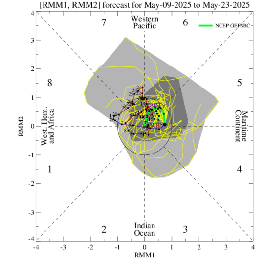
Looks like wxman57 broke into the MJO forecast laboratory last night...Big changes on the GFS MJO forecast. If this were to verify, this winter weather thread could come to an abrupt halt. Yikes!!

Image
0 likes   

User avatar
Portastorm
Storm2k Moderator
Storm2k Moderator
Posts: 9914
Age: 63
Joined: Fri Jul 11, 2003 9:16 am
Location: Round Rock, TX
Contact:

Re: Texas Winter 2012-2013

#3788 Postby Portastorm » Tue Feb 05, 2013 10:27 am

orangeblood, I shared that concern yesterday with Ntxw. The lessen amplitude of the MJO could indeed have consequences in terms of the real weather. However, that is a GFS prog and I'm honestly not aware of how well the GFS forecasts for the MJO have done. Do you know? Anyone?
0 likes   
Any forecasts under my name are to be taken with a grain of salt. Get your best forecasts from the National Weather Service and National Hurricane Center.

User avatar
wxman57
Moderator-Pro Met
Moderator-Pro Met
Posts: 22979
Age: 67
Joined: Sat Jun 21, 2003 8:06 pm
Location: Houston, TX (southwest)

Re: Texas Winter 2012-2013

#3789 Postby wxman57 » Tue Feb 05, 2013 10:30 am

OK, I'm back. Had to make a short trip to the MJO forecast lab overnight. I see that latest runs of the GFS backed off on the sub-freezing air for TX the 3rd week of February. And no more snow for central Florida at hour 384. Big surprise that disappeared on subsequent runs (after 18Z yesterday).
0 likes   

orangeblood
S2K Supporter
S2K Supporter
Posts: 3714
Joined: Tue Dec 15, 2009 6:14 pm
Location: Fort Worth, TX

Re: Texas Winter 2012-2013

#3790 Postby orangeblood » Tue Feb 05, 2013 10:57 am

Portastorm wrote:orangeblood, I shared that concern yesterday with Ntxw. The lessen amplitude of the MJO could indeed have consequences in terms of the real weather. However, that is a GFS prog and I'm honestly not aware of how well the GFS forecasts for the MJO have done. Do you know? Anyone?


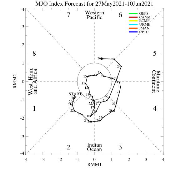
The good news is that it doesn't have a lot of support from the other models but all models do take the MJO down towards the circle of death over the next 2-3 days then the other models re-amplify the wave after that. Here is a comparison of all MJO models

Image

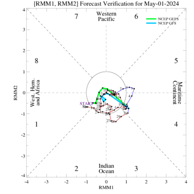
And here is the GFS MJO forecast verification over the past week...not too terrible

Image
0 likes   

User avatar
wxman57
Moderator-Pro Met
Moderator-Pro Met
Posts: 22979
Age: 67
Joined: Sat Jun 21, 2003 8:06 pm
Location: Houston, TX (southwest)

Re: Texas Winter 2012-2013

#3791 Postby wxman57 » Tue Feb 05, 2013 11:46 am

Nothing in the 12Z GFS to suggest any major cold or frozen precip for Texas over the next 2 weeks. In fact, it doesn't even show any freezing temps for Dallas-Ft. Worth through the 21st. A light freeze down to the Red River next Tuesday is about it.
0 likes   

orangeblood
S2K Supporter
S2K Supporter
Posts: 3714
Joined: Tue Dec 15, 2009 6:14 pm
Location: Fort Worth, TX

Re: Texas Winter 2012-2013

#3792 Postby orangeblood » Tue Feb 05, 2013 12:12 pm

wxman57 wrote:Nothing in the 12Z GFS to suggest any major cold or frozen precip for Texas over the next 2 weeks. In fact, it doesn't even show any freezing temps for Dallas-Ft. Worth through the 21st. A light freeze down to the Red River next Tuesday is about it.


Come on wxman57, you know better than anybody on here that, if you model hug the GFS model for too long, you'll get burned!! Go check out last night's Euro control run and you'll be singing a different tune
0 likes   

User avatar
wxman57
Moderator-Pro Met
Moderator-Pro Met
Posts: 22979
Age: 67
Joined: Sat Jun 21, 2003 8:06 pm
Location: Houston, TX (southwest)

Re: Texas Winter 2012-2013

#3793 Postby wxman57 » Tue Feb 05, 2013 12:32 pm

orangeblood wrote:
wxman57 wrote:Nothing in the 12Z GFS to suggest any major cold or frozen precip for Texas over the next 2 weeks. In fact, it doesn't even show any freezing temps for Dallas-Ft. Worth through the 21st. A light freeze down to the Red River next Tuesday is about it.


Come on wxman57, you know better than anybody on here that, if you model hug the GFS model for too long, you'll get burned!! Go check out last night's Euro control run and you'll be singing a different tune


My original statement was just a statement of fact, not a forecast. It is a fact that the 12Z GFS isn't forecasting any significant cold for Texas for 2 weeks. That's all I said. There was no implied forecast.

However, I would love to believe it. Can't trust the Euro, particularly when it shows cold air for Houston. ;-)
0 likes   

User avatar
Ntxw
Storm2k Moderator
Storm2k Moderator
Posts: 22786
Joined: Wed Oct 21, 2009 6:34 pm
Location: DFW, Texas

#3794 Postby Ntxw » Tue Feb 05, 2013 12:46 pm

Don't get too worried about the MJO guys, it's not going to fight the cold teleconnections. AO should go negative tomorrow and EPO negative to very negative next week. As I said earlier GFS is not the model of choice for ejection of systems, euro is. GFS has been a good indicator of long term pattern changes which it has already done I'll give it that.

MJO will re-flare over the IO (p2-3), that is the birthplace of most waves as mentioned in the tropical thread
0 likes   
The above post and any post by Ntxw is NOT an official forecast and should not be used as such. It is just the opinion of the poster and may or may not be backed by sound meteorological data. It is NOT endorsed by any professional institution including Storm2k. For official information, please refer to NWS products.


  Help support Storm2K!

Help Support Storm2K


User avatar
Ntxw
Storm2k Moderator
Storm2k Moderator
Posts: 22786
Joined: Wed Oct 21, 2009 6:34 pm
Location: DFW, Texas

#3795 Postby Ntxw » Tue Feb 05, 2013 1:26 pm

Also anyone look out their window lately? Cloudy to partly cloudy the last two days and much of this week with varying chances of rain for Texas. Warm but an unpleasant warm for wxman57. Look familiar? Think SOI crash like in mid December after the heatwave
0 likes   
The above post and any post by Ntxw is NOT an official forecast and should not be used as such. It is just the opinion of the poster and may or may not be backed by sound meteorological data. It is NOT endorsed by any professional institution including Storm2k. For official information, please refer to NWS products.


  Help support Storm2K!

Help Support Storm2K


orangeblood
S2K Supporter
S2K Supporter
Posts: 3714
Joined: Tue Dec 15, 2009 6:14 pm
Location: Fort Worth, TX

Re: Texas Winter 2012-2013

#3796 Postby orangeblood » Tue Feb 05, 2013 2:15 pm

12Z Euro has the southern plains winter storm back on the map for next Tuesday, actually a very potent storm from the southern plains to the mid-atlantic. Then drops another storm down into the southern rockies late next week. It's ridiculous how far apart the GFS and Euro are with their upper level patterns.
0 likes   

User avatar
Ntxw
Storm2k Moderator
Storm2k Moderator
Posts: 22786
Joined: Wed Oct 21, 2009 6:34 pm
Location: DFW, Texas

#3797 Postby Ntxw » Tue Feb 05, 2013 2:15 pm

12z euro hm how interesting for the Red River valley next week
0 likes   
The above post and any post by Ntxw is NOT an official forecast and should not be used as such. It is just the opinion of the poster and may or may not be backed by sound meteorological data. It is NOT endorsed by any professional institution including Storm2k. For official information, please refer to NWS products.


  Help support Storm2K!

Help Support Storm2K


User avatar
wxman57
Moderator-Pro Met
Moderator-Pro Met
Posts: 22979
Age: 67
Joined: Sat Jun 21, 2003 8:06 pm
Location: Houston, TX (southwest)

Re:

#3798 Postby wxman57 » Tue Feb 05, 2013 3:57 pm

Ntxw wrote:12z euro hm how interesting for the Red River valley next week


On the 24hr snow accumulations map from the 12Z Euro I see some light accumulations down to the southern Panhandle and eastward along the Red River to a good bit west of Wichita Falls next Tuesday. Probably nothing for the Dallas area but cannot absolutely rule out the chance of a snowflake that far south (yet). I still don't think the Dallas area will see any more snow this winter.
0 likes   

User avatar
CaptinCrunch
S2K Supporter
S2K Supporter
Posts: 8728
Age: 57
Joined: Mon Nov 03, 2003 4:33 pm
Location: Kennedale, TX (Tarrant Co.)

Re: Texas Winter 2012-2013

#3799 Postby CaptinCrunch » Tue Feb 05, 2013 4:29 pm

AREA FORECAST DISCUSSION
NATIONAL WEATHER SERVICE FORT WORTH TX
254 PM CST TUE FEB 5 2013


.DISCUSSION...
LOW CLOUDS WILL RETURN ONCE AGAIN TONIGHT...BUT WITH INCREASING
BOUNDARY LAYER WINDS (20-25KT AT 925MB BEFORE MORNING) LOW LEVEL
MIXING SHOULD BE A BIT STRONGER HELPING TO LIMIT DENSE FOG. EARLY
LOW CLOUD COVERAGE WILL ALSO LIMIT RADIATIONAL COOLING AND WORK
AGAINST FOG AS WELL...SO I DO NOT SEE ANY WELL-DEFINED AREAS FOR
DENSE FOG.

UPPER DISTURBANCE MOVING ACROSS SOUTH CENTRAL TEXAS TOMORROW PUTS
NORTH TEXAS ON THE NORTHERN EDGE OF THE PRECIPITATION SHIELD.
SHOWERS SHOULD DEVELOP IN THE MORNING ACROSS SOUTHERN
COUNTIES...AND WITH MODEST CAPE BY LATE AFTERNOON SOME
THUNDERSTORMS SHOULD ENTER THE MIX. A SECOND SHORT WAVE PUSHING
ACROSS OKLAHOMA ON THE HEELS OF THE COASTAL WAVE WILL EXTEND POPS
INTO THURSDAY WITH LINGERING POPS IN THE NORTHEAST THROUGH SUNRISE
FRIDAY.

A STRONG CUTOFF LOW PUSHES INTO THE GREAT BASIN FRIDAY
AFTERNOON...WITH THE GFS FARTHER SOUTHWEST THAN THE CANADIAN AND
ECMWF. AS LOW CONTINUES ITS PROGRESSION DURING THE
WEEKEND...PRECIPITATION IS EXPECTED SATURDAY AND SUNDAY. GFS
BECOMES A SOUTHERN OUTLIER...CENTERING THE 500MB LOW IN COLORADO
NOON SUNDAY WHILE THE ECMWF AND CANADIAN HAVE MOVED IT INTO NW
IOWA. THE CANADIAN KEEPS NORTH TEXAS DRY ON SATURDAY...BUT THE
GFS/ECMWF PRODUCE FAIRLY WIDESPREAD PRECIP AND HAVE ELECTED TO
KEEP CHANCE POPS IN THE FORECAST.

WITH THE WARM FLOW FROM THE GULF...TEMPERATURES WILL STAY ABOVE
CLIMATOLOGICAL NORMALS THROUGH THE WEEKEND. A COLD FRONT PROGGED
TO SWEEP THROUGH THE AREA MONDAY WILL COOL TEMPS EARLY NEXT WEEK
BACK TO OR BELOW SEASONAL NORMS
.
0 likes   

User avatar
Ntxw
Storm2k Moderator
Storm2k Moderator
Posts: 22786
Joined: Wed Oct 21, 2009 6:34 pm
Location: DFW, Texas

Re: Re:

#3800 Postby Ntxw » Tue Feb 05, 2013 4:39 pm

wxman57 wrote:
Ntxw wrote:12z euro hm how interesting for the Red River valley next week


On the 24hr snow accumulations map from the 12Z Euro I see some light accumulations down to the southern Panhandle and eastward along the Red River to a good bit west of Wichita Falls next Tuesday. Probably nothing for the Dallas area but cannot absolutely rule out the chance of a snowflake that far south (yet). I still don't think the Dallas area will see any more snow this winter.


It is still 7 days away and I do like what it is hinting at. Things are close enough and set up well enough that things can get interesting. Get us a stronger shortwave coming out of west Texas and a wrapped up system, I might still yet win the bet ;)
0 likes   
The above post and any post by Ntxw is NOT an official forecast and should not be used as such. It is just the opinion of the poster and may or may not be backed by sound meteorological data. It is NOT endorsed by any professional institution including Storm2k. For official information, please refer to NWS products.


  Help support Storm2K!

Help Support Storm2K


Return to “Winter Weather”

Who is online

Users browsing this forum: No registered users and 10 guests