Texas winter weather thread #2 - winter weather on Friday?
Moderator: S2k Moderators
Forum rules
 The posts in this forum are NOT official forecast and should not be used as such. They are just the opinion of the poster and may or may not be backed by sound meteorological data. They are NOT endorsed by any professional institution or STORM2K.

The posts in this forum are NOT official forecast and should not be used as such. They are just the opinion of the poster and may or may not be backed by sound meteorological data. They are NOT endorsed by any professional institution or STORM2K.

-
cheezyWXguy

- Category 5

- Posts: 6280
- Joined: Mon Feb 13, 2006 12:29 am
- Location: Dallas, TX
-
gatorcane

- S2K Supporter

- Posts: 23708
- Age: 48
- Joined: Sun Mar 13, 2005 3:54 pm
- Location: Boca Raton, FL
a weather channel graphic shows above normal temps for Dec - Jan for much of the midwest through the central part of the US and west.
http://www.weather.com/maps/maptype/ten ... =undefined
I see NO evidence of this right now.
http://www.weather.com/maps/maptype/ten ... =undefined
I see NO evidence of this right now.
0 likes
-
cheezyWXguy
- Category 5
- Posts: 6280
- Joined: Mon Feb 13, 2006 12:29 am
- Location: Dallas, TX
gatorcane wrote:a weather channel graphic shows above normal temps for Dec - Jan for much of the midwest through the central part of the US and west.
http://www.weather.com/maps/maptype/ten ... =undefined
I see NO evidence of this right now.
sure...not right now...but that outlook is for the next 2 months...not for the week...its quite poosible it could warm up a lot over the central protions of the U.S...however i dont think itll get that warm
0 likes
-
Extremeweatherguy

- Category 5
- Posts: 11095
- Joined: Mon Oct 10, 2005 8:13 pm
- Location: Florida
IAH is right on the edge of breaking a record this morning. Currently they are at 32F, and they need to break 31F to make it. It will be a close one for sure, but at this point a tie at least looks likely.
The 6am temperatures at other locations are...
Tomball = 31F
Conroe = 31F
Huntsville = 27F
College Station = 27F
Hobby = 35F
And though these numbers are cold, they are not nearly as cold as we had the potential to be. If winds would have died down more (they stayed up around 5mph last night), then we could have been up to 2-5 degrees colder.
BTW: This is the 3rd official freeze at IAH so far this season.
0 likes
-
Extremeweatherguy
- Category 5
- Posts: 11095
- Joined: Mon Oct 10, 2005 8:13 pm
- Location: Florida
-
Yankeegirl

- Category 5
- Posts: 3417
- Age: 50
- Joined: Sun May 23, 2004 11:59 pm
- Location: Cy-Fair, Northwest Houston
- Contact:
-
CaptinCrunch

- S2K Supporter
- Posts: 8776
- Age: 57
- Joined: Mon Nov 03, 2003 4:33 pm
- Location: Kennedale, TX (Tarrant Co.)
-
Portastorm

- Storm2k Moderator

- Posts: 9954
- Age: 63
- Joined: Fri Jul 11, 2003 9:16 am
- Location: Round Rock, TX
- Contact:
-
cctxhurricanewatcher

- Category 5
- Posts: 1206
- Joined: Sun Sep 12, 2004 8:53 pm
- Location: Corpus Christi, Texas
-
Yankeegirl
- Category 5
- Posts: 3417
- Age: 50
- Joined: Sun May 23, 2004 11:59 pm
- Location: Cy-Fair, Northwest Houston
- Contact:
-
jasons2k

- Storm2k Executive

- Posts: 8290
- Age: 52
- Joined: Wed Jul 06, 2005 12:32 pm
- Location: The Woodlands, TX
It is supposed to shift east but not by much. Overnight the axis is still pretty much at our longitude or slightly east, depending on which map you look at.
I'm afraid it won't matter much. Without a pressure gradient to speak of, at sunset winds will go calm and with low dewpoints, I expect tonight to easily be the coldest night so far this season.
I'm afraid it won't matter much. Without a pressure gradient to speak of, at sunset winds will go calm and with low dewpoints, I expect tonight to easily be the coldest night so far this season.
0 likes
-
PTrackerLA

- Category 5
- Posts: 5281
- Age: 42
- Joined: Thu Oct 10, 2002 8:40 pm
- Location: Lafayette, LA
-
southerngale

- Retired Staff

- Posts: 27418
- Joined: Thu Oct 10, 2002 1:27 am
- Location: Southeast Texas (Beaumont area)
They just issued a freeze warning for here. Our low is supposed to be 25° or 26° tonight.
Freeze Warning
URGENT - WEATHER MESSAGE
NATIONAL WEATHER SERVICE LAKE CHARLES LA
150 PM CST MON DEC 4 2006
...A HARD FREEZE IS EXPECTED TONIGHT NIGHT INTO EARLY TUESDAY
MORNING ACROSS INTERIOR SOUTHEAST TEXAS AND CENTRAL LOUISIANA...
.A HIGH PRESSURE CENTER OVER NORTHERN LOUISIANA TONIGHT WILL
PRODUCE CLEAR SKIES...CALM WINDS AND COLD TEMPERATURES.
LAZ041>045-051>055-TXZ215-216-051400-
/O.EXB.KLCH.FZ.W.0004.061205T0600Z-061205T1400Z/
CALCASIEU-JEFFERSON DAVIS-ACADIA-LAFAYETTE-UPPER ST. MARTIN-
CAMERON-VERMILION-IBERIA-ST. MARY-LOWER ST. MARTIN-JEFFERSON-
ORANGE-
INCLUDING THE CITIES OF...LAKE CHARLES...JENNINGS...CROWLEY...
LAFAYETTE...ST. MARTINVILLE...CAMERON...ABBEVILLE...NEW IBERIA...
MORGAN CITY...BEAUMONT/PORT ARTHUR...ORANGE
150 PM CST MON DEC 4 2006
...FREEZE WARNING IN EFFECT FROM MIDNIGHT TONIGHT TO 8 AM CST
TUESDAY...
THE NATIONAL WEATHER SERVICE IN LAKE CHARLES HAS ISSUED A HARD FREEZE
WARNING FOR AREAS OF SOUTHEAST TEXAS AND SOUTHERN LOUISIANA NORTH
OF I-10...AND A FIRST FREEZE WARNING FOR AREAS SOUTH OF I-10 TO
THE COAST.
CLEAR SKIES...LOW HUMIDITIES...AND CALM WINDS WILL BE IN PLACE...
RESULTING IN ACCELERATED RADIATIONAL COOLING. TEMPERATURES ARE
EXPECTED TO FALL BELOW FREEZING AROUND MIDNIGHT...LEVELING OFF IN
THE MID TO UPPER 20S JUST BEFORE DAWN ON TUESDAY FOR AREAS NORTH
OF I-10...WHICH WILL RESULT IN 8 TO 10 HOURS OF SUB-FREEZING
TEMPERATURES. AREAS SOUTH OF I-10 TO THE COAST...TEMPERATURES ARE
EXPECTED TO FALL BELOW FREEZING AFTER MIDNIGHT... LEVELING OFF IN
THE UPPER 20S TO NEAR 32 ALONG THE COAST JUST BEFORE DAWN.
A FREEZE WARNING MEANS SUB-FREEZING TEMPERATURES ARE IMMINENT OR
HIGHLY LIKELY. THESE CONDITIONS WILL KILL CROPS AND OTHER
SENSITIVE VEGETATION.
BE ESPECIALLY CAUTIOUS WHEN USING INDOOR SPACE HEATERS...AS MANY
HOME FIRES ARE ATTRIBUTED TO FAULTY HEATERS...OR HEATERS PLACED
TOO CLOSE TO FURNITURE OR CURTAINS.
0 likes
-
Extremeweatherguy
- Category 5
- Posts: 11095
- Joined: Mon Oct 10, 2005 8:13 pm
- Location: Florida
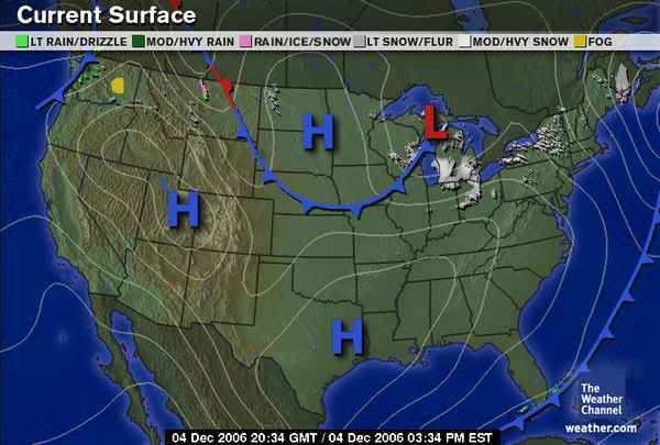
yeah, I am worried too. The high is still sitting right over us this afternoon and we have dewpoints in the TEENS! If that high doesn't move, then with good radaitional cooling..the coldest night of the season seems very likely (may be even a hard freeze).jschlitz wrote:I am nervous about tonight. I've been lucky so far this winter only getting to 31F - I am praying that somehow that High gets far enough east to swing our winds around but it doesn't look promising - and with dewpoints in the low 20's now - all I can say is
We will have to see what the NWS says in their afternoon AFD.
Afternoon High pressure location:
0 likes
-
gboudx

- S2K Supporter
- Posts: 4090
- Joined: Thu Sep 04, 2003 1:39 pm
- Location: Rockwall, Tx but from Harvey, La
Here's a definition of dew point. http://en.wikipedia.org/wiki/Dew_point
Basically, the lower the dew point, the lower the air temp can drop before reaching the saturation point. And if I'm understanding the definition correctly, then at saturation the air temp cannot go lower than the dew point.
Basically, the lower the dew point, the lower the air temp can drop before reaching the saturation point. And if I'm understanding the definition correctly, then at saturation the air temp cannot go lower than the dew point.
0 likes
-
PTrackerLA
- Category 5
- Posts: 5281
- Age: 42
- Joined: Thu Oct 10, 2002 8:40 pm
- Location: Lafayette, LA
-
jasons2k
- Storm2k Executive
- Posts: 8290
- Age: 52
- Joined: Wed Jul 06, 2005 12:32 pm
- Location: The Woodlands, TX
Yes, that's correct. The air temperature cannot go lower than the dewpoint.
Also, the dewpoint is a measure of how much moisture is in the air. Water heats and cools slower than air - so if the dewpoint is very dry - the atmosphere can heat and cool more quickly. The greater the temperature/dewpoint spread; the greater the ability for the atmosphere can heat/cool. That's why the diurnal range in deserts is much greater than in humid regions. The arid air of the desert can heat and cool more efficiently than humid, soupy air.
In today's case, the dewpoint (and also RH values, but that's another explanation) is very low - the air is very dry - so as soon as the sun sets, the temperature can fall at a faster rate. Hope this helps.
0 likes
Who is online
Users browsing this forum: TomballEd and 89 guests