Texas winter wx thread (2009-2010)

Winter Weather Discussion

Moderator: S2k Moderators

Forum rules

The posts in this forum are NOT official forecast and should not be used as such. They are just the opinion of the poster and may or may not be backed by sound meteorological data. They are NOT endorsed by any professional institution or STORM2K.

Help Support Storm2K
Message
Author
User avatar
iorange55
Category 5
Category 5
Posts: 2388
Joined: Thu Nov 13, 2008 9:47 pm
Location: Big D

Re: Texas winter wx thread (2009-2010)

#3921 Postby iorange55 » Mon Jan 11, 2010 11:23 pm

wxman22 wrote:0z GFS looks "Blah" shall I say more?... Confused Though still too early and models could be underestimating the strength of the system I guess will find out once the system moves ashore the west coast...


Stronger further north it more than likely pulls down that cold air in the rockies, but if it's further south like the models are showing then no fun at all. Let's hope it changes although it has been sort of consistent with shoving it south, boo.
0 likes   

User avatar
Big O
Category 1
Category 1
Posts: 252
Age: 55
Joined: Sun Sep 16, 2007 4:40 pm
Location: McAllen, Texas

Re: Texas winter wx thread (2009-2010)

#3922 Postby Big O » Mon Jan 11, 2010 11:52 pm

Long-term modeling is suggesting that the AO and EPO will go negative in late January. February may, in fact, turn out to be our coldest and perhaps snowiest month this winter. We shall se. :wink:
0 likes   

User avatar
iorange55
Category 5
Category 5
Posts: 2388
Joined: Thu Nov 13, 2008 9:47 pm
Location: Big D

Re: Texas winter wx thread (2009-2010)

#3923 Postby iorange55 » Mon Jan 11, 2010 11:54 pm

Big O wrote:Long-term modeling is suggesting that the AO and EPO will go negative in late January. February may, in fact, turn out to be our coldest and perhaps snowiest month this winter. We shall se. :wink:


Noticed a lot more cold air, and storminess late in the model run toward the 28th. Looks like one more maybe storm this weekend, and then a 2 week break, or so.
0 likes   

User avatar
Ntxw
Storm2k Moderator
Storm2k Moderator
Posts: 22795
Joined: Wed Oct 21, 2009 6:34 pm
Location: DFW, Texas

#3924 Postby Ntxw » Mon Jan 11, 2010 11:59 pm

I don't want to jinx it or anything, but we're still behind on ice storms. Past few Januaries have given us most of our ice.
0 likes   
The above post and any post by Ntxw is NOT an official forecast and should not be used as such. It is just the opinion of the poster and may or may not be backed by sound meteorological data. It is NOT endorsed by any professional institution including Storm2k. For official information, please refer to NWS products.

  Help support Storm2K!
Help Support Storm2K

User avatar
srainhoutx
S2K Supporter
S2K Supporter
Posts: 6919
Age: 67
Joined: Sun Jan 14, 2007 11:34 am
Location: Haywood County, NC
Contact:

Re: Texas winter wx thread (2009-2010)

#3925 Postby srainhoutx » Tue Jan 12, 2010 7:36 am

Looks like the ECMWF will be the choice of the HPC via the QPF Morning Update regarding the late week storm form now...

...TEXAS...

A SRN STREAM UPPER TROF IS EXPECTED TO LIFT OUT INTO CNTRL/ERN TX
IN RESPONSE TO UPSTREAM HEIGHT FALLS. THIS SRN STREAM ENERGY
SHOULD FOSTER THE DEVELOPMENT OF A LOW LVL INVERTED TROF ALONG OR
JUST OFFSHORE THE TX COASTLINE WHICH WILL ALLOW GULF MOISTURE TO
BEGIN TO SPREAD NWD. EXPECT AN INCREASE IN SHWR ACTIVITY BY LATE
WED ACRS FAR S TX...AND THEN MORE WIDESPREAD SHWR ACTIVITY THURS
AS LOW OVER NRN MEX ADVANCES EWD AND INFLOW FROM THE GULF
INCREASES. WIDESPREAD MDT TO LOCALLY HVY AMTS ARE EXPECTED ACROSS
MUCH OF S TX...PARTICULARLY ALONG THE GULF COAST BY EARLY FRI. IN
ADDITION TO STRONG GULF INFLOW...GUIDANCE ALSO INDICATED THE
PRESENCE OF STRONG UPR LVL DIVERGENCE...WHICH WILL BE AFFORDED BY
LEFT-EXIT REGION JET DYNAMICS...ACROSS THE REGION. THE GFS
APPEARS TO DEVELOP SOME FEEDBACK ISSUES...SPINNING UP A SFC LOW
AND QPF BULLSEYE ALONG THE LWR TX COAST. THE NAM REMAINS SLOWER
AND IS FURTHER TO THE N WITH THE MID LVL LOW TRACK THAN THE
REMAINING MODELS. THEREFORE...USED THE ECMWF AS A STARTING POINT
FOR THE MANUAL FORECAST LATE IN THE PERIOD.

ECKERT/PEREIRA


Image
0 likes   
Carla/Alicia/Jerry(In The Eye)/Michelle/Charley/Ivan/Dennis/Katrina/Rita/Wilma/Ike/Harvey

Member: National Weather Association
Wx Infinity Forums
http://wxinfinity.com/index.php

Facebook.com/WeatherInfinity
Twitter @WeatherInfinity

User avatar
txagwxman
Professional-Met
Professional-Met
Posts: 960
Joined: Thu Dec 24, 2009 3:26 pm
Location: Tomball, TX

#3926 Postby txagwxman » Tue Jan 12, 2010 8:10 am

ECMWF still too warm for snow...going to be a big rain maker only. 5" along the coast...lovely.

Well at least it has been dry for the last 11 days.
I have 70F late next week Houston...but we will see some cold again in late Jan/early Feb...
0 likes   
“If you thought that science was certain - well, that is just an error on your part.”

User avatar
srainhoutx
S2K Supporter
S2K Supporter
Posts: 6919
Age: 67
Joined: Sun Jan 14, 2007 11:34 am
Location: Haywood County, NC
Contact:

Re:

#3927 Postby srainhoutx » Tue Jan 12, 2010 8:17 am

txagwxman wrote:ECMWF still too warm for snow...going to be a big rain maker only. 5" along the coast...lovely.

Well at least it has been dry for the last 11 days.
I have 70F late next week Houston...but we will see some cold again in late Jan/early Feb...


The Stratospheric Warming (SSW) continues to show up via guidance and suggests you are correct that Late January/early February brings back the cold as blocking is reestablished.
0 likes   
Carla/Alicia/Jerry(In The Eye)/Michelle/Charley/Ivan/Dennis/Katrina/Rita/Wilma/Ike/Harvey

Member: National Weather Association
Wx Infinity Forums
http://wxinfinity.com/index.php

Facebook.com/WeatherInfinity
Twitter @WeatherInfinity

User avatar
srainhoutx
S2K Supporter
S2K Supporter
Posts: 6919
Age: 67
Joined: Sun Jan 14, 2007 11:34 am
Location: Haywood County, NC
Contact:

Re: Texas winter wx thread (2009-2010)

#3928 Postby srainhoutx » Tue Jan 12, 2010 8:30 am

I'll repost the morning e-mail from Jeff in the TX Winter Topic as it has significance to areas beyond SE TX...

Significant storm system to impact the area at the end of the week.


Old cold arctic high pressure moving off to the east this morning with weak onshore flow returning. Weak trough will be moving into SW TX today and Wednesday with moisture starting to return. Powerful upper level storm system will quickly follow into NW MX and then deepen over NE MX and SW TX on Thursday producing a threat of very heavy rains, strong winds, and coastal flooding along the TX coast.


Moisture return will begin in earnest Wednesday as southerly flow overruns the retreating cold dome at the surface. Isentropic processes begin to increase clouds and possibly light rainfall by Wednesday evening. Early Thursday the potent upper storm over MX begins to close off from the main flow while spreading strong forcing eastward over the TX coastal areas. At the surface an intense coastal surface low will develop off the lower TX coast under deep layer forcing and developing deep convection. GFS has trended weaker and more S and E with this feature over the past 24 hours however the ECMWF and CMC show the low much closer to the coast. At this point will split the difference on the tracks and show the system of 1002-1006mb tracking from near Padre Island to offshore of Matagorda Bay and then ENE toward offshore of Sabine Pass. Development of intense convection over the offshore waters may help to deepen this surface low even more as the GFS was showing yesterday (997mb). Very deep upper low pulls across on Saturday as coastal low moves on into LA. Expect extensive wrap around clouds and rainfall under strong cold air advection regime on the backside of the surface low. Critical thickness are not cold enough for anything frozen and will keep everything as a cold rain at this time.


Impacts:


Rainfall:

System looks very wet with moisture levels increasing to around 180% above mid Jan normals. This would normally raise red flags for a flooding threat as the magic % above normal is around 200%. PWS rising to near 1.2 inches by early Friday along with maximum lift from 600am to 600pm Friday point toward a very wet day across the southern ½ of the area. Feel bands of heavy rainfall will move SW to NE over the region on the north side of the coastal low as it passes offshore. Widespread amounts of 1-3 inches look reasonable with isolated totals of 5 inches possible. Lack of significant rains in December as allowed grounds at least up top to dry some however given the time of year and lack of any vegetation there will be good run-off produced by this event. 3-hour flash flood guidance is around 3” along the coastal counties and closer to 4 inches over the inland counties while 6-hour guidance is around 3.5” over the coastal sections and 4.0 inches elsewhere. Current HPC QPF amounts do not exceed the shorter duration guidance, but I suspect given the amount of moisture and dynamics with this system several hours of .5-1.5 inches over a 24 hour period could run up some decent totals and result in some good run-off. Appears the event will be more of a widespread moderate to heavy rainfall over a large area which tends to focus more issues toward the larger river basins than the smaller creeks and bayous. Too early to determine for sure the exact location of the heaviest rainfall and totals.


Coastal Flooding:

Fairly intense coastal low event for winter along the TX coast. Conditions will be similar to a tropical storm based on the GFS and ECMWF solutions this morning. Surface pressure falls into the low to middle 1000’s support very breezy conditions over the waters and along the coast. Looks good for sustained gale conditions in all of our coastal waters starting late Thursday and continuing into early Saturday with the possibly of border line storm conditions (55mph+) for the outer waters on Friday especially if the previous sub 1000mb GFS progs turn out to be correct. Strong E to ENE winds on the north side of the surface low will result in long fetch wind flow toward the coast, favorable Ekman transport, and building swells. Extra-tropical storm surge model run off the GFS with its track suggests water level rise of 1-2 feet along the beaches. Expect overall tides to run 2-3 feet above normal Thursday PM-Friday PM, and this could cause some issued on the very vulnerable Bolivar peninsula, west end of Galveston, upper Brazoria County, and the west sides of Matagorda and Galveston Bays. Coastal Flood Watch will likely be needed on Wednesday to cover this aspect.


Winds:

Breezy easterly winds will develop Thursday and increase into Friday and Saturday while over time backing to the NE and eventually the NW as the coastal low moves into and pass the region. Coastal winds will be sustained in the 25-30mph range with gust to 40mph while inland winds of 15-25mph with gust to 35mph will be likely especially on Friday.


As additional model runs become available changes to these impacts will be made. Track and intensity of the coastal surface low will result in changing impacts over the next 48 hours.
0 likes   
Carla/Alicia/Jerry(In The Eye)/Michelle/Charley/Ivan/Dennis/Katrina/Rita/Wilma/Ike/Harvey

Member: National Weather Association
Wx Infinity Forums
http://wxinfinity.com/index.php

Facebook.com/WeatherInfinity
Twitter @WeatherInfinity

User avatar
wxman22
Category 5
Category 5
Posts: 1505
Joined: Mon Jan 30, 2006 12:39 am
Location: Wichita Falls, TX
Contact:

Re: Texas winter wx thread (2009-2010)

#3929 Postby wxman22 » Tue Jan 12, 2010 9:17 am

What will be the first model runs to have RAOBS data of the system?
0 likes   

User avatar
srainhoutx
S2K Supporter
S2K Supporter
Posts: 6919
Age: 67
Joined: Sun Jan 14, 2007 11:34 am
Location: Haywood County, NC
Contact:

Re: Texas winter wx thread (2009-2010)

#3930 Postby srainhoutx » Tue Jan 12, 2010 9:25 am

wxman22 wrote:What will be the first model runs to have RAOBS data of the system?


00Z's tonight will have some. Tomorrow we will likely see much more data ingested into the dataset IMHO.
0 likes   
Carla/Alicia/Jerry(In The Eye)/Michelle/Charley/Ivan/Dennis/Katrina/Rita/Wilma/Ike/Harvey

Member: National Weather Association
Wx Infinity Forums
http://wxinfinity.com/index.php

Facebook.com/WeatherInfinity
Twitter @WeatherInfinity

User avatar
txagwxman
Professional-Met
Professional-Met
Posts: 960
Joined: Thu Dec 24, 2009 3:26 pm
Location: Tomball, TX

Re: Texas winter wx thread (2009-2010)

#3931 Postby txagwxman » Tue Jan 12, 2010 1:06 pm

srainhoutx wrote:
wxman22 wrote:What will be the first model runs to have RAOBS data of the system?


00Z's tonight will have some. Tomorrow we will likely see much more data ingested into the dataset IMHO.

Won't be on the raobs until 12Z tomorrow.
Lot of rain/wind...
0 likes   
“If you thought that science was certain - well, that is just an error on your part.”

User avatar
Ntxw
Storm2k Moderator
Storm2k Moderator
Posts: 22795
Joined: Wed Oct 21, 2009 6:34 pm
Location: DFW, Texas

#3932 Postby Ntxw » Tue Jan 12, 2010 1:25 pm

Well for all of the sun lovers, the daily averages in Texas should be going up from this point on as well as a slow northern shift in the sun angle. Not too much longer :D
0 likes   
The above post and any post by Ntxw is NOT an official forecast and should not be used as such. It is just the opinion of the poster and may or may not be backed by sound meteorological data. It is NOT endorsed by any professional institution including Storm2k. For official information, please refer to NWS products.


  Help support Storm2K!

Help Support Storm2K


User avatar
Portastorm
Storm2k Moderator
Storm2k Moderator
Posts: 9914
Age: 63
Joined: Fri Jul 11, 2003 9:16 am
Location: Round Rock, TX
Contact:

Re:

#3933 Postby Portastorm » Tue Jan 12, 2010 1:53 pm

Ntxw wrote:Well for all of the sun lovers, the daily averages in Texas should be going up from this point on as well as a slow northern shift in the sun angle. Not too much longer :D


Actually I have to admit that after the cold ... today feels nice out there . Crisp blue skies, bright sunshine here in the capital of Texas during the lunch hour and temp pushing 60 degrees. :D
0 likes   

User avatar
srainhoutx
S2K Supporter
S2K Supporter
Posts: 6919
Age: 67
Joined: Sun Jan 14, 2007 11:34 am
Location: Haywood County, NC
Contact:

Re: Texas winter wx thread (2009-2010)

#3934 Postby srainhoutx » Tue Jan 12, 2010 4:35 pm

:uarrow: I agree 
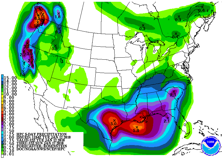
Portastorm. The warmth felt really nice today. FWD thoughts concering this powerful storm that looks to offer forecasting challenges in the days ahead...

AREA FORECAST DISCUSSION
NATIONAL WEATHER SERVICE FORT WORTH TX
217 PM CST TUE JAN 12 2010

.DISCUSSION...
STRONG ZONAL PACIFIC FLOW WILL RESULT IN A SERIES OF SOUTHERN
STREAM SHORTWAVE TROUGHS OVER THE NEXT SEVEN DAYS. FIRST UPPER TROUGH
ALREADY PRESENT TO OUR SOUTHWEST WITH CONSIDERABLE CLOUD COVER
ALONG THE RIO GRANDE THAT WILL SPREAD NORTH-NORTHEASTWARD
OVERNIGHT AND WEDNESDAY.

EASTERN PACIFIC UPPER LEVEL FLOW BUCKLES AND PRODUCES ANOTHER
STRONG SHORTWAVE ON WEDNESDAY AS A 140KT JET ARRIVES AND MOVES
DOWN THE WEST COAST. THIS TROUGH BECOMES A CLOSED LOW OVER
SOUTHWEST ARIZONA AND THEN DROPS DOWN INTO THE STATE OF DURAGO
BEFORE HOOKING BACK ACROSS FAR SOUTH TEXAS. THIS IS A VERY
IMPRESSIVE LOW LATITUDE UPPER LOW AND CONTINUES TO BE FORECAST AT
4 TO 5 STANDARDIZED ANOMALIES BELOW NORMAL ACROSS NORTH-CENTRAL
MEXICO. IT EJECTS OUT NORTHEAST ON SATURDAY AND BEGINS TO WEAKEN
LATE SUNDAY AS IT MERGES INTO CONFLUENT FLOW ALONG THE EAST COAST.

THE LOW LATITUDE POSITION OF THIS SYSTEM MEANS TI WILL BE ABLE TO TAP
LOW LEVEL GULF MOISTURE WITH AN 850MB CONVEYOR BELT (LLJ)
EXTENDING FROM SOUTH TEXAS...ALONG THE I-35 CORRIDOR AND INTO THE
NORTH TEXAS ON THURSDAY AS SURFACE CYCLOGENESIS STARTS IN
NORTHEAST MEXICO. 850MB DEWPOINTS OF 6-7 DEGREES COULD REACH WACO
BY MIDNIGHT THURSDAY. AS THE SURFACE LOW DEEPENS IN THE WESTERN
GULF AND BEGINS TO MOVE...FLOW ACROSS NORTH TEXAS WILL BACK TO THE
NORTHEAST FRIDAY NIGHT AND TO THE NORTH ON SATURDAY. STRONG
ISENTROPIC ASCENT AND DEEP OMEGA WILL BE PRESENT ACROSS MUCH OF
NORTH TEXAS THURSDAY NIGHT THROUGH FRIDAY NIGHT...AND IS THE MORE LIKELY
TIME PERIOD FOR MODERATE TO HEAVY RAINFALL THURSDAY NIGHT THROUGH
FRIDAY EVENING...AND MAYBE LOCALIZED RIVER FLOODING BY FRIDAY
NIGHT. INSTABILITY REMAINS VERY LOW OR NON- EXISTENCE...BUT
FORECAST SOUNDINGS OVER THE SOUTHERN 1/4 STILL IMPLY ISOLATED
THUNDER IS POSSIBLE DUE TO JET DYNAMICS AND DIVERGENCE ALOFT.

WE/RE FOLLOWING THE SLIGHTLY SLOWER ECMWF FOR THIS STORMS BASIC
TRACK AND ENDING OF PRECIPITATION SATURDAY NIGHT. ALSO...WE
CONTINUE TO UNDERCUT MOS HIGHS THURSDAY THROUGH SATURDAY.
NORMAL TEMPERATURES AND DRY WEATHER IS EXPECTED WEDNESDAY...AND
AGAIN SUNDAY. COULD SEE RAIN AGAIN NEXT TUESDAY AS YET ANOTHER
UPPER SHORTWAVE TRANSVERSES THE SOUTHERN PLAINS. 75
0 likes   
Carla/Alicia/Jerry(In The Eye)/Michelle/Charley/Ivan/Dennis/Katrina/Rita/Wilma/Ike/Harvey

Member: National Weather Association
Wx Infinity Forums
http://wxinfinity.com/index.php

Facebook.com/WeatherInfinity
Twitter @WeatherInfinity

attallaman

Re:

#3935 Postby attallaman » Tue Jan 12, 2010 4:37 pm

txagwxman wrote:ECMWF still too warm for snow...going to be a big rain maker only. 5" along the coast...lovely.

Well at least it has been dry for the last 11 days.
I have 70F late next week Houston...but we will see some cold again in late Jan/early Feb...
Will the cold be as cold as the cold we have just experienced?
0 likes   

User avatar
Ntxw
Storm2k Moderator
Storm2k Moderator
Posts: 22795
Joined: Wed Oct 21, 2009 6:34 pm
Location: DFW, Texas

Re: Re:

#3936 Postby Ntxw » Tue Jan 12, 2010 4:45 pm

attallaman wrote:
txagwxman wrote:ECMWF still too warm for snow...going to be a big rain maker only. 5" along the coast...lovely.

Well at least it has been dry for the last 11 days.
I have 70F late next week Houston...but we will see some cold again in late Jan/early Feb...
Will the cold be as cold as the cold we have just experienced?


There is tremendous cold air building again in NW Canada and Eastern Alaska. It's comparable to the last wave however, when and where it might dislodge is yet to be seen.

http://www.wunderground.com/US/Region/Alaska/2xTemperature.html
0 likes   
The above post and any post by Ntxw is NOT an official forecast and should not be used as such. It is just the opinion of the poster and may or may not be backed by sound meteorological data. It is NOT endorsed by any professional institution including Storm2k. For official information, please refer to NWS products.


  Help support Storm2K!

Help Support Storm2K


User avatar
srainhoutx
S2K Supporter
S2K Supporter
Posts: 6919
Age: 67
Joined: Sun Jan 14, 2007 11:34 am
Location: Haywood County, NC
Contact:

Re: Texas winter wx thread (2009-2010)

#3937 Postby srainhoutx » Tue Jan 12, 2010 5:00 pm

Corpus Christi Update...

AREA FORECAST DISCUSSION
NATIONAL WEATHER SERVICE CORPUS CHRISTI TX
352 PM CST TUE JAN 12 2010

.SHORT TERM...RELATIVELY QUIET WEATHER EXPECTED OVER THE SHORT
TERM COMPARED TO WHAT IS COMING LATER IN THE WEEK. WEAK
OVERRUNNING WILL PRODUCE LIGHT RAIN AND DRIZZLE ACROSS MUCH OF THE
CWFA OVER THE NEXT 36H...WITH THE ATTENDANT LOW CLOUDS AND
RELATIVELY SMALL DIURNAL RANGES. A SURFACE RIDGE AXIS EXTENDING
INTO NORTHEAST PART OF THE COASTAL BEND WILL GRADUALLY SHIFT
EAST...ALLOWING LOW CLOUDS TO EXTEND INTO THOSE AREAS AS
WELL...WITH INCREASED CHANGES FOR SMALL AMOUNTS OF RAIN THROUGH
WEDNESDAY NIGHT.

&&

.LONG TERM (THURSDAY THROUGH TUESDAY)...BIG RAIN MAKER IN THE FIRST
HALF OF THE LONG TERM. A VIGOROUS UPPER LEVEL LOW WILL WILL DIVE OUT
OF THE DESERT SOUTHWEST U.S. WEDNESDAY NIGHT DEEP INTO MEXICO ON
THURSDAY AND THURSDAY NIGHT...THEN LIFT NORTHEAST RIGHT THROUGH
SOUTH TEXAS LATE FRIDAY INTO EARLY SATURDAY. PRECIPITATION WILL BE
ON THE INCREASE AS EARLY AS DURING THE DAY ON THURSDAY...HOWEVER THE
MAIN EVENT WILL COME THURSDAY NIGHT INTO FRIDAY MORNING AS VERY
STRONG FORCING COMES RIGHT ACROSS SOUTH TEXAS...INTERACTING WITH
VERY MOIST/RICH GULF AIRMASS (PWS PROGGED 150-200% OF NORMAL). H7-H3
Q-V CONVERGENCE IS MAXED OUT RIGHT OVER SOUTH TEXAS BY BOTH THE
ECMWF AND GFS FRIDAY MORNING...AND A STRONGLY DIVERGENT UPPER LEVEL
PATTERN IS SHOWN GIVEN THE UPPER LEVEL LOW POSITION TO THE
SOUTHWEST. IN FACT...THE GFS/ECMWF/CANADIAN/UKMET ARE ALL IN
RELATIVELY GOOD AGREEMENT TODAY...AND HAVE BEEN INDICATING THIS
SCENARIO FOR THE PAST SEVERAL RUNS. THE NAM IS A SLIGHT OUTLIER AND
APPEARS DISPLACED WITH THE LOW LEVEL FEATURES AND QPF TOO FAR TO THE
NORTHWEST. AT ANY RATE...HAVE RAISED POPS TO LIKELY AND CATEGORICAL
THURSDAY NIGHT AND FRIDAY...WITH THE HEAVY RAINFALL THREATS
MENTIONED IN THE COASTAL BEND AND VICTORIA CROSSROADS ZONES
.


THE MAIN FORCING AND HEAVY RAINFALL POTENTIAL LIFTS NORTHEAST OF THE
CWA FRIDAY AFTERNOON AND EVENING...BUT SEVERAL OF THE MODELS ARE
INDICATING CONTINUED UPPER LEVEL FORCING FOR LIGHTER PRECIPITATION
CLOSER TO THE CORE AND BACK SIDE OF THE LOW AS IT COMES ACROSS LATE
FRIDAY...SO HAVE FORECASTED HIGH CHANCE TO LIKELY POPS INTO FRIDAY
NIGHT.


SEVERAL OF THE MODELS HAVE BEEN CONSISTENTLY SHOWING QPF BULLSEYES
WITH THIS EVENT PLACED ACROSS THE COASTAL BEND...BETWEEN CORPUS
CHRISTI AND VICTORIA. APPEARS TOTAL RAINFALL ACCUMULATIONS OF 4-6"
WITH ISOLATED AMOUNTS OF UP TO 10" ARE NOT OUT OF THE QUESTION
ACROSS THIS REGION IF THINGS SET UP RIGHT...WITH MOST OF IT FALLING
THURSDAY NIGHT AND FRIDAY MORNING. HPC HAS PLACED THIS REGION OF THE
CWA IN A SLIGHT RISK IN THE DAY 3 EXCESSIVE RAINFALL OUTLOOK.

LESSER AMOUNTS OF 1-3" ARE EXPECTED SOUTHWEST OF I-37 TO THE RIO
GRANDE. THERE WILL ALSO BE A SLIGHT POTENTIAL FOR SMALL HAIL MIXING
IN DURING THE DAY FRIDAY AS THE CORE OF COLD TEMPERATURES ALOFT
SPREAD INTO THE REGION...BUT THE SEVERE RISK AT THE MOMENT APPEARS
TOO LOW TO MENTION.


AS THE UPPER LEVEL LOW AND ASSOCIATED SURFACE LOW AND COLD FRONT
LIFT EAST OF THE REGION SATURDAY MORNING...PRECIPITATION CHANCES
WILL DIMINISH AS DRIER AIR WORKS INTO SOUTH TEXAS. IN ADDITION...
THERE WILL BE A PERIOD OF STRONG NORTHWEST FLOW...MAINLY ACROSS THE
EASTERN HALF OF THE CWA AND COASTAL WATERS...FRIDAY NIGHT THROUGH
MIDDAY SATURDAY. CLOUDS MAY ALSO STICK AROUND FOR A GOOD PORTION OF
THE DAY ACROSS THE NORTHEAST HALF OF THE CWA ON SATURDAY...BUT
CLEARING ACROSS THE ENTIRE CWA IS ANTICIPATED SATURDAY NIGHT.
GRADUAL WARMING TAKES PLACE MONDAY AND TUESDAY...WITH THE ECMWF AND
GFS INDICATING A WEAK SHORTWAVE MOVING ACROSS TEXAS ON TUESDAY. LOW
20 POPS ARE IN THE FORECAST FOR THE EASTERN CWA TUESDAY.

WILL REISSUE THE SPS FOR THIS HEAVY RAINFALL WITH DETAILS DISCUSSED
ABOVE.

Image
0 likes   
Carla/Alicia/Jerry(In The Eye)/Michelle/Charley/Ivan/Dennis/Katrina/Rita/Wilma/Ike/Harvey

Member: National Weather Association
Wx Infinity Forums
http://wxinfinity.com/index.php

Facebook.com/WeatherInfinity
Twitter @WeatherInfinity

User avatar
vbhoutex
Storm2k Executive
Storm2k Executive
Posts: 29113
Age: 73
Joined: Wed Oct 09, 2002 11:31 pm
Location: Cypress, TX
Contact:

Re: Texas winter wx thread (2009-2010)

#3938 Postby vbhoutex » Tue Jan 12, 2010 5:36 pm

The following post is NOT an official forecast and should not be used as such. It is just the opinion of the poster and may or may not be backed by sound meteorological data. It is NOT endorsed by any professional institution including storm2k.org. For official information, please refer to NWS products.
:uarrow: That definitely jives with what the models are showing. Here in SE TX it looks like we will get quite a spanking from the ULL as it lags behind the initial lighter rains brought on by the surface low out ahead and SE of it. Right now it appears the surface low will stay enough offshore to not be the real problem(ie. hopefully no double whammy)for SE TX as opposed to the ULL. Even though our year started off cold and dry the rain amounts being mentioned are going to cause a lot of run off issues imo and we all need to be watching for possible flooding or flash flooding problems. At this point I don't see how what the models are depicting are not going to verify pretty well as far as rain amounts go. Fortunately or unfortunately, depending on ones perspective, there is not enough cold air coming with this system to cause winter precip in our area or any of TX from what I see. Further down the road who knows? With more majorly cold air building in NW Canada we may be in for some more Arctic cold if the right set up dislodges some of that. Plenty of time to worry about that while we get through this system. Enjoy the "warm" and dry weather while we can. It appears we are still in for quite a ride this winter season in TX.
0 likes   
Skywarn, C.E.R.T.
Please click below to donate to STORM2K to help with the expenses of keeping the site going:
Image

User avatar
txagwxman
Professional-Met
Professional-Met
Posts: 960
Joined: Thu Dec 24, 2009 3:26 pm
Location: Tomball, TX

Re: Texas winter wx thread (2009-2010)

#3939 Postby txagwxman » Tue Jan 12, 2010 8:08 pm

CRP fcst discussion mentioning 10" of rain....I seriously doubt we will see that.
0 likes   
“If you thought that science was certain - well, that is just an error on your part.”

User avatar
srainhoutx
S2K Supporter
S2K Supporter
Posts: 6919
Age: 67
Joined: Sun Jan 14, 2007 11:34 am
Location: Haywood County, NC
Contact:

Re: Texas winter wx thread (2009-2010)

#3940 Postby srainhoutx » Tue Jan 12, 2010 11:22 pm

0 likes   
Carla/Alicia/Jerry(In The Eye)/Michelle/Charley/Ivan/Dennis/Katrina/Rita/Wilma/Ike/Harvey

Member: National Weather Association
Wx Infinity Forums
http://wxinfinity.com/index.php

Facebook.com/WeatherInfinity
Twitter @WeatherInfinity


Return to “Winter Weather”

Who is online

Users browsing this forum: No registered users and 25 guests