srainhoutx wrote:Hmmm...Where in the world did this come from over Kansas. A different GFS run and a different solution...
http://www.nco.ncep.noaa.gov/pmb/nwprod ... 0_072l.gif
http://www.nco.ncep.noaa.gov/pmb/nwprod ... 0_078l.gif
http://www.nco.ncep.noaa.gov/pmb/nwprod ... 0_084l.gif
http://www.nco.ncep.noaa.gov/pmb/nwprod ... 0_090l.gif
http://www.nco.ncep.noaa.gov/pmb/nwprod ... 0_096l.gif
http://www.nco.ncep.noaa.gov/pmb/nwprod ... 0_102l.gif
Texas winter wx thread (2009-2010)
Moderator: S2k Moderators
Forum rules
 The posts in this forum are NOT official forecast and should not be used as such. They are just the opinion of the poster and may or may not be backed by sound meteorological data. They are NOT endorsed by any professional institution or STORM2K.

The posts in this forum are NOT official forecast and should not be used as such. They are just the opinion of the poster and may or may not be backed by sound meteorological data. They are NOT endorsed by any professional institution or STORM2K.
-
serenata09
- Tropical Storm

- Posts: 166
- Joined: Fri Jan 18, 2008 7:55 pm
- Location: Dallas, TX
Re: Texas winter wx thread (2009-2010)
What is that depicting srain? This guy can't read models... 
0 likes
-
srainhoutx

- S2K Supporter

- Posts: 6919
- Age: 68
- Joined: Sun Jan 14, 2007 11:34 am
- Location: Haywood County, NC
- Contact:
Re: Texas winter wx thread (2009-2010)
serenata09 wrote:What is that depicting srain? This guy can't read models...srainhoutx wrote:Hmmm...Where in the world did this come from over Kansas. A different GFS run and a different solution...
http://www.nco.ncep.noaa.gov/pmb/nwprod ... 0_072l.gif
http://www.nco.ncep.noaa.gov/pmb/nwprod ... 0_078l.gif
http://www.nco.ncep.noaa.gov/pmb/nwprod ... 0_084l.gif
http://www.nco.ncep.noaa.gov/pmb/nwprod ... 0_090l.gif
http://www.nco.ncep.noaa.gov/pmb/nwprod ... 0_096l.gif
http://www.nco.ncep.noaa.gov/pmb/nwprod ... 0_102l.gif
Some of us have been commenting on just how many vortices are associated with this feature over the Pacific and how it may be wreaking havoc on guidance. Tonight we may be getting hints that things are far more complex than many folks have thought. This is one of the reason I have stated as well as others that we need to wait until this system gets onshore before we speculate how things may unfold.
0 likes
Carla/Alicia/Jerry(In The Eye)/Michelle/Charley/Ivan/Dennis/Katrina/Rita/Wilma/Ike/Harvey
Member: National Weather Association
Wx Infinity Forums
http://wxinfinity.com/index.php
Facebook.com/WeatherInfinity
Twitter @WeatherInfinity
Member: National Weather Association
Wx Infinity Forums
http://wxinfinity.com/index.php
Facebook.com/WeatherInfinity
Twitter @WeatherInfinity

The one in Kansas is no walk in the park either. It just comes out of nowhere! The madness...
0 likes
The above post and any post by Ntxw is NOT an official forecast and should not be used as such. It is just the opinion of the poster and may or may not be backed by sound meteorological data. It is NOT endorsed by any professional institution including Storm2k. For official information, please refer to NWS products.
Help support Storm2K!


Re: Texas winter wx thread (2009-2010)
thats why I gave up on trying to forecast this storm a day ago.
0 likes
-
serenata09
- Tropical Storm
- Posts: 166
- Joined: Fri Jan 18, 2008 7:55 pm
- Location: Dallas, TX
Re: Texas winter wx thread (2009-2010)
So would this phantom vortex over Kansas have more of an affect precipitation or temperature wise?
0 likes
-
Portastorm

- Storm2k Moderator

- Posts: 9955
- Age: 63
- Joined: Fri Jul 11, 2003 9:16 am
- Location: Round Rock, TX
- Contact:
Re: Texas winter wx thread (2009-2010)
serenata09 wrote:So would this phantom vortex over Kansas have more of an affect precipitation or temperature wise?
It appears as if the stronger short wave over Kansas would steal some of the energy from the southern stream upper low moving across Texas. That would mean less precip for Texas and an ever so slim chance that some colder air might get pulled into the state.
Today's 12z runs should give us a more complete picture as they'll have ingested upper air data from the Pacific on this developing storm.
0 likes
-
srainhoutx
- S2K Supporter
- Posts: 6919
- Age: 68
- Joined: Sun Jan 14, 2007 11:34 am
- Location: Haywood County, NC
- Contact:
Re: Texas winter wx thread (2009-2010)
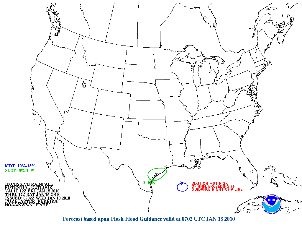
Interesting to note the HPC Excessive Rainfall Outlook has shift up the Coast into SE TX on day 3. The plot thickens...
...TEXAS/WRN GULF COAST...
SCT SHWR ACTIVITY IS EXPECTED TO GIVE WAY TO MORE WIDESPREAD PCPN
AS THE UPSTREAM HEIGHT FALLS DIGGING INTO NRN MEX FORGES A ROBUST
CLSD MID/UPR LVL LOW THAT APPROACHES THE REGION. THESE STRONGER
HEIGHT FALLS WILL YIELD ADDITIONAL SFC PRESSURE FALLS AND
ULTIMATELY THE DEVELOPMENT OF SFC LOW PRESSURE OFF THE TX COAST BY
EARLY FRI...AND AS A RESULT WILL ALLOW FOR A MUCH MORE SIGNIFICANT
WARM AIR/MOISTURE ADVECTION PATTERN TO SET-UP ALONG THE WRN GULF
COAST REGION. ELY H85 FLOW INCREASING TO AROUND 40 KTS OFF THE
GULF OF MEXICO AND INTO THE LWR TX COASTLINE...IN CONJUNCTION WITH
STG LOW LVL CONVERGENCE AND FORMIDABLE LEFT-EXIT REGION UPR JET
DYNAMICS/DIVERGENCE SHOULD ALLOW A WIDESPREAD AXIS OF MDT TO HVY
RAIN TO DEVELOP ALONG WITH STRONGER CONVECTIVE ELEMENTS. THE
HEAVIEST FOCUS OF RAIN LATE THU/FRI SHOULD BE ALONG AND JUST
INLAND FROM THE COAST...WITH A THREAT OF LOCALLY EXCESSIVE
RAINFALL AMTS. 00Z MODELS ARE IN FAIRLY GOOD AGREEMENT THE LARGE
SCALE FEATURES OF THIS SYSTEM...HOWEVER BY EARLY SAT THE FORECAST
BECOMES A LITTLE MORE COMPLICATED WHEN AS NOTED IN THE
PMDHMD...BOTH THE NAM AND GFS DEVELOP WHAT APPEARS TO BE
CONVECTIVELY-INDUCED OR ENHANCED MESOSCALE LOWS WHICH THEN ENHANCE
THE BAROCLINICITY ALONG A DEVELOPING STNRY FRONT EXTENDING THROUGH
NRN FL AS THEY LIFT AHEAD OF THE PARENT SYSTEM. DO NOT HAVE
ENOUGH CONFIDENCE IN ANY PARTICULAR MODEL THAT FAR OUT TO STRICTLY
FOLLOW ITS MESOSCALE DETAILS AND RESULTANT QPF AND INSTEAD
FOLLOWED AN APPROACH THAT FOCUSED THE STRONGEST ASCENT OVER THE
NWRN/N-CTRL GOMEX...KEEPING THE MORE SIGNIFICANT AMTS CONFINED TO
THE IMMEDIATE COAST LATE IN THE PERIOD WHILE DOWNPLAYING THE
HEAVIER AMTS OF THE GFS ACROSS NRN FL FOR THE MOMENT.
0 likes
Carla/Alicia/Jerry(In The Eye)/Michelle/Charley/Ivan/Dennis/Katrina/Rita/Wilma/Ike/Harvey
Member: National Weather Association
Wx Infinity Forums
http://wxinfinity.com/index.php
Facebook.com/WeatherInfinity
Twitter @WeatherInfinity
Member: National Weather Association
Wx Infinity Forums
http://wxinfinity.com/index.php
Facebook.com/WeatherInfinity
Twitter @WeatherInfinity


-
srainhoutx
- S2K Supporter
- Posts: 6919
- Age: 68
- Joined: Sun Jan 14, 2007 11:34 am
- Location: Haywood County, NC
- Contact:
Re:
txagwxman wrote:Amazing how this thread dies down when there is no signs of Arctic air.
I suspect that it will pick up later today. With the amount of rainfall expected in the Lone Star State we will likey see a lot of chatter again. I noticed S CA had some T Storms this morning with CG strikes being reported. A lot of dynamics with this storm. I have a busy day with some major upgrades about to happen within the next couple of hours, so I'll be 'out of pocket' for a while during the mid day time frame.
Last edited by srainhoutx on Wed Jan 13, 2010 10:29 am, edited 1 time in total.
0 likes
Carla/Alicia/Jerry(In The Eye)/Michelle/Charley/Ivan/Dennis/Katrina/Rita/Wilma/Ike/Harvey
Member: National Weather Association
Wx Infinity Forums
http://wxinfinity.com/index.php
Facebook.com/WeatherInfinity
Twitter @WeatherInfinity
Member: National Weather Association
Wx Infinity Forums
http://wxinfinity.com/index.php
Facebook.com/WeatherInfinity
Twitter @WeatherInfinity
-
Portastorm
- Storm2k Moderator
- Posts: 9955
- Age: 63
- Joined: Fri Jul 11, 2003 9:16 am
- Location: Round Rock, TX
- Contact:
Re:
txagwxman wrote:Amazing how this thread dies down when there is no signs of Arctic air.
Well what do you expect ... every time we try to spin up some snow or ice out of a system, you and your other professional meteorologist buddies just RAIN on our parade!
All kidding aside, like srainhoutx just said in his post, I bet we'll see some increase in traffic later today as this system gets going. While it likely will not provide winTRY weather, it is WINTER weather and could be notable weather and worth reporting and discussing!
I'm glad you're here txagwxman. We always appreciate your insight and posts!
0 likes
Re:
txagwxman wrote:Amazing how this thread dies down when there is no signs of Arctic air.
Well it is titled the 'Texas winter wx' thread =P if there's not wintry weather naturally less posts. Though yes rain and such in winter is also weather but we might as well make a rain\thunderstorms thread
0 likes
The above post and any post by Ntxw is NOT an official forecast and should not be used as such. It is just the opinion of the poster and may or may not be backed by sound meteorological data. It is NOT endorsed by any professional institution including Storm2k. For official information, please refer to NWS products.
Help support Storm2K!
Help support Storm2K!
Re: Re:
Portastorm wrote:txagwxman wrote:Amazing how this thread dies down when there is no signs of Arctic air.
Well what do you expect ... every time we try to spin up some snow or ice out of a system, you and your other professional meteorologist buddies just RAIN on our parade!
All kidding aside, like srainhoutx just said in his post, I bet we'll see some increase in traffic later today as this system gets going. While it likely will not provide winTRY weather, it is WINTER weather and could be notable weather and worth reporting and discussing!
I'm glad you're here txagwxman. We always appreciate your insight and posts!
TY---I am a severe weather nut too.
0 likes
“If you thought that science was certain - well, that is just an error on your part.”
-
srainhoutx
- S2K Supporter
- Posts: 6919
- Age: 68
- Joined: Sun Jan 14, 2007 11:34 am
- Location: Haywood County, NC
- Contact:
Re: Re:
txagwxman wrote:Portastorm wrote:txagwxman wrote:Amazing how this thread dies down when there is no signs of Arctic air.
Well what do you expect ... every time we try to spin up some snow or ice out of a system, you and your other professional meteorologist buddies just RAIN on our parade!
All kidding aside, like srainhoutx just said in his post, I bet we'll see some increase in traffic later today as this system gets going. While it likely will not provide winTRY weather, it is WINTER weather and could be notable weather and worth reporting and discussing!
I'm glad you're here txagwxman. We always appreciate your insight and posts!
TY---I am a severe weather nut too.
Ditto! Actually many of us are weather nuts period.
While the wintry weather may take a brief break, it does appear we are heading into a rather active pattern with a Very Strong Pacific Jet of +200kts hitting the W Coast for the next week or so. HPC Final Extended Disco suggests an active pattern as well...
EXTENDED FORECAST DISCUSSION
NWS HYDROMETEOROLOGICAL PREDICTION CENTER CAMP SPRINGS MD
136 PM EST WED JAN 13 2010
VALID 12Z SAT JAN 16 2010 - 12Z WED JAN 20 2010
...AN ACTIVE MEDIUM RANGE HEAVY RAINFALL PATTERN FOR CA/SW US AND
THE SERN US...
STRONG ZONAL FLOW CONTINUING ACROSS THE MID-LATITUDES OF THE
PACIFIC AND BENEATH A DEEP UPPER CYCLONE NEAR THE ALEUTIANS SHOULD
HELP PERPETUATE FREQUENT DEVELOPMENT AND/OR AMPLIFICATION OF
PERTURBATIONS EMBEDDED WITHIN THE FLOW ONCE THEY REACH THE WEST
COAST DURING THE MEDIUM RANGE PERIOD BEFORE SPLITTING...WITH
SOUTHERN PORTIONS OF THE SPLIT CONTAINING THE MOST ENERGY AND
PRODUCING THE GREATEST IMPACTS IN TERMS OF SENSIBLE WEATHER.
MODELS AND THEIR ENSEMBLES ARE IN GOOD AGREEMENT ON THIS PROCESS
OCCURRING...BUT CONTINUE TO DISPLAY CONSIDERABLE MODEL AND
RUN-TO-RUN VARIABILITY WITH THE DETAILS.
THE FIRST OF THESE SIGNIFICANT HEAVY PCPN FOCUSING SYSTEMS WILL BE
ONGOING AT THE START OF DAY 3/SAT AS A CLOSED LOW OVER
TEXAS...WITH THE GFS A LITTLE FASTER TO TRACK THE LOW ACROSS THE
GULF COAST/SOUTHEAST THAN THE ECMWF WHILE ALSO ALLOWING THE LOW TO
PHASE WITH ANOTHER SMALLER LOW TO ITS NORTH...WHICH THEN ASSISTS
IN FURTHER DEEPENING IN THE WESTERN ATLANTIC TUE/WED DAYS 6/7.
THIS PARTICULAR 00 UTC GFS EVOLUTION BY DAYS 6/7 APPEARS OVERDONE.
HOWEVER...ITS LOW PLACEMENT AND FASTER PROGRESSION OUT TO SEA SEEM
MORE REALISTIC THAN THE 00 UTC ECMWF GIVEN THE PROGRESSIVE PATTERN
UPSTREAM. THIS MORE PROGRESSIVE SOLUTION HAS MUCH BETTER SUPPORT
FROM GFS/CANADIAN/NAEFS AND EVEN ECMWF ENSEMBLES...AND NEWER
OVERALL GUIDANCE FROM 12 UTC INCLUDING THE NEWER ECMWF.
OTHERWISE...THE PRIMARY CHALLENGES RESIDE IN THE WEST WHERE A
REGULAR BARRAGE OF SIGNIFICANT SHORTWAVE TROUGHS WILL REACH THE US
WEST COAST BEFORE MOVING INLAND...AND WITHIN THE NORTHERN STREAM
ALONG THE U.S/CANADIAN BORDER WHERE GUIDANCE DISPLAYS CONSIDERABLE
PLACEMENT AND AMPLITUDE DIFFERENCES WITH TROUGHS CROSSING THE
CANADIAN ROCKIES. PREFER A BLEND SOMEWHERE BETWEEN THE
GFS/ECMWF...TO ADDRESS TIMING/STRENGTH DIFFERENCES INTO EARLY NEXT
WEEK BEFORE BLENDING IN CONSIDERABLE GFS ENSEMBLE MEAN GUIDANCE
AMID GROWING UNCERTAINTY. 12 UTC MODEL AND ENSEMBLE GUIDANCE ADDS
A FEW WRINKLES WITH DETAILS OF LESS PREDICTABLE EMBEDDED
SYSTEMS...BUT FORECASTER CONFIDENCE REMAINS ABOVE NORMAL WITH THE
LARGER SCALE PATTERN THAT SEEMS HIGHLY FAVORABLE FOR A PROLONGED
HEAVY PCPN EPISODE FOR MUCH OF CA AND THE SWRN STATES INLAND ALL
NEXT WEEK WITHIN A POTENT SRN STREAM FLOW.
OVERALL...FINAL HPC PRESSURES/FRONTS PROGS MAINTAIN CLOSE
CONTINUITY AND REMAIN PRIMARILY DERIVED FROM A 50-50 BLEND OF THE
00 UTC GFS/ECMWF THIS WEEKEND...ALBIET WITH A FEW MANUAL
ADJUSTMENTS...BEFORE TRANSITIONING TO A 50-50 GFS/GEFS MEAN BY
TUE/WED...MAINLY TO BACK-AWAY FROM THE ECMWF IN THE WESTERN
ATLANTIC IN FAVOR OF A MORE PROGRESSION SCENARIO.
JAMES/SCHICHTEL
0 likes
Carla/Alicia/Jerry(In The Eye)/Michelle/Charley/Ivan/Dennis/Katrina/Rita/Wilma/Ike/Harvey
Member: National Weather Association
Wx Infinity Forums
http://wxinfinity.com/index.php
Facebook.com/WeatherInfinity
Twitter @WeatherInfinity
Member: National Weather Association
Wx Infinity Forums
http://wxinfinity.com/index.php
Facebook.com/WeatherInfinity
Twitter @WeatherInfinity
-
Portastorm
- Storm2k Moderator
- Posts: 9955
- Age: 63
- Joined: Fri Jul 11, 2003 9:16 am
- Location: Round Rock, TX
- Contact:
Re: Texas winter wx thread (2009-2010)
... and the 12z GFS suggests a return to winter weather temperatures and precip after about 300 hours! 
0 likes
-
srainhoutx
- S2K Supporter
- Posts: 6919
- Age: 68
- Joined: Sun Jan 14, 2007 11:34 am
- Location: Haywood County, NC
- Contact:
Re: Texas winter wx thread (2009-2010)
0 likes
Carla/Alicia/Jerry(In The Eye)/Michelle/Charley/Ivan/Dennis/Katrina/Rita/Wilma/Ike/Harvey
Member: National Weather Association
Wx Infinity Forums
http://wxinfinity.com/index.php
Facebook.com/WeatherInfinity
Twitter @WeatherInfinity
Member: National Weather Association
Wx Infinity Forums
http://wxinfinity.com/index.php
Facebook.com/WeatherInfinity
Twitter @WeatherInfinity
0 likes
The above post and any post by Ntxw is NOT an official forecast and should not be used as such. It is just the opinion of the poster and may or may not be backed by sound meteorological data. It is NOT endorsed by any professional institution including Storm2k. For official information, please refer to NWS products.
Help support Storm2K!
Help support Storm2K!
-
Portastorm
- Storm2k Moderator
- Posts: 9955
- Age: 63
- Joined: Fri Jul 11, 2003 9:16 am
- Location: Round Rock, TX
- Contact:
Re: Texas winter wx thread (2009-2010)
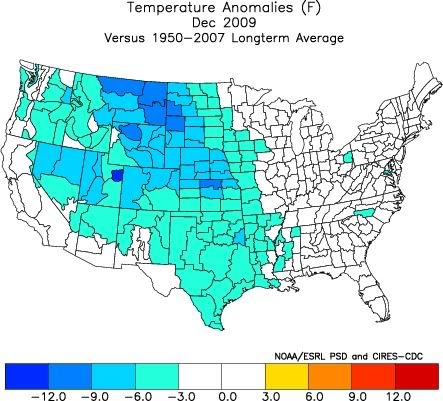
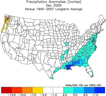
Well, temperature and precip-wise, here is how December 2009 compared to the average years between 1950-2007:
TEMPERATURE
PRECIPITATION
TEMPERATURE
PRECIPITATION
0 likes
Shows how unique this winter has been. I'm sure most including the CPC had the northern plains\rockies above average with the el nino
0 likes
The above post and any post by Ntxw is NOT an official forecast and should not be used as such. It is just the opinion of the poster and may or may not be backed by sound meteorological data. It is NOT endorsed by any professional institution including Storm2k. For official information, please refer to NWS products.
Help support Storm2K!
Help support Storm2K!
-
srainhoutx
- S2K Supporter
- Posts: 6919
- Age: 68
- Joined: Sun Jan 14, 2007 11:34 am
- Location: Haywood County, NC
- Contact:
Re: Texas winter wx thread (2009-2010)
While we will not see wintry weather with the current system and a January thaw looks in order, we do have some active TX El Nino Winter Weather to be concerned with. While we usually keep our discussions in the US Weather Area, I think it is noteworthy and prudent to continue the discussion here as we will likely be looking for a return to a much colder pattern following next week and just beyond. With that said, things certainly look interesting for the Southern half of TX with this very dynamic setup. Austin AFD is concerning...
AREA FORECAST DISCUSSION
NATIONAL WEATHER SERVICE AUSTIN/SAN ANTONIO TX
422 AM CST THU JAN 14 2010
.DISCUSSION...
AN ANOMALOUS JANUARY HEAVY RAIN EVENT IS FORECAST TO BEGIN LATER
TODAY AS THE UPPER LOW OVER SOUTHERN ARIZONA APPROACHES. THIS IS A
HIGH CONFIDENCE FORECAST...BOTH IN THE OCCURRENCE OF RAIN AND
STORM TOTAL AMOUNTS. ALTHOUGH THE 00Z GFS AND ECMWF SOLUTIONS
DIFFER IN FORECAST AMOUNTS...BOTH MODELS DEPICT THE AXIS OF
GREATEST QPF EXTENDING FROM NEAR CORPUS CHRISTI NNW TO BETWEEN SAN
ANTONIO AND NEW BRAUNFELS...THEN NORTH TO NEAR BURNET. 3 TO 5
INCHES CAN BE EXPECTED ALONG AND 30 MILES TO EITHER SIDE OF THAT
LINE...WITH SPOTTY TOTALS UP TO 6 INCHES. LESSER AMOUNTS CAN BE
EXPECTED TO EITHER SIDE OF THAT AREA...GENERALLY BETWEEN 1 AND 3
INCHES. MOST OF THAT RAIN WILL FALL DURING A 24H PERIOD BETWEEN
6PM TODAY AND 6PM FRIDAY. SURFACE BASED INSTABILITIES WILL BE ON
THE INCREASE TODAY AND ISOLATED THUNDERSTORMS ARE FORECAST ACROSS
OUR EASTERN HALF BY AFTERNOON. THUNDERSTORMS WILL INCREASE IN
COVERAGE TONIGHT...BUT DECREASE IN COVERAGE LATER FRIDAY AS THE
UPPER LOW MOVES SOUTH OF THE AREA AND CONVECTION BECOMES MORE
SHALLOW. A FLASH FLOOD WATCH WILL LIKELY BE REQUIRED AND ISSUED
LATER TODAY FOR TONIGHT INTO FRIDAY. RAIN WILL END ON SATURDAY AS
THE UPPER LOW PULLS OFF TO THE EAST. RIDGING BEHIND THE
LOW...COMBINED WITH WET SURFACES...CLEARING SKIES AND LIGHT WINDS
WILL SET THE STAGE FOR FOG DEVELOPMENT LATE SATURDAY NIGHT INTO
SUNDAY...THEN AGAIN SUNDAY NIGHT INTO MONDAY MORNING. A ZONAL FLOW
WILL DEVELOP ACROSS THE SOUTHERN-MOST CONUS LATE MONDAY AND
CONTINUE INTO TUESDAY. A SHORTWAVE TROUGH IS FORECAST TO PROGRESS
EAST ACROSS THE SOUTHERN ROCKIES ON WEDNESDAY AND PUSH A DRY
PACIFIC FRONT THROUGH OUR AREA ON THURSDAY. A WARMING TREND IS
FORECAST NEXT WEEK AHEAD OF THIS FEATURE...WITH HIGHS WELL ABOVE
NORMAL.
HPC QPF Discussion this morning...
...TX...
THE LATEST MDL SOLNS ARE IN VRY GOOD AGREEMENT IN THEIR HANDLING
OF THE STRENGTHENING MID/UPR LVL CLOSED LOW NOW OVR THE SWRN
STATES..WITH ALL DRIVING IT SSEWD INTO NRN OLD MEX BY THE END OF
THE PD. GIVEN THE OBSERVED 150+KT H250 JET DIGGING DOWN THRU SRN
CA/NRN BAJA ATTM..THIS SSEWD MOVEMENT AND STRENGTHENING OF THE SYS
SEEMS QUITE ACCEPTABLE. AHD OF THIS SYS..THE MID/UPR LVL FLO WL
BACK CONSIDERABLY OVR THE SRN PLAINS AND SLY-SSELY LOW LVL FLO OFF
THE WRN GULF WL INCREASE INTO CNTRL AND SRN TX..ALL OF WHICH WL
LEAD TO AN INCREASE IN OVRRNG RAINS ESP OVR TX. LRG SCALE LIFT
SHLD BE ENHANCED BY AN INCREASINGLY DIFL UPR FLO REGIME DVPLG LTR
IN THE PD. HAVE MODELLED THE HVIER RAINS TO WHERE THE MORE
PRONOUNCED INVERTED SFC TROF WL SET UP IN TX..AND WHERE THE STGR
LOW LVL INFLO AND HIER PWS INTERACT WITH THIS INVERTED SFC
TROF..MAINLY FM THE SRN AND CNTRL PTNS OF THE TX CST NWD INTO
CNTRL TX. GFS MAY BE SUFFERING A LTL FM FEEDBACK PROBS THU NGT
AND THUS ITS QPF MAY BE A LTL TOO HVY..WHILE THE NAM QPF AS USUAL
LOOKS A LTL UNDERDONE..SO MANUAL QPF WAS LGTR THAN THE GFS..HVIER
THAN THE NAM AND CLOSER TO THE GFS QPF AXIS..WITH SOME MAX RNFL
AMTS OF 2-3+ INCHES QUITE LIKELY.
Enjoy the January Thaw while it lasts.
0 likes
Carla/Alicia/Jerry(In The Eye)/Michelle/Charley/Ivan/Dennis/Katrina/Rita/Wilma/Ike/Harvey
Member: National Weather Association
Wx Infinity Forums
http://wxinfinity.com/index.php
Facebook.com/WeatherInfinity
Twitter @WeatherInfinity
Member: National Weather Association
Wx Infinity Forums
http://wxinfinity.com/index.php
Facebook.com/WeatherInfinity
Twitter @WeatherInfinity
-
Portastorm
- Storm2k Moderator
- Posts: 9955
- Age: 63
- Joined: Fri Jul 11, 2003 9:16 am
- Location: Round Rock, TX
- Contact:
Re: Texas winter wx thread (2009-2010)
Yep srainhoutx, looks like my area of the state is "under the gun" with this system.
Three to five inches of rain in 24 hours from a January system is fairly rare in these parts!
Three to five inches of rain in 24 hours from a January system is fairly rare in these parts!
0 likes
Who is online
Users browsing this forum: No registered users and 135 guests