Southern Plains winter wx thread (2009-2010)
Moderator: S2k Moderators
Forum rules
 The posts in this forum are NOT official forecast and should not be used as such. They are just the opinion of the poster and may or may not be backed by sound meteorological data. They are NOT endorsed by any professional institution or STORM2K.

The posts in this forum are NOT official forecast and should not be used as such. They are just the opinion of the poster and may or may not be backed by sound meteorological data. They are NOT endorsed by any professional institution or STORM2K.
-
Extremeweatherguy

- Category 5

- Posts: 11095
- Joined: Mon Oct 10, 2005 8:13 pm
- Location: Florida
-
srainhoutx

- S2K Supporter

- Posts: 6919
- Age: 68
- Joined: Sun Jan 14, 2007 11:34 am
- Location: Haywood County, NC
- Contact:
Re:
Extremeweatherguy wrote:I have a glaze of ice starting to develop outside now.
Looks like a long duration event EWG. The storm has no real kicker yet so stay safe and be careful.
0 likes
Carla/Alicia/Jerry(In The Eye)/Michelle/Charley/Ivan/Dennis/Katrina/Rita/Wilma/Ike/Harvey
Member: National Weather Association
Wx Infinity Forums
http://wxinfinity.com/index.php
Facebook.com/WeatherInfinity
Twitter @WeatherInfinity
Member: National Weather Association
Wx Infinity Forums
http://wxinfinity.com/index.php
Facebook.com/WeatherInfinity
Twitter @WeatherInfinity
-
msstateguy83
Re: Southern Plains winter wx thread (2009-2010)
i just heard per koco out of okc reports of ice even forming as far south as the noble area now which is just south of norman about 10-15 mins... so ice is becoming a prob very quickly up there
0 likes
-
msstateguy83
srainhoutx what do you think about w.falls area? you think oun will be right temps hover above frzing or keep droping here? i have been falling quite steady 35 @ a weatherbug site in town now 33 @ my house... i have a feeling they might just move that wsw more southward later per the temps dropping fast....
0 likes
-
Weatherdude20
Re: Southern Plains winter wx thread (2009-2010)
Ice forming on E1190 Road on the west side of 183 near Cordell.
0 likes
-
srainhoutx
- S2K Supporter
- Posts: 6919
- Age: 68
- Joined: Sun Jan 14, 2007 11:34 am
- Location: Haywood County, NC
- Contact:
Re:
msstateguy83 wrote:srainhoutx what do you think about w.falls area? you think oun will be right temps hover above frzing or keep droping here? i have been falling quite steady 35 @ a weatherbug site in town now 33 @ my house... i have a feeling they might just move that wsw more southward later per the temps dropping fast....
Going to be close in the Falls area. Warm inflow just above the surface will help keep things liquid right now IMHO.
0 likes
Carla/Alicia/Jerry(In The Eye)/Michelle/Charley/Ivan/Dennis/Katrina/Rita/Wilma/Ike/Harvey
Member: National Weather Association
Wx Infinity Forums
http://wxinfinity.com/index.php
Facebook.com/WeatherInfinity
Twitter @WeatherInfinity
Member: National Weather Association
Wx Infinity Forums
http://wxinfinity.com/index.php
Facebook.com/WeatherInfinity
Twitter @WeatherInfinity
Re: Southern Plains winter wx thread (2009-2010)
as of 745am there was ice forming on the south side of okc near moore area. we have an electric gate but have the chain removed due to the weather and i could barely get theg ate open due to ice forming on it already.
0 likes
-
msstateguy83
Re: Southern Plains winter wx thread (2009-2010)
heavy ice starting to pile up in sw ok in greer county, i have heard reports & just got one myself and i dont know if
it goes along with the ice or what i suspect so but about 5 mesonet sites are not reporting could it be the sensors
lost power??
it goes along with the ice or what i suspect so but about 5 mesonet sites are not reporting could it be the sensors
lost power??
0 likes
-
BlueIce
- S2K Supporter
- Posts: 194
- Age: 37
- Joined: Mon Sep 01, 2008 10:05 pm
- Location: Oklahoma City, Oklahoma
Re: Southern Plains winter wx thread (2009-2010)
Now down to 28 here on the east side, Ice is forming on all elevated surfaces, Precip looks to be expanding for the metro area. Local reports are now confirming the report from MsState, Ice is stopping the measuring equipment currently
0 likes
-
msstateguy83
-
msstateguy83
i have not had time to look in detail but it appears with the system moving so slow we could be looking at a frz rain event over ok into nw tx till almost midnight tonight before a change over to snow.. that is subject to change BUT attm with the slow progression of this system it appears a very prolonged event of frz rain.
0 likes
-
Extremeweatherguy
- Category 5
- Posts: 11095
- Joined: Mon Oct 10, 2005 8:13 pm
- Location: Florida
-
msstateguy83
Re: Southern Plains winter wx thread (2009-2010)
iam gonna check out upper level temps in just a few on the latest data see how it looks.. just need to pray the column can
cool quickly enough that we atleast transition to ip, the sooner the better otherwise this could be one big disastrous ice storm
in the making.
cool quickly enough that we atleast transition to ip, the sooner the better otherwise this could be one big disastrous ice storm
in the making.
0 likes
-
msstateguy83
-
random_in_okc
- Tropical Wave

- Posts: 3
- Joined: Thu Jan 28, 2010 9:39 am
Re: Southern Plains winter wx thread (2009-2010)
currently ice is falling in SW okc near airport.
0 likes
-
wxman57

- Moderator-Pro Met

- Posts: 23170
- Age: 68
- Joined: Sat Jun 21, 2003 8:06 pm
- Location: Houston, TX (southwest)
Re:
msstateguy83 wrote:srainhoutx what do you think about w.falls area? you think oun will be right temps hover above frzing or keep droping here? i have been falling quite steady 35 @ a weatherbug site in town now 33 @ my house... i have a feeling they might just move that wsw more southward later per the temps dropping fast....
I took a look at the latest RUC soundings for Wichita Falls. The model indicates slow cooling at the surface, down to near freezing by 6pm. Note the VERY warm air just above the surface today. The profile indicates cold rain, with some freezing rain on elevated surfaces. But surface temps should be up enough to prevent significant accumulations on roadways. Bridges could have an issue this evening:
Wichita falls 12Z RUC Sounding:

Sounding forecast for 18Z

Sounding forecast for 00Z

0 likes
-
BlueIce
- S2K Supporter
- Posts: 194
- Age: 37
- Joined: Mon Sep 01, 2008 10:05 pm
- Location: Oklahoma City, Oklahoma
Re: Southern Plains winter wx thread (2009-2010)
Check out the MCS that may be moving towards Oklahoma. Talk about heavy precip.


0 likes
-
srainhoutx
- S2K Supporter
- Posts: 6919
- Age: 68
- Joined: Sun Jan 14, 2007 11:34 am
- Location: Haywood County, NC
- Contact:
Re: Southern Plains winter wx thread (2009-2010)
Just FYI: Centerpoint Energy is enroute from Houston with a convoy to assit those in OK.
0 likes
Carla/Alicia/Jerry(In The Eye)/Michelle/Charley/Ivan/Dennis/Katrina/Rita/Wilma/Ike/Harvey
Member: National Weather Association
Wx Infinity Forums
http://wxinfinity.com/index.php
Facebook.com/WeatherInfinity
Twitter @WeatherInfinity
Member: National Weather Association
Wx Infinity Forums
http://wxinfinity.com/index.php
Facebook.com/WeatherInfinity
Twitter @WeatherInfinity
-
Extremeweatherguy
- Category 5
- Posts: 11095
- Joined: Mon Oct 10, 2005 8:13 pm
- Location: Florida
Here is my latest idea on possible ice accumulations across the area..
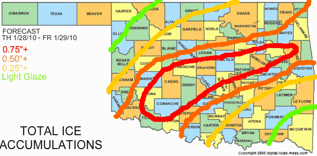
This assumes that freezing rain remains the main precipitation type for central Oklahoma through the first half of the afternoon. If that does indeed happen, which is looking more likely, then the large area of 0.75"+ icing totals seems quite likely, with some locations likely topping 1".
And here is my latest idea on possible snow/sleet accumulations..
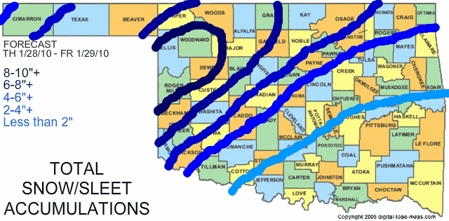
UPDATE >> There are now indications that we might try to changeover to sleet in a few areas more quickly than first thought. If this occurs, then I will need to reduce freezing rain amounts and increase sleet/snow amounts in a few areas, particularly from OKC westward. Stay tuned!
UPDATE #2 >> Latest models hint at the potential for more snow tomorrow in central Oklahoma. If this trend continues, then it is likely that I would need to expand and shift some of the higher snow totals toward the south and east.
This assumes that freezing rain remains the main precipitation type for central Oklahoma through the first half of the afternoon. If that does indeed happen, which is looking more likely, then the large area of 0.75"+ icing totals seems quite likely, with some locations likely topping 1".
And here is my latest idea on possible snow/sleet accumulations..
The following post is NOT an official forecast and should not be used as such. It is just the opinion of the poster and may or may not be backed by sound meteorological data. It is NOT endorsed by any professional institution including storm2k.org. For official information, please refer to NWS products.
UPDATE >> There are now indications that we might try to changeover to sleet in a few areas more quickly than first thought. If this occurs, then I will need to reduce freezing rain amounts and increase sleet/snow amounts in a few areas, particularly from OKC westward. Stay tuned!
UPDATE #2 >> Latest models hint at the potential for more snow tomorrow in central Oklahoma. If this trend continues, then it is likely that I would need to expand and shift some of the higher snow totals toward the south and east.
Last edited by Extremeweatherguy on Thu Jan 28, 2010 11:34 am, edited 3 times in total.
0 likes
Who is online
Users browsing this forum: BigB0882, Cpv17, Stratton23 and 75 guests