Texas Winter 2025-2026
Moderator: S2k Moderators
Forum rules
 The posts in this forum are NOT official forecast and should not be used as such. They are just the opinion of the poster and may or may not be backed by sound meteorological data. They are NOT endorsed by any professional institution or STORM2K.

The posts in this forum are NOT official forecast and should not be used as such. They are just the opinion of the poster and may or may not be backed by sound meteorological data. They are NOT endorsed by any professional institution or STORM2K.
-
South Texas Storms

- Professional-Met

- Posts: 4256
- Joined: Thu Jun 24, 2010 12:28 am
- Location: Houston, TX
Re: Texas Winter 2025-2026
Good post from the NWS in DFW on why it's mostly sleet up there now: https://x.com/NWSFortWorth/status/2015057720202649924
4 likes
-
Brandon8181
- S2K Supporter

- Posts: 431
- Age: 42
- Joined: Tue Jan 04, 2011 4:52 pm
- Location: Tyler, TX
- Contact:
Re: Texas Winter 2025-2026
iorange55 wrote:Prepare as we enter the, “that was it?” phase of this storm.
Let me help you with that….
Is this it? We were forecasted to get to 23 for an overnight low as of 8 am in South Tyler it’s holding firm at 32.
Very light glazing of ice/sleet on roof tops.
0 likes
I am not a meteorologist. Any post from me should be taken as hobby or fun educational information, but not an accurate source for weather information. Please, refer to your local weather station or National Weather Service for the most up to date information. 
-
CaptinCrunch

- S2K Supporter
- Posts: 8778
- Age: 58
- Joined: Mon Nov 03, 2003 4:33 pm
- Location: Kennedale, TX (Tarrant Co.)
Re: Texas Winter 2025-2026
Here in Mansfield it's a sleet/snow mix both of which are small pellets and flakes, and the streets are fully covered over.
3 likes
-
rwfromkansas
- Category 5

- Posts: 3029
- Joined: Sat Aug 27, 2005 12:47 am
- Location: North Fort Worth
Re: Texas Winter 2025-2026
Looks like I am in the screw zone currently. A few more rounds just north and south of me.
Hopefully get a bit more developing but this may be it for round one. At least ground covered but not the inch others have.
Hopefully get a bit more developing but this may be it for round one. At least ground covered but not the inch others have.
0 likes
-
orangeblood
- S2K Supporter
- Posts: 3895
- Joined: Tue Dec 15, 2009 6:14 pm
- Location: Fort Worth, TX
Re: Texas Winter 2025-2026
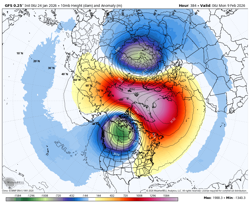
Winter is just getting started, textbook wave 2 pattern and a strat PV split to start February
10 likes
-
wxman22

- Category 5
- Posts: 1906
- Joined: Mon Jan 30, 2006 12:39 am
- Location: Wichita Falls, TX
- Contact:
Re: Texas Winter 2025-2026
It’s currently 11 here in WF  It’s absolutely beautiful outside! Moderate to heavy precip is also on its way here per radar.


It’s absolutely beautiful outside! Moderate to heavy precip is also on its way here per radar.
Last edited by wxman22 on Sat Jan 24, 2026 8:58 am, edited 2 times in total.
7 likes
-
Brent
- S2K Supporter
- Posts: 38730
- Age: 37
- Joined: Sun May 16, 2004 10:30 pm
- Location: Tulsa Oklahoma
- Contact:
Re: Texas Winter 2025-2026
iorange55 wrote:Prepare as we enter the, “that was it?” phase of this storm.
Oh we're way past that up here haha. It's been a bust from the start per some people. It got a late start and was never truly impressive
TV mets flat out admitting they were wrong
There was so much hype
Last edited by Brent on Sat Jan 24, 2026 8:59 am, edited 3 times in total.
0 likes
#neversummer

Re: Texas Winter 2025-2026
iorange55 wrote:Prepare as we enter the, “that was it?” phase of this storm.
Yep. So far in southern Denton County this is a big nothing burger so far. I was expecting a lot more. We did get .38 of rain yesterday, which was the first measurable rain we’ve had since November, so I guess it’s not all bad.
2 likes
-
ColdFusion

- S2K Supporter
- Posts: 452
- Joined: Wed Feb 13, 2008 3:46 pm
- Location: Addison, TX
Re: Texas Winter 2025-2026
I think I don’t really understand the concept of 100% chance of something happening when it comes to weather. Why not say 90% chance and save yourself room for the , very often , busts? Not trying to sound snarky at all, I know it sounds that way, but when I personally see 100% chance, to me that means absolute certainty, with zero chance of other outcomes.
3 likes
-
Ralph's Weather
- S2K Supporter
- Posts: 3371
- Age: 38
- Joined: Fri Dec 13, 2013 11:55 am
- Location: Lindale, TX
- Contact:
Re: Texas Winter 2025-2026
Brandon8181 wrote:iorange55 wrote:Prepare as we enter the, “that was it?” phase of this storm.
Let me help you with that….
Is this it? We were forecasted to get to 23 for an overnight low as of 8 am in South Tyler it’s holding firm at 32.
Very light glazing of ice/sleet on roof tops.
Round 1 was supposed to be mainly freezing rain so don't be sad to miss it. Up. In Lindale we have 1" of sleet with it falling moderately. Round 2 will be heavy sleet even further south vs round 1. Some around here could see some very heavy sleet accumulations tonight.
3 likes
Follow on Facebook at Ralph's Weather.

Re: Texas Winter 2025-2026
Kirby68 wrote:iorange55 wrote:Prepare as we enter the, “that was it?” phase of this storm.
Yep. So far in southern Denton County this is a big nothing burger so far. I was expecting a lot more. We did get .38 of rain yesterday, which was the first measurable rain we’ve had since November, so I guess it’s not all bad.
As the cast of Hamilton might say, “Just you wait, just you wait”
4 likes

Re: Texas Winter 2025-2026
Kirby68 wrote:iorange55 wrote:Prepare as we enter the, “that was it?” phase of this storm.
Yep. So far in southern Denton County this is a big nothing burger so far. I was expecting a lot more. We did get .38 of rain yesterday, which was the first measurable rain we’ve had since November, so I guess it’s not all bad.
Isnt this just round 1?
We have almost 24 hours left to go. Look at the radar returns all the back to El Paso and northern Mexico. This event is far from over
Currently heavy sleet here in Frisco
Side note, talked to my dad that lives just SE of Memphis, TN and they’re getting one hell of an ice storm
Last edited by R2C89 on Sat Jan 24, 2026 9:09 am, edited 1 time in total.
3 likes


Re: Texas Winter 2025-2026
ColdFusion wrote:I think I don’t really understand the concept of 100% chance of something happening when it comes to weather. Why not say 90% chance and save yourself room for the , very often , busts? Not trying to sound snarky at all, I know it sounds that way, but when I personally see 100% chance, to me that means absolute certainty, with zero chance of other outcomes.
If you got 1 sleet pellet or rain drop that is 100% something fell. A forecast of percentages does not tell you how much falls.
We tend to correlate confidence in coverage vs amounts, which isn't what they are doing.
6 likes
The above post and any post by Ntxw is NOT an official forecast and should not be used as such. It is just the opinion of the poster and may or may not be backed by sound meteorological data. It is NOT endorsed by any professional institution including Storm2k. For official information, please refer to NWS products.
Help support Storm2K!
-
Captmorg70
- Tropical Storm

- Posts: 206
- Age: 38
- Joined: Mon Dec 18, 2017 12:07 am
- Location: Highland Village Tx
Re: Texas Winter 2025-2026
ColdFusion wrote:I think I don’t really understand the concept of 100% chance of something happening when it comes to weather. Why not say 90% chance and save yourself room for the , very often , busts? Not trying to sound snarky at all, I know it sounds that way, but when I personally see 100% chance, to me that means absolute certainty, with zero chance of other outcomes.
I think it comes down to how weather forecasts work. They are made on the macro level. The whole forecast area or large blocks of it.
While we see the micro level our backyard and neighborhood.
So it might not happen 100% in your backyard. But it will happen 100% somewhere in your forecast area.
For Addison, that forecast area could be a pretty decent size.
0 likes
Location - Highland Village

Re: Texas Winter 2025-2026
South Texas Storms wrote:Good post from the NWS in DFW on why it's mostly sleet up there now: https://x.com/NWSFortWorth/status/2015057720202649924
From reading through all the posts here it seems like the frozen precip that has fallen has been more sleet and less freezing rain than most of the models depicted. Good thing if that trend continues.
8 likes
Any forecast I make is based on my opinion only. Please refer to the NWS or NHC for official forecasts.
Re: Texas Winter 2025-2026
Very fine snowflakes are mixing in with the sleet in Longview. 28F.
2 likes
-
Ralph's Weather
- S2K Supporter
- Posts: 3371
- Age: 38
- Joined: Fri Dec 13, 2013 11:55 am
- Location: Lindale, TX
- Contact:
Re: Texas Winter 2025-2026
Snowman67 wrote:South Texas Storms wrote:Good post from the NWS in DFW on why it's mostly sleet up there now: https://x.com/NWSFortWorth/status/2015057720202649924
From reading through all the posts here it seems like the frozen precip that has fallen has been more sleet and less freezing rain than most of the models depicted. Good thing if that trend continues.
We have been very lucky with round 1 that the warm nose was not as prominent as modeled. Round 2 will be heavy sleet for for I-20 corridor and north. South of that from Central Texas to Deep East Texas will be the heavy freezing rain band.
2 likes
Follow on Facebook at Ralph's Weather.
-
orangeblood
- S2K Supporter
- Posts: 3895
- Joined: Tue Dec 15, 2009 6:14 pm
- Location: Fort Worth, TX
Re: Texas Winter 2025-2026
Captmorg70 wrote:ColdFusion wrote:I think I don’t really understand the concept of 100% chance of something happening when it comes to weather. Why not say 90% chance and save yourself room for the , very often , busts? Not trying to sound snarky at all, I know it sounds that way, but when I personally see 100% chance, to me that means absolute certainty, with zero chance of other outcomes.
I think it comes down to how weather forecasts work. They are made on the macro level. The whole forecast area or large blocks of it.
While we see the micro level our backyard and neighborhood.
So it might not happen 100% in your backyard. But it will happen 100% somewhere in your forecast area.
For Addison, that forecast area could be a pretty decent size.
Also why the NWS office forecasted a wide range of 1-5" amounts across North Texas. Almost impossible to pin point exact amounts at each location.
5 likes
-
gboudx

- S2K Supporter
- Posts: 4090
- Joined: Thu Sep 04, 2003 1:39 pm
- Location: Rockwall, Tx but from Harvey, La
Re: Texas Winter 2025-2026
From jeff:
Winter Storm Update (Sat AM)
Significant Witner Storm to impact the state and region over the next 24-36 hours.
Significant travel impacts are likely across the region and state.
Dangerous and damaging cold likely Monday and Tuesday mornings
Preparations for this cold weather event should be completed.
Timing:
Freezing line is advancing through Texas this morning and currently extends from Dallas to just northwest of San Antonio. Northwest of this line freezing rain and sleet are covering a large portion of NW/W/ and N TX and this mixed precipitation will move southward through the day. Freezing line may be running a little but faster than expected, but not enough to change any of the timing. Freezing line is likely to reach the College Station to Huntsville area mid to late afternoon and a Columbus to Conroe line by early evening then down to the US 59 corridor late evening and on to the coast early Sunday.
Temperatures:
Potentially damaging hard freezes are likely Mon and Tues AM
Many hours at or below freezing is expected across much of the region which will worsen the impacts of the extremely cold temperatures
Once the area falls below freezing Saturday evening a prolonged period of sub-freezing temperatures is likely with durations potentially exceeding 30-48 hours over the metro area and 60-72 hours north of HWY 105. It is increasingly likely many areas will not rise above freezing on Sunday and only briefly on Monday.
Wind chills will fall to dangerous levels Sunday into Monday with values below 0 north and west of the metro area and 1’s elsewhere…do NOT underestimate this cold.
North of HWY 105:
Sun AM: 21-24
Mon AM: 13-16
Tues AM: 14-16
North of I-10
Sun AM: 25-31
Mon AM: 14-21
Tues AM: 14-21
South of I-10:
Sun AM: 27-32
Mon AM: 18-22
Tues AM: 17-22
Precipitation:
Freezing rain remains likely especially north and west of the metro area Saturday night and advancing toward the US-59 corridor and to the coast on Sunday
Ice accumulation is likely across much of the area with the highest amounts to the north and west.
Travel impacts are likely on elevated bridges, overpasses, flyovers, and connector ramps late Saturday into Sunday and lingering into Monday.
Ongoing showers and thunderstorms this morning with heavy rainfall will move east of the area over the next few hours. Scattered light rain and showers will continue into the afternoon hours. Another round of showers and thunderstorms will develop across the area later tonight into early Sunday. As the freezing line advances southward tonight into Sunday morning a transition to freezing rain is likely for much of the area along with accumulations of ice.
Accumulations:
Storm event accumulations range from .05 to .25 of an inch from the US 59/I-10 corridor northward with the highest amounts found north of HWY 105 where a longer overlap of freezing temperatures and precipitation is most likely. South of I-10 amounts could range in the .01 to .05 range. While these amounts may seem low, it only takes a very small amount of ice to create extremely hazardous driving conditions on bridges and overpasses.
.25 of an inch of ice is generally when power outages and tree damage begin to occur. Dmaage to trees and power lines is likely in the Ice Storm Warning area where accumulations of .30-.50 will be possible.
Potential Ice Accumulations:
North of HWY 105: .25-.40
North of I-10/US 59: .05-.20
South of I-10/US 59: .01-.05
Additionally, gusty winds of 15-25mph will add stress to ice covered tree limbs and powerlines.
Preparations:
Proper winterization of any exposed pipes/plumbing MUST occur to prevent infrastructure damage. Sprinkler systems must be shut off and properly drained. Exterior facing wall pipes will be a risk of freezing at the forecasted temperatures.
Pets/livestock will require proper shelter to protect from the cold temperatures and wind chills. Unprotected pets and livestock risk hypothermia and death. Additionally, water sources are likely to freeze over.
Tropical plants/vegetation will require maximum freeze protection. Unprotected tropical vegetation will be killed and even protect vegetation will likely suffer extensive damage.
Persons should limit outdoor exposure during the cold. Utilize heating sources properly to reduce the risk of fire and carbon monoxide poisoning.
1 likes
Who is online
Users browsing this forum: No registered users and 49 guests