Texas winter wx thread (2009-2010)
Moderator: S2k Moderators
Forum rules
 The posts in this forum are NOT official forecast and should not be used as such. They are just the opinion of the poster and may or may not be backed by sound meteorological data. They are NOT endorsed by any professional institution or STORM2K.

The posts in this forum are NOT official forecast and should not be used as such. They are just the opinion of the poster and may or may not be backed by sound meteorological data. They are NOT endorsed by any professional institution or STORM2K.
-
serenata09
- Tropical Storm

- Posts: 166
- Joined: Fri Jan 18, 2008 7:55 pm
- Location: Dallas, TX


Re: Texas winter wx thread (2009-2010)
Should be interesting. If there are thunderstorms on Thursday to Friday morning, it would be the first since Christmas Eve 2009. I notice night time storms are more common in the winter and spring, than rarely in the summer, than picks up again in the fall. Probably has to do with the fronts coming. Night time storms in the summer are usually from unusually active sea breeze storms, warm core low pressure, or tropical systems. Same can apply to fall. Spring and winter is due to cold fronts.
0 likes


-
wall_cloud

- Professional-Met

- Posts: 401
- Age: 49
- Joined: Sun Dec 04, 2005 7:32 am
- Location: Bartlett, TN
- Contact:
Re: Texas winter wx thread (2009-2010)
rainman31 wrote:Sure is quiet in here tonight.
too many depressed north Texas folks.
0 likes
My comments are my own and do not reflect those of NOAA or the National Weather Service.


0 likes
The above post and any post by Ntxw is NOT an official forecast and should not be used as such. It is just the opinion of the poster and may or may not be backed by sound meteorological data. It is NOT endorsed by any professional institution including Storm2k. For official information, please refer to NWS products.
Help support Storm2K!
Re: Texas winter wx thread (2009-2010)
I guess so. Just took a look in the panhandle and it's already freezing in some areas, Dalhart is at 32 and Amarillo is at 34.
0 likes
Gonna be one heck of a storm up there. I've noticed Amarillo (relative to what they could be seeing) hasn't been in much of the action this year as in most years they are the center point of snow for Texas. This storm should easily fix that though the blizzard conditions looks nasty.
0 likes
The above post and any post by Ntxw is NOT an official forecast and should not be used as such. It is just the opinion of the poster and may or may not be backed by sound meteorological data. It is NOT endorsed by any professional institution including Storm2k. For official information, please refer to NWS products.
Help support Storm2K!
Help support Storm2K!
-
msstateguy83
not trying to say told you so but as i stated earlyer front blasting past oklahoma @ this hour all forecasts from oun to fws might have to be changed in the coming hours to acct for the frontal position. seems to be moving quite rapidly which would lead to more ice later on today... def gonna be interesting to see how this all unfolds
0 likes


Re: Texas winter wx thread (2009-2010)
Channel 11 Dallas met said we would be in the mid to upper 50's all day 
0 likes


Re: Texas winter wx thread (2009-2010)
Hmm interesting

0 likes
The above post and any post by Ntxw is NOT an official forecast and should not be used as such. It is just the opinion of the poster and may or may not be backed by sound meteorological data. It is NOT endorsed by any professional institution including Storm2k. For official information, please refer to NWS products.
Help support Storm2K!
Help support Storm2K!
Re: Texas winter wx thread (2009-2010)
Ntxw wrote:Hmm interesting
What's "interesting" about it? You obviously know something I don't....well, you probably know a lot about the weather that I don't!
0 likes
Mom to 8 really is enough!
-
Weatherdude20
Re: Texas winter wx thread (2009-2010)
According to this map the low would track much further south than NWS and the news have predicted. 
0 likes
-
msstateguy83
Re: Texas winter wx thread (2009-2010)
Weatherdude20 wrote:According to this map the low would track much further south than NWS and the news have predicted.
Thanks Weatherdude...that's what I thought, but I am still learning. So other than possibly more rain for DFW, does this really change anything as far as frozen precipitation goes? Thanks in advance.
0 likes
Mom to 8 really is enough!
-
srainhoutx

- S2K Supporter

- Posts: 6919
- Age: 68
- Joined: Sun Jan 14, 2007 11:34 am
- Location: Haywood County, NC
- Contact:
Re: Texas winter wx thread (2009-2010)
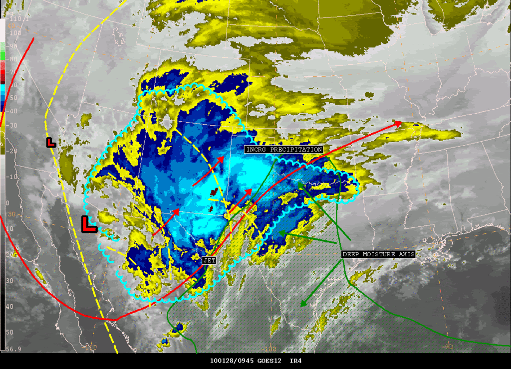
I'll repost this in the TX thread...
SATELLITE PRECIPITATION ESTIMATES..DATE/TIME 01/28/10 1010Z
SATELLITE ANALYSIS BRANCH/NESDIS---NPPU---TEL.301-763-8678
LATEST DATA USED: GOES-12/11 0945Z KUSSELSON
.
LOCATION...W TEXAS...OKLAHOMA...S COLORADO...NEW MEXICO...
LOCATION...ARIZONA...
.
ATTN WFOS...OUN...SJT...LUB...AMA...MAF...PUB...ABQ...EPZ...TWC...
ATTN RFCS...ABRFC...WGRFC...CBRFC...
.
EVENT...MOISTURE AND DYNAMICS ALL COMING TOGETHER...INCRG PRECIP NM TO
W TX TO OKLAHOMA...
.
SATELLITE ANALYSIS AND TRENDS...MAIN UPPER LOW BEGINNING TO SLOWLY OPEN
UP A BIT ACROSS NW OLD MEXICO AS SATELLITE WIND SPEED MAX OF NEAR 90KTS
COMES AROUND THE BOTTOM OF THE TROUGH (ACROSS W CENTRAL OLD MEXICO.)
THIS IN COMBO WITH VARIOUS SHORT WAVES COMING OUT AHEAD OF THE TROUGH
AND BLENDED TOTAL PRECIPITABLE WATER LOOP SHOWING AN EXPANSION OF DEEP
MOISTURE NORTH AND NW THRU TEXAS WILL HELP EXPLODE PRECIP TODAY ACROSS
W TEXAS INTO OKLAHOMA. IN THE IMMEDIATE FUTURE...COOLING CLOUD TOPS
SE NM INTO W CENTRAL TEXAS SETTING THE STAGE FOR INCRG PRECIP THERE THIS
MORNING AND A MAX PRECIP OF AN INCH OR MORE POSSIBLY CENTERED IN SW TO
W CENTRAL TEXAS FOR THE 12-18Z PERIOD AND THEN MIGRATING INTO OKLAHOMA
FOR THE 18-00Z ON THE WESTERN FRINGES OF THE ALREADY DEEPENING MOISTURE
AXIS THAT NOW WAS CENTERED FROM S CENTRAL TX TO S CENTRAL OK. AND IF
THAT WAS NOT ENOUGH...GPS SITES ACROSS THE AREA WERE ALREADY SHOWING
AN EXCELLENT PW MOISTURE GRADIENT FROM N CENTRAL TX (NEAR 1 INCH) TO
N CENTRAL OK WHERE PWATS WERE STEADY AT 0.4" WHICH SHOULD MAKE FOR AN
ADDITIONAL EXCELLENT OVERRUNNING AREA.
ON THE BACK SIDE OF LOW...WATER VAPOR LOOP SHOWING DARKENING ACROSS
S CA AND HANGBACK JET S CA INTO OLD MEXICO THAT COULD ALLOW FOR SOME
MOISTURE WRAP BACK IN AZ FOR MOST OF THE DAY...THERE MAY BE SOME TROWEL
CHARACTERISTICS DEVELOPING BACK THERE DURING THE DAY THAT WOULD FURTHER
CONFIRM THAT. UPPER SYSTEM NOW NEAR THE NW OLD MEXICO-S CENTRAL AZ
BORDER WILL BE SLOW MOVE EAST...SINCE NO REAL GOOD KICKER UPSTREAM IS
IDENTIFIED FOR THE NEXT 6HRS.
WILL CONTINUE TO MONITOR...SEE SATELLITE ANALYSIS GRAPHIC SHORTLY ON
HOME PAGE ADDRESS BELOW...
.
SEE NCEP HPC DISCUSSION AND QPF/S FOR FORECAST.
....NESDIS IS A MEMBER OF 12 PLANET....
.
SSD/SAB WEB ADDRESS FOR PRECIP ESTIMATES:
HTTP://WWW.SSD.NOAA.GOV/PS/PCPN/
...ALL LOWER CASE EXCEPT /PS/PCPN/
0 likes
Carla/Alicia/Jerry(In The Eye)/Michelle/Charley/Ivan/Dennis/Katrina/Rita/Wilma/Ike/Harvey
Member: National Weather Association
Wx Infinity Forums
http://wxinfinity.com/index.php
Facebook.com/WeatherInfinity
Twitter @WeatherInfinity
Member: National Weather Association
Wx Infinity Forums
http://wxinfinity.com/index.php
Facebook.com/WeatherInfinity
Twitter @WeatherInfinity
-
Weatherdude20
Re: Texas winter wx thread (2009-2010)
Thanks Weatherdude...that's what I thought, but I am still learning. So other than possibly more rain for DFW, does this really change anything as far as frozen precipitation goes? Thanks in advance.
Ill go into more detail later, but as far as a change for more precip, IF that map verifies, then yes it will be become more likely for additional winter precip opportunity, Especially in your neck of the woods...(Denton)
EDIT: Also, in the Denton area thursday night through noon friday, Freezing rain will be a possibility causing some light icing on elevated surfaces. Don't be suprised of there is a brief transition to light sleet tomorow, no signifigant accumulations expected.
The following post is NOT an official forecast and should not be used as such. It is just the opinion of the poster and may or may not be backed by sound meteorological data. It is NOT endorsed by any professional institution including storm2k.org. For official information, please refer to NWS products
0 likes
Who is online
Users browsing this forum: No registered users and 27 guests